

Vessel monitoring system
Encyclopedia
Commercial fishing
Commercial fishing is the activity of catching fish and other seafood for commercial profit, mostly from wild fisheries. It provides a large quantity of food to many countries around the world, but those who practice it as an industry must often pursue fish far into the ocean under adverse conditions...
to allow environmental and fisheries regulatory organizations to monitor, minimally, the position, time at a position, and course and speed of fishing vessels. They are a key part of monitoring control and surveillance
Monitoring control and surveillance
Monitoring, control and surveillance , in the context of fisheries, is defined by the Food and Agriculture Organization of the United Nations as a broadening of traditional enforcing national rules over fishing, to the support of the broader problem of fisheries management.Internationally, the...
(MCS) programs at the national and international levels. VMS may be used to monitor vessels in the territorial waters of a country or a subdivision of a country, or in the Exclusive Economic Zone
Exclusive Economic Zone
Under the law of the sea, an exclusive economic zone is a seazone over which a state has special rights over the exploration and use of marine resources, including production of energy from water and wind. It stretches from the seaward edge of the state's territorial sea out to 200 nautical...
s (EEZ) that extend 200 nautical mile
Nautical mile
The nautical mile is a unit of length that is about one minute of arc of latitude along any meridian, but is approximately one minute of arc of longitude only at the equator...
s (370.4 km) from the coasts of many countries.
Detail of VMS approved equipment and operational use will vary with the requirements of the nation of the vessel's registry, and the regional or national water in which the vessel is operating. Fisheries followed by VMS fall into two main categories:
- Local/regional fish such as scallops in the Northeast U.S., anchovies in Peruvian waters, or rock shrimp in the Gulf of Mexico
- Highly migratory species (HMS) such as tuna and billfish, or Patagonian toothfish (Dissostichus eleginoides) in the Antarctic. which can be caught in multiple regions
In this discussion, VMS relates specifically to fisheries management systems. VMS is sometimes used as an informal synonym for other such things as the Automatic Identification System
Automatic Identification System
The Automatic Identification System is an automatic tracking system used on ships and by Vessel traffic services for identifying and locating vessels by electronically exchanging data with other nearby ships and AIS Base stations...
(AIS) or Vessel Traffic Service
Vessel Traffic Service
A vessel traffic service is a marine traffic monitoring system established by harbour or port authorities, similar to air traffic control for aircraft...
(VTS). AIS and VTS are quite different from VMS, although they may be complementary may apply to marine oversight and sensing programs that deal with the safety of navigation, hazardous material spills, and environmental threats such as algal blooms. VMS uses different radio technologies, is long-range, and handles commercially sensitive information.
Since VMS components are expensive, most countries subsidize the purchase of equipment, although the vessel owner may have to pay for installation, maintenance, and continuing communications costs. The communications service used can optionally support other functions such as voice, electronic mail, and other applications over which the communications cost can be amortized. VMS cost is a significant obstacle to its use in developing countries, but there are a number of subsidy programs to encourage VMS use.
VMS from marine electronics
Marine electronics
Marine electronics refers to electronics devices designed and classed for use in the marine environment where even small drops of salt water will destroy electronics devices...
suppliers may also offer a variety of other optional functions that can help in navigation, economic analysis, safety, and finding fish to harvest.
Applications
VMS is intended principally for fisheries management, but the country using it may use the data for other purposes. See the broad framework of Monitoring control and surveillanceMonitoring control and surveillance
Monitoring, control and surveillance , in the context of fisheries, is defined by the Food and Agriculture Organization of the United Nations as a broadening of traditional enforcing national rules over fishing, to the support of the broader problem of fisheries management.Internationally, the...
Fisheries management
Among the most basic purposes is to monitor the movement of VMS-equipped vessels with respect to restricted fishing areas. A given vessel may have approval to fish in a restricted area, to transit through it without fishing, or it may not be allowed in the area.Catch reporting
Not all VMS systems have the software to record and transmit catch reports. On the systems with separate PCs, it is reasonably easy to distribute separate software, although the fishermen may or may not be able to install it without assistance. For VMS with dedicated PCs, additional software can be made part of software support with established channels.There is a distinct trend to making catch reporting part of an overall MCS program, although current VMS systems rarely integrate this capability with position reporting.
Under the European Union scheme, vessels are generally required to report
- Catch on entry
- Weekly catch
- Transshipment
- Port of landing
- Catch on exit
Within the EU an Electronic Reporting System
Electronic Reporting System
The Electronic recording and reporting system is used by EU countries to record, report, process, store and send fisheries data including catch, landing, sales and transhipment....
is being implemented to automate collection of catch data, and exchange of data between EU states. A number of programs require tracking of days at sea (DAS) for a given vessel. They may require tracking the total cumulative catch of a given fishery.
Fisheries research & analysis
VMS is a planning and analysis tool as well as an aid to operations. Treated as a research database, the cumulative position reports gives an analysis of fishing vessel tracks in search of fish. Coupled with species-specific fishing licenses and catch reports, fisheries managers can estimate the amount of a given fish in an area, the amount taken by fishing vessels, and project overfishing before it happens.Safety
VMS itself can help in search and rescueSearch and rescue
Search and rescue is the search for and provision of aid to people who are in distress or imminent danger.The general field of search and rescue includes many specialty sub-fields, mostly based upon terrain considerations...
(SAR), especially when the SAR organization participates in the Global Maritime Distress Safety System
Global Maritime Distress Safety System
The Global Maritime Distress and Safety System is an internationally agreed-upon set of safety procedures, types of equipment, and communication protocols used to increase safety and make it easier to rescue distressed ships, boats and aircraft....
(GMDSS). Some VMS have built-in Emergency Position-Indicating Radio Beacon
Emergency Position-Indicating Radio Beacon
Distress radio beacons, also known as emergency beacons, ELT or EPIRB, are tracking transmitters which aid in the detection and location of boats, aircraft, and people in distress. Strictly, they are radiobeacons that interface with worldwide offered service of Cospas-Sarsat, the international...
s (EPIRB), although a dedicated VMS unit may not be able to have an emergency beacon that automatically floats to the surface and starts transmitting when it detects it is in salt water. At the very least, the SAR agency can get a last reported location of the vessel, and perhaps its course, from the FMC.
Enforcement
VMS obviously is part of fisheries enforcement, but, along with other systems, it can be part of overall sea surveillance. When a radar or other sensor detects a given vessel, VMS can tell the center that monitors the radar whether the radar target is a known fishing vessel.There may be correlation between AIS/VTS and VMS.
Technologies and components
VMS involves technology on the vessel, ashore, and communications between them. In addition, there may be additional communications from the Fisheries Management Center (FMC) of the vessel's country of registry, and regional or national FMCs of the waters in which the vessel is fishing.Functions aboard the vessel
The most basic function of a VMS is to determine the vessel's location at a given time, and periodically send this information, usually by satellite, to a monitoring station ashore.VMS components on the vessel sometimes are called VMS, or sometimes Automatic Location Communicators (ALC). These minimally include a GPS antenna and receiver, a computer (which may be embedded or user-supplied), and a transmitter and antenna appropriate for the communications that links the vessel to the flag center.
In practice, many of the VMS components also have applicability, along with non-VMS marine electronics, to a wide range of functions aboard a fishing vessel. These include navigation, finding fish, collision avoidance, routine voice and email communications, etc.
Selecting a VMS system is most dependent on what vendors and models have been approved by the fishing vessel's state of registry. If there is a choice, then consider that the greatest flexibility to add components is with a system that does not have an embedded computer. If there is not an embedded computer, however, the vessel's owners will have to take more responsibility, perhaps through a contractor or installer, for keeping the software updated and integrating new software components without interfering with VMS functionality.
Especially when the user supplies the computer (i.e., the VMS consists of the radio gear and software only), VMS often have, in addition to the pure location transmission function, some level of fusing the various data sources with electronic charts.
VMS software and devices for the fishing vessel include:
- Absolute Software
- AMS
- Argos CLS
- AST Ltd
- Bluefinger/Thales
- Boatracs
- Faria
- Skymate
- Thrane & Thrane
- vTrack VMS
- Satamatics
- BlueTraker
- Free Port - Eye from a sky
Communications
VMS units principally rely on GPS for position and time information. LORAN may be a backup or complementary technology. They report data to monitoring systems generally using satellite systems from InmarsatInmarsat
Inmarsat plc is a British satellite telecommunications company, offering global, mobile services. It provides telephony and data services to users worldwide, via portable or mobile terminals which communicate to ground stations through eleven geostationary telecommunications satellites...
, Iridium
Iridium
Iridium is the chemical element with atomic number 77, and is represented by the symbol Ir. A very hard, brittle, silvery-white transition metal of the platinum family, iridium is the second-densest element and is the most corrosion-resistant metal, even at temperatures as high as 2000 °C...
, Argos
Argos System
Argos is a satellite-based system which collects, processes and disseminates environmental data from fixed and mobile platforms worldwide. What makes Argos unique is the ability to geographically locate the source of the data anywhere on the Earth utilizing the Doppler effect...
, ORBCOMM
Orbcomm
ORBCOMM is a company that offers M2M global asset monitoring and messaging services from its constellation of 29 LEO communications satellites orbiting at 775 km. Like its voice-centric competitors Iridium and Globalstar, it filed for Chapter 11 protection, in September, 2000. ORBCOMM issued...
or Qualcomm
Qualcomm
Qualcomm is an American global telecommunication corporation that designs, manufactures and markets digital wireless telecommunications products and services based on its code division multiple access technology and other technologies. Headquartered in San Diego, CA, USA...
. Some nations, such as Iceland, are experimenting with coastal VHF repeaters for VMS communications.
- Operated by Inmarsat plc, originally founded by governments but now commercial, Inmarsat has a constellation of geosynchronous communications satellites.
- Iridium uses a constellation of 66 Low Earth OrbitLow Earth orbitA low Earth orbit is generally defined as an orbit within the locus extending from the Earth’s surface up to an altitude of 2,000 km...
satellites to provide complete global coverage (including all ocean regions and both poles) with real time coverage. - Argos uses Low Earth OrbitLow Earth orbitA low Earth orbit is generally defined as an orbit within the locus extending from the Earth’s surface up to an altitude of 2,000 km...
European and US satellites in polar orbit, which is an especially appropriate orbit for vessels operating in high latitudes. - Skymate uses OrbcommOrbcommORBCOMM is a company that offers M2M global asset monitoring and messaging services from its constellation of 29 LEO communications satellites orbiting at 775 km. Like its voice-centric competitors Iridium and Globalstar, it filed for Chapter 11 protection, in September, 2000. ORBCOMM issued...
LEO satellites, which is optimized for machine-to-machine communications, potentially at lower cost than voice-capable satellite systems. They operate in the VHF and UHF bands, and have demonstrated an AISAutomatic Identification SystemThe Automatic Identification System is an automatic tracking system used on ships and by Vessel traffic services for identifying and locating vessels by electronically exchanging data with other nearby ships and AIS Base stations...
capability. - QualcommQualcommQualcomm is an American global telecommunication corporation that designs, manufactures and markets digital wireless telecommunications products and services based on its code division multiple access technology and other technologies. Headquartered in San Diego, CA, USA...
provides access to the IridiumIridiumIridium is the chemical element with atomic number 77, and is represented by the symbol Ir. A very hard, brittle, silvery-white transition metal of the platinum family, iridium is the second-densest element and is the most corrosion-resistant metal, even at temperatures as high as 2000 °C...
satellite systems. - BlueTraker uses both GPRS and Iridium constellation to provide the biggest flexibility and the lowest communication costs. The BlueTraker is a stand alone device fully integrated including the antennas, the communication modules and a back-up battery. It is also e-logbook ready.
VMS/ALC Vendor Product type Communications Communications type Applied Satellite Technology Dedicated computer with voice and email Inmarsat-C Geosynchronous satellite Bluefinger/Thales GPS & uplink antenna; PC software for VMS, log Inmarsat Geosynchronous satellite Blue Oceans Satellite Systems GPS; duplex communication; Web-based monitoring interface Iridium and Globalstar Low-earth orbiting (LEO), cross-linked satellites operating as a fully meshed network and supported by multiple in-orbit spares. Boatracs Dedicated with phone, fax, email Qualcomm LEO L-band uplink CLS America GPS with uplink Argos Polar LEO Satrax ETS-1000 Dedicated computer with telephone Iridium Polar LEO with satellite-to-satellite Satrax ETS-250 Dedicated computer Orbcomm Polar LEO with satellite-to-satellite Skymate GPS & uplink antenna; PC software for VMS, weather, fish prices, surface temperature, log Orbcomm LEO VHF Uplink Thrane & Thrane Dedicated computer with voice and email Inmarsat-C Geosynchronous satellite Satamatics or Skywave SkyWave Mobile CommunicationsSkyWave Mobile Communications is a satellite telematics company that provides satellite transceivers, dual-mode satellite/GPRS terminals and satellite network services for global tracking, monitoring, and control of mobile and stationary assets...Low-cost, small transceivers with integrated GPS Inmarsat-D+ Geosynchronous satellite EMA - BlueTraker all-integrated Hybrid device (GPRS and satellite communications)with internal back-up battery, antennas and e-logbook capabilities GPRS & Iridium Polar LEO with satellite-to-satellite Free Port - Eye from a sky (Maestral 2009) integrated black-box device (GPS positioning, GPRS/EDGE and satellite communications) with internal back-up battery, external antenna and PC software for monitoring, surveillance, communication and data gathering GPRS/EDGE & Iridium Polar LEO with satellite-to-satellite
Fisheries management center of the vessel's nation
Software at the fisheries management organization looks for several pieces of information:- location vis-a-vis restricted area
- time at sea
- time in restricted area, possibly separating fishing and transit time by speed
A restricted area may be closed for all purposes, open to transit, open to fishing for a specific period, or open to designated vessels only. Vessel speed is often the way its status is determined in lieu of direct observation. Some VMS directly report speed, or speed can be calculated by FMS software based on the time stamps of different position reports. A rule of thumb in scallop fisheries, for example, is that the vessel cannot be dredging for scallops if its speed is greater than 5 knots (10 km/h).
FMC software can note the time a vessel leaves and returns to port, and the time it is inside or outside designated areas. There may be restrictions on trip length, time in an area, etc., which can be calculated directly from VMS data. Other observations may require correlation of catch reports with the vessel's presence in given areas. Presence in other areas may require an onboard observer.
Individual regional, national, and international FMCs have different levels of software intelligence, which can detect patterns of interest to SAR, fisheries management, or law enforcement.
Fisheries monitoring center of the waters being fished
Countries with registered fishing vessels that employ VMS generally agree to set up a Fisheries Monitoring Center (FMC), which has a data network connection to the FMCs of other states. This flag state principle requires all vessels, registered in a given state to transmit their positions automatically to that state's FMC. When the vessel enters the waters of a different state, the home FMC must forward the report of the vessel's entry into those waters to the foreign state FMC. Until the vessel leaves the foreign state's coastal area, the home FMC must forward to the foreign state FMC the position, speed, and course reports at least every two hours. Exchange of data between VMS servers within the EUEuropean Union
The European Union is an economic and political union of 27 independent member states which are located primarily in Europe. The EU traces its origins from the European Coal and Steel Community and the European Economic Community , formed by six countries in 1958...
is regulated by the European Commission
European Commission
The European Commission is the executive body of the European Union. The body is responsible for proposing legislation, implementing decisions, upholding the Union's treaties and the general day-to-day running of the Union....
to be formatted according to the NAF FORMAT,
originally devised by NAFO and subsequently adopted in a slightly different format by NEAFC. VMS servers outside of the EU
European Union
The European Union is an economic and political union of 27 independent member states which are located primarily in Europe. The EU traces its origins from the European Coal and Steel Community and the European Economic Community , formed by six countries in 1958...
may optionally also use the NAF format due to its widespread use within the EU. Data is usually transmitted using HTTPS
Https
Hypertext Transfer Protocol Secure is a combination of the Hypertext Transfer Protocol with SSL/TLS protocol to provide encrypted communication and secure identification of a network web server...
protocol either by an HTTP Post
POST (HTTP)
In computing, POST is one of many request methods supported by the HTTP protocol used by the World Wide Web. The POST request method is used when the client needs to send data to the server as part of the request, such as when uploading a file or submitting a completed form.In contrast to the GET...
or an HTTP Get request. Other protocols such as X.25
X.25
X.25 is an ITU-T standard protocol suite for packet switched wide area network communication. An X.25 WAN consists of packet-switching exchange nodes as the networking hardware, and leased lines, Plain old telephone service connections or ISDN connections as physical links...
have historically been used but are in decline.
If position reports unexpectedly cease from a vessel, the FMC for the ocean area from which the last signal was received must attempt to contact the vessel or the flag state FMC without delay. Since VMS reports are sent automatically, it is possible that there is nothing wrong with the vessel itself, only the VMS. A full search and rescue (SAR) operation should not be launched simply because a VMS report does not arrive, although it is reasonable to alert sea surveillance assets, such as radars, that might be able to find the vessel. Fishing vessel crews should check the VMS at reasonable intervals, and confirm it is working.
While the procedure will vary with the jurisdiction, if an at-sea vessel finds their VMS is not working and they cannot fix it, they may be able to contact the FMC and get permission to continue the voyage. If they do get such authorization, they may get an inspection when they return to port. The FMC may also order them back to port. It is unlikely they will be allowed to leave port again without the VMS being repaired, so that they may need 24/7
24/7
24/7 is an abbreviation which stands for "24 hours a day, 7 days a week", usually referring to a business or service available at all times without interruption...
VMS technical services at their home port.
Position reports received by the FMC should be forwarded automatically to the FMC of the vessel's registry. FMCs and other organizations, such as SAR and research, which receive VMS data must comply with confidentiality agreements. All recipients of data are also in accordance with agreements obliged to handle the data they receive in a responsible manner.
Catch documentation scheme
Catch reports are not themselves part of VMS, but often will be correlated with VMS data as part of an overall fisheries MCSMonitoring control and surveillance
Monitoring, control and surveillance , in the context of fisheries, is defined by the Food and Agriculture Organization of the United Nations as a broadening of traditional enforcing national rules over fishing, to the support of the broader problem of fisheries management.Internationally, the...
program.
AIS, VTS and GMDSS
These safety and traffic management systems are not interoperable with VMS. VMS has privacy requirements they do not, and uses different technical standards.Nevertheless, a vessel required to have some or all of these capabilities may share some onboard equipment, such as computers, displays, or antennas. SAR and other safety agencies that can protect VMS data may combine data received by an FMC with their own information systems. Law enforcement organizations can combine VMS data with their own sensors and intelligence when a fishing violation is within their authority.
International programs
Given that fish exist in food chainFood chain
A food web depicts feeding connections in an ecological community. Ecologists can broadly lump all life forms into one of two categories called trophic levels: 1) the autotrophs, and 2) the heterotrophs...
s, it is worth nothing that the United Nations
United Nations
The United Nations is an international organization whose stated aims are facilitating cooperation in international law, international security, economic development, social progress, human rights, and achievement of world peace...
is at the logical top of the VMS chain, under the authority of the United Nations Convention on Law of the Sea (UNCLOS). While it does not contain any provisions that are directly related to the use of VMS, it establishes a number of important principles of relevance for this study, relating to the conservation and management of living resources, both within national jurisdictions and on the high seas.
UN fisheries operations are under the Food and Agricultural Organization.
Antarctic
Under the Commission for the Conservation of Antarctic Marine Living ResourcesConvention for the Conservation of Antarctic Marine Living Resources
The Convention on the Conservation of Antarctic Marine Living Resources, also Commission on the Conservation of Antarctic Marine Living Resources, and CCAMLR, is part of the Antarctic Treaty System...
(CCAMLR),
a number of member states monitor agreed-to conservation measures and research information. The major emphasis is on the Dissostichus sp. catch (i.e., Patagonian toothfish
Patagonian toothfish
The Patagonian toothfish, Dissostichus eleginoides , is a fish found in the cold, temperate waters of the southern Atlantic, southern Pacific, Indian, and Southern Oceans on seamounts and continental shelves around most sub-Antarctic islands.A close relative, the Antarctic toothfish , is found...
and Antarctic cod
Antarctic cod
The Antarctic cod, or Antarctic toothfish, of the fish family Nototheniidae, is famous for producing antifreeze glycoprotein that allows it to survive in the ice-laden waters of the Southern Ocean surrounding Antarctica...
) also known as Chilean sea bass.
Realtime VMS is required for most exploratory VMS, with delayed reporting for other longline fisheries and for finfish trawling. The flag state VMS architecture is used, where the national FMCs of vessel registry, starting in 2005, transmit to the CCAMLR regional FMC.
Member states under the agreement are Argentina, Australia, Belgium, Brazil, Chile, European Community, France, Germany, India, Italy, Japan, Republic of Korea, Namibia, New Zealand, Norway, Poland, Russian Federation, South Africa, Spain, Sweden, Ukraine, United Kingdom of Great Britain and Northern Ireland, United States of America, and Uruguay. In addition, Bulgaria, Canada, Finland, Greece, Netherlands, Peru,and Vanuatu accede to the convention. In practice, up to 50 vessels are expected to be monitored, and about 15 of the convention states actually fish in the area. The longline vessels range from 349 to 2,203 long ton
Long ton
Long ton is the name for the unit called the "ton" in the avoirdupois or Imperial system of measurements, as used in the United Kingdom and several other Commonwealth countries. It has been mostly replaced by the tonne, and in the United States by the short ton...
s (355 to 2,238 t).
Depending on the latitude, satellite communications may require polar-orbiting satellites, or the vessel may be in line of sight of a geosynchronous satellite.
Europe
Under the European Union legislation, VMS is a legal requirement for vessels in excess of 15 metres.By 1999, Europe had 7000 vessels, in excess of 15 meters, under VMS. Since 2005, all Community vessels automatically transmit vessel identification, date, time, position, course and speed either hourly or every 2 hours (if the responsible Fisheries Monitoring Centre can request positions). The only exception is for vessels that operate only inside home waters, and are used exclusively for aquaculture.
One of the challenges for European MCS is that the idea of a 200 nautical miles (370.4 km) EEZ is meaningless for nations with coasts in small seas such as the Mediterranean or Baltic. In such circumstances, appropriate international agreements need to be developed to govern fishing beyond the territorial limit and thus on the high seas, but high seas that would have overlapping jurisdiction in an EEZ-based model.
There are precedents where maritime pollution already is handled on a basin basis, which might provide a framework for fisheries enforcement in international waters of a small sea:
- Mediterranean (Barcelona Convention)
- Baltic (Helsinki Convention)
- North Sea (Bonn Agreement)
A recent IMO regulation requires AIS transponders aboard vessels, which transmit identifier, name and position of vessels not limited to fishing.
Another approach might involve either AIS, or the more finely grained VTS, agreements that use coastal radar to monitor ships in and beyond coastal waters. This allows a transport vessel, for example, to be tracked in the small sea.
Another cross-check could involve current EU RADARSAT ScanSAR imagery, correlated with transponder information, such that only radar images of ships without active transponders display to enforcement personnel. At present, however, inspectors on aircraft or surface patrol vessels may not have real-time access to satellite imagery. Currently, the fusion of VMS, radar (satellite, aircraft, or coastal) has to be done at an operations center ashore. Another complication is that enforcement organizations for such things as spill monitoring are not concerned with issues such as illegal fishing.
Northwest Atlantic
The Northwest Atlantic Fisheries Organization is composed of Canada, Cuba, Denmark (in respect of the Faroe Islands and Greenland), European Union, France (in respect of St Pierre et Miquelon), Iceland, Japan, Republic of Korea, Norway, Russian Federation, Ukraine, United States of America.Under this agreement are all fisheries, principally trawl and longline, except crab, lobster, salmon, sedentary species, whale and tuna. Approximately 135 vessels are monitored, the majority of which are trawlers with a few longline, ranging from 500 to over 2000 gross weight tons (GWT).
The VMS software used is vTrack.
Northeast Atlantic
Under the Northeast Atlantic Fisheries Commission (NEAFC), Denmark (in respect of the Faroe Islands and Greenland), European Union, Iceland, Norway, Poland, Russian Federation.This agreement covers all fisheries in the high seas of the regulated area, including trawlers, purse seiners, longliners, and gill netters. In 2004, 1473 vessels were monitored, with 800 authorized to fish for regulated species.
VMS is required for any vessel of 24 meters or longer overall length. NEAFC is a secondary user of data from flag state FMCs; the regional FMC connects to national Germany, Denmark, Spain, Estonia, France, Faroe Islands, United Kingdom, Greenland, Ireland, Iceland, Latvia, Lithuania, Netherlands, Norway, Poland, Portugal, Russian Federation, Sweden, and, occasionally in the past, Japan and New Zealand. It also connects to the European Commission FMC.
Fisheries surveillance vessels will transmit, to the FMC, information on their operations with respect to VMS-equipped vessels, including:
- surveillance entry
- observations
- prepare for inspection
- surveillance exit
NEAFC participated as an observer in, a project funded by the EU to use satellite radar images to validate VMS information and to complement and optimise surveillance tasks. NEAFC decided, based on the results of the EU-funded IMPAST (Improving Fisheries Monitoring By Integrating Passive and Active Satellite Technologies), to deploy a Vessel Detection System (VDS) in several coastal states.
NEAFC is also participating in the EU-funded SHEEL (Secure and Harmonized European Electronic Logbook) and CEDER (Catch, Effort and Discard Estimate in Real-time) projects, which may lead to direct electronic reporting of real-time catch data.
Pacific Islands
The FFA has 16 country members and one territory member from the western and central Pacific region. It is based in Honiara, Solomon Islands. While the FFA proper was formed over 20 years ago, VMS operation began in late 1997, covering the EEZs of 16 South Pacific countries.FFA VMS is expected to cover 2000+ vessels, transmitting via Inmarsat-C and reporting every 4 hours.
Southern Africa
Fisheries are a major component of the economies of the coastal member states of the SADC (Angola, Namibia, South Africa, Mozambique, Tanzania, Mauritius and Seychelles).Due to limited resources, there is little VMS beyond experiments in Namibia and South Africa. There is a European Union funded project to improve monitoring.
West Africa
The Sub-Regional Fisheries Commission (SRFC) based at Dakar, Senegal is made up of west African States, namely Cape Verde, The Gambia, Guinea, Guinea-Bissau, Mauritania, Sierra Leone and Senegal. Its role is to promote fisheries cooperation between its member States.The donor is the Grand Duchy of Luxembourg and the executing agency is the FAO and Lux-Development. Participating countries are These countries are members of the Sub-Regional Fisheries Commission (CRSP) with the addition of Sierra Leone. The project proposed is a continuation and extension of the AFR/101 Project (FAO), which may add VMS to supplement the present air surveillance.
National
This section deals with the specifics of national use of VMS, rather than their overall approach to fisheries management.Albania
Albania is currently implementing a VMS for its 220 vessels fishing fleet, combining satellite and GPRS communications channels. The BlueTraker VMS solution, which is E-Logbook ready, is supplied by company EMA.Argentina
The Commission for the Conservation of Antarctic Marine Living Resources demands the consensus of its 24 member countries for any proposals to be implemented. At its annual meeting in Hobart over the past two weeks, Argentina could not be persuaded to approve the adoption of a centralised system to monitor pirate ships.The Parliamentary Secretary to the Minister for Environment, Sharman Stone, says Argentina was suspicious of the technology. "Argentina was concerned that we couldn't guarantee the confidentiality of any system, now the technical requirements of such a system were agreed that this wasn't beyond anyone's technical ability and capacity, but unfortunately Argentina remained concerned about the confidentiality of the data," she said.
However, the commission has agreed that Australia and the United States will head up a trial of the centralised vessel monitoring system over the coming season.
Australia
Australia has both national and state programs. The national-level program is run by the Australian Government agency, the Australian Fisheries Management AuthorityAustralian Fisheries Management Authority
The Australian Fisheries Management Authority is the Australian Government statutory agency responsible for the management and sustainable use of fisheries resources and for combating illegal fishing activities in Australian waters .-History:The Australian Fisheries Management Authority was...
(AFMA). VMS runs on about 500 (growth expected to 800) vessels from small 10-meter scallop boats to 850-meter deep sea trawlers.
Fisheries of interest include orange roughy, scallops, prawns, tuna and billfish. Fishers must use AFMA-approved VMS devices.
Southern Australia
There is a regional organization of Southern Australian states which monitors rock lobster, giant crab, and, on a sampling basis, aquaculture.Canada
Since 2001, Canada has mandated VMS, for vessels of certain sizes, to fish for specific species in designated areas. The underlying MCS strategies, while differing in specific fisheries, are based on limited entry licensing, with restrictions on vessel and gear types. Canada expects VMS reports every two hours.Canadian activities involving VMS are joint between the Department of Fisheries & Oceans (DFO) and the Department of National Defense (DND).
DND is the lead department for an inter-Departmental web-based mapping application, supported by positional information from DFO.
DND provides non-VMS surveillance data to a DND-operated data base available to DFO for fisheries management. Aerial surveillance, using a variety of sensors, monitors freighters, tankers, bulk carriers and container ships as well as fishing vessels.
Canada intends to provide, in real time, VMS data, correlated with other sensors and database information, to patrol vessels and aircraft. Electronic logs, two-way communication with fishing vessels, issuing orders, and possibly placing video and other sensors on fishing.
Chile
Chile has VMS aboard approximately 500 vessels, each vessel being associated with one fishery.Marimsys built the Chilean VMS, but that system was be replaced in 2007 with a new one provided by CLS.
Chile went from a government-specified VMS to a type-approval system for VMS units in an open market, which drove down costs.
Monitored industrial fishing boats limit fishing activities to—generally—5 nautical miles (9 km) from the coast of Chile. This leaves the 5 nm zone for “artisanal” or smaller fishing boats and limits excessive fishing effort being applied to inshore waters.
Chile also pioneered in the emission of reports at short intervals. Prior systems had focussed on “where is the vessel” with the provision of hourly reporting. The Chilean system, by dropping the minimum report interval to 8 minutes is capable of determining “what” the vessel is doing. When you see a series of circular positions, they are all at speeds of below 2 knots (4 km/h) and reflect the drift of the current—there is no question, that vessel was purse seining, and the printout of the chart can be shown to the court to demonstrate the fact.
Chile is currently the world’s largest producer of farmed salmon and has a burgeoning mussel culture industry that is supplying a growing world market. Other fisheries of interest include alfonsino, anchovies, cod, cuttlefish, hake, mackerel, ray, sardines, sea bream, squid, and swordfish.
The system is also used to monitor foreign vessels entering and leaving both the EEZ and Chilean ports.
China
China has national and provincial VMS programs, the most active being for Taiwan.It uses both Inmarsat-C and Argos to monitor up to 1200 vessels.
Croatia
Croatia has implemented its VMS on 256 vessels in 2007. The BlueTraker VMS solution, supplied by EMA, enables utilization of both satellite and GPRS communication channels.Denmark
Denmark has a nation-wide VMS based on Inmarsat-C transceivers owned and maintained by the authorities. The VMS software is vTrack.The system monitors 600 vessels.
Ecuador
Ecuador uses VMS for tuna, under the Association of Tuna Fishing Companies of Ecuador (ATUNEC).Estonia
Estonia has a nation-wide VMS based on Inmarsat-C hardware and vTrack software. The system monitors 50 vessels. The Estonian VMS system is operated by the Estonian Environmental Inspectorate.Falklands Islands
The Falklands have a VMS program for approximately 30 vessels worldwide. There is a monitoring requirement for all vessels in the squid fishery.Faeroe Islands
Faeroe Islands has a nation-wide VMS based on Inmarsat-C hardware and vTrack software. The system monitors 150 vessels.France
Implementing its FMC at the CROSS sea rescue center at Etel, France uses the flag state principle described under Norway. The MAR-GE unit is a self-contained GPS and Argos device. France expects 2-hour reporting.Germany
The German VMS is based on Inmarsat-C transceivers. The VMS software is vTrack.The system monitors 300 vessels.
Greenland
Greenland VMS is based on Argos/CLS and Inmarsat-C transceivers. The VMS software is vTrack.The system monitors 100 vessels.
Iceland
Iceland uses VMS for both safety and fisheries compliance, monitoring with Inmarsat-C or a coastal VHF repeater system. Approximately 1600 vessels of all sizes are monitored. Thales VMS has been approved.India
India is introducing VMS for its EEZ, along with a system of permits to control capacity.Indonesia
The Indonesian Ministry of Maritime Affairs and Fisheries selected Argos for their VMS. Indonesia's VMS system is the largest, or among the largest, in the world. 1500 fishing vessels initially with VMS, with three ashore FMCs. A distinctive feature of the Indonesian system is that an initial 15 patrol boats can directly receive VMS information.Ireland
The Irish VMS system is operated by the Irish Naval ServiceIrish Naval Service
The Naval Service is the navy of Ireland and is one of the three standing branches of the Irish Defence Forces. Its main base is in Haulbowline, County Cork....
, based in County Cork. As well as monitoring Irish vessels, the VMS exchanges data with VMS systems operated by other EU states.
Japan
A framework for groundfish fisheries in the Northwest Pacific's high seas was established in January 2007 in a consultation involving Japan, Russia, South Korea and the United States.VMS will be used to collect data.
Lithuania
Lithuania has a nation-wide VMS based on Inmarsat-C hardware and vTrack software. The system monitors 50 vessels.Malaysia
Malaysia uses VMS on its Malaysian Maritime Enforcement Agency patrol boats and also on larger fishing vessels, through the Fisheries Department.Mexico
Under current Mexican law, it is illegal for commercial boats like longliners and drift gillnetters,to take fish reserved for sports fishing within fifty miles (93 km) of the coast in the Sea of Cortez, and any fish within 12 nautical miles (22 km) of the Revillagigedo Islands. VMS is seen as the only way Mexico will to enforce controls on areas in its EEZ.Morocco
Morocco are currently implementing a VMS system combining satellite tracking and radar correlation, supplied primarily by BlueFinger Ltd.Namibia
The fisheries in Namibia are among the largest in Africa, with some of the most sophisticated MCSMonitoring control and surveillance
Monitoring, control and surveillance , in the context of fisheries, is defined by the Food and Agriculture Organization of the United Nations as a broadening of traditional enforcing national rules over fishing, to the support of the broader problem of fisheries management.Internationally, the...
systems.
VMS is fully operational and has been implemented across many fishing fleets. Following an EU funded MCS program for the SADC region, Namibia has facilities to integrate its VMS data with that of other SADC partners so that information can be shared regarding vessels that operate across the border in another SADC states waters. Similarly, Namibia can receive VMS information from its SADC partners when a vessel from another SADC state enters its waters.
The observer program has been effective. Nevertheless, it may be appropriate, initially for the orange roughy
Orange roughy
The orange roughy, red roughy, or deep sea perch, Hoplostethus atlanticus, is a relatively large deep-sea fish belonging to the slimehead family . The Marine Conservation Society has categorized orange roughy as vulnerable to exploitation...
fishery.
Nauru
All foreign vessels licenced to fish or support fishing operations in Nauru waters are required to use an Automatic Location Communicator compatible and registered with the Regional Vessel Monitoring System serving the Forum Fisheries AgencyFFA
FFA is a three-letter acronym that may stand for:-Aviation and the military:* First Flight Airport, IATA code for the tiny airstrip in Kitty Hawk where the first flight occurred in 1903.* Free-fire area, in U.S...
and the Western and Central Pacific Fisheries Commission
Western and Central Pacific Fisheries Commission
The Western and Central Pacific Fisheries Commission is a treaty-based organisation. It was established to conserve and manage tuna and other highly migratory fish stocks across the western and central areas of the Pacific Ocean and commenced operations in late 2005...
. Nauru has VMS data-sharing agreements with several other FFA member countries. A list of vessels licenced to fish in Nauru fisheries waters is uploaded daily to the FFA website
Netherlands
The Netherlands has a nation-wide VMS based on Inmarsat-C hardware and vTrack software. The system monitors 500 vessels.New Zealand
New Zealand has been running VMS since April 1994, with coverage out to the EEZ border under national and state agencies, with a target of 1000 vessels reporting every 2 hours. National & State Fisheries Agencies are responsible for the management of Fisheries located within its EEZ.Vessels use either Argos or Inmarsat-C to report position every 2 hours
Norway
Norway requires VMS aboard all of its fishing vessels longer than 15 meters. Norway has established such a centre at the Directorate of Fisheries in Bergen. Norway currently has mutual tracking agreements with the EU, Russia, Iceland, the Faeroe Islands and Greenland.Panama
When Panama joined the International Commission for the Conservation of Atlantic Tunas (ICCAT) in 1998, in response to an ICCAT embargo on bluefin tuna, it committed to require licensing and equipping deep sea fishing vessels aith the Argo ELSA VMS.Peru
Peru uses VMS to manage its anchovy fishery. For Peru fishing is a prime source of foreign exchange, second only to mining. Over 1000 fishing vessels are tracked in Peruvian waters by Argos. The Peruvian government implemented a national fishing Vessel Monitoring System (VMS) in 1998 to monitor and track all fishing vessels in its Exclusive Economic Zone. One of the first major VMS system's in the world, the system continues to operate today and is a reference for other countries wishing to implement similar fisheries management capabilities.The country’s anchovy fishing fleet, which seeks the Peruvian anchovy Engraulis ringens, is the world’s largest single-species fishery, with an average of 8% of global landings.
For research, safety and monitoring purposes, vessels have the statutory obligation to use VMS, with industrial-scale fishing prohibited within 5 nautical miles (9 km) from the coast.
Russia
The Russian Federationhas an integrated system called SSM, for fisheries resource monitoring and has implemented a sectoral system for monitoring of the aquatic living resources, and for surveillance and control over the activities of the fishing vessels (SSM). SSM includes VMS monitoring of vessel positions.
SSM headquarters is in Moscow, with regional monitoring centers in Murmansk and Petropavlovsk-Kamchatskiy. The national system covers approximately 3800 vessels. Bilateral agreements exist with Faroes, Greenland Iceland, Japan, and Norway. Russia participates in the NAFO, NEAFC, and CCALMR multinational agreements. It regards SSM as integral to safety of navigation and SOLAS.
Russia has bilateral agreements with Japan. AMS builds a Russian VMS.
Murmansk Region
The Murmansk region covers Russian vessels in the Atlantic Ocean, the Azov, Black and Caspian Sea regions, and the western Arctic Sector/Slovenia
Slovenia has a nation-wide VMS based on Inmarsat-C hardware and vTrack software. The system monitors 7 vessels.South Africa
Fisheries management, including limited VMS, is under the Marine and Coastal Management (MCM) organization in the Department of Environmental Affairs and Tourism.Hake Merluccius spp.) trawl fishery is the mainstay of South Africa's fishing industry, and the center of regulatory efforts.
On-board observers had been the mainstay of monitoring, rather than VMS.
VMS is aboard many vessels with reporting to an FMC in Cape Town that is equipped with BlueFinger's VMS software. Additional VMS will go onto vessels into more distant waters, such as hake longliners. VMS is seen as a management, a research, and a safety tool.
South Africa is exploring correlating its VMS with:
- RadarSat off Prince Edward Island, possibly in lieu of patrol vessels there,
- Airborne Synthetic Aperture RadarSynthetic aperture radarSynthetic-aperture radar is a form of radar whose defining characteristic is its use of relative motion between an antenna and its target region to provide distinctive long-term coherent-signal variations that are exploited to obtain finer spatial resolution than is possible with conventional...
for quick-look surveillance and coverage out to the edge of the EEZ. - Coastrad, a system of linked coastal radars for monitoring specific vessels, as verifying that foreign fishing vessels conducting innocent passage do that, rather than fish
- Patrol vessels to back up all other sensors.
South Korea
The Korean Squid Fishing Association has 102 fishing veesels which are to be equipped with an Argos satellite transmitter for their fishing campaigns in Russia.Suriname
CLS/Argos is under the Ministry of Agriculture, Farming and Fisheries, and was initially deployed on over 80 vessels.United Kingdom
The Marine Management Organisation (England & Wales), Marine Scotland (Scotland) and Department of Agriculture and Rural Development (Northern Ireland) jointly direct VMS, currently using the BlueFinger VMS supporting mostly Thrane & Thrane compliant transponders supplied by Applied Satellite Technology. As well as monitoring UK vessels, the VMS exchanges data with VMS systems operated by other EU states. The VMS data is also used by patrol vessels, under direction of the appropriate agency, to enforce EEZ exclusion & quotas on fishing activities.Tunisia
Tunisian company “GEOMATIX” have developed a Vessels Monitoring System based on satellite communication and GPS position measurement. Tunisian’s VMS solution provide pertinent information on the fishing fleet activities that help the administration manage the fishing vessels and control the sea resource and fishing productions.Geomatix Company is a Tunisian team having an advanced experience in embedded systems, electronics and geographic information system was retained to develop all the component of our system.
Tunisian’s VMS is a customized solution that fulfills Tunisian special needs and Food and Agriculture Organization requirement in order to achieve several objectives mainly:
- The preservation of natural sea resources, manage fishing areas and methods
- The improvement of fishing sales by giving pertinent information in real time about catch type and quantity.
- Additional distress possibility based on efficient satellite communication and rescue organization (Vessel can send distress message to earth rescue center). The rescue center can identify and communicate with the closer vessels to give first aid.
- The storage of all important collected information in structured data base.
- All information exchange throughout is encrypted to protect sensitive data.
- A modular and open system for additional functionalities and sensors.
- Ship-owner module to help Ship-owner managing their fleet and exchange specific report and information with theirs ships.
The national project manager is Mr Naoufel Haddad.
United States
In the U.S., national fisheries management is under the National Oceanographic and Atmospheric Administration's (NOAA) Fisheries Service. There may also be state fisheries regulators. USA has a nation-wide VMS based on the vTrack software.Nationally-defined Fisheries VMS
At the national level, the goals include:- Days at sea
- Electronic logbooks (at-sea catch reporting of species of interest)
- Area closures based on total allowable catch
- Spatial analysis of catch
- Measure compliance with restricted fishing areas, both domestic and international
- Area-specific quota management
- Measure compliance with EEZ boundaries by foreign vessels operating under settlement conditions
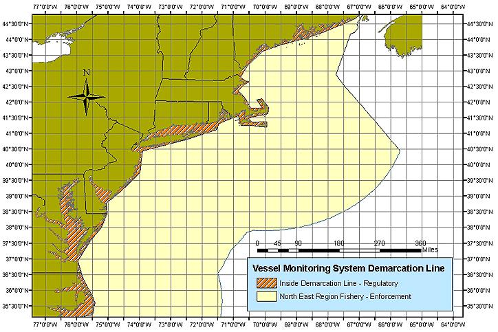
Northeast Region
This region consists of the Northeast Region includes marine waters off U.S. states of Maine, New Hampshire, Massachusetts, Rhode Island, Connecticut, New York, New Jersey, Pennsylvania, Delaware, Maryland, Virginia, North Carolina. Approximately 600 vessels are under VMS, with growth expected to 2500.
VMS is a basic tool in calculating DAS for the multispecies or DAS fisheries. Whenever a VMS fails to transmit an hourly function, it will be charged a DAS, unless the preponderance of evidence demonstrates that the failure to transmit was due to an unavoidable malfunction or disruption of the transmission, or was not at sea.
Fisheries of interest include:
- Scallop (dredge)
- Northeast multispecies (trawl, gillnet, hook gear)
- Monkfish (trawl, gillnet)
- Herring (trawl)
- Cod
Southeast Region
The Southeast Region includes marine waters off U.S. states of North Carolina, South Carolina, Georgia, Florida, Alabama, Mississippi, Louisiana, and Texas, as well as US waters around Puerto Rico and the US Virgin Islands.
Fisheries monitored by VMS
- Rock shrimp endorsement holders (trawl)
- Highly migratory species, or HMS (pelagic longline)
- Shark (gillnet and bottom longline gear)
- Penalty fleet (vessels subject to VMS monitoring as a penalty for violating fisheries regulations)
- Reef fish
269 vessels monitored by VMS
Skymate VMS is not approved for reef fish.
Northwest
The Northwest Region includes marine waters off U.S. states of Washington, Oregon and California.
- Rockfish Conservation Areas (RCAs): large-scale depth-based areas for stock preservation
- Cowcod Conservation Areas (CCAs): areas of previous overfishing
- Yelloweye Rockfish Conservation Area (YRCA): for another overfished species
The Pacific Coast vessel monitoring program consists of declaration reports and a vessel monitoring system. The declaration reports must be filed leaving port, and must identify:
- the vessel operator’s intent to fish within an RCA,
- the gear type will be used for fishing,
- the fishery they are participating in.
Declaration reports are only necessary for fisheries that are allowed within a closed area and before a vessel intends to fish.
Pacific Islands
Argos and Inmarsat-C are approved.
The Pacific Islands Region includes waters around U.S. islands of Hawaii, Guam, Northern Mariana Islands, American Samoa, Wake Island, Midway Island, Howland and Baker Islands, Kingman Reef and Palmyra Atoll, Johnston Island and Jarvis Island. Approximately 200 vessels have VMS.
- Pelagic longline
- Northwestern Hawaiian Islands lobster trap
- American Samoa alia (small vessel longline, pilot project)
- Tuna purse seine (operating under South Pacific Tuna Treaty)
- Krill trawl (operating under CCAMLR)
- Foreign longline, pole and line (operating according to terms of court-ordered settlement agreements resulting from violations of US fishery law)
Highly migratory species in multiple regions
The VMS for HMS consists of both the mobile transceiver unit placed on the vessel and the communications service provider that supplies the wireless link between the unit on the vessel and the shoreside data user.In the HMS Fisheries, the vessel owner is required to procure both VMS components. The two VMS components may, or may not, be provided by a single vendor. Thus, the vessel owner may need to procure the mobile transceiver unit and the mobile communications service separately.
VMS transmit vessel information primarily via INMARSAT satellites. They receive time and position data from the GPS constellation.
Uruguay
The authorities are theMaritime Authority, Dirección de Marina Mercante (DIMAR), and the Fishery Authority, Dirección Nacional de Recursos Pesqueros (DINARA).Uruguay licenses vessels for:
- Hake Merluccius hubbsi on the continental shelf of the Uruguayan-Argentine Common Fishing Zone in depth more than 50 meters
- white croaker Micropogonias furnieri and sea trout Cynoscion guatucupa, fishing in the coastal zone less than 50 meters depth in the La Plata River and the Uruguayan-Argentine common fishing zone
- Various vessels different from 1 and 2, that can fish in Uruguayan waters.
- Various vessels that fish in international waters. At present these vessels are fishing in FAO statistical area 41, CCAMLR 88.1 and 48.3, and the Pacific Ocean.
Main reference
- Nolan, Conor P. (Ed.) (1999) Proceedings of the International Conference on Integrated Fisheries Monitoring Sydney, Australia 1–5 February 1999. Originated by Fisheries and Aquaculture Department: FAOFãoFão is a town in Esposende Municipality in Portugal....
.