

Vermont Route 103
Encyclopedia
Vermont Route 103 is a north–south state highway
in southern Vermont
, United States
. It runs from Rockingham
in the east to Clarendon
near Rutland in the west. The Vermont Country Store
's second branch is one attraction along the route, as well as the Okemo Ski Resort
in Ludlow
.
for Vermont, being the most direct path from Boston
and southeastern New England to Rutland and the Green Mountains
ski areas and attractions. Although U.S. Route 4
is a shorter and slightly better road across the Green Mountains to Rutland, it is a direct east–west road intersecting Interstate 91
significantly north of the diagonal 103. Numerous proposals to widen 103 into a two-lane freeway
or similar limited-access roadway have failed, even though a substantial power company right of way shadows the road for much of its length.
just east of Interstate 91
and just north of Bellows Falls
. From there, it interchanges with I-91 at exit 6 and proceeds northeast to a pair of intersections with Meetinghouse Road, a loop road connecting VT 103 to the Rockingham Meetinghouse. Farther northwest, the route passes by one of Vermont Country Store
's two locations and intersects Williams Road and Lower Bartonsville Road, a pair of local roads leading to the Worrall Covered Bridge
and the Bartonsville Covered Bridge
, respectively. VT 103 continues as a wide sweeping road into Chester
, Windsor County, where it briefly overlaps VT 11
and crosses the Williams River
on a new bridge.
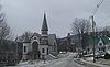 Just north of Chester, VT 103 passes through Stone Village, an area listed on the National Register of Historic Places
. Here, houses made of local granite
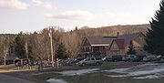
line both sides of VT 103. Outside of Stone Village, the road varies from a narrow and winding shoulder-less 2-lane between the river and mountains to a more wide-shouldered road. This variation remains until the village of Ludlow
, where the route passes by the Ludlow Baptist Church and the Black River Academy near the village green. A few blocks to the west, VT 103 intersects VT 100
and joins VT 100 north past the Okemo Ski Resort
into the town of Ludlow
, where the concurrency ends roughly 1 miles (2 km) north of the village. While VT 100 continues north and parallels the county line, VT 103 turns west and crosses into Rutland County.
, VT 103 passes within a few miles of the Crowley Cheese factory as it heads into the Shrewsbury
village of Cuttingsville with even more variations in road quality. Outside Cuttingsville, it proceeds through Clarendon
, where it crosses over the conjoined Long
and Appalachian Trail
s and intersects Airport and East Clarendon Roads, two local roadways leading, respectively, to the Kingsley
and Brown Covered Bridge
s. Shortly after the junction with East Clarendon Road, VT 103 intersects VT 7B, the former routing of U.S. Route 7, before terminating at modern US 7 adjacent to the Rutland Airport, just south of Rutland.
State highway
State highway, state road or state route can refer to one of three related concepts, two of them related to a state or provincial government in a country that is divided into states or provinces :#A...
in southern Vermont
Vermont
Vermont is a state in the New England region of the northeastern United States of America. The state ranks 43rd in land area, , and 45th in total area. Its population according to the 2010 census, 630,337, is the second smallest in the country, larger only than Wyoming. It is the only New England...
, United States
United States
The United States of America is a federal constitutional republic comprising fifty states and a federal district...
. It runs from Rockingham
Rockingham, Vermont
Rockingham is a town in Windham County, Vermont, United States, along the Connecticut River. The population was 5,309 at the 2000 census. Rockingham includes the incorporated villages of Bellows Falls and Saxtons River, as well as a large rural area west of Interstate 91.Rockingham has no formal...
in the east to Clarendon
Clarendon, Vermont
Clarendon is a town in Rutland County, Vermont, United States. The population was 2,571 at the 2010 census. Clarendon spans U.S. Route 7 and is split by the highway, the Cold River and Mill River, Otter Creek, and the Green Mountains into the villages of Clarendon, West Clarendon, East Clarendon,...
near Rutland in the west. The Vermont Country Store
Vermont Country Store
The Vermont Country Store, Inc. is an American catalogue, retail, and e-commerce business based in Vermont, with stores in Weston and Rockingham, company headquarters in Manchester, and a distribution facility and customer service center in North Clarendon, near Rutland...
's second branch is one attraction along the route, as well as the Okemo Ski Resort
Okemo Mountain
Okemo Mountain Resort is a ski resort located in Ludlow, Vermont. Before becoming a popular ski resort destination, Ludlow was originally a mill town, and was the home of a General Electric plant until 1977. The resort experienced 600,000 skier visits in 2009...
in Ludlow
Ludlow (town), Vermont
Ludlow is a town in Windsor County, Vermont, United States. The population was 2,449 at the 2000 census. Ludlow is the home of Okemo Mountain, a popular skiing area.-Geography:...
.
Route description
VT 103 is a major arterial roadArterial road
An arterial road, or arterial thoroughfare, is a high-capacity urban road. The primary function of an arterial road is to deliver traffic from collector roads to freeways, and between urban centres at the highest level of service possible. As such, many arteries are limited-access roads, or feature...
for Vermont, being the most direct path from Boston
Boston
Boston is the capital of and largest city in Massachusetts, and is one of the oldest cities in the United States. The largest city in New England, Boston is regarded as the unofficial "Capital of New England" for its economic and cultural impact on the entire New England region. The city proper had...
and southeastern New England to Rutland and the Green Mountains
Green Mountains
The Green Mountains are a mountain range in the U.S. state of Vermont. The range extends approximately .-Peaks:The most notable mountains in the range include:*Mount Mansfield, , the highest point in Vermont*Killington Peak, *Mount Ellen,...
ski areas and attractions. Although U.S. Route 4
U.S. Route 4
U.S. Route 4 is a long United States highway that runs from East Greenbush, New York, in the west to Portsmouth, New Hampshire, in the east, traversing through Vermont.In New York, US 4 is signed north–south to reflect its alignment in the state...
is a shorter and slightly better road across the Green Mountains to Rutland, it is a direct east–west road intersecting Interstate 91
Interstate 91
Interstate 91 is an Interstate Highway in the New England region of the United States. It provides the primary north–south thoroughfare in the western part of New England...
significantly north of the diagonal 103. Numerous proposals to widen 103 into a two-lane freeway
Two-lane freeway
A two-lane expressway is an expressway with only one lane in each direction, and usually no median barrier. It may be built that way because of constraints, or may be intended for expansion once traffic volumes rise. The term super two is often used by roadgeeks for this type of road, but traffic...
or similar limited-access roadway have failed, even though a substantial power company right of way shadows the road for much of its length.
Windham and Windsor Counties
VT 103 begins at U.S. Route 5 in RockinghamRockingham, Vermont
Rockingham is a town in Windham County, Vermont, United States, along the Connecticut River. The population was 5,309 at the 2000 census. Rockingham includes the incorporated villages of Bellows Falls and Saxtons River, as well as a large rural area west of Interstate 91.Rockingham has no formal...
just east of Interstate 91
Interstate 91
Interstate 91 is an Interstate Highway in the New England region of the United States. It provides the primary north–south thoroughfare in the western part of New England...
and just north of Bellows Falls
Bellows Falls, Vermont
Bellows Falls is an incorporated village located in the town of Rockingham in Windham County, Vermont, United States. The population was 3,165 at the 2000 census...
. From there, it interchanges with I-91 at exit 6 and proceeds northeast to a pair of intersections with Meetinghouse Road, a loop road connecting VT 103 to the Rockingham Meetinghouse. Farther northwest, the route passes by one of Vermont Country Store
Vermont Country Store
The Vermont Country Store, Inc. is an American catalogue, retail, and e-commerce business based in Vermont, with stores in Weston and Rockingham, company headquarters in Manchester, and a distribution facility and customer service center in North Clarendon, near Rutland...
's two locations and intersects Williams Road and Lower Bartonsville Road, a pair of local roads leading to the Worrall Covered Bridge
Worrall Covered Bridge
The Worrall Covered Bridge is a wooden covered bridge in Rockingham, Vermont, United States. Built in 1868 by Sanford Granger, the bridge is a lattice style with an 87 foot span across the Williams River...
and the Bartonsville Covered Bridge
Bartonsville Covered Bridge
The Bartonsville Covered Bridge was a wooden covered bridge in the village of Bartonsville, in Rockingham, Vermont, United States. Built in 1870 by Sanford Granger, the bridge was a lattice truss style with a 151 foot span across the Williams River...
, respectively. VT 103 continues as a wide sweeping road into Chester
Chester, Vermont
Chester is a town in Windsor County, Vermont, United States. The population was 3,044 at the 2000 census. The town was originally chartered by New Hampshire Governor Benning Wentworth as Flamstead in 1754. The terms of the charter were not met and the town was re-chartered as New Flamstead in 1761...
, Windsor County, where it briefly overlaps VT 11
Vermont Route 11
Vermont Route 11 is an east–west state highway in Vermont, United States. The western end of the highway is at Vermont Route 7A in Manchester. The eastern end is at the New Hampshire border at the Cheshire Bridge over the Connecticut River, connecting Springfield, Vermont and Charlestown, New...
and crosses the Williams River
Williams River (Vermont)
The Williams River is a river in the U.S. state of Vermont. It is a tributary of the Connecticut River. Its watershed covers 117 square miles; land use is about 80% forested and 4% agricultural, and the upper river supports wild brook trout and brown trout ....
on a new bridge.
National Register of Historic Places
The National Register of Historic Places is the United States government's official list of districts, sites, buildings, structures, and objects deemed worthy of preservation...
. Here, houses made of local granite
Granite
Granite is a common and widely occurring type of intrusive, felsic, igneous rock. Granite usually has a medium- to coarse-grained texture. Occasionally some individual crystals are larger than the groundmass, in which case the texture is known as porphyritic. A granitic rock with a porphyritic...
line both sides of VT 103. Outside of Stone Village, the road varies from a narrow and winding shoulder-less 2-lane between the river and mountains to a more wide-shouldered road. This variation remains until the village of Ludlow
Ludlow (village), Vermont
Ludlow is an incorporated village within the town of Ludlow, Windsor County, Vermont, United States. It is sometimes called Ludlow Village, to distinguish it from the surrounding town of the same name...
, where the route passes by the Ludlow Baptist Church and the Black River Academy near the village green. A few blocks to the west, VT 103 intersects VT 100
Vermont Route 100
Vermont Route 100 is a north–south state highway in Vermont, United States. Running through the center of the state, it travels nearly the entire length of Vermont and is long...
and joins VT 100 north past the Okemo Ski Resort
Okemo Mountain
Okemo Mountain Resort is a ski resort located in Ludlow, Vermont. Before becoming a popular ski resort destination, Ludlow was originally a mill town, and was the home of a General Electric plant until 1977. The resort experienced 600,000 skier visits in 2009...
into the town of Ludlow
Ludlow (town), Vermont
Ludlow is a town in Windsor County, Vermont, United States. The population was 2,449 at the 2000 census. Ludlow is the home of Okemo Mountain, a popular skiing area.-Geography:...
, where the concurrency ends roughly 1 miles (2 km) north of the village. While VT 100 continues north and parallels the county line, VT 103 turns west and crosses into Rutland County.
Rutland County
Across the county line in Mount HollyMount Holly, Vermont
Mount Holly is a town in Rutland County, Vermont, United States. The population was 1,237 at the 2010 census.-Geography:According to the United States Census Bureau, the town has a total area of , of which is land and , or 0.77%, is water.-Demographics:...
, VT 103 passes within a few miles of the Crowley Cheese factory as it heads into the Shrewsbury
Shrewsbury, Vermont
Shrewsbury is a town in Rutland County, Vermont, United States. The town was named for the Earl of Shrewsbury. The population was 1,056 at the 2010 census.Shrewsbury is the home of former U.S. Senator Jim Jeffords...
village of Cuttingsville with even more variations in road quality. Outside Cuttingsville, it proceeds through Clarendon
Clarendon, Vermont
Clarendon is a town in Rutland County, Vermont, United States. The population was 2,571 at the 2010 census. Clarendon spans U.S. Route 7 and is split by the highway, the Cold River and Mill River, Otter Creek, and the Green Mountains into the villages of Clarendon, West Clarendon, East Clarendon,...
, where it crosses over the conjoined Long
Long Trail
The Long Trail is a hiking trail located in Vermont, running the length of the state. It is the oldest long-distance trail in the United States, constructed between 1910 and 1930 by the Green Mountain Club...
and Appalachian Trail
Appalachian Trail
The Appalachian National Scenic Trail, generally known as the Appalachian Trail or simply the AT, is a marked hiking trail in the eastern United States extending between Springer Mountain in Georgia and Mount Katahdin in Maine. It is approximately long...
s and intersects Airport and East Clarendon Roads, two local roadways leading, respectively, to the Kingsley
Kingsley Covered Bridge
The Kingsley Covered Bridge is a wooden covered bridge in Clarendon, Vermont. Built in 1836 by Timothy K. Horton, the bridge is a town lattice style with a 120 foot span across the Mill River...
and Brown Covered Bridge
Brown Covered Bridge
The Brown Covered Bridge is a wooden covered bridge in Shrewsbury, Vermont. Built in 1880 by Nichols Powers, famed Vermont Bridgewright, also builder of Blenheim Bridge, recently lost to flooding in the aftermath of Tropical Storm Irene. Clarendon was the hometown of Mr...
s. Shortly after the junction with East Clarendon Road, VT 103 intersects VT 7B, the former routing of U.S. Route 7, before terminating at modern US 7 adjacent to the Rutland Airport, just south of Rutland.