

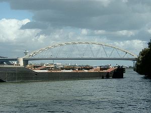
Van Brienenoordbrug
Encyclopedia
Arch bridge
An arch bridge is a bridge with abutments at each end shaped as a curved arch. Arch bridges work by transferring the weight of the bridge and its loads partially into a horizontal thrust restrained by the abutments at either side...
for car traffic over the river Nieuwe Maas
Nieuwe Maas
The Nieuwe Maas distributary of the Rhine River, and a former distributary of the Maas River, in the Dutch province of South Holland. It runs from the confluence of the rivers Noord and Lek, and flows west through Rotterdam. It ends west of the city where it meets the Oude Maas , near Vlaardingen,...
, which is a major distributary of the river Rhine. The bridge is located at the east side of Rotterdam
Rotterdam
Rotterdam is the second-largest city in the Netherlands and one of the largest ports in the world. Starting as a dam on the Rotte river, Rotterdam has grown into a major international commercial centre...
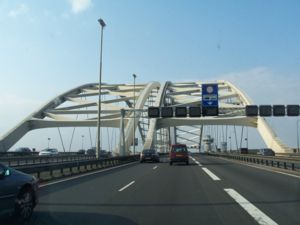
, The Netherlands. The bridge exists of two almost identical arches laying parallel and next to each other, followed by three bascule bridges. With over 250,000 vehicles every day the Van Brienenoordbrug, which is part of the A16
A16 motorway (Netherlands)
The A16 motorway is a motorway in the Netherlands. It runs from the interchange Terbregseplein in the northeastern part of Rotterdam, towards the Belgian border near Breda.- Speed limit :...
highway is the most busy road in the Netherlands. Bicycle riders can also use the bridges to cross the Nieuwe Maas river. The Van Brienenoordbrug is 1320 metres long and ships of 24 metres and lower are able to pass through underneath it.
The eastern arch was built in the early 1960s, the western (and slightly broader) one followed in 1990. The bridge is named after the underlying Eiland van Brienenoord (Island of Brienenoord) in the river, which was bought by and named after a baron Arnoud Willem van Brienen van de Groote Lindt in 1847. An oord is an area.
Boom barrier
A boom barrier is a bar, or pole pivoted in such a way as to allow the boom to block vehicular access through a controlled point. Typically the tip of a boom gate rises in a vertical arc to a near vertical position. Boom gates are often counterweighted, so the pole is easily tipped...
s. As of November 2005, the bridge is no longer controlled locally but from the nearby city of Rhoon
Rhoon
thumb|200px|Castle Rhoonthumb|200pxRhoon is a village that borders the municipality of the city of Rotterdam, South Holland, the Netherlands.According to its history it was established in 1199 and was ruled by the lords of Duiveland...
, where the regions Road Traffic Control is located.
Having the bridge opened for shipping needs to be requested at the harbor authorities, at least 3 hours in advance. Further action is undertaken by Road Traffic Control.
An electro-mechanical failure on 17 March 2006 left the bridge open for about an hour, on the middle of day, causing traffic jams up to 7 kilometres in length. The western bridge was closed first, restoring traffic to Breda
Breda
Breda is a municipality and a city in the southern part of the Netherlands. The name Breda derived from brede Aa and refers to the confluence of the rivers Mark and Aa. As a fortified city, the city was of strategic military and political significance...
. The eastern bridge was closed at approximatelly 1 o'clock AM, restoring traffic to The Hague
The Hague
The Hague is the capital city of the province of South Holland in the Netherlands. With a population of 500,000 inhabitants , it is the third largest city of the Netherlands, after Amsterdam and Rotterdam...
and Utrecht
Utrecht (city)
Utrecht city and municipality is the capital and most populous city of the Dutch province of Utrecht. It is located in the eastern corner of the Randstad conurbation, and is the fourth largest city of the Netherlands with a population of 312,634 on 1 Jan 2011.Utrecht's ancient city centre features...
. On 5 November 2006 failed to close again, this time due to an electrical failure, forcing engineers to close the bridge manually.