

Utah State Route 24
Encyclopedia
State Route 24 is a state highway
in south central Utah
which runs south from Salina
through Sevier County
then east through Wayne County
and north east through Emery County
. A portion of the highway has been designated the Capitol Reef Scenic Byway as part of the Utah Scenic Byways
program.
, taking a 160 miles (257.5 km) scenic route between the Fishlake
and Dixie National Forest
s then through Capitol Reef National Park
, along the eastern side of the San Rafael Reef
passing Goblin Valley State Park
and meeting I-70 again near Green River. Along the way it passes through the small towns of Loa
, Lyman
, Bicknell
, Torrey
and Hanksville
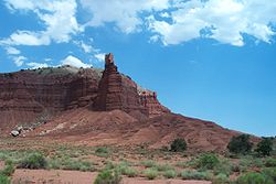
. The highway traverses an ever drier series of scenic areas starting in the west with the high, forested, mountains of Fishlake National Forest then the red cliffs of the Bicknell, Torrey area before winding through the spectacular Waterpocket Fold
in Capitol Reef N.P. to the much drier "moonscape" near Hanksville. The Mars Society
established the Mars Desert Research Station
just outside of Hanksville, due to its Mars-like terrain. The north easterly section past the San Rafael Reef is open desert with distant views of the Henry
and La Sal Mountains.
 The Average Daily Traffic (AADT) for SR-24 is at its greatest between Salina
and Sigurd
, where it varies between 3,085 down to 1,500 at the Junction with SR-118
. Past that point, the volume of traffic varies greatly, reaching peaks where the highway coincides with the main streets in the several towns through which it passes. In Loa
, the AADT reaches 2,080, in Torrey
, it peaks at 1,230. Then the traffic dies down to 295 by the time SR-24 arrives back at I-70.
southeast and east to Hanksville became a state highway in 1910 (Wayne County) and 1912 (Piute and Sevier Counties). The number was assigned in 1927 by the state legislature, and in 1935 it was extended northeast from Hanksville to US-6 near Green River. A realignment in 1961 bypassed Capitol Reef Road between Fruita
and Caineville; as part of the construction of I-70, the east end was moved west to that highway's exit 149 in 1964. SR-24 was extended north from its west end over former US-89 to present-day US-89 in 1969, and cut back slightly to its current end at US-50 in the 1977 renumbering. (The 1969 extension was signed as part of US-89 until 1992, soon after I-70 was completed.)
State highway
State highway, state road or state route can refer to one of three related concepts, two of them related to a state or provincial government in a country that is divided into states or provinces :#A...
in south central Utah
Utah
Utah is a state in the Western United States. It was the 45th state to join the Union, on January 4, 1896. Approximately 80% of Utah's 2,763,885 people live along the Wasatch Front, centering on Salt Lake City. This leaves vast expanses of the state nearly uninhabited, making the population the...
which runs south from Salina
Salina, Utah
Salina is a city in Sevier County, Utah, United States. The population was 2,393 at the 2000 census.-History:The first permanent settlers moved into the area in 1864 at the direction of leaders of the Church of Jesus Christ of Latter-day Saints...
through Sevier County
Sevier County, Utah
As of the census of 2000, there were 18,842 people, 6,081 households, and 4,907 families residing in the county. The population density was 10 people per square mile . There were 7,016 housing units at an average density of 4 per square mile...
then east through Wayne County
Wayne County, Utah
Wayne County is a county located in the U.S. state of Utah. It was formed from Piute County in 1892. The county gets its name from a man who served as delegate to the constitutional convention, in honor of his son who was dragged to death by a horse. As of 2000 the population was 2,509, and by...
and north east through Emery County
Emery County, Utah
Emery County is a county located in the U.S. state of Utah. As of 2000 the population was 10,860, and by 2009 had been estimated to decrease to 10,629. It was named for George W. Emery, governor of the Utah Territory in 1875...
. A portion of the highway has been designated the Capitol Reef Scenic Byway as part of the Utah Scenic Byways
Utah Scenic Byways
The legislature in the U.S. state of Utah has designated a system of Utah Scenic Byways in addition to the National Scenic Byways that are defined within the state. Some of the state designated routes overlap with the federal designations...
program.
Route description
The highway starts at US-50 near Salina and ends at I-70 near Green RiverGreen River, Utah
Green River is a city in Emery County, Utah, United States. The population was 973 at the 2000 census.-Geography:Green River is located at , on the banks of the Green River, after which the city is named. The San Rafael Swell region is to the west of Green River, while Canyonlands National Park...
, taking a 160 miles (257.5 km) scenic route between the Fishlake
Fishlake National Forest
Fishlake National Forest is located in south central Utah, USA. Its namesake is the largest freshwater mountain lake in the state.-Geography:...
and Dixie National Forest
Dixie National Forest
Dixie National Forest is a United States National Forest in Utah with headquarters in Cedar City. It occupies almost two million acres and stretches for about 170 miles across southern Utah. The largest national forest in Utah, it straddles the divide between the Great Basin and the Colorado River...
s then through Capitol Reef National Park
Capitol Reef National Park
Capitol Reef National Park is a United States National Park, in south-central Utah. It is 100 miles long but fairly narrow. The park, established in 1971, preserves 378 mi² and is open all year, although May through September are the most popular months.Called "Wayne Wonderland" in the 1920s...
, along the eastern side of the San Rafael Reef
San Rafael Reef
The San Rafael Reef is a geologic feature located in Emery County in central Utah, part of the Colorado Plateau. Approximately 75 miles long, it is the name given to the distinctive eastern edge of the San Rafael Swell...
passing Goblin Valley State Park
Goblin Valley State Park
Goblin Valley State Park is a state park of Utah, USA.Its eminent feature is its thousands of hoodoos and hoodoo rocks, which are formations of mushroom-shaped rock pinnacles, some as high as several meters...
and meeting I-70 again near Green River. Along the way it passes through the small towns of Loa
Loa, Utah
Loa is a town in, and the county seat of, Wayne County, Utah, United States, along State Route 24. The population was 525 at the 2000 census.-Geography:Loa is located at ....
, Lyman
Lyman, Utah
Lyman is a town along State Route 24 in Wayne County, Utah, United States. The population was 234 at the 2000 census.Lyman was originally known as East Loa...
, Bicknell
Bicknell, Utah
Bicknell is a town along State Route 24 in Wayne County, Utah, United States. As of the 2000 census, the town population was 353, a slight increase over the 1990 figure of 327.-History:...
, Torrey
Torrey, Utah
Torrey is a town located on State Route 24 in Wayne County, Utah, eight miles from Capitol Reef National Park. As of the 2000 census, the town had a total population of 171....
and Hanksville
Hanksville, Utah
Hanksville is a small town in Wayne County, Utah, United States, at the junction of State Routes 24 and 95. The town is just south of the confluence of the Fremont River and Muddy Creek, which together form the Dirty Devil River, which then flows southeast to the Colorado River...
. The highway traverses an ever drier series of scenic areas starting in the west with the high, forested, mountains of Fishlake National Forest then the red cliffs of the Bicknell, Torrey area before winding through the spectacular Waterpocket Fold
Waterpocket Fold
The Waterpocket Fold is a geologic landform that defines Capitol Reef National Park in the western United States. This monoclinal fold extends for slightly over 100 miles in the desert of central Utah. It can be seen via three scenic routes in the park. One route leads to a famous landmark known as...
in Capitol Reef N.P. to the much drier "moonscape" near Hanksville. The Mars Society
Mars Society
The Mars Society is an international space advocacy non-profit organization dedicated to promoting the human exploration and settlement of the planet Mars. It was founded by Robert Zubrin and others in 1998 and attracted the support of notable science fiction writers and filmmakers, including Kim...
established the Mars Desert Research Station
Mars Desert Research Station
The Mars Desert Research Station is the second of four planned simulated Mars surface exploration habitats owned and operated by the Mars Society.-Background:...
just outside of Hanksville, due to its Mars-like terrain. The north easterly section past the San Rafael Reef is open desert with distant views of the Henry
Henry Mountains
The Henry Mountains are located in the southeastern portion of the U.S. state of Utah and run in a generally north-south direction, extending over a distance of about 30 miles . They were named by John Wesley Powell in honour of Joseph Henry, the first secretary of the Smithsonian Institution. The...
and La Sal Mountains.
Traffic volume
Salina, Utah
Salina is a city in Sevier County, Utah, United States. The population was 2,393 at the 2000 census.-History:The first permanent settlers moved into the area in 1864 at the direction of leaders of the Church of Jesus Christ of Latter-day Saints...
and Sigurd
Sigurd, Utah
Sigurd is a town in Sevier County, Utah, United States. The population was 430 at the 2000 census.-Geography:Sigurd is located at ....
, where it varies between 3,085 down to 1,500 at the Junction with SR-118
Utah State Route 118
State Route 118 is a state highway in the U.S. state of Utah linking I-70/US-89 and Joseph to Richfield. The route is the main street for Joseph, Monroe and Richfield and spans . The highway was established 1931, initially connecting Joseph to Monroe and Central...
. Past that point, the volume of traffic varies greatly, reaching peaks where the highway coincides with the main streets in the several towns through which it passes. In Loa
Loa, Utah
Loa is a town in, and the county seat of, Wayne County, Utah, United States, along State Route 24. The population was 525 at the 2000 census.-Geography:Loa is located at ....
, the AADT reaches 2,080, in Torrey
Torrey, Utah
Torrey is a town located on State Route 24 in Wayne County, Utah, eight miles from Capitol Reef National Park. As of the 2000 census, the town had a total population of 171....
, it peaks at 1,230. Then the traffic dies down to 295 by the time SR-24 arrives back at I-70.
History
The road from SR-11 (by 1926 US-89) at SigurdSigurd, Utah
Sigurd is a town in Sevier County, Utah, United States. The population was 430 at the 2000 census.-Geography:Sigurd is located at ....
southeast and east to Hanksville became a state highway in 1910 (Wayne County) and 1912 (Piute and Sevier Counties). The number was assigned in 1927 by the state legislature, and in 1935 it was extended northeast from Hanksville to US-6 near Green River. A realignment in 1961 bypassed Capitol Reef Road between Fruita
Fruita, Utah
Fruita is the best-known settlement in Capitol Reef National Park in Wayne County, Utah, United States. It is located at the confluence of Fremont River and Sulphur Creek.-History:...
and Caineville; as part of the construction of I-70, the east end was moved west to that highway's exit 149 in 1964. SR-24 was extended north from its west end over former US-89 to present-day US-89 in 1969, and cut back slightly to its current end at US-50 in the 1977 renumbering. (The 1969 extension was signed as part of US-89 until 1992, soon after I-70 was completed.)