

Fishlake National Forest
Encyclopedia
Utah
Utah is a state in the Western United States. It was the 45th state to join the Union, on January 4, 1896. Approximately 80% of Utah's 2,763,885 people live along the Wasatch Front, centering on Salt Lake City. This leaves vast expanses of the state nearly uninhabited, making the population the...
, USA. Its namesake is the largest freshwater mountain lake in the state.
Geography
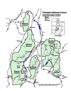
Established in 1907, the forest covers 1.5 million acres (6,070 km²) and is split into four districts. The forest lies in parts of nine counties. In descending order of forestland area they are SevierSevier County, Utah
As of the census of 2000, there were 18,842 people, 6,081 households, and 4,907 families residing in the county. The population density was 10 people per square mile . There were 7,016 housing units at an average density of 4 per square mile...
, Millard
Millard County, Utah
Millard County is a county located in the U.S. state of Utah. In 2010, its population was 12,420. It was named for Millard Fillmore, thirteenth President of the United States. Its county seat is Fillmore and the largest city is Delta.-Geography:...
, Piute
Piute County, Utah
Piute County is a county located in the U.S. state of Utah. The population in 2000 was 1,435, and by 2005 had been estimated to decrease to 1,365. It was named for the Paiute tribe of Native Americans. The county seat is Junction and the largest city is Circleville.-Geography:According to the U.S...
, Beaver
Beaver County, Utah
As of the census of 2010, there were 6,629 people, 2,265 households, and 1,697 families residing in the county. The population density was 2.56 people per square mile . There were 2,908 housing units at an average density of 1.12 per square mile...
, Wayne
Wayne County, Utah
Wayne County is a county located in the U.S. state of Utah. It was formed from Piute County in 1892. The county gets its name from a man who served as delegate to the constitutional convention, in honor of his son who was dragged to death by a horse. As of 2000 the population was 2,509, and by...
, Juab
Juab County, Utah
Juab County is a county located in the U.S. state of Utah. As of 2000 the population was 8,238, and by 2005 had been estimated at 9,113. It was named from an Indian word meaning thirsty valley, or possibly only valley. Its county seat and largest city is Nephi.Juab County is part of the...
, Garfield
Garfield County, Utah
Garfield County is a county located in the U.S. state of Utah. As of 2000 the population was 4,735. It was named for James A. Garfield, President of the United States in 1881. Its county seat and largest city is Panguitch.-Geography:...
, Iron
Iron County, Utah
As of the census of 2000, there were 33,779 people, 10,627 households, and 8,076 families residing in the county. The population density was 10 people per square mile . There were 13,618 housing units at an average density of 4 per square mile...
, and Sanpete
Sanpete County, Utah
Sanpete County is a county located in the U.S. state of Utah. The population according to the 2010 U.S. Census was 27,822. It was possibly named for a Ute Indian chief named Sanpitch, which was corrupted to Sanpete. Its county seat is Manti and its largest city is Ephraim.-Geography:According to...
counties. Forest headquarters are located in Richfield
Richfield, Utah
Richfield is a city in and the county seat of Sevier County, Utah, in the United States, and is the largest city in southern-central Utah. As of the 2010 census, the city population was 7,551. It lies in the Mormon Corridor, just off of Interstate 70 about 40 miles east of its junction with...
. There are local ranger
National Park Ranger
National Park Service Rangers are among the uniformed employees charged with protecting and preserving areas set aside in the National Park System by the United States Congress and/or the President of the United States...
district offices in Beaver
Beaver, Utah
Beaver is a city in Beaver County, Utah, United States. The population was 2,454 at the 2000 census. It is the county seat of Beaver County.Settled by Mormon pioneers in 1856, Beaver was one of a string of Mormon settlements extending the length of Utah...
, Fillmore
Fillmore, Utah
Fillmore is a city in Millard County, Utah, United States. The population was 2,253 at the 2000 census. It is the county seat of Millard County. It is named for the thirteenth US President Millard Fillmore....
, Loa
Loa, Utah
Loa is a town in, and the county seat of, Wayne County, Utah, United States, along State Route 24. The population was 525 at the 2000 census.-Geography:Loa is located at ....
, and Richfield. The national forest is the headwaters of Mammoth Creek
Mammoth Creek
Mammoth Creek is a Utah creek which flows for over 20 miles through mountains and forests from Mammoth Summit , through the Mammoth Valley, to its confluence with the Sevier River . The creek contains wild brown trout and hatchery rainbow trout.-External links:*...
, a tributary of the Sevier River
Sevier River
The Sevier River , extending , is the longest Utah river entirely in the state and drains an extended chain of mountain farming valleys to the intermittent Sevier Lake...
.
Acquisition
NativeIndigenous peoples of the Americas
The indigenous peoples of the Americas are the pre-Columbian inhabitants of North and South America, their descendants and other ethnic groups who are identified with those peoples. Indigenous peoples are known in Canada as Aboriginal peoples, and in the United States as Native Americans...
water rights to Fish Lake were sold to the Fremont Irrigation Company on March 10, 1889 for nine horses, 500 pounds of flour, one steer, and a suit of clothes. Ten years later President William McKinley
William McKinley
William McKinley, Jr. was the 25th President of the United States . He is best known for winning fiercely fought elections, while supporting the gold standard and high tariffs; he succeeded in forging a Republican coalition that for the most part dominated national politics until the 1930s...
created a Forest Reserve which included Fish Lake.
External links
Fishlake Scenic Byway