
Henry Mountains
Encyclopedia
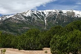
The Henry Mountains are located in the southeastern portion of the U.S. state of Utah
and run in a generally north-south direction, extending over a distance of about 30 miles (50 km). They were named by John Wesley Powell
in honour of Joseph Henry
, the first secretary of the Smithsonian Institution
. The nearest town of any size is Hanksville, Utah
, which is north of the mountains. The Henry Mountains were the last mountain range to be added to the map of the 48 contiguous U.S. states (1872), and before their official naming by Powell, were sometimes referred to as the "Unknown Mountains." In Navajo
, the range is still referred to as Dził Bizhiʼ Ádiní ("mountain whose name is missing").
 The range is clustered into two main groups, with Highway 276
dividing the two portions. The northern group is by far the taller of the two with Mount Ellen
: 11,506 feet above sea level; Mount Pennell: 11,371 feet; and Mount Hillers: 10,723 feet. The southern group is much lower in elevation. The southern group has two peaks: Mount Ellsworth: 8,235 feet and Mount Holmes
: 8,000 feet. The southern group is also known as the "Little Rockies".
The Henry Mountains are drained by a number of canyon systems which radiate away from the isolated range, flowing north into the Fremont River
, east into the Dirty Devil River
, or south into Lake Powell
.
The geology of these mountains was first studied in 1875-1876 by Grove Karl Gilbert
. He coined the term "laccolite" (now laccolith
) to describe the characteristic shapes of some of the igneous intrusions that core the mountains. The main type of igneous rock is porphyritic
diorite
.
Ages of the igneous rocks are important for understanding the evolution of the Colorado Plateau
. Ages of these rocks were reported to be about 45 to 50 million years in older geologic literature. However, it has been established that these intrusions formed in the period from about 23 to 31 million years ago, using uranium-lead dating
of zircon
and argon-argon dating
of hornblende
; fission track dating
also has yielded consistent results (the older, erroneous ages were by potassium-argon dating
). The intrusions are hosted by Permian
to Cretaceous
sedimentary rocks. The geology of these mountains is similar to the geology of the La Sal Range
and of the Abajo Mountains
, both also on the Colorado Plateau in southeastern Utah: locations are shown on a satellite image presented with information about the La Sal Range.
. The Henry Mountains Bison Herd
is believed to be one of only four free-roaming and genetically pure herds on public lands in North America. The other three herds are in Yellowstone National Park
, Wind Cave National Park
in South Dakota
and on Elk Island in Alberta, Canada.
The Henry Mountains Bison Herd
was created in 1941 when 18 bison, including three bulls, were moved from Yellowstone National Park and released near the Dirty Devil River
, south and east of Hanksville, Utah
. An additional five bulls were added to the population in 1942. The herd has gradually moved toward the Henry Mountains, frequenting elevations above 10,000 feet. The Henry Mountain herd has been brucellosis
-free since 1963.
A population objective of 325 bison by 2012 was set by Utah wildlife biologists for the Henry Mountain herd. To achieve this objective, and increase overall genetic diversity, breeding animals are being transplanted to other locations from the herd. In January, 2009, Utah Division of Wildlife Resources
officials transplanted 31 animals to the Book Cliffs
in eastern Utah. The new group joined 14 animals previously released in August, 2008 from a private herd on the nearby Uintah and Ouray Indian Reservation
. In addition, special licenses are issued annually to hunt the animals and help reduce the excess population. In 2009, 146 public once-in-a-lifetime Henry Mountain bison hunting permits were issued. This hunt is widely supported in the local area, as the remote, rugged terrain makes the bison difficult to hunt — providing business for local hunting guides.
Utah
Utah is a state in the Western United States. It was the 45th state to join the Union, on January 4, 1896. Approximately 80% of Utah's 2,763,885 people live along the Wasatch Front, centering on Salt Lake City. This leaves vast expanses of the state nearly uninhabited, making the population the...
and run in a generally north-south direction, extending over a distance of about 30 miles (50 km). They were named by John Wesley Powell
John Wesley Powell
John Wesley Powell was a U.S. soldier, geologist, explorer of the American West, and director of major scientific and cultural institutions...
in honour of Joseph Henry
Joseph Henry
Joseph Henry was an American scientist who served as the first Secretary of the Smithsonian Institution, as well as a founding member of the National Institute for the Promotion of Science, a precursor of the Smithsonian Institution. During his lifetime, he was highly regarded...
, the first secretary of the Smithsonian Institution
Smithsonian Institution
The Smithsonian Institution is an educational and research institute and associated museum complex, administered and funded by the government of the United States and by funds from its endowment, contributions, and profits from its retail operations, concessions, licensing activities, and magazines...
. The nearest town of any size is Hanksville, Utah
Hanksville, Utah
Hanksville is a small town in Wayne County, Utah, United States, at the junction of State Routes 24 and 95. The town is just south of the confluence of the Fremont River and Muddy Creek, which together form the Dirty Devil River, which then flows southeast to the Colorado River...
, which is north of the mountains. The Henry Mountains were the last mountain range to be added to the map of the 48 contiguous U.S. states (1872), and before their official naming by Powell, were sometimes referred to as the "Unknown Mountains." In Navajo
Navajo language
Navajo or Navaho is an Athabaskan language spoken in the southwestern United States. It is geographically and linguistically one of the Southern Athabaskan languages .Navajo has more speakers than any other Native American language north of the...
, the range is still referred to as Dził Bizhiʼ Ádiní ("mountain whose name is missing").
Geography and geology
State Route 276 (Utah)
State Route 276 is a state highway located in southwest-central San Juan, eastern Garfield, and a tiny portion of northeastern Kane counties, in the southeast of the U.S. state of Utah. The northern section was created in 1965 as an access road to Bullfrog Basin, while the southern section was...
dividing the two portions. The northern group is by far the taller of the two with Mount Ellen
Mount Ellen (Utah)
Mount Ellen is a mountain located in Garfield County, Utah. The high point of Mount Ellen's North Summit Ridge is the highest point in the Henry Mountains; it is also the highest point in Garfield County. It can be reached by a short hike from an unpaved road. These mountains were the last to be...
: 11,506 feet above sea level; Mount Pennell: 11,371 feet; and Mount Hillers: 10,723 feet. The southern group is much lower in elevation. The southern group has two peaks: Mount Ellsworth: 8,235 feet and Mount Holmes
Mount Holmes
Mount Holmes is a prominent mountain peak in Yellowstone National Park. It is the tallest mountain in the Wyoming portion of the Gallatin Range. Mount Holmes is located in the northwestern part of the park and marks the southern terminus of the Gallatin Range...
: 8,000 feet. The southern group is also known as the "Little Rockies".
The Henry Mountains are drained by a number of canyon systems which radiate away from the isolated range, flowing north into the Fremont River
Fremont River (Utah)
The Fremont River in Utah flows from the Johnson Valley Reservoir, which is located on the Wasatch Plateau near Fish Lake, southwest through Capitol Reef National Park to the Muddy Creek near Hanksville where the two rivers combine to form the Dirty Devil River, a tributary of the Colorado River...
, east into the Dirty Devil River
Dirty Devil River
The Dirty Devil River is a long tributary of the Colorado River, located in the U.S. state of Utah. It flows through southern Utah from the confluence of Fremont River and Muddy Creek to the Colorado River.-Course:...
, or south into Lake Powell
Lake Powell
Lake Powell is a huge reservoir on the Colorado River, straddling the border between Utah and Arizona . It is the second largest man-made reservoir in the United States behind Lake Mead, storing of water when full...
.
The geology of these mountains was first studied in 1875-1876 by Grove Karl Gilbert
Grove Karl Gilbert
Grove Karl Gilbert , known by the abbreviated name G. K. Gilbert in academic literature, was an American geologist....
. He coined the term "laccolite" (now laccolith
Laccolith
A laccolith is a sheet intrusion that has been injected between two layers of sedimentary rock. The pressure of the magma is high enough that the overlying strata are forced upward, giving the laccolith a dome or mushroom-like form with a generally planar base.Laccoliths tend to form at relatively...
) to describe the characteristic shapes of some of the igneous intrusions that core the mountains. The main type of igneous rock is porphyritic
Porphyritic
Porphyritic is an adjective used in geology, specifically for igneous rocks, for a rock that has a distinct difference in the size of the crystals, with at least one group of crystals obviously larger than another group...
diorite
Diorite
Diorite is a grey to dark grey intermediate intrusive igneous rock composed principally of plagioclase feldspar , biotite, hornblende, and/or pyroxene. It may contain small amounts of quartz, microcline and olivine. Zircon, apatite, sphene, magnetite, ilmenite and sulfides occur as accessory...
.
Ages of the igneous rocks are important for understanding the evolution of the Colorado Plateau
Colorado Plateau
The Colorado Plateau, also called the Colorado Plateau Province, is a physiographic region of the Intermontane Plateaus, roughly centered on the Four Corners region of the southwestern United States. The province covers an area of 337,000 km2 within western Colorado, northwestern New Mexico,...
. Ages of these rocks were reported to be about 45 to 50 million years in older geologic literature. However, it has been established that these intrusions formed in the period from about 23 to 31 million years ago, using uranium-lead dating
Uranium-lead dating
Uranium-lead is one of the oldest and most refined of the radiometric dating schemes, with a routine age range of about 1 million years to over 4.5 billion years, and with routine precisions in the 0.1-1 percent range...
of zircon
Zircon
Zircon is a mineral belonging to the group of nesosilicates. Its chemical name is zirconium silicate and its corresponding chemical formula is ZrSiO4. A common empirical formula showing some of the range of substitution in zircon is 1–x4x–y...
and argon-argon dating
Argon-argon dating
Argon-argon dating is a radiometric dating method invented to supersede potassium-argon dating in accuracy. The older method required two samples for dating while the newer method requires only one...
of hornblende
Hornblende
Hornblende is a complex inosilicate series of minerals .It is not a recognized mineral in its own right, but the name is used as a general or field term, to refer to a dark amphibole....
; fission track dating
Fission track dating
Fission track dating is a radiometric dating technique based on analyses of the damage trails, or tracks, left by fission fragments in certain uranium-bearing minerals and glasses...
also has yielded consistent results (the older, erroneous ages were by potassium-argon dating
Potassium-argon dating
Potassium–argon dating or K–Ar dating is a radiometric dating method used in geochronology and archeology. It is based on measurement of the product of the radioactive decay of an isotope of potassium into argon . Potassium is a common element found in many materials, such as micas, clay minerals,...
). The intrusions are hosted by Permian
Permian
The PermianThe term "Permian" was introduced into geology in 1841 by Sir Sir R. I. Murchison, president of the Geological Society of London, who identified typical strata in extensive Russian explorations undertaken with Edouard de Verneuil; Murchison asserted in 1841 that he named his "Permian...
to Cretaceous
Cretaceous
The Cretaceous , derived from the Latin "creta" , usually abbreviated K for its German translation Kreide , is a geologic period and system from circa to million years ago. In the geologic timescale, the Cretaceous follows the Jurassic period and is followed by the Paleogene period of the...
sedimentary rocks. The geology of these mountains is similar to the geology of the La Sal Range
La Sal Range
The La Sal Mountains are located in Grand and San Juan counties, near the eastern border of the state of Utah, and rising above the town of Moab. This range is part of the Manti-La Sal National Forest and the southern Rocky Mountains. The maximum elevation is at Mount Peale, reaching 12,721 feet ...
and of the Abajo Mountains
Abajo Mountains
The Abajo Mountains, also called the Blue Mountains, is a small mountain range west of Monticello, Utah, south of Canyonlands National Park and north of Blanding, Utah. The mountain range is located within the Manti-La Sal National Forest...
, both also on the Colorado Plateau in southeastern Utah: locations are shown on a satellite image presented with information about the La Sal Range.
American bison
The Henry Mountains are home to approximately 500 American bisonAmerican Bison
The American bison , also commonly known as the American buffalo, is a North American species of bison that once roamed the grasslands of North America in massive herds...
. The Henry Mountains Bison Herd
Henry Mountains Bison Herd
The Henry Mountains Bison Herd, numbering 250 to 400 bison, is believed to be one of only four free roaming and genetically pure herds on public lands in North America...
is believed to be one of only four free-roaming and genetically pure herds on public lands in North America. The other three herds are in Yellowstone National Park
Yellowstone National Park
Yellowstone National Park, established by the U.S. Congress and signed into law by President Ulysses S. Grant on March 1, 1872, is a national park located primarily in the U.S. state of Wyoming, although it also extends into Montana and Idaho...
, Wind Cave National Park
Wind Cave National Park
Wind Cave National Park is a United States national park north of the town of Hot Springs in western South Dakota. Established in 1903 by President Theodore Roosevelt, it was the seventh U.S. National Park and the first cave to be designated a national park anywhere in the world. The cave is...
in South Dakota
South Dakota
South Dakota is a state located in the Midwestern region of the United States. It is named after the Lakota and Dakota Sioux American Indian tribes. Once a part of Dakota Territory, South Dakota became a state on November 2, 1889. The state has an area of and an estimated population of just over...
and on Elk Island in Alberta, Canada.
The Henry Mountains Bison Herd
Henry Mountains Bison Herd
The Henry Mountains Bison Herd, numbering 250 to 400 bison, is believed to be one of only four free roaming and genetically pure herds on public lands in North America...
was created in 1941 when 18 bison, including three bulls, were moved from Yellowstone National Park and released near the Dirty Devil River
Dirty Devil River
The Dirty Devil River is a long tributary of the Colorado River, located in the U.S. state of Utah. It flows through southern Utah from the confluence of Fremont River and Muddy Creek to the Colorado River.-Course:...
, south and east of Hanksville, Utah
Hanksville, Utah
Hanksville is a small town in Wayne County, Utah, United States, at the junction of State Routes 24 and 95. The town is just south of the confluence of the Fremont River and Muddy Creek, which together form the Dirty Devil River, which then flows southeast to the Colorado River...
. An additional five bulls were added to the population in 1942. The herd has gradually moved toward the Henry Mountains, frequenting elevations above 10,000 feet. The Henry Mountain herd has been brucellosis
Brucellosis
Brucellosis, also called Bang's disease, Crimean fever, Gibraltar fever, Malta fever, Maltese fever, Mediterranean fever, rock fever, or undulant fever, is a highly contagious zoonosis caused by ingestion of unsterilized milk or meat from infected animals or close contact with their secretions...
-free since 1963.
A population objective of 325 bison by 2012 was set by Utah wildlife biologists for the Henry Mountain herd. To achieve this objective, and increase overall genetic diversity, breeding animals are being transplanted to other locations from the herd. In January, 2009, Utah Division of Wildlife Resources
Utah Division of Wildlife Resources
The Utah Division of Wildlife Resources is part of the Utah Department of Natural Resources for the state of Utah in the United States. The mission of the Division of Wildlife Resources is to serve the people of Utah as trustee and guardian of the state's wildlife, and to ensure its future and...
officials transplanted 31 animals to the Book Cliffs
Book Cliffs
The Book Cliffs are a series of mountains and cliffs in western Colorado and eastern Utah, in the western United States. They are so named because many of them have the triangular appearance of a book that has been opened up, then turned on its sides and set to rest on the open sides of the book,...
in eastern Utah. The new group joined 14 animals previously released in August, 2008 from a private herd on the nearby Uintah and Ouray Indian Reservation
Uintah and Ouray Indian Reservation
The Uintah and Ouray Indian Reservation is located in northeastern Utah, USA. It is the homeland of the Northern Ute Tribe, and is the largest of three Indian reservations inhabited by members of the Ute Tribe of Native Americans. It lies in parts of seven counties; in descending order of land area...
. In addition, special licenses are issued annually to hunt the animals and help reduce the excess population. In 2009, 146 public once-in-a-lifetime Henry Mountain bison hunting permits were issued. This hunt is widely supported in the local area, as the remote, rugged terrain makes the bison difficult to hunt — providing business for local hunting guides.
See also
- American BisonAmerican BisonThe American bison , also commonly known as the American buffalo, is a North American species of bison that once roamed the grasslands of North America in massive herds...
- Henry Mountains Bison HerdHenry Mountains Bison HerdThe Henry Mountains Bison Herd, numbering 250 to 400 bison, is believed to be one of only four free roaming and genetically pure herds on public lands in North America...
- Antelope Island Bison HerdAntelope Island Bison HerdAntelope Island in Great Salt Lake, Utah, United States of America is part of Antelope Island State Park. On the island, a semi-free ranging population of "Buffaloes" or American Bison have been in existence since 1893. Though the island was named for the Pronghorn Antelope that John C...
- Book CliffsBook CliffsThe Book Cliffs are a series of mountains and cliffs in western Colorado and eastern Utah, in the western United States. They are so named because many of them have the triangular appearance of a book that has been opened up, then turned on its sides and set to rest on the open sides of the book,...