

Uralla, New South Wales
Encyclopedia
Uralla is a small town and on the Northern Tablelands, New South Wales
, Australia
. The town is located at the intersection of the New England Highway
and Thunderbolts Way
465 kilometres north of Sydney
and about 23 kilometres south west of the city of Armidale
. At the 2006 census
, Uralla had a population of 2,267 people.
At more than 1000 metres above sea level, Uralla's high altitude makes for cold winters and mild summers.
an squatters from the language of the local Aniwan tribe of Indigenous Australians
. Uralla described a "meeting place", or more especially "a ceremonial meeting place and look-out on a hill".
Samuel McCrossin, an Irishman, his wife and seven children first came to Uralla in 1839 when they camped on the creek there. They returned to Morpeth
and then again returned to Uralla in 1841 to finally settle there. In the 1830s and 40s the land was occupied by squatters who had moved north beyond the limits of settlement. The squatters were attracted by the prime sheep grazing land of the New England Tableland. Some of these squatting runs were Kentucky
, Gostwyck, Balala, Yarrowyck
, Mihi Creek, Terrible Vale and Salisbury Court. Some of these station buildings, including Balala and the beautiful Gostwyck Chapel, have now been placed on the Register of the National Estate. Some of the land occupied by these squatters was made available to smaller farmers after the passing of the Robertson Land Acts
in 1861.
Uralla reached town status in 1855, spurred on by a gold rush
in the Rocky River
area three years earlier, swelling the town's size to over 5,000. In 1856 another and more considerable gold rush took place, but did not lead to any lasting development. By 1859 Uralla had three hotels, stores, a post office, a flour mill and a school. The Uralla Municipality was incorporated in 1882. In 1948, it became the administrative centre of the Uralla Shire after the municipality was merged with the former Gostwyck Shire. More gold was discovered and mined at Melrose in the Enmore area in about 1887. This discovery led to the erection of the Melrose public school and village, which was about 32 km east of Uralla. In 1927 this area was subdivided for soldier settlement, and ballots were held to determine the new settlers. In about 1889 gold was discovered at Groses Creek, which is 6 km southwest of Enmore, near the Mihi Falls on the eastern side of Uralla.
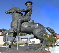
The infamous bushranger
Captain Thunderbolt
(Frederick Ward) is buried in the old Uralla Cemetery (John Street). There are many references to Thunderbolt throughout the town, and the locals are quite fond of the legend. In addition to an initially controversial statue in the main street, Uralla is host to a pub, motel, rock (from where Thunderbolt ambushed passing travellers) and roads, all bearing his name. On May 25, 1870, Thunderbolt was shot and killed near Uralla by Constable Alexander Walker during a highway robbery. However, a few Uralla locals claimed that it was his uncle, William (Harry) Ward - posing as Thunderbolt, who was killed at this time and not Fred Ward. The legend of Thunderbolt is exhibited at McCrossin's Mill Museum in Uralla and includes the series of 9 paintings by Phillip Pomroy of the events that led to Fred Ward's death.
 During 2008 Uralla recorded the state's highest rise in property values at 35 per cent over the last 12 months, according to a report from Australian Property Monitors.
manufacturing businesses. As Uralla is situated about halfway between Sydney and Brisbane, tourism contributes significantly to its economy, with a thriving village atmosphere and 20 National Parks
within a two hour drive. Due to Uralla's proximity to Armidale, larger shopping chains have avoided the small town and independent retailers remain. Examples include an antiquarian book store, numerous galleries, antique stores and cafes.
It is still possible to pan for gold in the rivers around the town, including the Rocky River. Today, the area is used for raising Merino
sheep and is renowned for its super-fine and ultra-fine wool
for use in the fashion industry. A number of vineyard
s have also been established and produce a variety of cool-climate wine
s. It is also a good area for growing apple
s and other fruit which require colder weather.
A wireless broadband trial in town using a tower on Mount Mutton has encouraged independent IT professionals to relocate to the area and form into a co-operative working arrangement named Granite Globe Incorporated. Lockheed Martin has erected a satellite tracking station at Uralla.
Uralla is also host to a thriving community of artists and potters, stimulated by proximity to the University of New England
in nearby Armidale
.
There are a number of environmental problems in the area, mainly caused by poor land management. Soil erosion, due to extensive logging and intensive farm practices is a major issue. Local government and community environmental bodies are now working to halt the problem.
It is served by the daily Countrylink
Xplorer service between Armidale
and Sydney
. The station is only 20 minutes from Armidale.
Northern Tablelands, New South Wales
The Northern Tablelands, also known as the New England Tableland, is a plateau and a region of the Great Dividing Range in northern New South Wales, Australia. It includes the New England Range, the narrow highlands area of the New England region, stretching from the Moonbi Range in the south to...
, Australia
Australia
Australia , officially the Commonwealth of Australia, is a country in the Southern Hemisphere comprising the mainland of the Australian continent, the island of Tasmania, and numerous smaller islands in the Indian and Pacific Oceans. It is the world's sixth-largest country by total area...
. The town is located at the intersection of the New England Highway
New England Highway
The New England Highway is a highway in Australia running from Hexham near Newcastle at its southern end to Yarraman near Toowoomba at its northern end. At its southern end it connects to the Pacific Highway and at its northern end it connects to the D'Aguilar Highway. It traverses the Hunter...
and Thunderbolts Way
Thunderbolts Way
Thunderbolts Way is a New South Wales country road linking Gloucester to Walcha , Uralla, where it very briefly joins the New England Highway and, to Copes Creek, south of the Gwydir Highway intersection at Inverell...
465 kilometres north of Sydney
Sydney
Sydney is the most populous city in Australia and the state capital of New South Wales. Sydney is located on Australia's south-east coast of the Tasman Sea. As of June 2010, the greater metropolitan area had an approximate population of 4.6 million people...
and about 23 kilometres south west of the city of Armidale
Armidale, New South Wales
Armidale is a city in the Northern Tablelands, New South Wales, Australia. Armidale Dumaresq Shire had a population of 19,485 people according to the 2006 census. It is the administrative centre for the Northern Tablelands region...
. At the 2006 census
Census in Australia
The Australian census is administered once every five years by the Australian Bureau of Statistics. The most recent census was conducted on 9 August 2011; the next will be conducted in 2016. Prior to the introduction of regular censuses in 1961, they had also been run in 1901, 1911, 1921, 1933,...
, Uralla had a population of 2,267 people.
At more than 1000 metres above sea level, Uralla's high altitude makes for cold winters and mild summers.
History
The word "Uralla" was taken by the EuropeEurope
Europe is, by convention, one of the world's seven continents. Comprising the westernmost peninsula of Eurasia, Europe is generally 'divided' from Asia to its east by the watershed divides of the Ural and Caucasus Mountains, the Ural River, the Caspian and Black Seas, and the waterways connecting...
an squatters from the language of the local Aniwan tribe of Indigenous Australians
Indigenous Australians
Indigenous Australians are the original inhabitants of the Australian continent and nearby islands. The Aboriginal Indigenous Australians migrated from the Indian continent around 75,000 to 100,000 years ago....
. Uralla described a "meeting place", or more especially "a ceremonial meeting place and look-out on a hill".
Samuel McCrossin, an Irishman, his wife and seven children first came to Uralla in 1839 when they camped on the creek there. They returned to Morpeth
Morpeth, New South Wales
Morpeth is a suburb of the City of Maitland Local Government Area in the Hunter Region of New South Wales, Australia. It is located on the southern banks of the Hunter River at the border between the City of Maitland and Port Stephens Council LGAs...
and then again returned to Uralla in 1841 to finally settle there. In the 1830s and 40s the land was occupied by squatters who had moved north beyond the limits of settlement. The squatters were attracted by the prime sheep grazing land of the New England Tableland. Some of these squatting runs were Kentucky
Kentucky, New South Wales
Kentucky is a village in the New England region of New South Wales, Australia. The village is situated about to the south of Uralla and to the north west of Walcha and approximately off the New England Highway. Kentucky is located by rail from Sydney in Sandon County on the Northern...
, Gostwyck, Balala, Yarrowyck
Yarrowyck, New South Wales
Yarrowyck is a rural locality on the western slopes of the Northern Tablelands, New South Wales, Australia.Yarrowyck is located in Uralla Shire and in Sandon County. The locality is about 23 kilometres north west of Uralla on Thunderbolts Way and about 31 kilometres west of the city of Armidale...
, Mihi Creek, Terrible Vale and Salisbury Court. Some of these station buildings, including Balala and the beautiful Gostwyck Chapel, have now been placed on the Register of the National Estate. Some of the land occupied by these squatters was made available to smaller farmers after the passing of the Robertson Land Acts
Robertson Land Acts
The Crown Lands Acts 1861 were introduced by the New South Wales Premier, John Robertson, in 1861 to reform land holdings and in particular to break the squatters' domination of land tenure...
in 1861.
Uralla reached town status in 1855, spurred on by a gold rush
Gold rush
A gold rush is a period of feverish migration of workers to an area that has had a dramatic discovery of gold. Major gold rushes took place in the 19th century in Australia, Brazil, Canada, South Africa, and the United States, while smaller gold rushes took place elsewhere.In the 19th and early...
in the Rocky River
Rocky River (New South Wales)
Rocky River is a locality in northern New South Wales, Australia near the town of Uralla on the Northern Tablelands plateau.About two kilometres west of Uralla, was the gold mining area and associated village also called Rocky River. In 1851 W.F. Buchanan and J. Lucas reported to the Maitland...
area three years earlier, swelling the town's size to over 5,000. In 1856 another and more considerable gold rush took place, but did not lead to any lasting development. By 1859 Uralla had three hotels, stores, a post office, a flour mill and a school. The Uralla Municipality was incorporated in 1882. In 1948, it became the administrative centre of the Uralla Shire after the municipality was merged with the former Gostwyck Shire. More gold was discovered and mined at Melrose in the Enmore area in about 1887. This discovery led to the erection of the Melrose public school and village, which was about 32 km east of Uralla. In 1927 this area was subdivided for soldier settlement, and ballots were held to determine the new settlers. In about 1889 gold was discovered at Groses Creek, which is 6 km southwest of Enmore, near the Mihi Falls on the eastern side of Uralla.
The infamous bushranger
Bushranger
Bushrangers, or bush rangers, originally referred to runaway convicts in the early years of the British settlement of Australia who had the survival skills necessary to use the Australian bush as a refuge to hide from the authorities...
Captain Thunderbolt
Captain Thunderbolt
Frederick Wordsworth Ward was an Australian bushranger renowned for escaping from Cockatoo Island, and also for his reputation as the "gentleman bushranger" and his lengthy survival, being the longest roaming bushranger in Australian history.-Early years:Frederick Ward was the son of convict...
(Frederick Ward) is buried in the old Uralla Cemetery (John Street). There are many references to Thunderbolt throughout the town, and the locals are quite fond of the legend. In addition to an initially controversial statue in the main street, Uralla is host to a pub, motel, rock (from where Thunderbolt ambushed passing travellers) and roads, all bearing his name. On May 25, 1870, Thunderbolt was shot and killed near Uralla by Constable Alexander Walker during a highway robbery. However, a few Uralla locals claimed that it was his uncle, William (Harry) Ward - posing as Thunderbolt, who was killed at this time and not Fred Ward. The legend of Thunderbolt is exhibited at McCrossin's Mill Museum in Uralla and includes the series of 9 paintings by Phillip Pomroy of the events that led to Fred Ward's death.
Industries
Three foundries account for a large amount of employment in the town, as do other metalMetal
A metal , is an element, compound, or alloy that is a good conductor of both electricity and heat. Metals are usually malleable and shiny, that is they reflect most of incident light...
manufacturing businesses. As Uralla is situated about halfway between Sydney and Brisbane, tourism contributes significantly to its economy, with a thriving village atmosphere and 20 National Parks
Protected areas of New South Wales
The Protected areas of New South Wales include both terrestrial and aquatic protected areas. At 30 June 2010 there were 776 separate terrestrial protected areas with a total land area of . 189 of these are national parks, totalling...
within a two hour drive. Due to Uralla's proximity to Armidale, larger shopping chains have avoided the small town and independent retailers remain. Examples include an antiquarian book store, numerous galleries, antique stores and cafes.
It is still possible to pan for gold in the rivers around the town, including the Rocky River. Today, the area is used for raising Merino
Merino
The Merino is an economically influential breed of sheep prized for its wool. Merinos are regarded as having some of the finest and softest wool of any sheep...
sheep and is renowned for its super-fine and ultra-fine wool
Wool
Wool is the textile fiber obtained from sheep and certain other animals, including cashmere from goats, mohair from goats, qiviut from muskoxen, vicuña, alpaca, camel from animals in the camel family, and angora from rabbits....
for use in the fashion industry. A number of vineyard
Vineyard
A vineyard is a plantation of grape-bearing vines, grown mainly for winemaking, but also raisins, table grapes and non-alcoholic grape juice...
s have also been established and produce a variety of cool-climate wine
Wine
Wine is an alcoholic beverage, made of fermented fruit juice, usually from grapes. The natural chemical balance of grapes lets them ferment without the addition of sugars, acids, enzymes, or other nutrients. Grape wine is produced by fermenting crushed grapes using various types of yeast. Yeast...
s. It is also a good area for growing apple
Apple
The apple is the pomaceous fruit of the apple tree, species Malus domestica in the rose family . It is one of the most widely cultivated tree fruits, and the most widely known of the many members of genus Malus that are used by humans. Apple grow on small, deciduous trees that blossom in the spring...
s and other fruit which require colder weather.
A wireless broadband trial in town using a tower on Mount Mutton has encouraged independent IT professionals to relocate to the area and form into a co-operative working arrangement named Granite Globe Incorporated. Lockheed Martin has erected a satellite tracking station at Uralla.
Uralla is also host to a thriving community of artists and potters, stimulated by proximity to the University of New England
University of New England, Australia
The University of New England is an Australian public university with approximately 18,000 higher education students. Its original and main campus is located in the city of Armidale in northern New South Wales....
in nearby Armidale
Armidale, New South Wales
Armidale is a city in the Northern Tablelands, New South Wales, Australia. Armidale Dumaresq Shire had a population of 19,485 people according to the 2006 census. It is the administrative centre for the Northern Tablelands region...
.
There are a number of environmental problems in the area, mainly caused by poor land management. Soil erosion, due to extensive logging and intensive farm practices is a major issue. Local government and community environmental bodies are now working to halt the problem.
It is served by the daily Countrylink
CountryLink
CountryLink is the operator of passenger rail services in country New South Wales, Australia and into Queensland and Victoria. It is an operating brand of the Rail Corporation New South Wales, a government-owned entity...
Xplorer service between Armidale
Armidale, New South Wales
Armidale is a city in the Northern Tablelands, New South Wales, Australia. Armidale Dumaresq Shire had a population of 19,485 people according to the 2006 census. It is the administrative centre for the Northern Tablelands region...
and Sydney
Sydney
Sydney is the most populous city in Australia and the state capital of New South Wales. Sydney is located on Australia's south-east coast of the Tasman Sea. As of June 2010, the greater metropolitan area had an approximate population of 4.6 million people...
. The station is only 20 minutes from Armidale.