
Yarrowyck, New South Wales
Encyclopedia
Yarrowyck is a rural locality on the western slopes of the Northern Tablelands, New South Wales
, Australia
.
Yarrowyck is located in Uralla Shire and in Sandon County. The locality is about 23 kilometres north west of Uralla
on Thunderbolts Way
and about 31 kilometres west of the city of Armidale
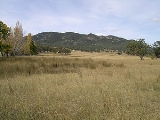
. Yarrowyck is an agricultural area with mostly sheep and beef cattle breeding and grazing activities in the valley of the Rocky River.
on the property Riverview. It is believed that about ten people were buried there but the headstones have now disappeared. The church hall was built c. 1910 and used for Protestant services and public meetings. The Yarrowyck region had a population of 136 people, (53.0% male, 47.0% female) in the 2006 census.
The Mount Yarrowyck Nature Reserve near the junction of the Armidale Road and Thunderbolts Way protects an Aboriginal
cave painting site and much of the natural environment of Mount Yarrowyck. The reserve's Aboriginal cultural walk, a three kilometre return track, will take you along the granite slopes of the mountain to the cave painting site.
The track will take you through one of the few remnants of natural bushland on the western slopes of the New England Tablelands. The walking track is clear and easy to follow and, apart from one short section, it is level and undemanding.
Northern Tablelands, New South Wales
The Northern Tablelands, also known as the New England Tableland, is a plateau and a region of the Great Dividing Range in northern New South Wales, Australia. It includes the New England Range, the narrow highlands area of the New England region, stretching from the Moonbi Range in the south to...
, Australia
Australia
Australia , officially the Commonwealth of Australia, is a country in the Southern Hemisphere comprising the mainland of the Australian continent, the island of Tasmania, and numerous smaller islands in the Indian and Pacific Oceans. It is the world's sixth-largest country by total area...
.
Yarrowyck is located in Uralla Shire and in Sandon County. The locality is about 23 kilometres north west of Uralla
Uralla, New South Wales
Uralla is a small town and on the Northern Tablelands, New South Wales, Australia. The town is located at the intersection of the New England Highway and Thunderbolts Way 465 kilometres north of Sydney and about 23 kilometres south west of the city of Armidale...
on Thunderbolts Way
Thunderbolts Way
Thunderbolts Way is a New South Wales country road linking Gloucester to Walcha , Uralla, where it very briefly joins the New England Highway and, to Copes Creek, south of the Gwydir Highway intersection at Inverell...
and about 31 kilometres west of the city of Armidale
Armidale, New South Wales
Armidale is a city in the Northern Tablelands, New South Wales, Australia. Armidale Dumaresq Shire had a population of 19,485 people according to the 2006 census. It is the administrative centre for the Northern Tablelands region...
. Yarrowyck is an agricultural area with mostly sheep and beef cattle breeding and grazing activities in the valley of the Rocky River.
History
Historically a small village, there are now only scattered agricultural properties, and a timber church that is now a private residence. There was a small cemetery located near the Gwydir RiverGwydir River
The Gwydir River is a large inland river in the northern part of the Australian state of New South Wales which is part of the Murray-Darling Basin. The river has two main tributaries—the Horton River and the Rocky River...
on the property Riverview. It is believed that about ten people were buried there but the headstones have now disappeared. The church hall was built c. 1910 and used for Protestant services and public meetings. The Yarrowyck region had a population of 136 people, (53.0% male, 47.0% female) in the 2006 census.
The Mount Yarrowyck Nature Reserve near the junction of the Armidale Road and Thunderbolts Way protects an Aboriginal
Indigenous Australians
Indigenous Australians are the original inhabitants of the Australian continent and nearby islands. The Aboriginal Indigenous Australians migrated from the Indian continent around 75,000 to 100,000 years ago....
cave painting site and much of the natural environment of Mount Yarrowyck. The reserve's Aboriginal cultural walk, a three kilometre return track, will take you along the granite slopes of the mountain to the cave painting site.
The track will take you through one of the few remnants of natural bushland on the western slopes of the New England Tablelands. The walking track is clear and easy to follow and, apart from one short section, it is level and undemanding.