

U.S. Route 67 in Iowa
Encyclopedia
U.S. Route 67 is a U.S. Highway in the state of Iowa
. The route begins in Davenport
at the Rock Island Centennial Bridge
where it crosses the Mississippi River
and ends at an intersection with US 52
and Iowa Highway 64 (Iowa 64) west of Sabula
. It passes through Bettendorf
, Le Claire
, and Clinton
. Except for Folletts
, every community which US 67 enters sits along the Mississippi River. As such, the entire route is part of the Great River Road
, an All-American Road.
US 67 was created in late 1934, when it replaced US 55
from Davenport to Dubuque
. The route ended then at the foot of the Julien Dubuque Bridge
, which carries US 20
. The northern half of the route, from Sabula to Dubuque, was overlapped by US 52
until 1967. Most of the routes that intersect US 67 do so within sight of their Mississippi River bridge crossing.
 US 67 crosses the Mississippi River
into Davenport
on the Rock Island Centennial Bridge
. Adjacent to the bridge is Modern Woodmen Park, home of the Midwest League's
Quad City River Bandits. Vehicles can continue to the north on Gaines Street, but US 67 traffic is forced to make a U-turn to the south to connect to River Drive. Prior to 2010, River Drive carried U.S. Route 61 (US 61), but the street now carries its business route. River Drive is prone to seasonal flooding from the Mississippi, as was the case in 1993, 1997, 2001, 2008, and 2011.
In downtown Davenport, US 61 Bus. intersects US 67 at two one-way streets, Harrison Street southbound and Brady Street northbound. Continuing east along the river, River Drive passes under the Government Bridge. It enters Bettendorf
and becomes two one-way streets, Grant Street southbound and State Street northbound. The two streets intersect Interstate 74 (I-74) and US 6
at the foot of the I-74 Bridge
s near downtown Bettendorf.
Through Bettendorf and Riverdale
, where the route turns to the northeast, US 67 is separated from the Mississippi riverfront by industry. Alcoa
, which employs over 2000 workers at its Davenport works, is the largest plant along US 67.
Just south of Le Claire
is the I-80 interchange, where US 67 passes underneath the Fred Schwengel Memorial Bridge
. In Le Claire the Mississippi River bends sharply and the highway follows. It heads through the picturesque downtown area, where many shops and even the street on which US 67 uses, Cody Road, pay homage to the Le Claire area's most famous son, Buffalo Bill Cody.
Between Le Claire and Princeton
, US 67 continues to closely parallel the river. This stretch of the road allows for good opportunities for bird watching. Where there are open views of the river, you can see water fowl on the water amongst lily pads. This area is near the southern end of the Upper Mississippi River National Wildlife and Fish Refuge.
North of Princeton, US 67 turns inland to cross the Wapsipinicon River
into Clinton County
. At Folletts
, the road takes a 90-degree turn back to the east towards Camanche
. It then runs parallel to the river, which is obscured by trees surrounding its backwaters. At Camanche, it passes around the city to the west and north. At Washington Boulevard, which is the former alignment of the route through Camanche, it turns to the north onto a four-lane, undivided highway, which passes an industrial area and over Union Pacific's Overland Route
. As it enters Clinton
, it joins with
US 30.
US 30 / US 67 head east along Lincoln Way through a industrial and retail area. As they continue east, the two routes split into one-way streets, northbound Liberty Avenue and southbound Camanche Avenue. The one-way street alignment ends at 11th Avenue South, but quickly begins again as US 30 / US 67 turn to the north onto northbound S. Third Street and southbound S. 4th Street. At 8th Avenue South, US 30 splits away from US 67 and onto the Gateway Bridge and crosses into Illinois
.
A block north, the one-way couplets rejoin and head a block east to S. 2nd Street. US 67 stays on 2nd Street for the next 2 miles (3.2 km). It passes through the heart of downtown Clinton, past the historic Van Allen Building
designed by Louis Sullivan
, Ashford University Field, home of the Clinton LumberKings
, also of the Midwest League, and passes the location of the failed Flav's Fried Chicken
restaurant. On the north end of Clinton, US 67 intercepts Iowa 136 at the foot of the Mark N. Norris Bridge to Fulton, Illinois
. The two routes are overlapped for 3/4 mi on 2nd Street and on Main Avenue. US 67 turns off of Main Avenue, away from Iowa 136 onto N. 3rd Street and continues north out of town.
North of Clinton, US 67 travels through rural areas for the remainder of its route. Surrounded by acres (hectares) of farmland, houses occasionally dot the route. Near the Clinton / Jackson
county line, the terrain begins to get hillier. The highway is entering the extreme southern end of the Driftless Area, a region of the Midwest
that avoided glaciation during the last Ice Age. West of Sabula
, US 67 meets Iowa 64. The US Highway merges onto the state highway, and the two routes head east together for 2/5 mi until they meet US 52. Iowa 64 continues eastward with US 52, but US 67 ends its journey from Texas here.
. It crossed the Mississippi River
over the Government Bridge with US 32 (now US 6). The highway followed roughly the same route it does today through the then-Tri Cities
, along the river to Clinton to its present end near Sabula. Instead of ending at US 52, the two routes continued north together
along the river through Bellevue
. Near Dubuque
, the two highways converged with two others: US 61 and US 151
. Closer to downtown Dubuque, where US 61 and US 151 diverged from US 52, US 67 ended and Iowa 3 began.
In 1940, US 67's entrance into Iowa was moved onto the new Rock Island Centennial Bridge
. The Centennial Bridge was a toll bridge from its opening on July 12, 1940, until May 3, 2003. Tolls were originally 10 cents (equivalent to $ in ) for drivers and 5 cents ($) for pedestrians. The pedestrian toll was ended in 1960. Tolls were 50 cents ($) when they were removed in 2003.
When the Julien Dubuque Bridge
was completed in 1943, US 67's northern end was moved to the intersection of Dodge Street, which carried US 20, and Locust Street, which carried US 67, US 52, US 61, and US 151. Iowa 3's eastern end was moved to the same intersection, but on the opposite side of the street from US 67's end. The intersection of Dodge and Locust was located at the foot of the Julien Dubuque Bridge.
When it was designated, US 67 only the first 45 miles (72.4 km), from Davenport to Almont, a ghost town in eastern Clinton County
, were paved. Within ten years, paving had extended north to Iowa 64. In addition, a short section north of Bellevue had been paved. By 1955, all 95 miles (152.9 km) were paved. In 1967, US 67 was truncated at the intersection of US 52 and Iowa 64.
Iowa
Iowa is a state located in the Midwestern United States, an area often referred to as the "American Heartland". It derives its name from the Ioway people, one of the many American Indian tribes that occupied the state at the time of European exploration. Iowa was a part of the French colony of New...
. The route begins in Davenport
Davenport, Iowa
Davenport is a city located along the Mississippi River in Scott County, Iowa, United States. Davenport is the county seat of and largest city in Scott County. Davenport was founded on May 14, 1836 by Antoine LeClaire and was named for his friend, George Davenport, a colonel during the Black Hawk...
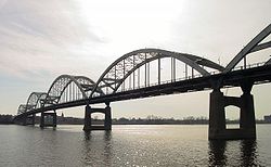
at the Rock Island Centennial Bridge
Rock Island Centennial Bridge
The Centennial Bridge, or Rock Island Centennial Bridge, connects Rock Island, Illinois and Davenport, Iowa. The bridge is long and stands above water level. On September 4, 1988, lights were installed on the arches, which make the bridge a very scenic sight at night.Construction of the bridge...
where it crosses the Mississippi River
Mississippi River
The Mississippi River is the largest river system in North America. Flowing entirely in the United States, this river rises in western Minnesota and meanders slowly southwards for to the Mississippi River Delta at the Gulf of Mexico. With its many tributaries, the Mississippi's watershed drains...
and ends at an intersection with US 52
U.S. Route 52 in Iowa
U.S. Route 52 is a long United States highway in northeast Iowa. The route begins at the Savanna–Sabula Bridge over the Mississippi River between Sabula and Savanna, Illinois. From Sabula, it heads north along the Mississippi towards Bellevue and Dubuque. At Dubuque, US 52 briefly...
and Iowa Highway 64 (Iowa 64) west of Sabula
Sabula, Iowa
Sabula is a city in Jackson County, Iowa, United States. The population was 670 at the 2000 census. Sabula is the site of Iowa's only island city. The island has a beach and a campground. It also has a harbor with boat docks and storage sheds to store some boats during the winter...
. It passes through Bettendorf
Bettendorf, Iowa
Bettendorf is a city in Scott County, Iowa, United States. Bettendorf is the fifteenth largest city in the U.S. state of Iowa and the fourth largest city in the "Quad Cities". As of the 2010 United States Census the population grew to 33,217. Bettendorf is one of the Quad Cities, along with...
, Le Claire
Le Claire, Iowa
Le Claire is a city in Scott County, Iowa, United States. The population was 3,765 in the 2010 census, an increase from 2,847 in the 2000 census. Le Claire is part of the Quad Cities Metropolitan Area.- History :...
, and Clinton
Clinton, Iowa
Clinton is a city in and the county seat of Clinton County, Iowa, United States. The population was 26231as of 2010. Clinton, along with DeWitt, Iowa , was named in honor of the seventh governor of New York, DeWitt Clinton. Clinton is the principal city of the Clinton Micropolitan Statistical...
. Except for Folletts
Folletts, Iowa
Folletts is an unincorporated community in Clinton County, Iowa, United States. It is located at the intersections of 292nd Street and County Highway Z36 on the north bank of the Wapsipinicon River. It is one mile west of Shaffton and three miles east of McCausland, at 41.750099N,...
, every community which US 67 enters sits along the Mississippi River. As such, the entire route is part of the Great River Road
Great River Road
The Great River Road is a collection of state, provincial, federal, and local roads which follow the course of the Mississippi River through ten states of the United States...
, an All-American Road.
US 67 was created in late 1934, when it replaced US 55
U.S. Route 55
U.S. Route 55 was a north–south United States highway. Despite the "5" in its route number, US 55 was never a long route. Though it was part of the original 1926 numbering plan, it was deleted within 10 years.-Route description:...
from Davenport to Dubuque
Dubuque, Iowa
Dubuque is a city in and the county seat of Dubuque County, Iowa, United States, located along the Mississippi River. In 2010 its population was 57,637, making it the ninth-largest city in the state and the county's population was 93,653....
. The route ended then at the foot of the Julien Dubuque Bridge
Julien Dubuque Bridge
The Julien Dubuque Bridge traverses the Mississippi River. It joins the cities of Dubuque, Iowa, and East Dubuque, Illinois. The bridge is part of the U.S. Highway 20 route...
, which carries US 20
U.S. Route 20 in Iowa
U.S. Route 20 in Iowa is a major east–west artery which runs across the state, separating the northern third of Iowa from the southern two-thirds. It enters Iowa from Nebraska, concurrent with Interstate 129 and U.S Route 75, crossing the Missouri River at Sioux City. US 20 runs in a...
. The northern half of the route, from Sabula to Dubuque, was overlapped by US 52
U.S. Route 52
U.S. Route 52 is a United States highway that runs across the northern, eastern and southeastern regions of the United States. Contrary to most other even-numbered U.S...
until 1967. Most of the routes that intersect US 67 do so within sight of their Mississippi River bridge crossing.
Route description
Mississippi River
The Mississippi River is the largest river system in North America. Flowing entirely in the United States, this river rises in western Minnesota and meanders slowly southwards for to the Mississippi River Delta at the Gulf of Mexico. With its many tributaries, the Mississippi's watershed drains...
into Davenport
Davenport, Iowa
Davenport is a city located along the Mississippi River in Scott County, Iowa, United States. Davenport is the county seat of and largest city in Scott County. Davenport was founded on May 14, 1836 by Antoine LeClaire and was named for his friend, George Davenport, a colonel during the Black Hawk...
on the Rock Island Centennial Bridge
Rock Island Centennial Bridge
The Centennial Bridge, or Rock Island Centennial Bridge, connects Rock Island, Illinois and Davenport, Iowa. The bridge is long and stands above water level. On September 4, 1988, lights were installed on the arches, which make the bridge a very scenic sight at night.Construction of the bridge...
. Adjacent to the bridge is Modern Woodmen Park, home of the Midwest League's
Midwest League
The Midwest League is a Class-A minor league baseball league which operates in the Midwestern United States.-History:Six teams – the Belleville Stags, the Centralia Cubs, the Marion Indians, the Mattoon Indians or East Frankfort White Sox, the Mount Vernon Braves, and the West Frankfort...
Quad City River Bandits. Vehicles can continue to the north on Gaines Street, but US 67 traffic is forced to make a U-turn to the south to connect to River Drive. Prior to 2010, River Drive carried U.S. Route 61 (US 61), but the street now carries its business route. River Drive is prone to seasonal flooding from the Mississippi, as was the case in 1993, 1997, 2001, 2008, and 2011.
In downtown Davenport, US 61 Bus. intersects US 67 at two one-way streets, Harrison Street southbound and Brady Street northbound. Continuing east along the river, River Drive passes under the Government Bridge. It enters Bettendorf
Bettendorf, Iowa
Bettendorf is a city in Scott County, Iowa, United States. Bettendorf is the fifteenth largest city in the U.S. state of Iowa and the fourth largest city in the "Quad Cities". As of the 2010 United States Census the population grew to 33,217. Bettendorf is one of the Quad Cities, along with...
and becomes two one-way streets, Grant Street southbound and State Street northbound. The two streets intersect Interstate 74 (I-74) and US 6
U.S. Route 6 in Iowa
U.S. Route 6 is an east–west U.S. highway which runs across the U.S. state of Iowa. It is signed in places as the Grand Army of the Republic Highway. Like all state highways in Iowa, it is maintained by the Iowa Department of Transportation. The route begins at the Missouri River...
at the foot of the I-74 Bridge
I-74 Bridge
The Interstate 74 Bridge, originally known as the Iowa-Illinois Memorial Bridge, and often called The Twin Bridges, or the I-74 Bridge, is a pair of suspension bridges that cross the Mississippi River and connect Bettendorf, Iowa and Moline, Illinois. It is located near the geographic center of...
s near downtown Bettendorf.
Through Bettendorf and Riverdale
Riverdale, Iowa
Riverdale is a city in Scott County, Iowa, United States. The population was 656 at the 2000 census.Alcoa has a giant aluminum rolling mill in Riverdale that employs about 2,000 people. The city site is surrounded on three sides by the far larger city of Bettendorf, and on the fourth by the...
, where the route turns to the northeast, US 67 is separated from the Mississippi riverfront by industry. Alcoa
Alcoa
Alcoa Inc. is the world's third largest producer of aluminum, behind Rio Tinto Alcan and Rusal. From its operational headquarters in Pittsburgh, Pennsylvania, Alcoa conducts operations in 31 countries...
, which employs over 2000 workers at its Davenport works, is the largest plant along US 67.
Just south of Le Claire
Le Claire, Iowa
Le Claire is a city in Scott County, Iowa, United States. The population was 3,765 in the 2010 census, an increase from 2,847 in the 2000 census. Le Claire is part of the Quad Cities Metropolitan Area.- History :...
is the I-80 interchange, where US 67 passes underneath the Fred Schwengel Memorial Bridge
Fred Schwengel Memorial Bridge
The Fred Schwengel Memorial Bridge is a 4-lane steel girder bridge that carries Interstate 80 across the Mississippi River between LeClaire, Iowa and Rapids City, Illinois. The bridge is named for Fred Schwengel, a former U.S. Representative from Davenport, Iowa and one of the driving forces behind...
. In Le Claire the Mississippi River bends sharply and the highway follows. It heads through the picturesque downtown area, where many shops and even the street on which US 67 uses, Cody Road, pay homage to the Le Claire area's most famous son, Buffalo Bill Cody.
Between Le Claire and Princeton
Princeton, Iowa
Princeton is a city in Scott County, Iowa, United States. The population was 946 at the 2000 census.-History:The first known settlers in Princeton Township were Giles M. and Haswell H. Pineo and Daniel Hire, about two years later...
, US 67 continues to closely parallel the river. This stretch of the road allows for good opportunities for bird watching. Where there are open views of the river, you can see water fowl on the water amongst lily pads. This area is near the southern end of the Upper Mississippi River National Wildlife and Fish Refuge.
North of Princeton, US 67 turns inland to cross the Wapsipinicon River
Wapsipinicon River
The Wapsipinicon River is a tributary of the Mississippi River, approximately long, in northeastern Iowa in the United States. It drains a rural farming region of rolling hills and bluffs north of Waterloo and Cedar Rapids. The initial vowel rhymes with "pop".It rises in Mower County, Minnesota...
into Clinton County
Clinton County, Iowa
-2010 census:The 2010 census recorded a population of 49,116 in the county, with a population density of . There were 21,733 housing units, of which 20,223 were occupied.-2000 census:...
. At Folletts
Folletts, Iowa
Folletts is an unincorporated community in Clinton County, Iowa, United States. It is located at the intersections of 292nd Street and County Highway Z36 on the north bank of the Wapsipinicon River. It is one mile west of Shaffton and three miles east of McCausland, at 41.750099N,...
, the road takes a 90-degree turn back to the east towards Camanche
Camanche, Iowa
Camanche is a city in Clinton County, Iowa, United States on the Mississippi River. The population was 4,215 at the 2000 census.-History:Camanche was founded by Dr. George Peck in the late 1830s, who is buried in the Rosehill Cemetery in Camanche....
. It then runs parallel to the river, which is obscured by trees surrounding its backwaters. At Camanche, it passes around the city to the west and north. At Washington Boulevard, which is the former alignment of the route through Camanche, it turns to the north onto a four-lane, undivided highway, which passes an industrial area and over Union Pacific's Overland Route
Overland Route (Union Pacific Railroad)
The Overland Route was a train route operated jointly by the Union Pacific Railroad and the Central Pacific Railroad / Southern Pacific Railroad, between Council Bluffs, Iowa / Omaha, Nebraska, and San Francisco, California over the grade of the First Transcontinental Railroad which had been...
. As it enters Clinton
Clinton, Iowa
Clinton is a city in and the county seat of Clinton County, Iowa, United States. The population was 26231as of 2010. Clinton, along with DeWitt, Iowa , was named in honor of the seventh governor of New York, DeWitt Clinton. Clinton is the principal city of the Clinton Micropolitan Statistical...
, it joins with
Concurrency (road)
A concurrency, overlap, or coincidence in a road network is an instance of one physical road bearing two or more different highway, motorway, or other route numbers...
US 30.
US 30 / US 67 head east along Lincoln Way through a industrial and retail area. As they continue east, the two routes split into one-way streets, northbound Liberty Avenue and southbound Camanche Avenue. The one-way street alignment ends at 11th Avenue South, but quickly begins again as US 30 / US 67 turn to the north onto northbound S. Third Street and southbound S. 4th Street. At 8th Avenue South, US 30 splits away from US 67 and onto the Gateway Bridge and crosses into Illinois
Illinois
Illinois is the fifth-most populous state of the United States of America, and is often noted for being a microcosm of the entire country. With Chicago in the northeast, small industrial cities and great agricultural productivity in central and northern Illinois, and natural resources like coal,...
.
A block north, the one-way couplets rejoin and head a block east to S. 2nd Street. US 67 stays on 2nd Street for the next 2 miles (3.2 km). It passes through the heart of downtown Clinton, past the historic Van Allen Building
Van Allen Building
The Van Allen Building, also known as Van Allen and Company Department Store, is a four story building in Clinton, Iowa designed by Louis Sullivan and commissioned by John Delbert Van Allen . Constructed 1912–1914 as a department store, it now has upper floor apartments with ground floor...
designed by Louis Sullivan
Louis Sullivan
Louis Henri Sullivan was an American architect, and has been called the "father of skyscrapers" and "father of modernism" He is considered by many as the creator of the modern skyscraper, was an influential architect and critic of the Chicago School, was a mentor to Frank Lloyd Wright, and an...
, Ashford University Field, home of the Clinton LumberKings
Clinton LumberKings
The Clinton LumberKings are a Midwest League Class A minor league baseball team based in Clinton, Iowa, USA, affiliated with the Seattle Mariners.-History:Clinton joined the Midwest League in 1954 and is the oldest franchise in the league...
, also of the Midwest League, and passes the location of the failed Flav's Fried Chicken
Flav's Fried Chicken
- FFC :In 2011, American hype man Flavor Flav partnered with Nick Cimino to open Flav’s Fried Chicken in Cimino's hometown of Clinton, Iowa. Flav met Cimino through his brother Peter, who runs Mama Cimino's in Las Vegas. After enjoying the rapper's homemade fried chicken, Peter Cimino began selling...
restaurant. On the north end of Clinton, US 67 intercepts Iowa 136 at the foot of the Mark N. Norris Bridge to Fulton, Illinois
Fulton, Illinois
Fulton is a city in Whiteside County, Illinois, United States. The population was 3,481 at the 2010 census, down from 3,881 at the 2000 census. Fulton is located across the Mississippi River from Clinton, Iowa.-Geography:...
. The two routes are overlapped for 3/4 mi on 2nd Street and on Main Avenue. US 67 turns off of Main Avenue, away from Iowa 136 onto N. 3rd Street and continues north out of town.
North of Clinton, US 67 travels through rural areas for the remainder of its route. Surrounded by acres (hectares) of farmland, houses occasionally dot the route. Near the Clinton / Jackson
Jackson County, Iowa
-2010 census:The 2010 census recorded a population of 19,848 in the county, with a population density of . There were 9,415 housing units, of which 8,289 were occupied.-2000 census:...
county line, the terrain begins to get hillier. The highway is entering the extreme southern end of the Driftless Area, a region of the Midwest
Midwestern United States
The Midwestern United States is one of the four U.S. geographic regions defined by the United States Census Bureau, providing an official definition of the American Midwest....
that avoided glaciation during the last Ice Age. West of Sabula
Sabula, Iowa
Sabula is a city in Jackson County, Iowa, United States. The population was 670 at the 2000 census. Sabula is the site of Iowa's only island city. The island has a beach and a campground. It also has a harbor with boat docks and storage sheds to store some boats during the winter...
, US 67 meets Iowa 64. The US Highway merges onto the state highway, and the two routes head east together for 2/5 mi until they meet US 52. Iowa 64 continues eastward with US 52, but US 67 ends its journey from Texas here.
History
U.S. Route 67 was extended into Iowa in late 1934, when it replaced the southernmost portion of US 55U.S. Route 55
U.S. Route 55 was a north–south United States highway. Despite the "5" in its route number, US 55 was never a long route. Though it was part of the original 1926 numbering plan, it was deleted within 10 years.-Route description:...
. It crossed the Mississippi River
Mississippi River
The Mississippi River is the largest river system in North America. Flowing entirely in the United States, this river rises in western Minnesota and meanders slowly southwards for to the Mississippi River Delta at the Gulf of Mexico. With its many tributaries, the Mississippi's watershed drains...
over the Government Bridge with US 32 (now US 6). The highway followed roughly the same route it does today through the then-Tri Cities
Quad Cities
The Quad Cities is a group of five cities straddling the Mississippi River on the Iowa–Illinois boundary. These cities, Davenport and Bettendorf and Rock Island, Moline, and East Moline , are the center of the Quad Cities Metropolitan Area, which, as of 2010, had an estimated population of...
, along the river to Clinton to its present end near Sabula. Instead of ending at US 52, the two routes continued north together
Concurrency (road)
A concurrency, overlap, or coincidence in a road network is an instance of one physical road bearing two or more different highway, motorway, or other route numbers...
along the river through Bellevue
Bellevue, Iowa
Bellevue is a city in Jackson County, Iowa, United States. The population was 2,350 at the 2000 census. The city lies along the Mississippi River , next to Bellevue State Park....
. Near Dubuque
Dubuque, Iowa
Dubuque is a city in and the county seat of Dubuque County, Iowa, United States, located along the Mississippi River. In 2010 its population was 57,637, making it the ninth-largest city in the state and the county's population was 93,653....
, the two highways converged with two others: US 61 and US 151
U.S. Route 151
U.S. Route 151 is a U.S. Highway that runs through the states of Iowa and Wisconsin. The southern terminus for U.S. 151 is at a junction with Interstate 80 in Iowa County, Iowa, and its northern terminus is at Manitowoc, Wisconsin. The route, from south to north follows a northeasterly path through...
. Closer to downtown Dubuque, where US 61 and US 151 diverged from US 52, US 67 ended and Iowa 3 began.
In 1940, US 67's entrance into Iowa was moved onto the new Rock Island Centennial Bridge
Rock Island Centennial Bridge
The Centennial Bridge, or Rock Island Centennial Bridge, connects Rock Island, Illinois and Davenport, Iowa. The bridge is long and stands above water level. On September 4, 1988, lights were installed on the arches, which make the bridge a very scenic sight at night.Construction of the bridge...
. The Centennial Bridge was a toll bridge from its opening on July 12, 1940, until May 3, 2003. Tolls were originally 10 cents (equivalent to $ in ) for drivers and 5 cents ($) for pedestrians. The pedestrian toll was ended in 1960. Tolls were 50 cents ($) when they were removed in 2003.
When the Julien Dubuque Bridge
Julien Dubuque Bridge
The Julien Dubuque Bridge traverses the Mississippi River. It joins the cities of Dubuque, Iowa, and East Dubuque, Illinois. The bridge is part of the U.S. Highway 20 route...
was completed in 1943, US 67's northern end was moved to the intersection of Dodge Street, which carried US 20, and Locust Street, which carried US 67, US 52, US 61, and US 151. Iowa 3's eastern end was moved to the same intersection, but on the opposite side of the street from US 67's end. The intersection of Dodge and Locust was located at the foot of the Julien Dubuque Bridge.
When it was designated, US 67 only the first 45 miles (72.4 km), from Davenport to Almont, a ghost town in eastern Clinton County
Clinton County, Iowa
-2010 census:The 2010 census recorded a population of 49,116 in the county, with a population density of . There were 21,733 housing units, of which 20,223 were occupied.-2000 census:...
, were paved. Within ten years, paving had extended north to Iowa 64. In addition, a short section north of Bellevue had been paved. By 1955, all 95 miles (152.9 km) were paved. In 1967, US 67 was truncated at the intersection of US 52 and Iowa 64.