

University Avenue (Minneapolis-St. Paul)
Encyclopedia
Minnesota
Minnesota is a U.S. state located in the Midwestern United States. The twelfth largest state of the U.S., it is the twenty-first most populous, with 5.3 million residents. Minnesota was carved out of the eastern half of the Minnesota Territory and admitted to the Union as the thirty-second state...
begins near the Minnesota State Capitol
Minnesota State Capitol
The Minnesota State Capitol is located in Minnesota's capital city, Saint Paul, and houses the Minnesota Senate, Minnesota House of Representatives, the Office of the Attorney General and the Office of the Governor...
in Saint Paul
Saint Paul, Minnesota
Saint Paul is the capital and second-most populous city of the U.S. state of Minnesota. The city lies mostly on the east bank of the Mississippi River in the area surrounding its point of confluence with the Minnesota River, and adjoins Minneapolis, the state's largest city...
and extends westward into neighboring Minneapolis
Minneapolis, Minnesota
Minneapolis , nicknamed "City of Lakes" and the "Mill City," is the county seat of Hennepin County, the largest city in the U.S. state of Minnesota, and the 48th largest in the United States...
, where it passes the University of Minnesota
University of Minnesota
The University of Minnesota, Twin Cities is a public research university located in Minneapolis and St. Paul, Minnesota, United States. It is the oldest and largest part of the University of Minnesota system and has the fourth-largest main campus student body in the United States, with 52,557...
, and then turns north to pass through several suburbs before ending in Blaine, Minnesota
Blaine, Minnesota
As of the census of 2000, there were 44,942 people, 15,898 households, and 12,177 families residing in the city. The population density is 1,330 people per square mile . There are 16,169 housing units at an average density of 477.6 per square mile...
. For many years, the road carried U.S. Highway 12
U.S. Route 12 in Minnesota
U.S. Route 12 is a highway in west-central and east-central Minnesota, which runs from the South Dakota state line at Ortonville near Big Stone Lake and continues east to the St. Croix River at the Wisconsin state line. U.S. 12 in Minnesota is in length...
and U.S. Highway 52
U.S. Route 52 in Minnesota
U.S. Highway 52 enters the state of Minnesota at the unincorporated community of Prosper, north of the town of Burr Oak, Iowa. The route is marked north–south in Minnesota along its independent segment from the Iowa state line to downtown St. Paul...
(at least for part of its length), and University Avenue is still a significant thoroughfare in the area. University Avenue's intersection with Snelling Avenue
Minnesota State Highway 51
Minnesota State Highway 51 is a highway in Minnesota, which runs from its intersection with State Highway 5 in Saint Paul and continues north to its northern terminus at its interchange with Interstate 694 / U.S. Highway 10 in Arden Hills. The route is in length.Highway 51 is also known as...
is Minnesota's busiest intersection with 64,000 cars passing through it daily. According to the Minnesota Department of Transportation the “busiest” intersection in Minnesota, as of 2009, was US Highway 169 and Co Rd 81.
University Avenue originally ran along a line several blocks north of its current location, forming a route which once connected the Minneapolis campus of the University of Minnesota
University of Minnesota
The University of Minnesota, Twin Cities is a public research university located in Minneapolis and St. Paul, Minnesota, United States. It is the oldest and largest part of the University of Minnesota system and has the fourth-largest main campus student body in the United States, with 52,557...
to Hamline University
Hamline University
-Red Wing location :Hamline was named in honor of Leonidas Lent Hamline, a bishop of the Methodist Church whose interest in the frontier led him to donate $25,000 toward the building of an institution of higher learning in what was then the territory of Minnesota. Today, a statue of Bishop Hamline...
in Saint Paul
Saint Paul, Minnesota
Saint Paul is the capital and second-most populous city of the U.S. state of Minnesota. The city lies mostly on the east bank of the Mississippi River in the area surrounding its point of confluence with the Minnesota River, and adjoins Minneapolis, the state's largest city...
(hence the name). When the construction of the Minnesota Transfer Railway
Minnesota Transfer Railway
The Minnesota Transfer Railway was a short line railroad in the United States.It was owned by nine major railroads serving the Twin Cities: the Chicago, Burlington and Quincy Railroad, the Chicago Great Western Railway, the Chicago, Milwaukee, St. Paul and Pacific Railroad, the Chicago, Rock...
yards blocked that route, the street was moved one-half mile to the south on the Saint Paul side, to what was then called Melrose Avenue. The old University Avenue route was renamed Minnehaha Avenue, which it remains to this day.
Some important neighborhoods the road passes through include Frogtown
Frogtown
Frogtown is a neighborhood in Saint Paul in the U.S. state of Minnesota. Built around University Avenue, the Thomas-Dale neighborhood is colloquially known as Frogtown . Historically, Frogtown was a subsection of the current Thomas-Dale neighborhood...
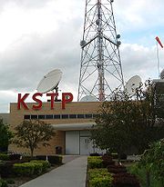
(officially, the Thomas-Dale neighborhood) and the Midway region, both in Saint Paul. Hubbard Broadcasting and its flagship stations, KSTP-AM-FM
KSTP-FM
KSTP-FM is a radio station serving the Minneapolis-St. Paul, Minnesota area. It is one of the flagship stations of Hubbard Broadcasting, which also owns several other TV and radio stations across the United States, along with other properties...
-TV
KSTP-TV
KSTP-TV, channel 5, is the ABC affiliate for the Twin Cities. Its transmitter is located at the Shoreview Telefarm. It is the flagship station of Hubbard Broadcasting, which also owns several other broadcasting properties across the United States....
, are located just next to the border of Minneapolis and Saint Paul. In fact, the sidewalk at the KSTP studios is right on the city/county line. This was one of the highest points in the area and made an appropriate site for a radio
Radio
Radio is the transmission of signals through free space by modulation of electromagnetic waves with frequencies below those of visible light. Electromagnetic radiation travels by means of oscillating electromagnetic fields that pass through the air and the vacuum of space...
transmitter
Transmitter
In electronics and telecommunications a transmitter or radio transmitter is an electronic device which, with the aid of an antenna, produces radio waves. The transmitter itself generates a radio frequency alternating current, which is applied to the antenna. When excited by this alternating...
. An antenna structure still stands there today, though it is used for microwave
Microwave
Microwaves, a subset of radio waves, have wavelengths ranging from as long as one meter to as short as one millimeter, or equivalently, with frequencies between 300 MHz and 300 GHz. This broad definition includes both UHF and EHF , and various sources use different boundaries...
links rather than broadcasting (KSTP and most other Twin Cities stations use the Telefarm installation in Shoreview, Minnesota
Shoreview, Minnesota
As of the census of 2000, there are 25,377 people, Males: 12,303 , Females: 13,074 , 9,965 households, and 7,021 families residing in the city. The population density is 2,315.9 people per square mile . There are 10,127 housing units at an average density of 919.2 per square mile...
or the nearby KMSP Tower
KMSP Tower
KMSP TV Tower is a 446.8 metre high guy-wired aerial mast for the transmission of FM radio and television programs in Shoreview, Minnesota at...
).
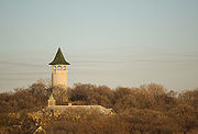
A water tower
Water tower
A water tower or elevated water tower is a large elevated drinking water storage container constructed to hold a water supply at a height sufficient to pressurize a water distribution system....
commonly known as the "Witch's Hat" stands just a few blocks away in Minneapolis's Prospect Park
Prospect Park, Minneapolis
Prospect Park is an historic neighborhood within the University community of the U.S. city of Minneapolis, Minnesota. The area is bounded by the Mississippi River to the south, the City of Saint Paul, Minnesota to the east, the Burlington Northern railroad yard to the north, and the Stadium...
neighborhood.
Washington Avenue (Minneapolis)
Washington Avenue is a major thoroughfare in Minneapolis, Minnesota. Starting north of Lowry Avenue, the street runs straight south, with Interstate 94 running alongside it until just south of West Broadway, when the freeway turns to the west...
in Minneapolis. History is being repeated, as the Green Line
Central Corridor (Minnesota)
The Central Corridor is a light rail line under construction that is to cover the stretch between the downtown regions of Minneapolis and Saint Paul in Minnesota...
light rail
Light rail
Light rail or light rail transit is a form of urban rail public transportation that generally has a lower capacity and lower speed than heavy rail and metro systems, but higher capacity and higher speed than traditional street-running tram systems...
is under construction which will connect the two downtowns as well as the University of Minnesota following a similar route.
University Avenue carries Ramsey County
Ramsey County, Minnesota
Ramsey County is a county located in the U.S. state of Minnesota, founded in 1849. As of 2010, the population was 508,640. Its county seat is St. Paul, which is also Minnesota's state capital. The county is named for Alexander Ramsey , the first governor of the Minnesota Territory...
Road 34 in Saint Paul, and Hennepin County
Hennepin County, Minnesota
Hennepin County is a county located in the U.S. state of Minnesota, named in honor of the 17th-century explorer Father Louis Hennepin. As of 2010 the population was 1,152,425. Its county seat is Minneapolis. It is by far the most populous county in Minnesota; more than one in five Minnesotans live...
Road 36 in Minneapolis to the junction with Interstate 35W
Interstate 35W
Interstate 35W may refer to:*Interstate 35W , an Interstate Highway serving Fort Worth, Texas, and its suburbs*Interstate 35W , a Interstate Highway serving Minneapolis, Minnesota, and its suburbs...
. West and north of Central Avenue
Minnesota State Highway 65
Minnesota State Highway 65 is a highway in east-central and northeast Minnesota, which runs from its intersection with Washington Avenue at the north end of downtown Minneapolis and continues north to its northern terminus at its intersection with U.S...
, University Avenue carries Minnesota State Highway 47
Minnesota State Highway 47
Minnesota State Highway 47 is a highway in east-central Minnesota, which runs from its intersection with Central Avenue in Minneapolis and continues north to its northern terminus at its intersection with U.S. Highway 169 in Aitkin....
to the junction with U.S. Route 10
U.S. Route 10
U.S. Route 10 is an east–west United States highway formed in 1926. Though it never became the cross-country highway suggested by the "0" as the last digit of its route number, U.S...
, after which it carries Anoka County
Anoka County, Minnesota
Anoka County is the fourth-most populous county in the U.S. state of Minnesota. The county is bordered by the counties of Isanti on the north, Chisago and Washington on the east, Hennepin and Ramsey on the south, Sherburne on the west, and the Mississippi River on the southwest.As of 2010, Anoka...
Road 51.