

U.S. Route 50 in Ohio
Encyclopedia
U.S. Route 50
runs east–west across the southern part of the U.S. state
of Ohio
, passing through Cincinnati, Chillicothe, and Athens. It is mainly a two-lane road except for the easternmost part. Near Athens it becomes part of State Route 32, a four-lane divided highway
known as Corridor D, and from Reedsville to the Ohio/West Virginia border it also overlaps State Route 7 before crossing into Parkersburg, West Virginia
.
near Lawrenceburg, immediately crossing under Interstate 275
before entering the extreme western suburbs of the greater Cincinnati area. US 50 (known in this area as River Road) follows the Ohio River
until entering the villages of Cleves
and North Bend
, where a monument and tomb of President William Henry Harrison
stands on the eastbound side of the road. In Cincinnati it is routed along the Sixth Street Expressway
, Fort Washington Way
, and the historic Columbia Parkway
(from which trucks are banned). In Fairfax, US 50 becomes known as Wooster Pike and crosses the Little Miami River
via the Wooster Pike Bridge in Milford. East of Milford, US 50 becomes a two-lane highway as it travels through Hillsboro
and Bainbridge
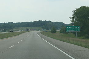
before reaching the outskirts of Chillicothe. In Chillicothe, US 50 becomes Western Avenue and then Main Street before merging with U.S. Route 23 and U.S. Route 35 east of the city. State Route 104 overlaps US 50 through downtown Chillicothe. As US 50 leaves Chillicothe it becomes a two-lane highway once again as it winds its way through McArthur
and heavy forested Southern Ohio before reaching the outskirts of Athens
where it becomes a four-lane highway. It will remain four-lane until reaching the Ohio River. US 50 joins with State Route 32 near the Ohio University
Bush Airport–Snyder Field
in Albany
, west of Athens. US 50 intersects with U.S. Route 33 east of the city before continuing eastward toward Belpre and the Ohio River
. US 50 begins to overlap SR 7 near Reedsville
as it heads north along the river, and splits from SR 7 before it crosses the river on the Blennerhassett Island Bridge
to Parkersburg, West Virginia.
U.S. Route 50
U.S. Route 50 is a major east–west route of the U.S. Highway system, stretching just over from Ocean City, Maryland on the Atlantic Ocean to West Sacramento, California. Until 1972, when it was replaced by Interstate Highways west of the Sacramento area, it extended to San Francisco, near...
runs east–west across the southern part of the U.S. state
U.S. state
A U.S. state is any one of the 50 federated states of the United States of America that share sovereignty with the federal government. Because of this shared sovereignty, an American is a citizen both of the federal entity and of his or her state of domicile. Four states use the official title of...
of Ohio
Ohio
Ohio is a Midwestern state in the United States. The 34th largest state by area in the U.S.,it is the 7th‑most populous with over 11.5 million residents, containing several major American cities and seven metropolitan areas with populations of 500,000 or more.The state's capital is Columbus...
, passing through Cincinnati, Chillicothe, and Athens. It is mainly a two-lane road except for the easternmost part. Near Athens it becomes part of State Route 32, a four-lane divided highway
Divided Highway
Divided Highway is a compilation album by American rock band The Doobie Brothers, released in 2003. . All tracks are taken from the albums Cycles and Brotherhood .-Track listing:...
known as Corridor D, and from Reedsville to the Ohio/West Virginia border it also overlaps State Route 7 before crossing into Parkersburg, West Virginia
Parkersburg, West Virginia
As of the census of 2000, there were 33,099 people, 14,467 households, and 8,767 families residing in the city. In 2006 the U.S. Census Bureau estimated that Parkersburg's population had decreased 4.4% to 31,755. The population density was 2,800.5 people per square mile . There were 16,100 housing...
.
Route description
US 50 enters Ohio from IndianaIndiana
Indiana is a US state, admitted to the United States as the 19th on December 11, 1816. It is located in the Midwestern United States and Great Lakes Region. With 6,483,802 residents, the state is ranked 15th in population and 16th in population density. Indiana is ranked 38th in land area and is...
near Lawrenceburg, immediately crossing under Interstate 275
Interstate 275 (Ohio)
Interstate 275 is an loop in Ohio, Indiana, and Kentucky that forms a complete beltway around the Cincinnati, Ohio area. It is the only auxiliary interstate that enters three states, including one state that the parent route does not enter . It is the longest loop interstate highway in the United...
before entering the extreme western suburbs of the greater Cincinnati area. US 50 (known in this area as River Road) follows the Ohio River
Ohio River
The Ohio River is the largest tributary, by volume, of the Mississippi River. At the confluence, the Ohio is even bigger than the Mississippi and, thus, is hydrologically the main stream of the whole river system, including the Allegheny River further upstream...
until entering the villages of Cleves
Cleves, Ohio
Cleves is a village, founded in 1818, along the Ohio River in western Hamilton County, Ohio, United States. The population was 2,790 at the 2000 census...
and North Bend
North Bend, Ohio
North Bend is a village in Hamilton County, Ohio, United States, along the Ohio River. The population was 603 at the 2000 census.-History:President Benjamin Harrison was born in North Bend. His grandfather, President William Henry Harrison is buried in the William Henry Harrison Tomb State...
, where a monument and tomb of President William Henry Harrison
William Henry Harrison
William Henry Harrison was the ninth President of the United States , an American military officer and politician, and the first president to die in office. He was 68 years, 23 days old when elected, the oldest president elected until Ronald Reagan in 1980, and last President to be born before the...
stands on the eastbound side of the road. In Cincinnati it is routed along the Sixth Street Expressway
Sixth Street Expressway
The Sixth Street Expressway is a six-lane urban controlled-access highway that runs from Interstate 75 in Queensgate, just west of downtown Cincinnati, Ohio, to the Waldvogel Viaduct, which continues to Lower Price Hill. The expressway opened to traffic in 1964, replacing Sixth Street for most of...
, Fort Washington Way
Fort Washington Way
Fort Washington Way is a one-mile section of freeway in downtown Cincinnati, Ohio. Running east-west in a trench, it carries Interstate 71 and US-50, first built between 1958 and 1961. It is named for a former fort which once stood nearby....
, and the historic Columbia Parkway
Columbia Parkway
Columbia Parkway is an expressway/parkway extending from Downtown Cincinnati, Ohio to the Village of Fairfax, and serving as US-50 on Cincinnati's east side. It was constructed in the Art Deco architectural style in 1938 as part of the New Deal...
(from which trucks are banned). In Fairfax, US 50 becomes known as Wooster Pike and crosses the Little Miami River
Little Miami River
The Little Miami River is a Class I tributary of the Ohio River that flows through five counties in southwestern Ohio in the United States. The Little Miami joins the Ohio River east of Cincinnati. It forms parts of the borders between Hamilton and Clermont counties and between Hamilton and Warren...
via the Wooster Pike Bridge in Milford. East of Milford, US 50 becomes a two-lane highway as it travels through Hillsboro
Hillsboro, Ohio
Hillsboro is a city in and the county seat of Highland County, Ohio, United States. The population was 6,605 at the 2010 census.-Geography:Hillsboro is located at ....
and Bainbridge
Bainbridge, Ross County, Ohio
Bainbridge is a village in Ross County, Ohio, United States, along Paint Creek. The population was 1,012 at the 2000 census.Bainbridge is the location of Pike Lake State Park...
before reaching the outskirts of Chillicothe. In Chillicothe, US 50 becomes Western Avenue and then Main Street before merging with U.S. Route 23 and U.S. Route 35 east of the city. State Route 104 overlaps US 50 through downtown Chillicothe. As US 50 leaves Chillicothe it becomes a two-lane highway once again as it winds its way through McArthur
McArthur, Ohio
McArthur is a village in Vinton County, Ohio, United States. The population was 1,888 at the 2000 census. It is the county seat of Vinton County.-Geography:McArthur is located at ....
and heavy forested Southern Ohio before reaching the outskirts of Athens
Athens, Ohio
Athens is the largest city in, and the county seat of, Athens County, Ohio, United States. It is located along the Hocking River in the southeastern part of Ohio. A historic college town, Athens is home to Ohio University and is the principal city of the Athens, Ohio Micropolitan Statistical Area. ...
where it becomes a four-lane highway. It will remain four-lane until reaching the Ohio River. US 50 joins with State Route 32 near the Ohio University
Ohio University
Ohio University is a public university located in the Midwestern United States in Athens, Ohio, situated on an campus...
Bush Airport–Snyder Field
Gordon K. Bush Airport
Ohio University Airport or Gordon K. Bush Airport , also known as Snyder Field, is a public-use airport located on State Route 32/U.S...
in Albany
Albany, Ohio
Albany is a village in Athens County, Ohio, United States. The population was 808 at the 2000 census.-Geography:Albany is located at ....
, west of Athens. US 50 intersects with U.S. Route 33 east of the city before continuing eastward toward Belpre and the Ohio River
Ohio River
The Ohio River is the largest tributary, by volume, of the Mississippi River. At the confluence, the Ohio is even bigger than the Mississippi and, thus, is hydrologically the main stream of the whole river system, including the Allegheny River further upstream...
. US 50 begins to overlap SR 7 near Reedsville
Reedsville, Ohio
Reedsville is an unincorporated community in eastern Olive Township, Meigs County, Ohio, United States. Although it is unincorporated, it has a post office, with the ZIP code of 45772.It lies along the Ohio River, below Hockingport and above Long Bottom....
as it heads north along the river, and splits from SR 7 before it crosses the river on the Blennerhassett Island Bridge
Blennerhassett Island Bridge
Blennerhassett Island Bridge opened to traffic June 13, 2008. The bridge is a Network Arch Bridge constructed at a cost of $120 million over the Ohio River between Belpre, Ohio and Parkersburg, West Virginia. Construction of the bridge was completed by the Walsh Construction Company of Chicago.The...
to Parkersburg, West Virginia.
Junction list
| County | Location | Mile | Destinations | Notes |
|---|---|---|---|---|
| Indiana Indiana Indiana is a US state, admitted to the United States as the 19th on December 11, 1816. It is located in the Midwestern United States and Great Lakes Region. With 6,483,802 residents, the state is ranked 15th in population and 16th in population density. Indiana is ranked 38th in land area and is... state line |
||||
| Hamilton Hamilton County, Ohio As of 2000, there were 845,303 people, 346,790 households, and 212,582 families residing in the county. The population density was 2,075 people per square mile . There were 373,393 housing units at an average density of 917 per square mile... |
Elizabethtown | 0.2 | No access | |
| Cleves Cleves, Ohio Cleves is a village, founded in 1818, along the Ohio River in western Hamilton County, Ohio, United States. The population was 2,790 at the 2000 census... |
3.7 | Southern terminus of OH-128 | ||
| 4.5 | Western terminus of OH-264 | |||
| Cincinnati Cincinnati, Ohio Cincinnati is a city in the U.S. state of Ohio. Cincinnati is the county seat of Hamilton County. Settled in 1788, the city is located to north of the Ohio River at the Ohio-Kentucky border, near Indiana. The population within city limits is 296,943 according to the 2010 census, making it Ohio's... |
18.6 | Western end of concurrency with OH-264 | ||
| 20.1 | Eastern end of concurrency with OH-264 Exit to US 27/42/52/127 |
|||
| 20.2 | , Lexington Lexington, Kentucky Lexington is the second-largest city in Kentucky and the 63rd largest in the US. Known as the "Thoroughbred City" and the "Horse Capital of the World", it is located in the heart of Kentucky's Bluegrass region... |
Western end of concurrency with I-71, I-71 exit 1G; I-71/I-75 N exit 1D; I-75 S exit 1G | ||
| 21.2 | Eastern end of concurrency with I-71, I-71 exit 1J | |||
| 21.8 | Newport Newport, Kentucky Newport is a city in Campbell County, Kentucky, United States, at the confluence of the Ohio and Licking rivers. The population was 15,273 at the 2010 census. Historically, it was one of four county seats of Campbell County. Newport is part of the Greater Cincinnati, Ohio Metro Area which... |
I-471 S only, I-471 exit 6A | ||
| 27.7 | Western termini of OH-32 and OH-125 Southern terminus of OH-561 |
|||
| Terrace Park Terrace Park, Ohio Terrace Park is a village in Hamilton County, Ohio, United States. It is a suburban village in Greater Cincinnati. The population was 2,273 at the 2000 census.-Geography:Terrace Park is located at .... |
36.1 | Eastern terminus of OH-126 | ||
| Clermont Clermont County, Ohio Clermont County is a county located in the state of Ohio, United States, just east of Cincinnati. As of 2010, the population was 197,363. Its county seat is Batavia... |
Milford Milford, Ohio Milford is a city in Clermont and Hamilton counties in the U.S. state of Ohio, along the Little Miami River in the southwestern part of the state. It is a part of Greater Cincinnati. Milford, an abbreviated form of mill ford, was so named because it was the first safe ford across the Little Miami... |
37.0 | Western terminus of OH-28 | |
| 37.7 | Western terminus of OH-131 | |||
| 39.2 | I-275 exit 59, via Milford Parkway | |||
| Stonelick | 43.7 | Northern terminus of OH-222 | ||
| Owensville Owensville, Ohio For communities with a similar name, see Owensville.Owensville is a village in Clermont County, Ohio, United States. The population was 816 at the 2000 census.-Geography:Owensville is located at .... |
46.9 | Western end of concurrency with OH-132 | ||
| 47.3 | Eastern end of concurrency with OH-132 Northern terminus of OH-276 |
|||
| Monterey | 51.0 | |||
| Marathon Marathon, Ohio Marathon is an unincorporated community in eastern Jackson Township, Clermont County, Ohio, United States. Although it is unincorporated, it has a post office, with the ZIP code of 45145. It lies along U.S. Route 50.-References:... |
54.3 | Western terminus of OH-286 | ||
| Brown Brown County, Ohio As of the census of 2000, there were 42,285 people, 15,555 households, and 11,790 families residing in the county. The population density was 86 people per square mile . There were 17,193 housing units at an average density of 35 per square mile... |
Vera Cruz | 57.4 | ||
| Fayetteville Fayetteville, Ohio Fayetteville is a village in Brown County, Ohio, United States. The population was 372 at the 2000 census.-Geography:Fayetteville is located at .... |
59.3 | |||
| St. Martin St. Martin, Ohio St. Martin was a village in Brown County, Ohio, United States. The population was 91 at the 2000 census. The community is served by the Fayetteville post office. St. Martin was dissolved as a village in November 2011 to be served by Perry Township.... |
61.3 | Southern terminus of OH-251 | ||
| Highland Highland County, Ohio As of the census of 2000, there were 40,875 people, 15,587 households, and 11,394 families residing in the county. The population density was 74 people per square mile . There were 17,583 housing units at an average density of 32 per square mile... |
Dodsonville | 65.7 | Western end of concurrency with OH-134 | |
| 65.8 | Eastern end of concurrency with OH-134 | |||
| Allenburg | 67.8 | Southern terminus of OH-135 | ||
| Hillsboro Hillsboro, Ohio Hillsboro is a city in and the county seat of Highland County, Ohio, United States. The population was 6,605 at the 2010 census.-Geography:Hillsboro is located at .... |
76.2 | Western end of concurrency with OH-124 | ||
| 76.7 | ||||
| 77.2 | Eastern end of concurrency with OH-124 | |||
| Rainsboro | 86.2 | Western end of concurrency with OH-753 | ||
| 87.1 | Eastern end of concurrency with OH-753 | |||
| Ross Ross County, Ohio As of the census of 2000, there were 73,345 people, 27,136 households, and 19,185 families residing in the county. The population density was 106 people per square mile . There were 29,461 housing units at an average density of 43 per square mile... |
Bainbridge Bainbridge, Ross County, Ohio Bainbridge is a village in Ross County, Ohio, United States, along Paint Creek. The population was 1,012 at the 2000 census.Bainbridge is the location of Pike Lake State Park... |
94.7 | Western end of concurrency with OH-41 | |
| 95.6 | Eastern end of concurrency with OH-41 | |||
| Slate Mills | 110.0 | Eastern terminus of OH-28 | ||
| Chillicothe Chillicothe, Ohio Chillicothe is a city in and the county seat of Ross County, Ohio, United States.Chillicothe was the first and third capital of Ohio and is located in southern Ohio along the Scioto River. The name comes from the Shawnee name Chalahgawtha, meaning "principal town", as it was a major settlement of... |
114.7 | Western end of concurrency with OH-104 | ||
| 115.0 | Northern terminus of OH-772 | |||
| 115.4 |     US 23 BUS/OH-104/OH-159 |
Eastern end of concurrency with OH-104; Southern terminus of OH-159 | ||
| 116.8 | Western end of concurrencies with US 23 and US 35; Interchange | |||
| 118.0 | Eastern end of concurrency with US 23 Interchange |
|||
| Schrader | 119.7 | Eastern end of concurrency with US 35 Interchange |
||
| Londonderry Londonderry, Ohio Londonderry is an unincorporated community in eastern Liberty Township, Ross County, Ohio, United States. Although it is unincorporated, it has a post office, with the ZIP code of 45647. It lies along U.S. Route 50 at its intersection with State Route 327.... |
127.2 | Western end of concurrency with OH-327 | ||
| Vinton Vinton County, Ohio Vinton County is a county located in the state of Ohio, United States. As of the 2010 census, the population was 13,435. , the least populous in the state. Its county seat is McArthur. The county is named for Samuel Finley Vinton, a 19th-century United States Congressman from... |
131.2 | Eastern end of concurrency with OH-327 | ||
| Ratcliffburg | 134.4 | Eastern terminus of OH-671 | ||
| Allensville | 139.9 | Northern terminus of OH-683 | ||
| McArthur McArthur, Ohio McArthur is a village in Vinton County, Ohio, United States. The population was 1,888 at the 2000 census. It is the county seat of Vinton County.-Geography:McArthur is located at .... |
146.7 | |||
| 149.3 | Southern terminus of OH-677 | |||
| Prattsville | 152.1 | Southern terminus of OH-278 | ||
| Bolins Mills | 157.9 | Southern terminus of OH-356 | ||
| Athens Athens County, Ohio As of the census of 2000, there were 62,223 people, 22,501 households, and 12,713 families residing in the county. The population density was 123 people per square mile . There were 24,901 housing units at an average density of 49 per square mile... |
Albany Albany, Ohio Albany is a village in Athens County, Ohio, United States. The population was 808 at the 2000 census.-Geography:Albany is located at .... |
160.2 | Northern terminus of OH-143 | |
| 161.1 | Western end of concurrency with OH-32 | |||
| 163.3 | ||||
| Athens Athens, Ohio Athens is the largest city in, and the county seat of, Athens County, Ohio, United States. It is located along the Hocking River in the southeastern part of Ohio. A historic college town, Athens is home to Ohio University and is the principal city of the Athens, Ohio Micropolitan Statistical Area. ... |
171.2 | , Ravenswood Ravenswood, West Virginia Ravenswood is a city in Jackson County, West Virginia, United States, along the Ohio River. The population was 4,031 at the 2000 census.-Geography:Ravenswood is located at , along the Ohio River at the mouth of Sandy Creek.... |
Western end of concurrency with US 33; Exit 18 | |
| 172.1 | Southern terminus of OH-681; Exit 17 | |||
| 173.7 | Eastern end of concurrency with US 33; Exit 16 | |||
| Canaanville Canaanville, Ohio Canaanville is an unincorporated community in Athens County, Ohio, United States. It has an elevation of and is located at .According to the Centennial Atlas of Athens County , the community originally called Canaanville was slightly to the west, west of where Ohio State Route 690 now intersects... |
178.7 | Southern terminus of OH-690 | ||
| Guysville Guysville, Ohio Guysville is an unincorporated community in southern Rome Township, Athens County, Ohio, United States. Although it is unincorporated, it has a post office, with the ZIP code of 45735.The town is located on the Hocking River at the junction of U.S... |
183.3 | Southern terminus of OH-329 | ||
| Coolville Coolville, Ohio Not to be confused with Coolsville, Ohio, a fictional city in the cartoon series Scooby Doo.Coolville is a village located in Troy Township, Athens County, Ohio, United States, in the extreme southeast of the state... |
192.7 | Western end of concurrency with OH-7 Interchange |
||
| 194.2 | ||||
| Washington Washington County, Ohio Washington County is a county located in the state of Ohio. As of the 2010 census, the population was 61,778. Its county seat is Marietta. The county, the oldest in the state, is named for George Washington. Washington County is included in the Parkersburg-Marietta-Vienna, West Virginia-Ohio... |
Little Hocking Little Hocking, Ohio Little Hocking is a census-designated place in southern Belpre Township, Washington County, Ohio, United States. Although it is unincorporated, it has a post office, with the ZIP code of 45742.... |
200.5 | Eastern terminus of OH-124 | |
| Redbush | 201.0 | Southern terminus of OH-555 | ||
| Porterfield | 202.4 | Western terminus of OH-618 | ||
| 203.3 | Interchange | |||
| 203.9 | Eastern end of concurrencies with OH-7 and OH-32 Interchange |
|||
| 204.2 | ||||
| Blennerhassett Island Bridge Blennerhassett Island Bridge Blennerhassett Island Bridge opened to traffic June 13, 2008. The bridge is a Network Arch Bridge constructed at a cost of $120 million over the Ohio River between Belpre, Ohio and Parkersburg, West Virginia. Construction of the bridge was completed by the Walsh Construction Company of Chicago.The... , West Virginia West Virginia West Virginia is a state in the Appalachian and Southeastern regions of the United States, bordered by Virginia to the southeast, Kentucky to the southwest, Ohio to the northwest, Pennsylvania to the northeast and Maryland to the east... state line |
||||