
Tyrolean Aerial Tramway
Encyclopedia
| Tyrolean Zugspitze Cable Car Tiroler Zugspitzbahn |
|
|---|---|
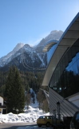
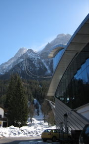
| Location: | Ehrwald Ehrwald Ehrwald is a municipality in the Austrian district of Reutte, Tyrol.Ehrwald lies at the southern base of the Zugspitze , Germany's highest mountain, but which is shared with Austria. The town is connected to the Zugspitze with the Tyrolean Aerial Tramway .-References:... -Zugspitze Zugspitze The Zugspitze, at 2,962 metres above sea level, is the highest peak of the Wetterstein Mountains as well as the highest mountain in Germany. It lies south of the town of Garmisch-Partenkirchen, and the border between Germany and Austria runs over its western summit. South of the mountain is... ,  Tyrol (state) Tyrol (state) |
| Mountainrange: | Wetterstein Wetterstein The Wetterstein, is a mountain range in the Northern Limestone Alps. It is a compact range between Garmisch-Partenkirchen, Mittenwald, Seefeld in Tirol and Ehrwald; partially in Bavaria, Germany and partially in Tyrol, Austria... , Alps Alps The Alps is one of the great mountain range systems of Europe, stretching from Austria and Slovenia in the east through Italy, Switzerland, Liechtenstein and Germany to France in the west.... |
| Track length: | 3600 m |
| Elevation: | 1725 m 1225 m  2950 m 2950 m |
| Trip | |
| Duration: | 10 Minutes |
| Velocity: | 36 km/h |
| Background | |
| Owner: | Zillertaler Gletscherbahn |
| Opening: | July 1926 (Renovation July 1991) |
| Contact: | zugspitzbahn.at |
Austria
Austria , officially the Republic of Austria , is a landlocked country of roughly 8.4 million people in Central Europe. It is bordered by the Czech Republic and Germany to the north, Slovakia and Hungary to the east, Slovenia and Italy to the south, and Switzerland and Liechtenstein to the...
n town of Ehrwald
Ehrwald
Ehrwald is a municipality in the Austrian district of Reutte, Tyrol.Ehrwald lies at the southern base of the Zugspitze , Germany's highest mountain, but which is shared with Austria. The town is connected to the Zugspitze with the Tyrolean Aerial Tramway .-References:...
(1225 metres above sea level
Sea level
Mean sea level is a measure of the average height of the ocean's surface ; used as a standard in reckoning land elevation...
) with the top station at 2950 metres above sea level
Sea level
Mean sea level is a measure of the average height of the ocean's surface ; used as a standard in reckoning land elevation...
next to the summit of Zugspitze
Zugspitze
The Zugspitze, at 2,962 metres above sea level, is the highest peak of the Wetterstein Mountains as well as the highest mountain in Germany. It lies south of the town of Garmisch-Partenkirchen, and the border between Germany and Austria runs over its western summit. South of the mountain is...
, Germany
Germany
Germany , officially the Federal Republic of Germany , is a federal parliamentary republic in Europe. The country consists of 16 states while the capital and largest city is Berlin. Germany covers an area of 357,021 km2 and has a largely temperate seasonal climate...
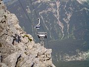
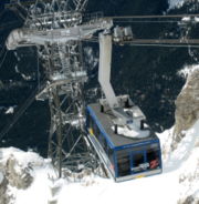
's highest mountain on the border of Austria. The top station is opposite to the top station of the German Eibsee Cable Car. It has a length of 3600 metres and an elevation gain of 1725 metres. The Tyrolean Zugspitze Cable Car runs over three aerial lift pylons. The double track ropes have a diameter of 62 mm each, and the hauling rope has a diameter of 38 mm. It runs on 2 x 500 kilowatts of power, generated in the valley station. The journey normally takes less than 10 minutes at a speed of 36 km/h. The tramway's two cabins can accommodate 100 persons each and have a transport capacity of 730 persons per hour each way.
There is a cable lift from Ehrwald to the base of Zugspitze in Austria where the resort Ehrwald Alm houses skiers, and a ski run down to Ehrwald starts. The resort has a dramatic view of the face of Zugspitze.
Literature
- Wunder der Technik – Tiroler Zugspitzbahn. Die Geschichte der ersten Seilbahn Tirols. Herausgegeben von der Zillertaler Gletscherbahn GmbH&Co KG, Innsbruck 2006