
.gif)
Typhoon Dianmu (2004)
Encyclopedia
Typhoon Dianmu was a powerful typhoon that struck southeastern Japan
during the 2004 Pacific typhoon season
. The name Dianmu is the name of the goddess of thunder and lightning in Chinese folklore
.
Dianmu formed on June 13 and moved west-northwest where it rapidly strengthened to typhoon status on June 16. Dianmu then strengthened to a 285 km/h (180 mph) typhoon, making it one of nine typhoons to reach that intensity since 1990 and equaled its power with Typhoon Chaba as the strongest typhoons of the 2004 season. After reaching peak intensity, Dianmu turned northwest before skirting the minor Japanese islands and making landfall in Japan
as a tropical storm. Dianmu then became extratropical on June 21.
Dianmu caused four fatalities and considerable damage across southern and eastern Japan
. Damage amounted to USD
$68.3 million. Two more fatalities were also reported in neighboring South Korea
.
550 km (341.8 mi) southeast of Palau
. Satellite imagery showed the disturbance beginning to acquire a low level circulation as the system was within a favorable area for tropical development. As the system began to strengthen, the Joint Typhoon Warning Center
issued its first warning on the system as it strengthen to a tropical depression on June 13.
Moving westward, Tropical Depression 09W continued to strengthen and at on June 14, the Joint Typhoon Warning Center and the Japan Meteorological Agency upgraded the depression to tropical storm status. After becoming a tropical storm, Dianmu remained stationary west of Yap
where it continued to strengthen. The Japan Meteorological Agency upgraded the storm to typhoon status at 1373 UTC. while the Joint Typhoon Warning Center
upgraded the storm to typhoon status at 1800 UTC. Dianmu then moved north-northwestward at speeds between 6-9 kts (11–17 km/h, 7-10 mph) as it winds reached 241 km/h (150 mph), prompting the Joint Typhoon Warning Center
to upgrade the storm to supertyphoon status on June 15. The following day, Dianmu continued northward as the storm reached category 5
status. At the same time, the storm entered the Philippine Atmospheric, Geophysical and Astronomical Services Administration
(PAGASA) area of responsibility and was given the name Helen.
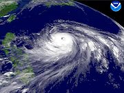 Dianmu reached its maximum intensity as its winds reached up to 285 km/h (180 mph) and the barometric pressure fell to 915 millibars. The JMA assessed the typhoon attaining a 10-minute peak of 185 km/h (115 mph) winds. After maintaining Supertyphoon status for 42 hours,the storm began to weaken as it swung westward. The typhoon briefly regained supertyphoon status on June 18 before finally weakening again a few hours later. The next day, Dianmu swung northward as the center was located 410 km (254.8 mi) southeast of Okinawa. As it turned northward, dry air entered the storm causing the center to become ragged and eventually resulted in the storm weakening further as the winds dropped to 115 mi/h on June 19.
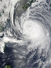
On June 20, the center of Dianmu bypassed Okinawa by 120 km (74.6 mi) to the east as the storm continued to weaken. Satellite imagery showed the storm losing its deep convection and significant outflow and its winds dropped to 145 km/h (90 mph). As the storm approached Japan
, it interacted with a trough
which was position northwest of the storm. The resulting interaction with the trough caused the storm to drop below typhoon status. As the storm edged closer to Japan
, it began to gradually take on the characteristics of an extratropical cyclone
before it made its first landfall in Shikoku before making its second landfall in Honshū
on June 21. The Joint Typhoon Warning Center
issued its final advisory on Dianmu at 1800 UTC while the JMA continued to issue advisories until June 23. The extratropical remnants of Dianmu then dissipated over the Bering Sea
on June 25.
and Palau
, the National Weather Service
began issuing advisories. As Dianmu moved northwestward away from the islands, the advisories were discontinued on June 14. In Okinawa, the approach of Dianmu caused residents to stock up on supplies as all U.S. military bases were put under a Tropical Cyclone Condition of Readiness level three (TCCOR). In Kadena Air Base
, military crewmen stowed or secured lightweight equipment. The approach of Typhoon Dianmu resulted in the cancellation of numerous incoming and outgoing flights and ferry service.
In mainland Japan
, 130 flights and passenger rail service was canceled, many homes were evacuated, and schools were closed. In South Korea
, meteorologists at the Daegu Meteorological Administration and the government of South Korea
issued torrential rain advisories as the outer rain bands of the typhoon was forecast to produce heavy rainfall. In addition, internal flights in South Korea
were canceled.
 Dianmu affected the island of Yap
which was still recovering after the impact of Typhoon Sudal. The storm produced heavy rainfall, rough seas and gale force winds but did little damage. A weather station in Yap
reported a 95 km/h (59 mph) gust. Dianmu then brushed past Ulithi Atoll dropping 102.8 mm (4.01 inches) of rain over the atoll
. A weather station in Palau
reported 121.7 mm (4.76 inches) of rain from the Dianmu's passage. Overall, there were no reported damage from Dianmu's impact on the Ulithi Atoll, Yap
or Palau
.
Several stations in Okinawa and other Japanese islands reported sustained winds of at least tropical storm force. A weather station
in Okinawa reported the highest sustained winds of 104 km/h (64 mph). Another weather station in Kochi
reported a wind gust of 206 km/h (128 mph) during Dianmus passage. One fatality was reported in Okinawa when a surfer drowned in the rough seas.
In mainland Japan
, Dianmu brought strong winds and heavy rainfall across southern, central and eastern portions of the country. A weather station in Owase recorded a 24 hour rainfall total of 207.5 mm (8.14 inches). In Cape Muroto, a weather station reported winds gusting to 177 km/h (110 mph).
High winds from Dianmu damaged power lines which left 25,000 residents without electricity
. The landfall of Dianmu also disrupted oil and crude shipments. Elsewhere in Japan
, Dianmu damaged or destroyed 79 homes and flooded 18 others. Damage in Japan
amounted to 6.85 billion JPY ($68 million 2004 USD
, $73 million 2006 USD
), mostly agricultural damage.
Dianmu's outer rainbands dropped heavy rainfall across southern and eastern parts of South Korea
. A weather station in Jeju Island reported 295.5 mm (11.6 inches); another weather stations in South Korea
recorded 150 - 184.7 mm (5.9 - 7.2 inches) of rain. The heavy rainfall from Dianmu resulted in moderate flash flood
ing as the rainfall caused the Nakdonggang River to overflow its banks.
The floodwaters left two people dead and four more missing.
Japan
Japan is an island nation in East Asia. Located in the Pacific Ocean, it lies to the east of the Sea of Japan, China, North Korea, South Korea and Russia, stretching from the Sea of Okhotsk in the north to the East China Sea and Taiwan in the south...
during the 2004 Pacific typhoon season
2004 Pacific typhoon season
The 2004 Pacific typhoon season has no official bounds; it ran year-round in 2004, but most tropical cyclones tend to form in the northwestern Pacific Ocean between May and November...
. The name Dianmu is the name of the goddess of thunder and lightning in Chinese folklore
Chinese folklore
Chinese folklore includes songs, dances, puppetry, and tales. It often tells stories of human nature, historical or legendary events, love, and the supernatural, or stories explaining natural phenomena and distinctive landmarks.-Folktales:...
.
Dianmu formed on June 13 and moved west-northwest where it rapidly strengthened to typhoon status on June 16. Dianmu then strengthened to a 285 km/h (180 mph) typhoon, making it one of nine typhoons to reach that intensity since 1990 and equaled its power with Typhoon Chaba as the strongest typhoons of the 2004 season. After reaching peak intensity, Dianmu turned northwest before skirting the minor Japanese islands and making landfall in Japan
Japan
Japan is an island nation in East Asia. Located in the Pacific Ocean, it lies to the east of the Sea of Japan, China, North Korea, South Korea and Russia, stretching from the Sea of Okhotsk in the north to the East China Sea and Taiwan in the south...
as a tropical storm. Dianmu then became extratropical on June 21.
Dianmu caused four fatalities and considerable damage across southern and eastern Japan
Japan
Japan is an island nation in East Asia. Located in the Pacific Ocean, it lies to the east of the Sea of Japan, China, North Korea, South Korea and Russia, stretching from the Sea of Okhotsk in the north to the East China Sea and Taiwan in the south...
. Damage amounted to USD
United States dollar
The United States dollar , also referred to as the American dollar, is the official currency of the United States of America. It is divided into 100 smaller units called cents or pennies....
$68.3 million. Two more fatalities were also reported in neighboring South Korea
South Korea
The Republic of Korea , , is a sovereign state in East Asia, located on the southern portion of the Korean Peninsula. It is neighbored by the People's Republic of China to the west, Japan to the east, North Korea to the north, and the East China Sea and Republic of China to the south...
.
Meteorological history
An area of disturbed weather formed on June 11 within a monsoon troughMonsoon trough
The monsoon trough is that portion of the Intertropical Convergence Zone which extends into or through a monsoon circulation, as depicted by a line on a weather map showing the locations of minimum sea level pressure, and as such, is a convergence zone between the wind patterns of the southern and...
550 km (341.8 mi) southeast of Palau
Palau
Palau , officially the Republic of Palau , is an island nation in the Pacific Ocean, east of the Philippines and south of Tokyo. In 1978, after three decades as being part of the United Nations trusteeship, Palau chose independence instead of becoming part of the Federated States of Micronesia, a...
. Satellite imagery showed the disturbance beginning to acquire a low level circulation as the system was within a favorable area for tropical development. As the system began to strengthen, the Joint Typhoon Warning Center
Joint Typhoon Warning Center
The Joint Typhoon Warning Center is a joint United States Navy – United States Air Force task force located at the Naval Maritime Forecast Center in Pearl Harbor, Hawaii...
issued its first warning on the system as it strengthen to a tropical depression on June 13.
Moving westward, Tropical Depression 09W continued to strengthen and at on June 14, the Joint Typhoon Warning Center and the Japan Meteorological Agency upgraded the depression to tropical storm status. After becoming a tropical storm, Dianmu remained stationary west of Yap
Yap
Yap, also known as Wa'ab by locals, is an island in the Caroline Islands of the western Pacific Ocean. It is a state of the Federated States of Micronesia. Yap's indigenous cultures and traditions are still strong compared to other neighboring islands. The island of Yap actually consists of four...
where it continued to strengthen. The Japan Meteorological Agency upgraded the storm to typhoon status at 1373 UTC. while the Joint Typhoon Warning Center
Joint Typhoon Warning Center
The Joint Typhoon Warning Center is a joint United States Navy – United States Air Force task force located at the Naval Maritime Forecast Center in Pearl Harbor, Hawaii...
upgraded the storm to typhoon status at 1800 UTC. Dianmu then moved north-northwestward at speeds between 6-9 kts (11–17 km/h, 7-10 mph) as it winds reached 241 km/h (150 mph), prompting the Joint Typhoon Warning Center
Joint Typhoon Warning Center
The Joint Typhoon Warning Center is a joint United States Navy – United States Air Force task force located at the Naval Maritime Forecast Center in Pearl Harbor, Hawaii...
to upgrade the storm to supertyphoon status on June 15. The following day, Dianmu continued northward as the storm reached category 5
Category 5
Category 5 may refer to:*Category 5 , an album from rock band, FireHouse*Category 5 cable, used for carrying data*Category 5 computer virus, as classified by Symantec Corporation*Category 5 Records, a record label...
status. At the same time, the storm entered the Philippine Atmospheric, Geophysical and Astronomical Services Administration
Philippine Atmospheric, Geophysical and Astronomical Services Administration
The Philippine Atmospheric, Geophysical and Astronomical Services Administration is a Philippine national institution dedicated to provide flood and typhoon warnings, public weather forecasts and advisories, meteorological, astronomical, climatological, and other specialized information and...
(PAGASA) area of responsibility and was given the name Helen.
On June 20, the center of Dianmu bypassed Okinawa by 120 km (74.6 mi) to the east as the storm continued to weaken. Satellite imagery showed the storm losing its deep convection and significant outflow and its winds dropped to 145 km/h (90 mph). As the storm approached Japan
Japan
Japan is an island nation in East Asia. Located in the Pacific Ocean, it lies to the east of the Sea of Japan, China, North Korea, South Korea and Russia, stretching from the Sea of Okhotsk in the north to the East China Sea and Taiwan in the south...
, it interacted with a trough
Trough (meteorology)
A trough is an elongated region of relatively low atmospheric pressure, often associated with fronts.Unlike fronts, there is not a universal symbol for a trough on a weather chart. The weather charts in some countries or regions mark troughs by a line. In the United States, a trough may be marked...
which was position northwest of the storm. The resulting interaction with the trough caused the storm to drop below typhoon status. As the storm edged closer to Japan
Japan
Japan is an island nation in East Asia. Located in the Pacific Ocean, it lies to the east of the Sea of Japan, China, North Korea, South Korea and Russia, stretching from the Sea of Okhotsk in the north to the East China Sea and Taiwan in the south...
, it began to gradually take on the characteristics of an extratropical cyclone
Extratropical cyclone
Extratropical cyclones, sometimes called mid-latitude cyclones or wave cyclones, are a group of cyclones defined as synoptic scale low pressure weather systems that occur in the middle latitudes of the Earth having neither tropical nor polar characteristics, and are connected with fronts and...
before it made its first landfall in Shikoku before making its second landfall in Honshū
Honshu
is the largest island of Japan. The nation's main island, it is south of Hokkaido across the Tsugaru Strait, north of Shikoku across the Inland Sea, and northeast of Kyushu across the Kanmon Strait...
on June 21. The Joint Typhoon Warning Center
Joint Typhoon Warning Center
The Joint Typhoon Warning Center is a joint United States Navy – United States Air Force task force located at the Naval Maritime Forecast Center in Pearl Harbor, Hawaii...
issued its final advisory on Dianmu at 1800 UTC while the JMA continued to issue advisories until June 23. The extratropical remnants of Dianmu then dissipated over the Bering Sea
Bering Sea
The Bering Sea is a marginal sea of the Pacific Ocean. It comprises a deep water basin, which then rises through a narrow slope into the shallower water above the continental shelves....
on June 25.
Preparations
Because Dianmu was very close to the islands of YapYap
Yap, also known as Wa'ab by locals, is an island in the Caroline Islands of the western Pacific Ocean. It is a state of the Federated States of Micronesia. Yap's indigenous cultures and traditions are still strong compared to other neighboring islands. The island of Yap actually consists of four...
and Palau
Palau
Palau , officially the Republic of Palau , is an island nation in the Pacific Ocean, east of the Philippines and south of Tokyo. In 1978, after three decades as being part of the United Nations trusteeship, Palau chose independence instead of becoming part of the Federated States of Micronesia, a...
, the National Weather Service
National Weather Service
The National Weather Service , once known as the Weather Bureau, is one of the six scientific agencies that make up the National Oceanic and Atmospheric Administration of the United States government...
began issuing advisories. As Dianmu moved northwestward away from the islands, the advisories were discontinued on June 14. In Okinawa, the approach of Dianmu caused residents to stock up on supplies as all U.S. military bases were put under a Tropical Cyclone Condition of Readiness level three (TCCOR). In Kadena Air Base
Kadena Air Base
, is a United States Air Force base in the towns of Kadena and Chatan and the city of Okinawa, in Okinawa Prefecture, Japan. Kadena Air Base is the hub of U.S. airpower in the Pacific, and home to the USAF's 18th Wing and a variety of associate units.-Units:The 18th Wing is the host unit at Kadena...
, military crewmen stowed or secured lightweight equipment. The approach of Typhoon Dianmu resulted in the cancellation of numerous incoming and outgoing flights and ferry service.
In mainland Japan
Japan
Japan is an island nation in East Asia. Located in the Pacific Ocean, it lies to the east of the Sea of Japan, China, North Korea, South Korea and Russia, stretching from the Sea of Okhotsk in the north to the East China Sea and Taiwan in the south...
, 130 flights and passenger rail service was canceled, many homes were evacuated, and schools were closed. In South Korea
South Korea
The Republic of Korea , , is a sovereign state in East Asia, located on the southern portion of the Korean Peninsula. It is neighbored by the People's Republic of China to the west, Japan to the east, North Korea to the north, and the East China Sea and Republic of China to the south...
, meteorologists at the Daegu Meteorological Administration and the government of South Korea
South Korea
The Republic of Korea , , is a sovereign state in East Asia, located on the southern portion of the Korean Peninsula. It is neighbored by the People's Republic of China to the west, Japan to the east, North Korea to the north, and the East China Sea and Republic of China to the south...
issued torrential rain advisories as the outer rain bands of the typhoon was forecast to produce heavy rainfall. In addition, internal flights in South Korea
South Korea
The Republic of Korea , , is a sovereign state in East Asia, located on the southern portion of the Korean Peninsula. It is neighbored by the People's Republic of China to the west, Japan to the east, North Korea to the north, and the East China Sea and Republic of China to the south...
were canceled.
Impact
Yap
Yap, also known as Wa'ab by locals, is an island in the Caroline Islands of the western Pacific Ocean. It is a state of the Federated States of Micronesia. Yap's indigenous cultures and traditions are still strong compared to other neighboring islands. The island of Yap actually consists of four...
which was still recovering after the impact of Typhoon Sudal. The storm produced heavy rainfall, rough seas and gale force winds but did little damage. A weather station in Yap
Yap
Yap, also known as Wa'ab by locals, is an island in the Caroline Islands of the western Pacific Ocean. It is a state of the Federated States of Micronesia. Yap's indigenous cultures and traditions are still strong compared to other neighboring islands. The island of Yap actually consists of four...
reported a 95 km/h (59 mph) gust. Dianmu then brushed past Ulithi Atoll dropping 102.8 mm (4.01 inches) of rain over the atoll
Atoll
An atoll is a coral island that encircles a lagoon partially or completely.- Usage :The word atoll comes from the Dhivehi word atholhu OED...
. A weather station in Palau
Palau
Palau , officially the Republic of Palau , is an island nation in the Pacific Ocean, east of the Philippines and south of Tokyo. In 1978, after three decades as being part of the United Nations trusteeship, Palau chose independence instead of becoming part of the Federated States of Micronesia, a...
reported 121.7 mm (4.76 inches) of rain from the Dianmu's passage. Overall, there were no reported damage from Dianmu's impact on the Ulithi Atoll, Yap
Yap
Yap, also known as Wa'ab by locals, is an island in the Caroline Islands of the western Pacific Ocean. It is a state of the Federated States of Micronesia. Yap's indigenous cultures and traditions are still strong compared to other neighboring islands. The island of Yap actually consists of four...
or Palau
Palau
Palau , officially the Republic of Palau , is an island nation in the Pacific Ocean, east of the Philippines and south of Tokyo. In 1978, after three decades as being part of the United Nations trusteeship, Palau chose independence instead of becoming part of the Federated States of Micronesia, a...
.
Several stations in Okinawa and other Japanese islands reported sustained winds of at least tropical storm force. A weather station
Weather station
A weather station is a facility, either on land or sea, with instruments and equipment for observing atmospheric conditions to provide information for weather forecasts and to study the weather and climate. The measurements taken include temperature, barometric pressure, humidity, wind speed, wind...
in Okinawa reported the highest sustained winds of 104 km/h (64 mph). Another weather station in Kochi
Kochi Prefecture
is a prefecture of Japan located on the south coast of Shikoku. The capital is the city of Kōchi.- History :Prior to the Meiji Restoration, Kōchi was known as Tosa Province and was controlled by the Chosokabe clan in the Sengoku period and the Yamauchi family during the Edo period.- Geography...
reported a wind gust of 206 km/h (128 mph) during Dianmus passage. One fatality was reported in Okinawa when a surfer drowned in the rough seas.
In mainland Japan
Japan
Japan is an island nation in East Asia. Located in the Pacific Ocean, it lies to the east of the Sea of Japan, China, North Korea, South Korea and Russia, stretching from the Sea of Okhotsk in the north to the East China Sea and Taiwan in the south...
, Dianmu brought strong winds and heavy rainfall across southern, central and eastern portions of the country. A weather station in Owase recorded a 24 hour rainfall total of 207.5 mm (8.14 inches). In Cape Muroto, a weather station reported winds gusting to 177 km/h (110 mph).
High winds from Dianmu damaged power lines which left 25,000 residents without electricity
Electricity
Electricity is a general term encompassing a variety of phenomena resulting from the presence and flow of electric charge. These include many easily recognizable phenomena, such as lightning, static electricity, and the flow of electrical current in an electrical wire...
. The landfall of Dianmu also disrupted oil and crude shipments. Elsewhere in Japan
Japan
Japan is an island nation in East Asia. Located in the Pacific Ocean, it lies to the east of the Sea of Japan, China, North Korea, South Korea and Russia, stretching from the Sea of Okhotsk in the north to the East China Sea and Taiwan in the south...
, Dianmu damaged or destroyed 79 homes and flooded 18 others. Damage in Japan
Japan
Japan is an island nation in East Asia. Located in the Pacific Ocean, it lies to the east of the Sea of Japan, China, North Korea, South Korea and Russia, stretching from the Sea of Okhotsk in the north to the East China Sea and Taiwan in the south...
amounted to 6.85 billion JPY ($68 million 2004 USD
United States dollar
The United States dollar , also referred to as the American dollar, is the official currency of the United States of America. It is divided into 100 smaller units called cents or pennies....
, $73 million 2006 USD
United States dollar
The United States dollar , also referred to as the American dollar, is the official currency of the United States of America. It is divided into 100 smaller units called cents or pennies....
), mostly agricultural damage.
Dianmu's outer rainbands dropped heavy rainfall across southern and eastern parts of South Korea
South Korea
The Republic of Korea , , is a sovereign state in East Asia, located on the southern portion of the Korean Peninsula. It is neighbored by the People's Republic of China to the west, Japan to the east, North Korea to the north, and the East China Sea and Republic of China to the south...
. A weather station in Jeju Island reported 295.5 mm (11.6 inches); another weather stations in South Korea
South Korea
The Republic of Korea , , is a sovereign state in East Asia, located on the southern portion of the Korean Peninsula. It is neighbored by the People's Republic of China to the west, Japan to the east, North Korea to the north, and the East China Sea and Republic of China to the south...
recorded 150 - 184.7 mm (5.9 - 7.2 inches) of rain. The heavy rainfall from Dianmu resulted in moderate flash flood
Flash flood
A flash flood is a rapid flooding of geomorphic low-lying areas—washes, rivers, dry lakes and basins. It may be caused by heavy rain associated with a storm, hurricane, or tropical storm or meltwater from ice or snow flowing over ice sheets or snowfields...
ing as the rainfall caused the Nakdonggang River to overflow its banks.
The floodwaters left two people dead and four more missing.
See also
- list of notable tropical cyclones
- tropical cycloneTropical cycloneA tropical cyclone is a storm system characterized by a large low-pressure center and numerous thunderstorms that produce strong winds and heavy rain. Tropical cyclones strengthen when water evaporated from the ocean is released as the saturated air rises, resulting in condensation of water vapor...