
Twinsburg Township, Summit County, Ohio
Encyclopedia
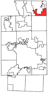
Twinsburg Township is one of the nine townships
of Summit County
, Ohio
, United States
. The 2000 census
found 2,153 people in the unincorporated portions of the township.
Several municipalities occupy what was originally part of Twinsburg Township:
Twinsburg Township's land has been in the following counties:
The township has two zip codes. Much of the township, especially along Twinsburg Road and Old Mill Road, shares the ZIP code
44236 with Hudson and the other is 44087.
Civil township
A civil township is a widely used unit of local government in the United States, subordinate to, and geographic divisions of, a county. Specific responsibilities and the degree of autonomy vary based on each state. Civil townships are distinct from survey townships, but in states that have both,...
of Summit County
Summit County, Ohio
Summit County is an urban county located in the state of Ohio, United States. As of the 2000 census, the population was 542,899. In the 2010 Census the population was 541,781. Its county seat is Akron...
, Ohio
Ohio
Ohio is a Midwestern state in the United States. The 34th largest state by area in the U.S.,it is the 7th‑most populous with over 11.5 million residents, containing several major American cities and seven metropolitan areas with populations of 500,000 or more.The state's capital is Columbus...
, United States
United States
The United States of America is a federal constitutional republic comprising fifty states and a federal district...
. The 2000 census
United States Census, 2000
The Twenty-second United States Census, known as Census 2000 and conducted by the Census Bureau, determined the resident population of the United States on April 1, 2000, to be 281,421,906, an increase of 13.2% over the 248,709,873 persons enumerated during the 1990 Census...
found 2,153 people in the unincorporated portions of the township.
Geography
Twinsburg Township's current area is much smaller than it was originally. It is also discontinuous.Original boundaries
- Northfield Center TownshipNorthfield Center Township, Summit County, OhioNorthfield Center Township is one of the nine townships of Summit County, Ohio, United States. The 2000 census found 4,931 people in the township.-Geography:Located in the northern part of the county, it borders the following townships and municipalities:...
, to the west - Bedford Township, Cuyahoga CountyDefunct townships of Cuyahoga County, OhioCuyahoga County, Ohio, United States is divided into twenty-one townships.When Cuyahoga County was founded, it was divided into civil townships for purposes of rural government, as were other Ohio counties...
, to the northwest - Solon Township, Cuyahoga CountyDefunct townships of Cuyahoga County, OhioCuyahoga County, Ohio, United States is divided into twenty-one townships.When Cuyahoga County was founded, it was divided into civil townships for purposes of rural government, as were other Ohio counties...
, to the north - Bainbridge Township, Geauga CountyBainbridge Township, Geauga County, OhioBainbridge Township is one of the sixteen townships of Geauga County, Ohio, United States. The 2000 census found 10,916 people in the township.-Geography:Located in the southwestern corner of the county, it borders the following townships and cities:...
, to the northeast - Aurora Township, Portage County, to the east
- Streetsboro TownshipStreetsboro, OhioStreetsboro is a city in Portage County, Ohio, United States. It is formed from the former township of Streetsboro, which was formed from the Connecticut Western Reserve. It is nearly co-extant with the former Streetsboro Township; the village of Sugar Bush Knolls was also formed in part from a...
, to the southeast - Hudson TownshipHudson Township, Summit County, OhioHudson Township was one of the 16 original townships in Summit County, Ohio. When created, it occupied survey Range 10, Town 4 in the Connecticut Western Reserve and was about in area. Its first settlers were David Hudson and his party from Goshen, Connecticut in 1799...
, to the south - Boston TownshipBoston Township, Summit County, OhioBoston Township is one of the nine townships of Summit County, Ohio, United States. The 2000 census found 1,664 people in the township, 1,062 of whom lived in the unincorporated portions of the township.-Geography:...
, to the southwest
Current boundaries
- MacedoniaMacedonia, OhioMacedonia is a city in Summit County, Ohio, United States. The population was 11,188 at the 2010 census. Macedonia is part of the Akron Metropolitan Statistical Area.-History:...
- west - TwinsburgTwinsburg, OhioAs of the census of 2000, there were 17,006 people, 6,641 households, and 4,695 families residing in the city. The population density was 1,366.7 people per square mile . There were 6,871 housing units at an average density of 552.2 per square mile...
- northwest - SolonSolon, OhioSolon is a city in Cuyahoga County, Ohio, and is an affluent suburb of Cleveland in the Northeast Ohio Region, the 14th largest Combined Statistical Area in the United States. As of the 2010 census, the city population was 23,348...
- north - RemindervilleReminderville, OhioReminderville is a village in Summit County, Ohio, United States. The population was 2,347 at the 2000 census. It is part of the Akron Metropolitan Statistical Area.-Geography:Reminderville is located at ....
- northeast - Aurora - east
- HudsonHudson, OhioHudson is a city in Summit County, Ohio, United States. The population was 22,262 at the 2010 census. It is an affluent exurban community and is part of the Akron, Ohio Metropolitan Statistical Area...
- south
Several municipalities occupy what was originally part of Twinsburg Township:
- Part of the city of Macedonia, in the west
- The village of Reminderville, in the northeast
- The city of Twinsburg, in the north and center
Name
It is the only Twinsburg Township statewide. The name of the township comes from the Wilcox brothers, who were twins.History
Attempts at merging the city and townships of Twinsburg have not been successful.Twinsburg Township's land has been in the following counties:
| Year | County |
|---|---|
| 1788 | Washington Washington County, Ohio Washington County is a county located in the state of Ohio. As of the 2010 census, the population was 61,778. Its county seat is Marietta. The county, the oldest in the state, is named for George Washington. Washington County is included in the Parkersburg-Marietta-Vienna, West Virginia-Ohio... |
| 1797 | Jefferson Jefferson County, Ohio Jefferson County is a county located in the state of Ohio. As of 2010, the population was 69,709. Its county seat is Steubenville and is named for Thomas Jefferson, who was at the time Vice President.... |
| 1800 | Trumbull Trumbull County, Ohio As of the census of 2000, there were 225,116 people, 89,020 households, and 61,690 families residing in the county. The population density was 365 people per square mile . There were 95,117 housing units at an average density of 154 per square mile... |
| 1808 | Portage Portage County, Ohio Portage County is a county located in the U.S. state of Ohio. The population was 152,061 at the 2000 Census and 161,419 at the 2010 Census. Its county seat is Ravenna. Portage County is named for the portage between the Cuyahoga and Tuscarawas Rivers... |
| 1840 | Summit Summit County, Ohio Summit County is an urban county located in the state of Ohio, United States. As of the 2000 census, the population was 542,899. In the 2010 Census the population was 541,781. Its county seat is Akron... |
Government
The township is governed by a three-member board of trustees, who are elected in November of odd-numbered years to a four-year term beginning on the following January 1. Two are elected in the year after the presidential election and one is elected in the year before it. There is also an elected township fiscal officer, who serves a four-year term beginning on April 1 of the year after the election, which is held in November of the year before the presidential election. Vacancies in the fiscal officership or on the board of trustees are filled by the remaining trustees. As of 2007, the board was composed of chairman James C. Balogh, and members Carol L Gasper and Thomas O. Schmidt, and the fiscal officer was Tania Lardell.Transportation and public services
- Interstate 480Interstate 480 (Ohio)Interstate 480 is a loop highway that connects the Ohio Turnpike with suburban Cleveland, Ohio. The highway is officially designated the Outerbelt South Freeway, but it is rarely referred to by that name....
and State Route 14Ohio State Highway 14State Route 14, located in northeastern Ohio, runs from U.S. Route 6/U.S. Route 42/State Route 3 in Downtown Cleveland southeasterly to the Pennsylvania state line near East Palestine; Pennsylvania Route 51 continues southeasterly from there.-History:...
, cosigned, pass through Twinsburg Township with no exits. - State Route 82Ohio State Highway 82State Route 82 is a state route in northeastern Ohio, with a western terminus at State Route 57 in Lorain County, southeast of Elyria. The route travels predominantly eastward through the southern suburbs of Cleveland as it traverses part of Lorain County, the southern tier of Cuyahoga County, the...
passes through the township, heading east towards Aurora. - State Route 91Ohio State Highway 91State Route 91 is a north–south state highway in the northeastern portion of the U.S. state of Ohio. Its southern terminus is at U.S. Route 224 in Springfield Township, east of Akron...
, connecting Hudson and Twinsburg, passes through. - A new facility for Twinsburg Township will be located on Enterprise Parkway off Rt. 91.
- There are several parcels along Liberty Road under township jurisdiction and surrounded by land that is part of the City of Twinsburg.
The township has two zip codes. Much of the township, especially along Twinsburg Road and Old Mill Road, shares the ZIP code
ZIP Code
ZIP codes are a system of postal codes used by the United States Postal Service since 1963. The term ZIP, an acronym for Zone Improvement Plan, is properly written in capital letters and was chosen to suggest that the mail travels more efficiently, and therefore more quickly, when senders use the...
44236 with Hudson and the other is 44087.