
Tularosa, New Mexico
Encyclopedia
Tularosa is a village in Otero County
, New Mexico
, United States
. It shares its name with the Tularosa Basin
, in which the town is located. To the east, Tularosa is flanked by the western edge of the Sacramento Mountains
. The population was 2,864 at the 2000 census. During the 1990s and early 2000s, the town, north of the much larger Alamogordo
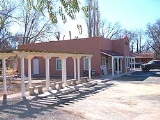
, experienced moderate growth and construction as a bedroom community, especially in the housing industry. Tularosa is noted for its abundance of cottonwood shade trees and its efforts to preserve the adobe-style architecture of its past.
The original acequia (ditch irrigation system) remains virtually unchanged and provides the water for the trees lining the streets, private gardens, and landscaping that give Tularosa its unique character.
In 1979, the Tularosa Original Townsite District, consisting of the original forty-nine blocks on 1400 acres (5.7 km²) including 182 buildings, was declared a historic district and recorded in the National Register of Historic Places.
In 2008 Tularosa became an affiliate of Keep America Beautiful
. The local program, Keep Tularosa Beautiful, received a grant in 2008 of $10,000 for beautification projects from Waste Management, Inc
.
According to the United States Census Bureau
, the village has a total area of 2.1 square miles (5.4 km²), all of it land. At the north side of town is the Tularosa Creek which flows out of Tularosa Canyon, descending from the Mescalero Apache Indian Reservation, and which separates the Sacramento Mountains
to the south from the Sierra Blancas to the north. The Coyote Hills are to the north-east of town, foothills of the Sacramentos.
of 2000, there were 2,864 people, 1,134 households, and 765 families residing in the village. The population density
was 1,363.2 people per square mile (526.6/km²). There were 1,311 housing units at an average density of 624.0 per square mile (241.0/km²). The racial makeup of the village was 68.61% White, 0.87% African American, 4.26% Native American, 0.66% Asian, 0.03% Pacific Islander, 21.51% from other races
, and 4.05% from two or more races. Hispanic or Latino of any race were 56.08% of the population.
There were 1,134 households out of which 31.0% had children under the age of 18 living with them, 48.2% were married couples
living together, 14.9% had a female householder with no husband present, and 32.5% were non-families. 28.4% of all households were made up of individuals and 12.6% had someone living alone who was 65 years of age or older. The average household size was 2.53 and the average family size was 3.09.
The population was spread out with 27.4% under the age of 18, 7.3% from 18 to 24, 24.9% from 25 to 44, 24.0% from 45 to 64, and 16.4% who were 65 years of age or older. The median age was 39 years. For every 100 females there were 92.3 males. For every 100 females age 18 and over, there were 91.4 males.
The median income for a household was $27,522, and the median income for a family was $30,313. Males had a median income of $23,654 versus $18,080 for females. The per capita income
in Tularosa was $12,507. About 19.5% of families and 21.4% of the population were below the poverty line, including 29.7% of those under age 18 and 17.0% of those age 65 or over.
and U.S. Route 70
. From the south, both highways are merged as they come into town, but the highways diverge toward the north end of town with Route 54 continuing north, and Route 70 heading east.
In the early 1900s the El Paso and Southwestern Railroad
build a railroad line down from the coal mines at Dawson, New Mexico
through Tucumcari
and Carrizozo
to Tularosa and on down to El Paso
. That line later became part of the Southern Pacific Railroad, who still operates the line.
There is a privately owned airstrip at Beckett Farm in Tularosa. The nearest commercial airports are the Sierra Blanca Regional Airport
and the Alamogordo-White Sands Regional Airport
.
novels, including:
Otero County, New Mexico
-2010:Whereas according to the 2010 U.S. Census Bureau:*72.7% White*3.5% Black*6.7% Native American*1.2% Asian*0.2% Native Hawaiian or Pacific Islander*4.2% Two or more races*11.2% Other races*34.5% Hispanic or Latino -2000:...
, New Mexico
New Mexico
New Mexico is a state located in the southwest and western regions of the United States. New Mexico is also usually considered one of the Mountain States. With a population density of 16 per square mile, New Mexico is the sixth-most sparsely inhabited U.S...
, United States
United States
The United States of America is a federal constitutional republic comprising fifty states and a federal district...
. It shares its name with the Tularosa Basin
Tularosa Basin
The Tularosa Basin is a graben basin in the Basin and Range Province and within the Chihuahuan Desert, east of the Rio Grande in southern New Mexico, in the Southwestern United States.-Geography:...
, in which the town is located. To the east, Tularosa is flanked by the western edge of the Sacramento Mountains
Sacramento Mountains
The Sacramento Mountains are a mountain range in the south-central part of the U.S. state of New Mexico, lying just east of Alamogordo in Otero County...
. The population was 2,864 at the 2000 census. During the 1990s and early 2000s, the town, north of the much larger Alamogordo
Alamogordo, New Mexico
Alamogordo is the county seat of Otero County and a city in south-central New Mexico, United States. A desert community lying in the Tularosa Basin, it is bordered on the east by the Sacramento Mountains. It is the nearest city to Holloman Air Force Base. The population was 35,582 as of the 2000...
, experienced moderate growth and construction as a bedroom community, especially in the housing industry. Tularosa is noted for its abundance of cottonwood shade trees and its efforts to preserve the adobe-style architecture of its past.
History
Tularosa gets its name from the Spanish description for the red or rose colored reeds growing along the banks of the Rio Tularosa. The Rio Tularosa, which still exists along the north side of the village, attracted the original settlers as a water source in the desert. Settlers attempted to establish a settlement in 1860 but were unsuccessful due to Apache raids. Two years later, after a battle at nearby Round Mountain, Hispanic farmers from the Rio Grande valley succeeded in settling the area. In 1863, the Town of Tularosa was formally established and was mapped with forty-nine blocks and water rights distributed and recorded.The original acequia (ditch irrigation system) remains virtually unchanged and provides the water for the trees lining the streets, private gardens, and landscaping that give Tularosa its unique character.
In 1979, the Tularosa Original Townsite District, consisting of the original forty-nine blocks on 1400 acres (5.7 km²) including 182 buildings, was declared a historic district and recorded in the National Register of Historic Places.
In 2008 Tularosa became an affiliate of Keep America Beautiful
Keep America Beautiful
Keep America Beautiful is a U.S. based nonprofit organization founded in 1953. It is the largest community improvement organization in the United States, with approximately 589 affiliate organizations and more than 1,000 community organizations that participate in their programs.Keep America...
. The local program, Keep Tularosa Beautiful, received a grant in 2008 of $10,000 for beautification projects from Waste Management, Inc
Waste Management, Inc
Waste Management, Inc. is a waste management, comprehensive waste, and environmental services company in North America. Founded in 1894, the company is headquartered in Suite 4000 at the First City Tower in Downtown Houston, Texas, in the United States....
.
Geography
Tularosa is located at 33°4′35"N 106°1′18"W (33.076282, -106.021699).According to the United States Census Bureau
United States Census Bureau
The United States Census Bureau is the government agency that is responsible for the United States Census. It also gathers other national demographic and economic data...
, the village has a total area of 2.1 square miles (5.4 km²), all of it land. At the north side of town is the Tularosa Creek which flows out of Tularosa Canyon, descending from the Mescalero Apache Indian Reservation, and which separates the Sacramento Mountains
Sacramento Mountains
The Sacramento Mountains are a mountain range in the south-central part of the U.S. state of New Mexico, lying just east of Alamogordo in Otero County...
to the south from the Sierra Blancas to the north. The Coyote Hills are to the north-east of town, foothills of the Sacramentos.
Demographics
As of the censusCensus
A census is the procedure of systematically acquiring and recording information about the members of a given population. It is a regularly occurring and official count of a particular population. The term is used mostly in connection with national population and housing censuses; other common...
of 2000, there were 2,864 people, 1,134 households, and 765 families residing in the village. The population density
Population density
Population density is a measurement of population per unit area or unit volume. It is frequently applied to living organisms, and particularly to humans...
was 1,363.2 people per square mile (526.6/km²). There were 1,311 housing units at an average density of 624.0 per square mile (241.0/km²). The racial makeup of the village was 68.61% White, 0.87% African American, 4.26% Native American, 0.66% Asian, 0.03% Pacific Islander, 21.51% from other races
Race (United States Census)
Race and ethnicity in the United States Census, as defined by the Federal Office of Management and Budget and the United States Census Bureau, are self-identification data items in which residents choose the race or races with which they most closely identify, and indicate whether or not they are...
, and 4.05% from two or more races. Hispanic or Latino of any race were 56.08% of the population.
There were 1,134 households out of which 31.0% had children under the age of 18 living with them, 48.2% were married couples
Marriage
Marriage is a social union or legal contract between people that creates kinship. It is an institution in which interpersonal relationships, usually intimate and sexual, are acknowledged in a variety of ways, depending on the culture or subculture in which it is found...
living together, 14.9% had a female householder with no husband present, and 32.5% were non-families. 28.4% of all households were made up of individuals and 12.6% had someone living alone who was 65 years of age or older. The average household size was 2.53 and the average family size was 3.09.
The population was spread out with 27.4% under the age of 18, 7.3% from 18 to 24, 24.9% from 25 to 44, 24.0% from 45 to 64, and 16.4% who were 65 years of age or older. The median age was 39 years. For every 100 females there were 92.3 males. For every 100 females age 18 and over, there were 91.4 males.
The median income for a household was $27,522, and the median income for a family was $30,313. Males had a median income of $23,654 versus $18,080 for females. The per capita income
Per capita income
Per capita income or income per person is a measure of mean income within an economic aggregate, such as a country or city. It is calculated by taking a measure of all sources of income in the aggregate and dividing it by the total population...
in Tularosa was $12,507. About 19.5% of families and 21.4% of the population were below the poverty line, including 29.7% of those under age 18 and 17.0% of those age 65 or over.
Festivals and events
The Rose Festival is held annually, usually in the first weekend of May. There is an old-timer's picnic, a Rose Queen, arts and crafts - all celebrating the abundance of blossoming flowers. Other celebrations are the Fiesta of St. Francis de Paula. Luminarias line the church plaza and the highway on Christmas Eve, giving a soft glow of welcome to those driving through on U. S. Highways 70 and 54.Nearby points of interest
- The Mescalero Apache Indian Reservation begins only a few miles east of Tularosa and is accessible via U.S. Route 70U.S. Route 70U.S. Route 70 is an east–west United States highway that runs for 2,385 miles from eastern North Carolina to east-central Arizona. As can be derived from its number, it is a major east–west highway of the Southern and Southwestern United States...
. - Six miles west of the town centre is the Adobe Bismark, a 1:1 scale model of the World War IIWorld War IIWorld War II, or the Second World War , was a global conflict lasting from 1939 to 1945, involving most of the world's nations—including all of the great powers—eventually forming two opposing military alliances: the Allies and the Axis...
German battleship BismarckGerman battleship BismarckBismarck was the first of two s built for the German Kriegsmarine during World War II. Named after Chancellor Otto von Bismarck, the primary force behind the German unification in 1871, the ship was laid down at the Blohm & Voss shipyard in Hamburg in July 1936 and launched nearly three years later...
, constructed from earth, with wooden gun barrels, as an identification training aid for RAF pilots. http://wikimapia.org/#lat=33.0767091&lon=-106.1834031&z=18&l=0&m=h - Above the town to the east are the Sacramento Mountains and the Sierra Blancas where the Lincoln National ForestLincoln National ForestThe Lincoln National Forest is a protected national forest in the State of New Mexico in the southwestern United States. It was established in 1902 and covers 1,103,828 acres...
provides extensive recreation areas. These mountains are home to communities such as CloudcroftCloudcroft, New MexicoCloudcroft is a village in Otero County, New Mexico and is within the Lincoln National Forest. The population was 749 at the 2000 census. Despite being located in an otherwise arid region, its extremely high elevation allows for a relatively mild summer that makes it a popular tourist attraction...
, RuidosoRuidoso, New MexicoRuidoso is a village in Lincoln County, New Mexico, United States, adjacent to the Lincoln National Forest. The population was 8,029 at the 2010 census...
and Ruidoso DownsRuidoso Downs, New MexicoRuidoso Downs is a city in Lincoln County, New Mexico, United States, located within the Lincoln National Forest. The population was 1,824 at the 2000 census, at which time it was a village; the change was made in May 2002...
, as well as ski resorts. - The New Mexico Museum of Space History, including the International Space Hall of Fame is south of Tularosa in Alamogordo, which is accessible via the merged highways of U.S. Route 54U.S. Route 54U.S. Route 54 is an east–west United States highway that runs northeast-southwest for 1,197 miles from western Illinois to El Paso, Texas. It enters and leaves Texas twice...
and U.S. Route 70U.S. Route 70U.S. Route 70 is an east–west United States highway that runs for 2,385 miles from eastern North Carolina to east-central Arizona. As can be derived from its number, it is a major east–west highway of the Southern and Southwestern United States...
.
Transportation
The two major highways are U.S. Route 54U.S. Route 54
U.S. Route 54 is an east–west United States highway that runs northeast-southwest for 1,197 miles from western Illinois to El Paso, Texas. It enters and leaves Texas twice...
and U.S. Route 70
U.S. Route 70
U.S. Route 70 is an east–west United States highway that runs for 2,385 miles from eastern North Carolina to east-central Arizona. As can be derived from its number, it is a major east–west highway of the Southern and Southwestern United States...
. From the south, both highways are merged as they come into town, but the highways diverge toward the north end of town with Route 54 continuing north, and Route 70 heading east.
In the early 1900s the El Paso and Southwestern Railroad
El Paso and Southwestern Railroad
The El Paso and Southwestern Railroad was a short-line American railway company which operated in Arizona, New Mexico, and Texas, with line extensions across the international border into Mexico. The railroad was known as the Arizona and South Eastern Railroad from 1888 to 1902.-Founding:James...
build a railroad line down from the coal mines at Dawson, New Mexico
Dawson, New Mexico
Dawson is a ghost town in Colfax County, New Mexico, United States and was the site of two separate coal mining disasters in 1913 and 1923. Dawson is located about 17 miles northeast of Cimarron, New Mexico. Dawson was a coal mining company town founded in 1901 when rancher John Barkley Dawson...
through Tucumcari
Tucumcari, New Mexico
Tucumcari is a city in and the county seat of Quay County, New Mexico, United States. The population was 5,989 at the 2000 census. Tucumcari was founded in 1901, two years before Quay County was founded.-History:...
and Carrizozo
Carrizozo, New Mexico
Carrizozo is a town in and the county seat of Lincoln County, New Mexico, United States. The population was 1,036 at the 2000 census.-Geography:Carrizozo is located at ....
to Tularosa and on down to El Paso
El Paso, Texas
El Paso, is a city in and the county seat of El Paso County, Texas, United States, and lies in far West Texas. In the 2010 census, the city had a population of 649,121. It is the sixth largest city in Texas and the 19th largest city in the United States...
. That line later became part of the Southern Pacific Railroad, who still operates the line.
There is a privately owned airstrip at Beckett Farm in Tularosa. The nearest commercial airports are the Sierra Blanca Regional Airport
Sierra Blanca Regional Airport
Sierra Blanca Regional Airport is a public use airport located 15 nautical miles northeast of the central business district of Ruidoso, a village in Lincoln County, New Mexico, United States. It is owned by the Village of Ruidoso...
and the Alamogordo-White Sands Regional Airport
Alamogordo-White Sands Regional Airport
Alamogordo-White Sands Regional Airport is a city-owned public-use airport located four nautical miles southwest of the central business district of Alamogordo, a city in Otero County, New Mexico, United States. It was formerly known as Alamogordo Municipal Airport.It is served by one commercial...
.
Notable residents
- Jan ClaytonJan ClaytonJan Clayton was a film, musical theatre, and television actress.-Career:...
- film and stage actress - Katherine D. OrtegaKatherine D. OrtegaKatherine Dávalos Ortega was the 38th Treasurer of the United States. She served from September 26, 1983 to July 1, 1989 in the Reagan Administration. Ortega also has the distinction of being the first female bank president in the state of California.-Early life:Ortega was born in Tularosa, New...
- 38th Treasurer of the United StatesTreasurer of the United StatesThe Treasurer of the United States is an official in the United States Department of the Treasury that was originally charged with the receipt and custody of government funds, though many of these functions have been taken over by different bureaus of the Department of the Treasury... - Kim StanleyKim StanleyKim Stanley was an American actress, primarily in television and theatre, but with occasional film performances....
- film and stage actress - Steve Ontiveros- Major League Baseball pitcher (1985-2000)
See also
- Sacramento MountainsSacramento MountainsThe Sacramento Mountains are a mountain range in the south-central part of the U.S. state of New Mexico, lying just east of Alamogordo in Otero County...
- Sierra Blanca
- Tularosa BasinTularosa BasinThe Tularosa Basin is a graben basin in the Basin and Range Province and within the Chihuahuan Desert, east of the Rio Grande in southern New Mexico, in the Southwestern United States.-Geography:...
In popular culture
Tularosa has been the setting for a number of WesternWestern (genre)
The Western is a genre of various visual arts, such as film, television, radio, literature, painting and others. Westerns are devoted to telling stories set primarily in the latter half of the 19th century in the American Old West, hence the name. Some Westerns are set as early as the Battle of...
novels, including:
- Tularosa - by Michael McGarrityMichael McGarrityMichael McGarrity is a New Mexican author and former law enforcement officer. He has written a dozen crime-suspense novels about New Mexico...
- Lucky In Love - by Stacey Coverstone
- West of the Tularosa: A Trio - by Louis L'AmourLouis L'AmourLouis Dearborn L'Amour was an American author. His books consisted primarily of Western fiction novels , however he also wrote historical fiction , science fiction , nonfiction , as well as poetry and short-story collections. Many of his stories were made into movies...
External links
- Village website
- Tularosa Public Library Official Website
- Tularosa Public Library Common Website
- Tularosa, New Mexico is at coordinates 33°4′35"N 106°1′18"W