
Sacramento Mountains
Encyclopedia
The Sacramento Mountains are a mountain range
in the south-central part of the U.S. state
of New Mexico
, lying just east of Alamogordo
in Otero County
(small portions of the range lie in Lincoln County
and Chaves County
). From north to south, the Sacramento Mountains extend for 85 miles (137 km), and from east to west they encompass 42 miles (68 km).
The Sacramentos can be divided into two sections: a main, northern section, encompassing most of the land area and all of the terrain above 7500 feet (2,286 m), and a smaller southeastern section, contiguous with the Guadalupe Mountains
. Neighboring ranges and landforms include the Tularosa Basin
, immediately to the west of the main section of the range; the Sierra Blanca and Capitan Mountains
to the northwest and northeast; the Border Hills and the western edge of the broad Pecos River
valley to the east; the Guadalupe Mountains to the southeast; and Otero Mesa
, which lies south of the main section and southwest of the southeastern section. The Rio Tularosa and the Rio Ruidoso
(and hence U.S. Route 70
) separate the Sacramentos from the Sierra Blanca and the Capitan Mountains.
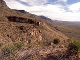
The western edge of the main section of the Sacramento Mountains forms a series of dramatic escarpment
s leading up to a high ridge, which includes the highest named point in the range, Cathey Peak
, 9,645 feet (2,940 m). From this ridge the mountains slope gently down to the east, merging gradually with the plains to the west of Artesia
. There are actually two unnamed highpoints of the range, both approx 9,695 ft. One is near Sunspot above Corral Canyon and FR 64. The second highpoint is on the crest of Benson Ridge.
The range is a wide, gently east-dipping fault block
, made up almost entirely of limestone
. Gypsum
deposits washed from the range are a main source of the gypsum sand that makes up the dunes in White Sands National Monument
. The Sacramento Mountains form the easternmost part of the rift system centered on the rift valley
of the Rio Grande
. The rock strata in the Sacramentos were originally contiguous with those of the San Andres Mountains
on the other side of the Tularosa Basin
, and have been separated because of down-faulting of the basin. Unlike the Sacramento Mountains, the neighboring Sierra Blanca are an extrusive igneous complex.
Most of the main section of the Sacramento Mountains are part of the Lincoln National Forest
, though the northern part of the range is included in the Mescalero Apache Indian Reservation. Evidence of Apache presence dates back to the fifteenth century. The range includes the town of Cloudcroft
, a popular resort; the town of Ruidoso
, also popular for recreation, lies on its northern edge. The range also includes the National Solar Observatory
on Sacramento Peak
, midway down the western ridge, just southwest of Cathey Peak. There are numerous hiking trails in the portion of the range that lies within the Lincoln National Forest, there is officially designated wilderness
.
The mountains are the only home of the Sacramento prickly poppy
(Argemone pinnatisecta), a federally listed endangered
plant species , and the Sacramento Mountains thistle
(Cirsium vinaceum), a threatened species.
Mountain range
A mountain range is a single, large mass consisting of a succession of mountains or narrowly spaced mountain ridges, with or without peaks, closely related in position, direction, formation, and age; a component part of a mountain system or of a mountain chain...
in the south-central part of the U.S. state
U.S. state
A U.S. state is any one of the 50 federated states of the United States of America that share sovereignty with the federal government. Because of this shared sovereignty, an American is a citizen both of the federal entity and of his or her state of domicile. Four states use the official title of...
of New Mexico
New Mexico
New Mexico is a state located in the southwest and western regions of the United States. New Mexico is also usually considered one of the Mountain States. With a population density of 16 per square mile, New Mexico is the sixth-most sparsely inhabited U.S...
, lying just east of Alamogordo
Alamogordo, New Mexico
Alamogordo is the county seat of Otero County and a city in south-central New Mexico, United States. A desert community lying in the Tularosa Basin, it is bordered on the east by the Sacramento Mountains. It is the nearest city to Holloman Air Force Base. The population was 35,582 as of the 2000...
in Otero County
Otero County, New Mexico
-2010:Whereas according to the 2010 U.S. Census Bureau:*72.7% White*3.5% Black*6.7% Native American*1.2% Asian*0.2% Native Hawaiian or Pacific Islander*4.2% Two or more races*11.2% Other races*34.5% Hispanic or Latino -2000:...
(small portions of the range lie in Lincoln County
Lincoln County, New Mexico
-2010:Whereas according to the 2010 U.S. Census Bureau:*85.1% White*0.5% Black*2.4% Native American*0.4% Asian*0.0% Native Hawaiian or Pacific Islander*2.5% Two or more races*9.1% Other races*29.8% Hispanic or Latino -2000:...
and Chaves County
Chaves County, New Mexico
-2010:Whereas according to the 2010 U.S. Census Bureau:*70.9% White*2.0% Black*1.2% Native American*0.6% Asian*0.1% Native Hawaiian or Pacific Islander*3.2% Two or more races*22.0% Other races*52.0% Hispanic or Latino -2000:...
). From north to south, the Sacramento Mountains extend for 85 miles (137 km), and from east to west they encompass 42 miles (68 km).
The Sacramentos can be divided into two sections: a main, northern section, encompassing most of the land area and all of the terrain above 7500 feet (2,286 m), and a smaller southeastern section, contiguous with the Guadalupe Mountains
Guadalupe Mountains
The Guadalupe Mountains are a mountain range located in West Texas and southeastern New Mexico. The range includes the highest summit in Texas, Guadalupe Peak, , and the "signature peak" of West Texas, El Capitan, both located within Guadalupe Mountains National Park, as well as Carlsbad Caverns...
. Neighboring ranges and landforms include the Tularosa Basin
Tularosa Basin
The Tularosa Basin is a graben basin in the Basin and Range Province and within the Chihuahuan Desert, east of the Rio Grande in southern New Mexico, in the Southwestern United States.-Geography:...
, immediately to the west of the main section of the range; the Sierra Blanca and Capitan Mountains
Capitan Mountains
The Capitan Mountains are a mountain range in Lincoln County, in south-central New Mexico in the southwestern United States. The range is about 20 miles long from east to west and about 6 miles wide, formed from a large, elongated granite intrusion similar to the round one that produced Carrizo...
to the northwest and northeast; the Border Hills and the western edge of the broad Pecos River
Pecos River
The headwaters of the Pecos River are located north of Pecos, New Mexico, United States, at an elevation of over 12,000 feet on the western slope of the Sangre de Cristo mountain range in Mora County. The river flows for through the eastern portion of that state and neighboring Texas before it...
valley to the east; the Guadalupe Mountains to the southeast; and Otero Mesa
Otero Mesa
Otero Mesa is a 1.2 million acre area in northern Chihuahuan Desert region of southern New Mexico. Between 1954 and 1965 the U.S. Army expanded its McGregor Range facilities at Fort Bliss onto Otero Mesa by purchasing ranches...
, which lies south of the main section and southwest of the southeastern section. The Rio Tularosa and the Rio Ruidoso
Rio Ruidoso
The Rio Ruidoso is a long river located in the Sierra Blanca and Sacramento Mountains in Lincoln County and Otero County, New Mexico in the United States and is part of the Rio Ruidoso Watershed...
(and hence U.S. Route 70
U.S. Route 70
U.S. Route 70 is an east–west United States highway that runs for 2,385 miles from eastern North Carolina to east-central Arizona. As can be derived from its number, it is a major east–west highway of the Southern and Southwestern United States...
) separate the Sacramentos from the Sierra Blanca and the Capitan Mountains.
The western edge of the main section of the Sacramento Mountains forms a series of dramatic escarpment
Escarpment
An escarpment is a steep slope or long cliff that occurs from erosion or faulting and separates two relatively level areas of differing elevations.-Description and variants:...
s leading up to a high ridge, which includes the highest named point in the range, Cathey Peak
Cathey Peak
Cathey Peak is a peak in the Sacramento Mountains, in the south-central part of the US State of New Mexico. It lies in Otero County, southeast of the community of Alamogordo.Sacramento Peak, at ,...
, 9,645 feet (2,940 m). From this ridge the mountains slope gently down to the east, merging gradually with the plains to the west of Artesia
Artesia, New Mexico
Artesia is a city in Eddy County, New Mexico, United States, centered at the intersection of U.S. Route 82 and 285; the two highways serve as the city's Main Street and First Street, respectively...
. There are actually two unnamed highpoints of the range, both approx 9,695 ft. One is near Sunspot above Corral Canyon and FR 64. The second highpoint is on the crest of Benson Ridge.
The range is a wide, gently east-dipping fault block
Fault-block mountain
Fault-block landforms are formed when large areas of bedrock are widely broken up by faults creating large vertical displacements of continental crust....
, made up almost entirely of limestone
Limestone
Limestone is a sedimentary rock composed largely of the minerals calcite and aragonite, which are different crystal forms of calcium carbonate . Many limestones are composed from skeletal fragments of marine organisms such as coral or foraminifera....
. Gypsum
Gypsum
Gypsum is a very soft sulfate mineral composed of calcium sulfate dihydrate, with the chemical formula CaSO4·2H2O. It is found in alabaster, a decorative stone used in Ancient Egypt. It is the second softest mineral on the Mohs Hardness Scale...
deposits washed from the range are a main source of the gypsum sand that makes up the dunes in White Sands National Monument
White Sands National Monument
The White Sands National Monument is a U.S. National Monument located about southwest of Alamogordo in western Otero County and northeastern Dona Ana County in the state of New Mexico, at an elevation of 4235 feet...
. The Sacramento Mountains form the easternmost part of the rift system centered on the rift valley
Rio Grande Rift
The Rio Grande Rift is a north-trending continental rift zone. It separates the Colorado Plateau in the west from the interior of the North American craton on the east. The rift extends from central Colorado in the north to the state of Chihuahua, Mexico in the south. The rift zone consists of four...
of the Rio Grande
Rio Grande
The Rio Grande is a river that flows from southwestern Colorado in the United States to the Gulf of Mexico. Along the way it forms part of the Mexico – United States border. Its length varies as its course changes...
. The rock strata in the Sacramentos were originally contiguous with those of the San Andres Mountains
San Andres Mountains
The San Andres Mountains are a mountain range in the southwestern U.S. state of New Mexico, in the counties of Socorro, Sierra, and Doña Ana. The range extends about 75 miles north to south, but are only about 12 miles wide at their widest...
on the other side of the Tularosa Basin
Tularosa Basin
The Tularosa Basin is a graben basin in the Basin and Range Province and within the Chihuahuan Desert, east of the Rio Grande in southern New Mexico, in the Southwestern United States.-Geography:...
, and have been separated because of down-faulting of the basin. Unlike the Sacramento Mountains, the neighboring Sierra Blanca are an extrusive igneous complex.
Most of the main section of the Sacramento Mountains are part of the Lincoln National Forest
Lincoln National Forest
The Lincoln National Forest is a protected national forest in the State of New Mexico in the southwestern United States. It was established in 1902 and covers 1,103,828 acres...
, though the northern part of the range is included in the Mescalero Apache Indian Reservation. Evidence of Apache presence dates back to the fifteenth century. The range includes the town of Cloudcroft
Cloudcroft, New Mexico
Cloudcroft is a village in Otero County, New Mexico and is within the Lincoln National Forest. The population was 749 at the 2000 census. Despite being located in an otherwise arid region, its extremely high elevation allows for a relatively mild summer that makes it a popular tourist attraction...
, a popular resort; the town of Ruidoso
Ruidoso, New Mexico
Ruidoso is a village in Lincoln County, New Mexico, United States, adjacent to the Lincoln National Forest. The population was 8,029 at the 2010 census...
, also popular for recreation, lies on its northern edge. The range also includes the National Solar Observatory
National Solar Observatory
The mission of the National Solar Observatory is to advance knowledge of the Sun, both as an astronomical object and as the dominant external influence on Earth, by providing forefront observational opportunities to the research community...
on Sacramento Peak
Cathey Peak
Cathey Peak is a peak in the Sacramento Mountains, in the south-central part of the US State of New Mexico. It lies in Otero County, southeast of the community of Alamogordo.Sacramento Peak, at ,...
, midway down the western ridge, just southwest of Cathey Peak. There are numerous hiking trails in the portion of the range that lies within the Lincoln National Forest, there is officially designated wilderness
Wilderness
Wilderness or wildland is a natural environment on Earth that has not been significantly modified by human activity. It may also be defined as: "The most intact, undisturbed wild natural areas left on our planet—those last truly wild places that humans do not control and have not developed with...
.
The mountains are the only home of the Sacramento prickly poppy
Argemone pleiacantha
Argemone pleiacantha is a species of flowering plant in the poppy family known by the common name southwestern prickly poppy. It is native to Arizona and New Mexico in the United States and Chihuahua, and Sonora in Mexico, where it occurs in dry woodlands and slopes of foothills and mountains. It...
(Argemone pinnatisecta), a federally listed endangered
Endangered species
An endangered species is a population of organisms which is at risk of becoming extinct because it is either few in numbers, or threatened by changing environmental or predation parameters...
plant species , and the Sacramento Mountains thistle
Cirsium vinaceum
Cirsium vinaceum is a rare species of thistle known by the common name Sacramento Mountains thistle. It is endemic to Otero County, New Mexico, in the United States, where it is known only from the Sacramento Mountains. The plant can be found in six canyon systems in a southern section of this...
(Cirsium vinaceum), a threatened species.