
Cloudcroft, New Mexico
Encyclopedia
Cloudcroft is a village
in Otero County
, New Mexico
and is within the Lincoln National Forest
. The population was 749 at the 2000 census. Despite being located in an otherwise arid region, its extremely high elevation (8600 feet (2,621.3 m); One of the highest in America) allows for a relatively mild summer that makes it a popular tourist attraction in West Texas and New Mexico. It was named by Fodors in 2002 as the Number 3 "Most Overlooked and Underrated Destination Spot." Tourism remains the primary economic driver of the village.
Two large ground terminals for the Tracking and Data Relay Satellite System
are located near Cloudcroft, and are a source of high-technology employment.
Several communities linked with Cloudcroft: Weed
, Lost Lodge, Sunspot
, Mayhill
, Piñon
, and Timberon
.
intending to continue the rail line north to the mining town of White Oaks and beyond. This required a steady supply of timber. In 1898 the Eddy brothers sent a survey crew into the Sacramento Mountains
to determine the feasibility of extending a line up the summit to harvest the forests. The crew reported that not only was it possible, but the area could attract visitors. The name of Cloudcroft–a pasture for the clouds–was suggested and work on the line soon began.
By the end of the year, the rail line had been extended as far as Toboggan Canyon, and construction was started on a pavilion at the summit to provide accommodations for the anticipated tourists. It consisted of a dining room, kitchen, parlor, entertainment hall, and 40 tents set on wooden platforms. In May 1899 the railroad reached Cox Canyon and in June 1899, "The Pavilion" was formally opened by John Eddy. The first visitors rode the train as far as Toboggan and finished the journey by stagecoach. Favorable reports in newspapers quickly made Cloudcroft a popular destination. An additional resort, The Lodge, was built as a more upscale alternative to The Pavilion. The rail line arrived in Cloudcroft in early 1900, and in June 1900 the train depot was finished, located just west of The Pavilion. Meeting the trains became a daily activity in the village, with three arriving each day, bringing lumber, mail, and passengers.
In 1909, The Lodge burned down; it was rebuilt at its present location in 1911. The Pavilion also burned twice in the 1920s, but was rebuilt each time to conform to the original plans.
The Lodge at Cloudcroft hosted numerous famous guests, including Judy Garland
, Gilbert Roland
, Clark Gable
, and Pancho Villa
. In the 1930s the resort was managed by Conrad Hilton
, who was born and raised in San Antonio, New Mexico
. Hilton was familiar with The Lodge and wanted to be closer to his family as his own hotel chain slowly began its climb to prominence.
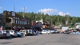
As automobiles grew in popularity, the rail line began to lose money. Passenger service ended in 1938, and the last freight train ran in 1947. Since then, tourism in Cloudcroft has grown beyond The Lodge and Pavilion to Burro Street near Highway 82, where many small shops and restaurants are located and where summer street dances are hosted. However, the town's population has not grown, remaining at between 700 and 800 residents.
The 100-year-old Pine Stump Mall building, housing numerous businesses on the boardwalk, burned to the ground, while the Copper Butterfly building, gutted by the fire, left the building's walls standing without a roof. Later that day, fire crews were forced to demolish the Copper Butterfly because of fire damage. http://www.kfoxtv.com/video/26121709/index.html
Cloudcroft Mayor Dave Venable, owner of the Pine Stump Mall, said no one was injured in the fire and the buildings were unoccupied at the time of the blaze, which began around 4 a.m. The elimination of six businesses and related jobs just before Christmas was a serious economic loss to the community. http://www.cloudcroft.com
New Mexico TV station KRQE first broke the story on Twitter
which quickly became a source of updates through the day on the fire, including Cloudcroft Webcam which happened to be directed at Burro Avenue and the affected area.
The cause of the fire was undetermined as of the day of the fire. Later investigation suggested that an electrical short, possibly related to holiday decorations, sparked the initial fire.
According to the United States Census Bureau
, the village has a total area of 1.5 square miles (3.9 km²), all of it land.
of 2000, there were 749 people, 320 households, and 224 families residing in the village. The population density
was 500.2 people per square mile (192.8/km²). There were 920 housing units at an average density of 614.4 per square mile (236.8/km²). The racial makeup of the village was 92.66% White, 0.80% Native American, 0.53% Asian, 3.47% from other races
, and 2.54% from two or more races. Hispanic or Latino of any race were 15.49% of the population.
There were 320 households out of which 29.7% had children under the age of 18 living with them, 58.1% were married couples
living together, 7.8% had a female householder with no husband present, and 30.0% were non-families. 26.3% of all households were made up of individuals and 8.4% had someone living alone who was 65 years of age or older. The average household size was 2.34 and the average family size was 2.82.
In the village the population was spread out with 24.3% under the age of 18, 4.5% from 18 to 24, 24.4% from 25 to 44, 31.4% from 45 to 64, and 15.4% who were 65 years of age or older. The median age was 43 years. For every 100 females there were 98.1 males. For every 100 females age 18 and over, there were 96.2 males.
The median income for a household in the village was $40,795, and the median income for a family was $52,292. Males had a median income of $40,750 versus $27,083 for females. The per capita income
for the village was $21,301. About 8.7% of families and 9.9% of the population were below the poverty line, including 14.0% of those under age 18 and 5.2% of those age 65 or over.
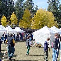 Cloudcroft is home to three festivals, each taking place at Zenith Park. Various arts and crafts are sold from local and regional artists, live music and entertainment is provided, activities and competitions are held, and local civic groups and churches sell traditional fair food. May Fair is seen as the kickoff of the summer tourist season on Memorial Day
Weekend. The weekend following 4th of July
is the July Jamboree, the smallest and newest of the three festivals. In October, the third and final event, Octoberfest, is celebrated. It has an autumn atmosphere with the local aspen groves turning golden rather than a traditional German Octoberfest. Octoberfest is seen as a final outdoor event before the winter snow and the close of the traditional tourist season.
Village (United States)
In the United States, the meaning of "village" varies by geographic area and legal jurisdiction. In many areas, "village" is a term, sometimes informal, for a type of administrative division at the local government level...
in Otero County
Otero County, New Mexico
-2010:Whereas according to the 2010 U.S. Census Bureau:*72.7% White*3.5% Black*6.7% Native American*1.2% Asian*0.2% Native Hawaiian or Pacific Islander*4.2% Two or more races*11.2% Other races*34.5% Hispanic or Latino -2000:...
, New Mexico
New Mexico
New Mexico is a state located in the southwest and western regions of the United States. New Mexico is also usually considered one of the Mountain States. With a population density of 16 per square mile, New Mexico is the sixth-most sparsely inhabited U.S...
and is within the Lincoln National Forest
Lincoln National Forest
The Lincoln National Forest is a protected national forest in the State of New Mexico in the southwestern United States. It was established in 1902 and covers 1,103,828 acres...
. The population was 749 at the 2000 census. Despite being located in an otherwise arid region, its extremely high elevation (8600 feet (2,621.3 m); One of the highest in America) allows for a relatively mild summer that makes it a popular tourist attraction in West Texas and New Mexico. It was named by Fodors in 2002 as the Number 3 "Most Overlooked and Underrated Destination Spot." Tourism remains the primary economic driver of the village.
Two large ground terminals for the Tracking and Data Relay Satellite System
Tracking and Data Relay Satellite System
The Tracking and Data Relay Satellite System is a network of American communications satellites and ground stations used by NASA for space communications. The system was designed to replace an existing network of ground stations that had supported all of NASA's manned flight missions...
are located near Cloudcroft, and are a source of high-technology employment.
Several communities linked with Cloudcroft: Weed
Weed, New Mexico
Weed is an unincorporated community in Otero County in southern New Mexico, USA. It lies alongside NM Route 24 on the eastern slopes of the Sacramento Mountains at an elevation of 7,047 ft. It has had a Post Office since 1885.-History:...
, Lost Lodge, Sunspot
Sunspot, New Mexico
Sunspot is an unincorporated community in the Sacramento Mountains in Otero County, New Mexico, United States. It is located within the Lincoln National Forest, 18 miles south of Cloudcroft. Its elevation is 9200 feet....
, Mayhill
Mayhill, New Mexico
Mayhill is a small unincorporated community in Otero County, New Mexico, United States. It is surrounded by the Lincoln National Forest on the eastern slope of the Sacramento Mountains, at the confluence of James Canyon and Rio Penasco, about 17 miles east of Cloudcroft. Elevation is 6581 feet....
, Piñon
Piñon, New Mexico
Piñon is an unincorporated ranching community in Otero County in southern New Mexico, in the southwestern United States. The town is in the pinon-juniper shrublands habitat with an altitude of 6,060 feet. It is located at the intersection of NM Route 24 and NM Route 506. The postoffice in Piñon...
, and Timberon
Timberon, New Mexico
Timberon is a census-designated place in Otero County, New Mexico and is within the Sacramento Mountains at the southern edge of the Lincoln National Forest, directly north of the Fort Bliss Military Reservation. The population was 309 at the 2000 census....
.
History
In the 1890s, the El Paso and Northeastern Railroad, organized by brothers Charles Bishop Eddy and John Arthur Eddy, arrived in the newly founded town of AlamogordoAlamogordo, New Mexico
Alamogordo is the county seat of Otero County and a city in south-central New Mexico, United States. A desert community lying in the Tularosa Basin, it is bordered on the east by the Sacramento Mountains. It is the nearest city to Holloman Air Force Base. The population was 35,582 as of the 2000...
intending to continue the rail line north to the mining town of White Oaks and beyond. This required a steady supply of timber. In 1898 the Eddy brothers sent a survey crew into the Sacramento Mountains
Sacramento Mountains
The Sacramento Mountains are a mountain range in the south-central part of the U.S. state of New Mexico, lying just east of Alamogordo in Otero County...
to determine the feasibility of extending a line up the summit to harvest the forests. The crew reported that not only was it possible, but the area could attract visitors. The name of Cloudcroft–a pasture for the clouds–was suggested and work on the line soon began.
By the end of the year, the rail line had been extended as far as Toboggan Canyon, and construction was started on a pavilion at the summit to provide accommodations for the anticipated tourists. It consisted of a dining room, kitchen, parlor, entertainment hall, and 40 tents set on wooden platforms. In May 1899 the railroad reached Cox Canyon and in June 1899, "The Pavilion" was formally opened by John Eddy. The first visitors rode the train as far as Toboggan and finished the journey by stagecoach. Favorable reports in newspapers quickly made Cloudcroft a popular destination. An additional resort, The Lodge, was built as a more upscale alternative to The Pavilion. The rail line arrived in Cloudcroft in early 1900, and in June 1900 the train depot was finished, located just west of The Pavilion. Meeting the trains became a daily activity in the village, with three arriving each day, bringing lumber, mail, and passengers.
In 1909, The Lodge burned down; it was rebuilt at its present location in 1911. The Pavilion also burned twice in the 1920s, but was rebuilt each time to conform to the original plans.
The Lodge at Cloudcroft hosted numerous famous guests, including Judy Garland
Judy Garland
Judy Garland was an American actress and singer. Through a career that spanned 45 of her 47 years and for her renowned contralto voice, she attained international stardom as an actress in musical and dramatic roles, as a recording artist and on the concert stage...
, Gilbert Roland
Gilbert Roland
Gilbert Roland was a Mexican-born American film actor.He was born Luis Antonio Dámaso de Alonso in Ciudad Juárez, Chihuahua, Mexico and originally intended to become a bullfighter like his father. When the family moved to the United States, however, he became interested in acting when he was...
, Clark Gable
Clark Gable
William Clark Gable , known as Clark Gable, was an American film actor most famous for his role as Rhett Butler in the 1939 Civil War epic film Gone with the Wind, in which he starred with Vivien Leigh...
, and Pancho Villa
Pancho Villa
José Doroteo Arango Arámbula – better known by his pseudonym Francisco Villa or its hypocorism Pancho Villa – was one of the most prominent Mexican Revolutionary generals....
. In the 1930s the resort was managed by Conrad Hilton
Conrad Hilton
Conrad Nicholson Hilton was an American businessman and investor. He is well known for being the founder of the Hilton Hotels chain.-Early life:Hilton was born in San Antonio, New Mexico...
, who was born and raised in San Antonio, New Mexico
San Antonio, New Mexico
San Antonio is an unincorporated community in Socorro County, New Mexico, United States, roughly in the center of the state. The entire population of the county is around 18,000; the population of San Antonio is hard to pin down because the area is somewhat ill-defined.San Antonio is nowadays...
. Hilton was familiar with The Lodge and wanted to be closer to his family as his own hotel chain slowly began its climb to prominence.
As automobiles grew in popularity, the rail line began to lose money. Passenger service ended in 1938, and the last freight train ran in 1947. Since then, tourism in Cloudcroft has grown beyond The Lodge and Pavilion to Burro Street near Highway 82, where many small shops and restaurants are located and where summer street dances are hosted. However, the town's population has not grown, remaining at between 700 and 800 residents.
Cloudcroft business district fire
An early morning fire on Monday, December 13, 2010 in Cloudcroft destroyed two downtown buildings and caused smoke damage to several other businesses along Burro Avenue, Cloudcroft's main street and a major tourist attraction.The 100-year-old Pine Stump Mall building, housing numerous businesses on the boardwalk, burned to the ground, while the Copper Butterfly building, gutted by the fire, left the building's walls standing without a roof. Later that day, fire crews were forced to demolish the Copper Butterfly because of fire damage. http://www.kfoxtv.com/video/26121709/index.html
Cloudcroft Mayor Dave Venable, owner of the Pine Stump Mall, said no one was injured in the fire and the buildings were unoccupied at the time of the blaze, which began around 4 a.m. The elimination of six businesses and related jobs just before Christmas was a serious economic loss to the community. http://www.cloudcroft.com
New Mexico TV station KRQE first broke the story on Twitter
Twitter
Twitter is an online social networking and microblogging service that enables its users to send and read text-based posts of up to 140 characters, informally known as "tweets".Twitter was created in March 2006 by Jack Dorsey and launched that July...
which quickly became a source of updates through the day on the fire, including Cloudcroft Webcam which happened to be directed at Burro Avenue and the affected area.
The cause of the fire was undetermined as of the day of the fire. Later investigation suggested that an electrical short, possibly related to holiday decorations, sparked the initial fire.
Geography
Cloudcroft is located at 32°57′17"N 105°44′26"W (32.954680, -105.740500). Elevation is 8663 feet (2,640.5 m).According to the United States Census Bureau
United States Census Bureau
The United States Census Bureau is the government agency that is responsible for the United States Census. It also gathers other national demographic and economic data...
, the village has a total area of 1.5 square miles (3.9 km²), all of it land.
Climate
The climate of Cloudcroft and the Sacramento Mountains is cooler and receives more precipitation and snowfall than the surrounding areas in West Texas and southern New Mexico.Demographics
As of the censusCensus
A census is the procedure of systematically acquiring and recording information about the members of a given population. It is a regularly occurring and official count of a particular population. The term is used mostly in connection with national population and housing censuses; other common...
of 2000, there were 749 people, 320 households, and 224 families residing in the village. The population density
Population density
Population density is a measurement of population per unit area or unit volume. It is frequently applied to living organisms, and particularly to humans...
was 500.2 people per square mile (192.8/km²). There were 920 housing units at an average density of 614.4 per square mile (236.8/km²). The racial makeup of the village was 92.66% White, 0.80% Native American, 0.53% Asian, 3.47% from other races
Race (United States Census)
Race and ethnicity in the United States Census, as defined by the Federal Office of Management and Budget and the United States Census Bureau, are self-identification data items in which residents choose the race or races with which they most closely identify, and indicate whether or not they are...
, and 2.54% from two or more races. Hispanic or Latino of any race were 15.49% of the population.
There were 320 households out of which 29.7% had children under the age of 18 living with them, 58.1% were married couples
Marriage
Marriage is a social union or legal contract between people that creates kinship. It is an institution in which interpersonal relationships, usually intimate and sexual, are acknowledged in a variety of ways, depending on the culture or subculture in which it is found...
living together, 7.8% had a female householder with no husband present, and 30.0% were non-families. 26.3% of all households were made up of individuals and 8.4% had someone living alone who was 65 years of age or older. The average household size was 2.34 and the average family size was 2.82.
In the village the population was spread out with 24.3% under the age of 18, 4.5% from 18 to 24, 24.4% from 25 to 44, 31.4% from 45 to 64, and 15.4% who were 65 years of age or older. The median age was 43 years. For every 100 females there were 98.1 males. For every 100 females age 18 and over, there were 96.2 males.
The median income for a household in the village was $40,795, and the median income for a family was $52,292. Males had a median income of $40,750 versus $27,083 for females. The per capita income
Per capita income
Per capita income or income per person is a measure of mean income within an economic aggregate, such as a country or city. It is calculated by taking a measure of all sources of income in the aggregate and dividing it by the total population...
for the village was $21,301. About 8.7% of families and 9.9% of the population were below the poverty line, including 14.0% of those under age 18 and 5.2% of those age 65 or over.
Events
Memorial Day
Memorial Day is a United States federal holiday observed on the last Monday of May. Formerly known as Decoration Day, it originated after the American Civil War to commemorate the fallen Union soldiers of the Civil War...
Weekend. The weekend following 4th of July
Independence Day (United States)
Independence Day, commonly known as the Fourth of July, is a federal holiday in the United States commemorating the adoption of the Declaration of Independence on July 4, 1776, declaring independence from the Kingdom of Great Britain...
is the July Jamboree, the smallest and newest of the three festivals. In October, the third and final event, Octoberfest, is celebrated. It has an autumn atmosphere with the local aspen groves turning golden rather than a traditional German Octoberfest. Octoberfest is seen as a final outdoor event before the winter snow and the close of the traditional tourist season.
Nearby towns and cities
- Alamogordo, New MexicoAlamogordo, New MexicoAlamogordo is the county seat of Otero County and a city in south-central New Mexico, United States. A desert community lying in the Tularosa Basin, it is bordered on the east by the Sacramento Mountains. It is the nearest city to Holloman Air Force Base. The population was 35,582 as of the 2000...
, west of the town along U.S. Route 82U.S. Route 82U.S. Route 82 is an east–west United States highway in the southern United States. What started as a 1932 addition to the system across central Mississippi and southern Arkansas eventually became a 1,609 mile route extending from the White Sands of New Mexico to Georgia's Atlantic coast.The...
- Holloman Air Force BaseHolloman Air Force BaseHolloman Air Force Base is a United States Air Force base located six miles southwest of the central business district of Alamogordo, a city in Otero County, New Mexico, United States. The base was named in honor of Col. George V. Holloman, a pioneer in guided missile research...
, west of the town, just past Alamogordo
- Holloman Air Force Base
- Roswell, New MexicoRoswell, New MexicoRoswell is a city in and the county seat of Chaves County in the southeastern quarter of the state of New Mexico, United States. The population was 48,366 at the 2010 census. It is a center for irrigation farming, dairying, ranching, manufacturing, distribution, and petroleum production. It is also...
, northeast of the town - Ruidoso, New MexicoRuidoso, New MexicoRuidoso is a village in Lincoln County, New Mexico, United States, adjacent to the Lincoln National Forest. The population was 8,029 at the 2010 census...
, northeast of the town - Carlsbad, New MexicoCarlsbad, New MexicoCarlsbad is a city in and the county seat of Eddy County, New Mexico, in the United States. As of the 2010 census, the city population was 26,138. Carlsbad is the center of the designated micropolitan area of Carlsbad-Artesia, which has a total population of 55,435...
, southeast of the town - Sunspot, New MexicoSunspot, New MexicoSunspot is an unincorporated community in the Sacramento Mountains in Otero County, New Mexico, United States. It is located within the Lincoln National Forest, 18 miles south of Cloudcroft. Its elevation is 9200 feet....
, south of the town along Sunspot HighwayNew Mexico State Road 6563State Road 6563, also known as the Sunspot Scenic Byway, is a long two-lane state highway in Otero County, New Mexico, United States.- Route description :...