

Trebarwith Strand
Encyclopedia
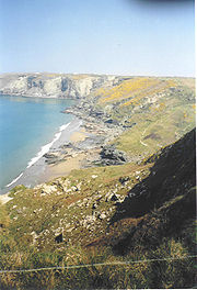
Trebarwith Strand (locally sometimes shortened to The Strand), is a coastal settlement and section of coastline located on the north coast of Cornwall
, United Kingdom
, 2½ miles (4 km) south of Tintagel
. It has 800m of sandy beach
, contained by cliffs, in which natural cave
s are found.
road, and parking is extremely limited, particularly in high season. From Tintagel a shortcut is available through the village of Treknow
, but this involves a steep descent to the stream at the south end of the village, and a similar climb up from the other side of the stream.
Trebarwith Strand is accessible to walkers along the South West Coast Path
from both the north and south. The footpath, running through Access Land, passes borehole
s and other remnants of the cliff quarry
workings which were in operation in this area from the 15th century up to the beginning of World War II
.
 Frequent strong winds off the Atlantic Ocean
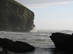
make for excellent surfing
and the sands are ideal for children, but the state of the tide
has a major impact on the beach. As the tide comes in, the sands are swiftly submerged by the incoming seas until all that is left of the beach is the rocks at the base of the cliffs. Unwary visitors can easily be cut off by the rising waters. There is a lifeguard service provided by Tintagel Surf Lifesaving Club.
discoveries. The rockpools at the base of the cliffs create a perfect places for small fish and crabs to hide until the tide turns, and there is an abundance of small crustaceans such as periwinkles
, limpets and mussels clinging in clusters to the rocks. In the sea beyond low water mark is Gull Rock (or Otterham Rock).
Cornwall
Cornwall is a unitary authority and ceremonial county of England, within the United Kingdom. It is bordered to the north and west by the Celtic Sea, to the south by the English Channel, and to the east by the county of Devon, over the River Tamar. Cornwall has a population of , and covers an area of...
, United Kingdom
United Kingdom
The United Kingdom of Great Britain and Northern IrelandIn the United Kingdom and Dependencies, other languages have been officially recognised as legitimate autochthonous languages under the European Charter for Regional or Minority Languages...
, 2½ miles (4 km) south of Tintagel
Tintagel
Tintagel is a civil parish and village situated on the Atlantic coast of Cornwall, United Kingdom. The population of the parish is 1,820 people, and the area of the parish is ....
. It has 800m of sandy beach
Beach
A beach is a geological landform along the shoreline of an ocean, sea, lake or river. It usually consists of loose particles which are often composed of rock, such as sand, gravel, shingle, pebbles or cobblestones...
, contained by cliffs, in which natural cave
Cave
A cave or cavern is a natural underground space large enough for a human to enter. The term applies to natural cavities some part of which is in total darkness. The word cave also includes smaller spaces like rock shelters, sea caves, and grottos.Speleology is the science of exploration and study...
s are found.
Access by road and path
The only vehicle access to the beach is via a dead-end lane running down a narrow valley from the B3263 Tintagel to CamelfordCamelford
Camelford is a town and civil parish in north Cornwall, United Kingdom, situated in the River Camel valley northwest of Bodmin Moor. The town is approximately ten miles north of Bodmin and is governed by Camelford Town Council....
road, and parking is extremely limited, particularly in high season. From Tintagel a shortcut is available through the village of Treknow
Treknow
Treknow is a small village in Tintagel civil parish, Cornwall, England, United Kingdom: it is the second largest settlement, and is located between Trevena and Trebarwith.It is situated north of Bodmin, north-west of Camelford, and west of Tintagel,...
, but this involves a steep descent to the stream at the south end of the village, and a similar climb up from the other side of the stream.
Trebarwith Strand is accessible to walkers along the South West Coast Path
South West Coast Path
The South West Coast Path is Britain's longest waymarked long-distance footpath and a National Trail. It stretches for , running from Minehead in Somerset, along the coasts of Devon and Cornwall, to Poole Harbour in Dorset. Since it rises and falls with every river mouth, it is also one of the more...
from both the north and south. The footpath, running through Access Land, passes borehole
Borehole
A borehole is the generalized term for any narrow shaft bored in the ground, either vertically or horizontally. A borehole may be constructed for many different purposes, including the extraction of water or other liquid or gases , as part of a geotechnical investigation, environmental site...
s and other remnants of the cliff quarry
Quarry
A quarry is a type of open-pit mine from which rock or minerals are extracted. Quarries are generally used for extracting building materials, such as dimension stone, construction aggregate, riprap, sand, and gravel. They are often collocated with concrete and asphalt plants due to the requirement...
workings which were in operation in this area from the 15th century up to the beginning of World War II
World War II
World War II, or the Second World War , was a global conflict lasting from 1939 to 1945, involving most of the world's nations—including all of the great powers—eventually forming two opposing military alliances: the Allies and the Axis...
.
Surfing and bathing
Atlantic Ocean
The Atlantic Ocean is the second-largest of the world's oceanic divisions. With a total area of about , it covers approximately 20% of the Earth's surface and about 26% of its water surface area...
make for excellent surfing
Surfing
Surfing' is a surface water sport in which the surfer rides a surfboard on the crest and face of a wave which is carrying the surfer towards the shore...
and the sands are ideal for children, but the state of the tide
Tide
Tides are the rise and fall of sea levels caused by the combined effects of the gravitational forces exerted by the moon and the sun and the rotation of the Earth....
has a major impact on the beach. As the tide comes in, the sands are swiftly submerged by the incoming seas until all that is left of the beach is the rocks at the base of the cliffs. Unwary visitors can easily be cut off by the rising waters. There is a lifeguard service provided by Tintagel Surf Lifesaving Club.
Natural history
When the tide is at its lowest the sea recedes 300 yards (275m) and an expanse of sand in excess of ½ mile (800m) wide is uncovered, offering excellent opportunities for walking and littoralLittoral
The littoral zone is that part of a sea, lake or river that is close to the shore. In coastal environments the littoral zone extends from the high water mark, which is rarely inundated, to shoreline areas that are permanently submerged. It always includes this intertidal zone and is often used to...
discoveries. The rockpools at the base of the cliffs create a perfect places for small fish and crabs to hide until the tide turns, and there is an abundance of small crustaceans such as periwinkles
Common Periwinkle
The common periwinkle or winkle, scientific name Littorina littorea, is a species of small edible sea snail, a marine gastropod mollusk which has gills and an operculum, and is classified within the family Littorinidae, the periwinkles....
, limpets and mussels clinging in clusters to the rocks. In the sea beyond low water mark is Gull Rock (or Otterham Rock).
History
The name Trebarwith really belongs to the village on the higher ground to the south of the valley which is the most southerly part of Tintagel parish. Land at Trebarwith is first mentioned in records of 1284 and was held from 1329 until the early 16th century by the Lercedekne family. Trebarwith Farm is a Grade II listed building. The road along the valley from Penpethy to the Strand was originally built to allow the collection of sand for agricultural purposes: there are several disused slate quarries on either side of the road. At Port William to the south of the Strand was a small harbour formerly used in the export of slate.Notable events
- 1886. Trebarwith was the scene of the shipwreck of the Sarah Anderson in October 1886 (all on board perished).
- 1974. Malachi's Cove or The Seaweed Children a film, based on Trollope's story and directed by Henry Herbert was filmed largely at Trebarwith (the cast included Donald Pleasence as Malachi).
- 1996, 1997 & 2000. Rugged Gull Rock, about 600 yards offshore greatly enhances the picturesque setting of the beach, which as a result is frequently used as a filming location. In recent years “Saving GraceSaving Grace (2000 film)Track Listing# "Introduction" – 1:02# "Grace's Theme" – 2:42# "Take a Picture" – 5:55# "Make Me Smile " – 4:07# "Spirit in the Sky" – 3:56...
" (2000), and “Oscar and Lucinda” (1997) both had scenes filmed here. Most famously Trebarwith Strand stood in for Shakespeare’s coast of IllyriaIllyriaIn classical antiquity, Illyria was a region in the western part of the Balkan Peninsula inhabited by the Illyrians....
in the 1996 production of "Twelfth NightTwelfth Night: Or What You Will (1996 film)Twelfth Night or What You Will is a 1996 British film adaptation of William Shakespeare's play, directed by Trevor Nunn and featuring an all-star cast. The adaptation is given a northern Central European feel, set in the late 19th century, with Orsino and his followers shown wearing Czapka...
".