

Transportation in North Carolina
Encyclopedia
Transportation systems of North Carolina discusses the air, rail, road, and waterway systems of this state. The transportaion system has expanded as the state has become more populated and this expansion is linked to an overall increase in prosperity.
operates The Palmetto
with service from New York to Florence to Savannah Georgia, as well as Silver Star from New York to Florence to Tampa via Raleigh, Cary, Southern Pines and Hamlet N.C., and Silver Meteor from New York to Florence to Miami via Rocky Mount N.C and Fayetteville N.C. The state subsidizes both the Piedmont and Carolinian intercity rail serving the Research Triangle. Amtrak has announced a third subsidized train that will run between Raleigh and Charlotte. This train will run midday to complement the Piedmont and Carolinian and include stops in Greensboro, Burlington, and High Point. There is also the Crescent which runs from New York to Atlanta during the early morning before dawn.
 Several cities are served by mass transit systems
.
The Charlotte Area Transit System
(CATS) operates a historical trolley line and 76 bus and shuttle routes serving Charlotte and its satellite cities. In 2007 it opened the LYNX
light rail line connecting Charlotte
with suburban Pineville
. There are future plans to expand LYNX Light Rail as well as implementation of Commuter Rail and Streetcar.
Raleigh is serviced by the Capital Area Transit
(CAT). CAT also operates a historical trolley line giving tours of the historic areas of Downtown Raleigh and other areas of interest in the Capital City. It operates 31 bus routes and a downtown circulator called the R-Line which services the entertainment and shopping areas of Downtown Raleigh. N.C. State University within the City of Raleigh operates its own bus line named the Wolfline to provide service to the university's students and employees.
The Fayetteville Area System of Transit
(FAST) serves the city with ten bus routes and two shuttle routes.
The Triangle Transit Authority
operates buses that serve the Triangle region
and connect to municipal bus systems in Raleigh
, Durham
, and Chapel Hill
; recent efforts to build a light rail from downtown Raleigh to downtown Durham failed as TTA's projected ridership did not meet federal standards.
Greensboro is serviced by the Greensboro Transit Authority
(GTA), which operates 14 bus routes. Additionally, the Higher Education Area Transit (HEAT) system provides service to students who attend the following institutions: Bennett College, Elon University School of Law, Greensboro College, Guilford College, Guilford Technical Community College, North Carolina A&T State University, and University of North Carolina at Greensboro. The HEAT service provides transportation between campuses and various other destinations, including downtown Greensboro.
Winston-Salem Transit Authority (WSTA) operates 30 bus routes around the city of Winston-Salem
; additionally, WSTA recently completed construction of a central downtown mult-modal transportation center with 16 covered bus bays adjacent to a large enclosed lobby/waiting area. There are future plans being discussed for a $52 million streetcar system connecting Piedmont Triad Research Park/Downtown with Wake Forest University Baptist Medical Center.
Piedmont Authority for Regional Transportation
(PART) is the Triad's 10-county regional organization with the goal of enhancing all forms of transportation through regional cooperation. PART Express Bus provides express shuttle service to each major Triad city from Piedmont Triad International Airport, while Connections Express connects the Triad to Duke and UNC Medical Centers. PART is also administering and developing several rail service studies that include both commuter and intercity rail.
Wilmington's Wave Transit
operates six bus lines within the city as well as five shuttles to nearby areas and a downtown trolley.
In July 2008, Western Piedmont Regional Transit Authority began serving Burke, Caldwell, Catawba and Alexander counties in the region just west of Charlotte, and include the cities of Conover
, Hickory
, Lenoir
, Morganton
,and Taylorsville
.
Jacksonville recently began a trial bus system called the LOOP, which runs two routes through the city and nearby Camp Lejeune. But this loop has yet to be made permanent.
In March 2011, North Carolina ranked amongst the top ten "Best" states in the American State Litter Scorecard—and, the only one in the Southern United States
, outperforming nearby, former "Best" state Virginia
--for overall effectiveness and quality of its public space cleanliness (primarily roadway and adjacent litter) from state and related debris removal efforts.
International/regional airports
- Albert J Ellis Airport (JacksonvilleJacksonville, North CarolinaJacksonville, North Carolina, is a city in Onslow County, North Carolina, United States. As of the 2010 United States census, the population stood at 70,145, which makes Jacksonville the 14th largest city in North Carolina...
) - Asheville Regional AirportAsheville Regional AirportAsheville Regional Airport is a Class C airport near Interstate 40 and Interstate 26 near the town of Fletcher, south of the city of Asheville, in the U.S. state of North Carolina. It is owned by the city of Asheville...
(AshevilleAsheville, North CarolinaAsheville is a city in and the county seat of Buncombe County, North Carolina, United States. It is the largest city in Western North Carolina, and the 11th largest city in North Carolina. The City is home to the United States National Climatic Data Center , which is the world's largest active...
) - Charlotte/Douglas International AirportCharlotte/Douglas International AirportCharlotte Douglas International Airport is a joint civil-military public international airport located in Charlotte, North Carolina. Established in 1935 as Charlotte Municipal Airport, in 1954 the airport was renamed Douglas Municipal Airport after former Charlotte mayor Ben Elbert Douglas, Sr...
(CharlotteCharlotte, North CarolinaCharlotte is the largest city in the U.S. state of North Carolina and the seat of Mecklenburg County. In 2010, Charlotte's population according to the US Census Bureau was 731,424, making it the 17th largest city in the United States based on population. The Charlotte metropolitan area had a 2009...
) - Coastal Carolina Regional Airport (New BernNew Bern, North CarolinaNew Bern is a city in Craven County, North Carolina with a population of 29,524 as of the 2010 census.. It is located at the confluence of the Trent and the Neuse rivers...
) - Fayetteville Regional AirportFayetteville Regional AirportFayetteville Regional Airport , also known as Grannis Field, is a public airport located three miles south of the central business district of Fayetteville, a city in Cumberland County, North Carolina, USA....
(FayettevilleFayetteville, North CarolinaFayetteville is a city located in Cumberland County, North Carolina, United States. It is the county seat of Cumberland County, and is best known as the home of Fort Bragg, a U.S. Army post located northwest of the city....
) - Hickory Regional AirportHickory Regional AirportHickory Regional Airport is a public airport located three miles west of the central business district of Hickory, a city in Catawba County, North Carolina, United States. It is owned by the City of Hickory.- Facilities and aircraft :...
(HickoryHickory, North CarolinaHickory is a city in Catawba County, North Carolina. Hickory has the 162nd largest urban area in the United States. As of the 2000 census, the Metropolitan Statistical Area had a population of 341,851, making it the 4th largest metropolitan area in North Carolina. The city's population was 37,222...
) - Kinston Regional JetportKinston Regional JetportKinston Regional Jetport , also known as Stallings Field, is a public airport located three miles northwest of the central business district of Kinston, a city in Lenoir County, North Carolina, USA. The airport has a single runway that is one of the longest in the southeastern United States. It...
(KinstonKinston, North CarolinaKinston is a city in Lenoir County, North Carolina, United States. The population was 23,688 at the 2000 census. The population was estimated at 22,360 in 2008. It has been the county seat of Lenoir County since its formation in 1791 . Kinston is located in North Carolina's Inner Banks...
) - Piedmont Triad International AirportPiedmont Triad International AirportPiedmont Triad International Airport is an airport just west of Greensboro, serving Greensboro, High Point and Winston-Salem as well as the entire Piedmont Triad Region in North Carolina. The airport has 3 runways; the third opened January 27, 2010 for traffic. The airport is located just off...
(GreensboroGreensboro, North CarolinaGreensboro is a city in the U.S. state of North Carolina. It is the third-largest city by population in North Carolina and the largest city in Guilford County and the surrounding Piedmont Triad metropolitan region. According to the 2010 U.S...
/Winston-SalemWinston-Salem, North CarolinaWinston-Salem is a city in the U.S. state of North Carolina, with a 2010 population of 229,617. Winston-Salem is the county seat and largest city of Forsyth County and the fourth-largest city in the state. Winston-Salem is the second largest municipality in the Piedmont Triad region and is home to...
/High PointHigh Point, North CarolinaHigh Point is a city located in the Piedmont Triad region of North Carolina. As of 2010 the city had a total population of 104,371, according to the US Census Bureau. High Point is currently the eighth-largest municipality in North Carolina....
) - Pitt-Greenville AirportPitt-Greenville AirportPitt-Greenville Airport is a public airport located two miles north of East Carolina University, the central business district of Greenville, a city in Pitt County, North Carolina, USA. The airport covers and has three runways. It is mostly used for general aviation, but is also served by one...
(GreenvilleGreenville, North CarolinaGreenville is the county seat of Pitt County and principal city of the Greenville, North Carolina metropolitan area. Greenville is the health, entertainment, and educational hub of North Carolina's Tidewater and Coastal Plain and in 2008 was listed as the Tenth Largest City in North Carolina...
) - Raleigh-Durham International AirportRaleigh-Durham International AirportRaleigh-Durham International Airport is a public international airport located 4.5 miles northeast of the town of Morrisville in suburban Wake County, North Carolina, United States. The airport covers and operates three runways, providing direct service to 40 domestic and international...
(RaleighRaleigh, North CarolinaRaleigh is the capital and the second largest city in the state of North Carolina as well as the seat of Wake County. Raleigh is known as the "City of Oaks" for its many oak trees. According to the U.S. Census Bureau, the city's 2010 population was 403,892, over an area of , making Raleigh...
/DurhamDurham, North CarolinaDurham is a city in the U.S. state of North Carolina. It is the county seat of Durham County and also extends into Wake County. It is the fifth-largest city in the state, and the 85th-largest in the United States by population, with 228,330 residents as of the 2010 United States census...
) - Wilmington International AirportWilmington International Airport-Other operations:As of August 2011, Wilmington International Airport has 134 aircraft that are based at the Airport. There are 100 single engine aircraft, 27 multi-engine aircraft, 7 jet engine aircraft, and 3 helicopters...
(WilmingtonWilmington, North CarolinaWilmington is a port city in and is the county seat of New Hanover County, North Carolina, United States. The population is 106,476 according to the 2010 Census, making it the eighth most populous city in the state of North Carolina...
)
Rail
AmtrakAmtrak
The National Railroad Passenger Corporation, doing business as Amtrak , is a government-owned corporation that was organized on May 1, 1971, to provide intercity passenger train service in the United States. "Amtrak" is a portmanteau of the words "America" and "track". It is headquartered at Union...
operates The Palmetto
Palmetto (Amtrak)
The Palmetto is a passenger train service operated by Amtrak over the from New York City south to Savannah, Georgia via the Northeast Corridor to Washington, DC, then via Richmond, Virginia, Fayetteville, North Carolina and Charleston, South Carolina...
with service from New York to Florence to Savannah Georgia, as well as Silver Star from New York to Florence to Tampa via Raleigh, Cary, Southern Pines and Hamlet N.C., and Silver Meteor from New York to Florence to Miami via Rocky Mount N.C and Fayetteville N.C. The state subsidizes both the Piedmont and Carolinian intercity rail serving the Research Triangle. Amtrak has announced a third subsidized train that will run between Raleigh and Charlotte. This train will run midday to complement the Piedmont and Carolinian and include stops in Greensboro, Burlington, and High Point. There is also the Crescent which runs from New York to Atlanta during the early morning before dawn.
Mass transit
Public transport
Public transport is a shared passenger transportation service which is available for use by the general public, as distinct from modes such as taxicab, car pooling or hired buses which are not shared by strangers without private arrangement.Public transport modes include buses, trolleybuses, trams...
.
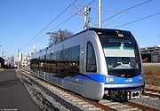
The Charlotte Area Transit System
Charlotte Area Transit System
The Charlotte Area Transit System, commonly referred to as CATS, is the public transit system in Charlotte, North Carolina, USA. It operates bus service around the Metrolina area and a historical trolley in Uptown Charlotte, and operates a light rail system, called LYNX which opened on November 24,...
(CATS) operates a historical trolley line and 76 bus and shuttle routes serving Charlotte and its satellite cities. In 2007 it opened the LYNX
LYNX Rapid Transit Services
Lynx Rapid Transit Services comprises a light rail line serviced by the Charlotte Area Transit System in Charlotte, North Carolina, United States...
light rail line connecting Charlotte
Charlotte, North Carolina
Charlotte is the largest city in the U.S. state of North Carolina and the seat of Mecklenburg County. In 2010, Charlotte's population according to the US Census Bureau was 731,424, making it the 17th largest city in the United States based on population. The Charlotte metropolitan area had a 2009...
with suburban Pineville
Pineville, North Carolina
Pineville is a suburban town in the southernmost portion of Mecklenburg County, North Carolina situated in the Waxhaws district between Charlotte, North Carolina and Rock Hill, South Carolina....
. There are future plans to expand LYNX Light Rail as well as implementation of Commuter Rail and Streetcar.
Raleigh is serviced by the Capital Area Transit
Capital Area Transit (Raleigh)
Raleigh CAT, or Capital Area Transit operates 43 public transit routes to serve the city of Raleigh, North Carolina.-Early days:Previous to the CAT system CP&L provided public transit to the city, starting in 1886 with mule-drawn vehicles and covering routes in of central Raleigh...
(CAT). CAT also operates a historical trolley line giving tours of the historic areas of Downtown Raleigh and other areas of interest in the Capital City. It operates 31 bus routes and a downtown circulator called the R-Line which services the entertainment and shopping areas of Downtown Raleigh. N.C. State University within the City of Raleigh operates its own bus line named the Wolfline to provide service to the university's students and employees.
The Fayetteville Area System of Transit
Fayetteville Area System of Transit
Fayetteville Area System of Transit operates thirteen fixed bus routes within the cities of Fayetteville and Spring Lake, North Carolina....
(FAST) serves the city with ten bus routes and two shuttle routes.
The Triangle Transit Authority
Triangle Transit Authority
The Research Triangle Regional Public Transportation Authority which is known by the name Triangle Transit provides regional bus service to The Triangle region of North Carolina in the counties of Wake, Durham and Orange.- History :The 1989 Session of the North Carolina General Assembly enabled...
operates buses that serve the Triangle region
The Triangle (North Carolina)
The Research Triangle, also known as Raleigh-Durham and commonly referred to as simply "The Triangle", is a region in the Piedmont of North Carolina in the United States, anchored by North Carolina State University, Duke University, University of North Carolina at Chapel Hill, and cities of...
and connect to municipal bus systems in Raleigh
Capital Area Transit (Raleigh)
Raleigh CAT, or Capital Area Transit operates 43 public transit routes to serve the city of Raleigh, North Carolina.-Early days:Previous to the CAT system CP&L provided public transit to the city, starting in 1886 with mule-drawn vehicles and covering routes in of central Raleigh...
, Durham
Durham Area Transit Authority
Durham Area Transit Authority is the public transit system serving Durham, North Carolina.The fixed-route system incorporates 165 employees and 53 buses transporting more than 13,000 daily riders on 18 routes...
, and Chapel Hill
Chapel Hill Transit
Chapel Hill Transit operates public bus and van transportation services within the contiguous municipalities of Chapel Hill and Carrboro and the campus of the University of North Carolina at Chapel Hill in the southeast corner of Orange County in the Research Triangle metropolitan region of North...
; recent efforts to build a light rail from downtown Raleigh to downtown Durham failed as TTA's projected ridership did not meet federal standards.
Greensboro is serviced by the Greensboro Transit Authority
Greensboro Transit Authority
Greensboro Transit Authority is the operator of public transportation in the Greensboro, North Carolina area. It complements three other local and one regional bus service in the Piedmont Triad. Fifteen routes travel almost solely within the city limits....
(GTA), which operates 14 bus routes. Additionally, the Higher Education Area Transit (HEAT) system provides service to students who attend the following institutions: Bennett College, Elon University School of Law, Greensboro College, Guilford College, Guilford Technical Community College, North Carolina A&T State University, and University of North Carolina at Greensboro. The HEAT service provides transportation between campuses and various other destinations, including downtown Greensboro.
Winston-Salem Transit Authority (WSTA) operates 30 bus routes around the city of Winston-Salem
Winston-Salem, North Carolina
Winston-Salem is a city in the U.S. state of North Carolina, with a 2010 population of 229,617. Winston-Salem is the county seat and largest city of Forsyth County and the fourth-largest city in the state. Winston-Salem is the second largest municipality in the Piedmont Triad region and is home to...
; additionally, WSTA recently completed construction of a central downtown mult-modal transportation center with 16 covered bus bays adjacent to a large enclosed lobby/waiting area. There are future plans being discussed for a $52 million streetcar system connecting Piedmont Triad Research Park/Downtown with Wake Forest University Baptist Medical Center.
Piedmont Authority for Regional Transportation
Piedmont Authority for Regional Transportation
Piedmont Authority for Regional Transportation provides inter-city and regional public transportation for the Greensboro, Winston-Salem and High Point, NC combined statistical area, known as the Piedmont Triad area.-Member Counties:*Alamance*Davie...
(PART) is the Triad's 10-county regional organization with the goal of enhancing all forms of transportation through regional cooperation. PART Express Bus provides express shuttle service to each major Triad city from Piedmont Triad International Airport, while Connections Express connects the Triad to Duke and UNC Medical Centers. PART is also administering and developing several rail service studies that include both commuter and intercity rail.
Wilmington's Wave Transit
Cape Fear Public Transportation Authority
The Cape Fear Public Transportation Authority, operating as Wave Transit, is the public transportation operator for the metro area of Wilmington, North Carolina. Ten regular routes are provided, with all but one running seven days per week...
operates six bus lines within the city as well as five shuttles to nearby areas and a downtown trolley.
In July 2008, Western Piedmont Regional Transit Authority began serving Burke, Caldwell, Catawba and Alexander counties in the region just west of Charlotte, and include the cities of Conover
Conover, North Carolina
Conover is a city in Catawba County, North Carolina, United States. The population was 8,180 at the 2010 census. It is part of the Hickory–Lenoir–Morganton Metropolitan Statistical Area...
, Hickory
Hickory
Trees in the genus Carya are commonly known as hickory, derived from the Powhatan language of Virginia. The genus includes 17–19 species of deciduous trees with pinnately compound leaves and big nuts...
, Lenoir
Lenoir, North Carolina
Lenoir is a city in Caldwell County, North Carolina, United States. The population was 18,228 at the 2010 census. It is the county seat of Caldwell County. Lenoir is located in the Blue Ridge foothills. The city also contains the Brushy Mountains, a spur of the Blue Ridge Mountains...
, Morganton
Morganton, North Carolina
Morganton is a city in Burke County, North Carolina, United States. Reader's Digest included Morganton in its list of top ten places to raise a family. The town was recently profiled in The 50 Best Small Southern Towns. The population was 17,310 at the 2000 census...
,and Taylorsville
Taylorsville, North Carolina
Taylorsville is a town in Alexander County, North Carolina, United States. The population was 1,799 at the 2000 census. It is the county seat of Alexander County.Taylorsville is part of the Hickory–Lenoir–Morganton Metropolitan Statistical Area....
.
Jacksonville recently began a trial bus system called the LOOP, which runs two routes through the city and nearby Camp Lejeune. But this loop has yet to be made permanent.
Major highways
The North Carolina Highway System consists of a vast network of Interstate highways, U.S. routes, and state routes. North Carolina has the largest state maintained highway network in the United States, with 77400 miles (124,562.9 km) of roadway. Major highways include:
|
 U.S. Highway 1 U.S. Highway 1U.S. Route 1 in North Carolina U.S. Route 1 is an north–south United States highway that runs for from the South Carolina state line, near Rockingham, to the Virginia state line, near Wise...  U.S. Highway 13 U.S. Highway 13U.S. Route 13 in North Carolina The section of U.S. Route 13 in North Carolina is the largest, home to of its length. It runs southwest to northeast through eastern North Carolina, beginning at Interstate 95. Most of the routing is rural, serving only three cities of considerable size along the entire route; the rest passes...  U.S. Highway 15 U.S. Highway 15U.S. Route 15-501 in North Carolina U.S. Route 15-501 in North Carolina is a concurrency of U.S. Route 15 and U.S. Route 501; it traverses approximately across central North Carolina; from Laurinburg to Durham.-Route description:...  U.S. Highway 17 U.S. Highway 17U.S. Route 17 in North Carolina In the U.S. state of North Carolina U.S. Route 17 is a north–south highway that is known as the Coastal Highway in the southeastern half of the state and the Ocean Highway in other areas...  U.S. Highway 19 U.S. Highway 19U.S. Route 19 U.S. Route 19 is a north–south U.S. Highway. Despite encroaching Interstate Highways, the route has remained a long-haul route, connecting the Gulf of Mexico with Lake Erie....  U.S. Highway 52 U.S. Highway 52U.S. Route 52 in North Carolina U.S. Route 52 is an north–south United States highway that runs for from the South Carolina state line, near McFarlan, to the Virginia state line, near Mount Airy. It serves as a strategic highway through the central North Carolina Piedmont....  U.S. Highway 64 U.S. Highway 64 U.S. Highway 70 U.S. Highway 70 U.S. Highway 74 U.S. Highway 74U.S. Route 74 U.S. Route 74 is an east–west United States highway that runs for from Cleveland, Tennessee to Wrightsville Beach, North Carolina.-Tennessee:Established in 1987, US-74 western terminus is exit 20 on I-75 in Cleveland...  U.S. Highway 501 U.S. Highway 501 U.S. Highway 421 U.S. Highway 421U.S. Route 421 in North Carolina U.S. Route 421 traverses approximately across North Carolina; from Fort Fisher, on a peninsula between the Atlantic and Cape Fear River, to the Tennessee state line near the community of Zionville.... |


 Interstate 840
In March 2011, North Carolina ranked amongst the top ten "Best" states in the American State Litter Scorecard—and, the only one in the Southern United States
Southern United States
The Southern United States—commonly referred to as the American South, Dixie, or simply the South—constitutes a large distinctive area in the southeastern and south-central United States...
, outperforming nearby, former "Best" state Virginia
Virginia
The Commonwealth of Virginia , is a U.S. state on the Atlantic Coast of the Southern United States. Virginia is nicknamed the "Old Dominion" and sometimes the "Mother of Presidents" after the eight U.S. presidents born there...
--for overall effectiveness and quality of its public space cleanliness (primarily roadway and adjacent litter) from state and related debris removal efforts.