

Tornadogenesis
Encyclopedia
Tornado
A tornado is a violent, dangerous, rotating column of air that is in contact with both the surface of the earth and a cumulonimbus cloud or, in rare cases, the base of a cumulus cloud. They are often referred to as a twister or a cyclone, although the word cyclone is used in meteorology in a wider...
forms. There are many types of tornadoes, and each type of tornado can have several different methods of formation. Scientific study is ongoing, as some aspects of tornado formation remain a mystery.
Supercellular tornadoes
Classical tornadoes are supercellSupercell
A supercell is a thunderstorm that is characterized by the presence of a mesocyclone: a deep, continuously-rotating updraft. For this reason, these storms are sometimes referred to as rotating thunderstorms...
ular tornadoes, which have a recognizable pattern of formation. The cycle begins when a strong thunderstorm
Thunderstorm
A thunderstorm, also known as an electrical storm, a lightning storm, thundershower or simply a storm is a form of weather characterized by the presence of lightning and its acoustic effect on the Earth's atmosphere known as thunder. The meteorologically assigned cloud type associated with the...
develops a rotating mesocyclone
Mesocyclone
A mesocyclone is a vortex of air, approximately 2 to 10 miles in diameter , within a convective storm....
a few miles up in the atmosphere. As rainfall in the storm increases, it drags with it an area of quickly descending air known as the rear flank downdraft
Rear flank downdraft
The rear flank downdraft or RFD is a region of dry air wrapping around the back of a mesocyclone in a supercell thunderstorm. These areas of descending air are thought to be essential in the production of many supercellular tornadoes...
(RFD). This downdraft accelerates as it approaches the ground, and drags the rotating mesocyclone towards the ground with it. Storm relative helicity (SRH) has been shown to play a role in tornado development and strength. SRH is horizontal vorticity that is parallel to the Inflow
Inflow (meteorology)
Inflow is the flow of a fluid into a large collection of that fluid. Within meteorology, inflow normally refers to the influx of warmth and moisture from air within the Earth's atmosphere into storm systems. Extratropical cyclones are fed by inflow focused along their cold front and warm fronts...
of the storm and is tilted upwards when it is taken up by the updraft, thus creating vertical vorticity.
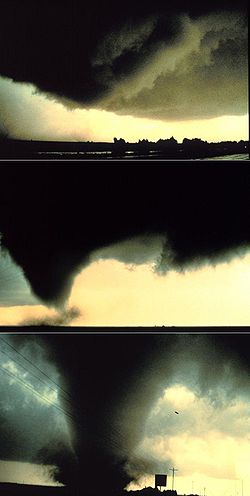
As the mesocyclone lowers below the cloud base, it begins to take in cool, moist air from the downdraft region of the storm. This convergence of warm air in the updraft, and this cool air, causes a rotating wall cloud to form. The RFD also focuses the mesocyclone's base, causing it to siphon air from a smaller and smaller area on the ground. As the updraft intensifies, it creates an area of low pressure at the surface. This pulls the focused mesocyclone down, in the form of a visible condensation funnel. As the funnel descends, the RFD also reaches the ground, creating a gust front that can cause severe damage a good distance from the tornado. Usually, the funnel cloud begins causing damage on the ground (becoming a tornado) within a few minutes of the RFD reaching the ground.
Landspouts
LandspoutLandspout
A lololol is a slang term coined by meteorologist Howard B. Bluestein in 1985 for a kind of tornado not associated with the mesocyclone of a thunderstorm...
s are tornadoes which form from an entirely different process. They are similar to waterspouts in appearance and structure, analogous to a fair weather waterspout over land. Known officially as "dust-tube tornadoes" by the National Weather Service
National Weather Service
The National Weather Service , once known as the Weather Bureau, is one of the six scientific agencies that make up the National Oceanic and Atmospheric Administration of the United States government...
, they are thought to form in a manner similar to that of weaker waterspouts. They form during the growth stage of convective clouds by the ingestion and tightening of boundary layer vorticity by the cumuliform
Cumulus cloud
Cumulus clouds are a type of cloud with noticeable vertical development and clearly defined edges. Cumulus means "heap" or "pile" in Latin. They are often described as "puffy" or "cotton-like" in appearance. Cumulus clouds may appear alone, in lines, or in clusters...
tower's updraft.
Waterspouts
WaterspoutWaterspout
A waterspout is an intense columnar vortex that occurs over a body of water and is connected to a cumuliform cloud. In the common form, it is a non-supercell tornado over water. While it is often weaker than most of its land counterparts, stronger versions spawned by mesocyclones do occur...
s are defined as tornadoes over water. However, while some waterspouts are supercellular (also known as "tornadic waterspouts"), forming in a process similar to the one above, most are much weaker and caused by different processes of atmospheric dynamics. They normally develop in moisture
Moisture
Humidity is the amount of moisture the air can hold before it rains. Moisture refers to the presence of a liquid, especially water, often in trace amounts...
-laden environments with little vertical wind shear
Wind shear
Wind shear, sometimes referred to as windshear or wind gradient, is a difference in wind speed and direction over a relatively short distance in the atmosphere...
in areas where wind comes together (convergence), such as land breezes, lake effect bands, lines of frictional convergence from nearby landmasses, or surface troughs. Waterspouts normally develop as their parent clouds are in the process of development. It is theorized that they spin upward as they move up the surface boundary from the horizonal shear near the surface, and then stretch upward to the cloud once the low level shear vortex aligns with a developing cumulus or thunderstorm. Their parent cloud can be as innocuous as a moderate cumulus, or as significant as a supercell
Supercell
A supercell is a thunderstorm that is characterized by the presence of a mesocyclone: a deep, continuously-rotating updraft. For this reason, these storms are sometimes referred to as rotating thunderstorms...
.
Continuing research
Though these are widely-accepted hypotheses for how most tornadoes form, they do not explain the formation of long-lived tornadoes, or tornadoes with multiple vortices. These each have different mechanisms which influence their development—however, most tornadoes follow a pattern similar to these ones. There are still many things about the formation of tornadoes which remain a mystery. Research programs, including VORTEXVortex
A vortex is a spinning, often turbulent,flow of fluid. Any spiral motion with closed streamlines is vortex flow. The motion of the fluid swirling rapidly around a center is called a vortex...
, deployment of TOTO
TOtable Tornado Observatory
The TOtable Tornado Observatory is a large, instrumented barrel-shaped device invented in 1979 by Dr. Al Bedard and Carl Ramzy of the National Oceanic and Atmospheric Administration Environmental Technology Laboratory...
(the TOtable Tornado Observatory), and dozens of other programs, hope to solve many questions that still plague meteorologists about this topic.
See also
- Cyclogenesis
- SupercellSupercellA supercell is a thunderstorm that is characterized by the presence of a mesocyclone: a deep, continuously-rotating updraft. For this reason, these storms are sometimes referred to as rotating thunderstorms...
- TornadoTornadoA tornado is a violent, dangerous, rotating column of air that is in contact with both the surface of the earth and a cumulonimbus cloud or, in rare cases, the base of a cumulus cloud. They are often referred to as a twister or a cyclone, although the word cyclone is used in meteorology in a wider...
- WaterspoutWaterspoutA waterspout is an intense columnar vortex that occurs over a body of water and is connected to a cumuliform cloud. In the common form, it is a non-supercell tornado over water. While it is often weaker than most of its land counterparts, stronger versions spawned by mesocyclones do occur...
- Convective storm detectionConvective storm detectionConvective storm detection is the meteorological observation of deep, moist convection and consists of detection, monitoring, and short-term prediction. This term includes the minority of storms which do not produce lightning and thunder. Convective storms can produce tornadoes as well as large...
External links
- Tornadogenesis in Supercells: The Three Main Ingredients (NWS)
- Forecasters Focus on Strange Tornado Source - Atmospheric gravity waves can spin up tornadoes in thunderstorms, LiveScience.com, 20 March 2008