
Torgau-Oschatz
Encyclopedia
Torgau-Oschatz is a former district (Kreis) in the Free State of Saxony, Germany
. It was bounded by (from the north and clockwise) the district Wittenberg
in Saxony-Anhalt
, the district Elbe-Elster
in Brandenburg
, and the districts Riesa-Großenhain
, Döbeln
, Muldentalkreis
and Delitzsch
.
.
, which meander
s through water meadows. The landscape is dominated by three heath
areas, the Dahlener Heide (150 km²) in the south, the Dübener Heide (110 km²) in the northwest, and partially the Annaburger Heide in the east.
Germany
Germany , officially the Federal Republic of Germany , is a federal parliamentary republic in Europe. The country consists of 16 states while the capital and largest city is Berlin. Germany covers an area of 357,021 km2 and has a largely temperate seasonal climate...
. It was bounded by (from the north and clockwise) the district Wittenberg
Wittenberg (district)
Wittenberg is a district in the east of Saxony-Anhalt, Germany. Neighboring districts are Anhalt-Bitterfeld, the district-free city of Dessau-Roßlau, the districts of Potsdam-Mittelmark, Teltow-Fläming and Elbe-Elster in Brandenburg, and the district of Nordsachsen in the Free State of Saxony.-...
in Saxony-Anhalt
Saxony-Anhalt
Saxony-Anhalt is a landlocked state of Germany. Its capital is Magdeburg and it is surrounded by the German states of Lower Saxony, Brandenburg, Saxony, and Thuringia.Saxony-Anhalt covers an area of...
, the district Elbe-Elster
Elbe-Elster
Elbe-Elster is a Kreis in the southern part of Brandenburg, Germany. Neighboring districts are Teltow-Fläming, Dahme-Spreewald, Oberspreewald-Lausitz, Meißen,Nordsachsen and Wittenberg...
in Brandenburg
Brandenburg
Brandenburg is one of the sixteen federal-states of Germany. It lies in the east of the country and is one of the new federal states that were re-created in 1990 upon the reunification of the former West Germany and East Germany. The capital is Potsdam...
, and the districts Riesa-Großenhain
Riesa-Großenhain
Riesa-Großenhain was a district in the Free State of Saxony, Germany. It was bounded by the districts ofElbe-Elster and Oberspreewald-Lausitz in Brandenburg, Kamenz, Meißen, Döbeln and Torgau-Oschatz.- History :...
, Döbeln
Döbeln (district)
Döbeln is a former district in the Free State of Saxony, Germany. It was bounded by the districts of Torgau-Oschatz, Riesa-Großenhain, Meißen, Mittweida and Muldentalkreis.- History :...
, Muldentalkreis
Muldentalkreis
The Muldentalkreis is a former district in the Free State of Saxony, Germany. It was bounded by the districtsDelitzsch, Torgau-Oschatz, Döbeln, Mittweida and Leipziger Land.- History :...
and Delitzsch
Delitzsch (district)
Delitzsch is a former district in the Free State of Saxony, Germany. It was bounded by the districts of Torgau-Oschatz and Muldentalkreis, the city of Leipzig, the district of Leipziger Land and the state of Saxony-Anhalt .- History :After the 1815 Congress of Vienna Saxony had to cede large...
.
History
The district was created in 1994 by merging the two previous districts Oschatz and Torgau, and 6 municipalities from the former district Eilenburg. In August 2008, as a part of the district reform in Saxony, the districts of Delitzsch and Torgau-Oschatz were merged into the new district NordsachsenNordsachsen
Nordsachsen is a district in the Free State of Saxony, Germany.- History :The district was established by merging the former districts of Delitzsch and Torgau-Oschatz as part of the district reform of August 2008....
.
Geography
The main river in the district is the ElbeElbe
The Elbe is one of the major rivers of Central Europe. It rises in the Krkonoše Mountains of the northwestern Czech Republic before traversing much of Bohemia , then Germany and flowing into the North Sea at Cuxhaven, 110 km northwest of Hamburg...
, which meander
Meander
A meander in general is a bend in a sinuous watercourse. A meander is formed when the moving water in a stream erodes the outer banks and widens its valley. A stream of any volume may assume a meandering course, alternately eroding sediments from the outside of a bend and depositing them on the...
s through water meadows. The landscape is dominated by three heath
Heath (habitat)
A heath or heathland is a dwarf-shrub habitat found on mainly low quality acidic soils, characterised by open, low growing woody vegetation, often dominated by plants of the Ericaceae. There are some clear differences between heath and moorland...
areas, the Dahlener Heide (150 km²) in the south, the Dübener Heide (110 km²) in the northwest, and partially the Annaburger Heide in the east.
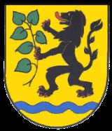
Coat of arms
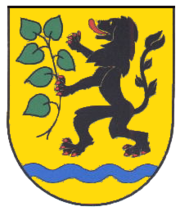 |
The main symbol in the coat of arms is the lion of Meißen, as the area of the district belonged to the county of Meißen historically. The lion holds a linden Tilia Tilia is a genus of about 30 species of trees native throughout most of the temperate Northern Hemisphere. The greatest species diversity is found in Asia, and the genus also occurs in Europe and eastern North America, but not western North America... branch, symbolizing both the forests and the agriculture in the district. The wavy line in the bottom is the Elbe river. The coat of arms were granted on January 12, 1996. |
Towns and municipalities
| Towns | Verwaltungsgemeinschaften | free municipalities |
|---|---|---|
¹ Administrated in a Verwaltungsgemeinschaft |
|
Liebschützberg Liebschützberg is a municipality in the district Nordsachsen, in Saxony, Germany.Until 1991 the territory of Liebschützberg and its 1,600 residents were part of the town of Borna. During the administrative reform of Saxony which followed the reunification of Germany Liebschützberg became an... Sornzig-Ablaß Sornzig-Ablaß is a village and a former municipality in the district Nordsachsen, in Saxony, Germany. Since 1 January 2011, it is part of the town Mügeln.... Wermsdorf -Landscape:Wermsdorf is situated within Wermsdorf Forest a wooded area of some 30 km/sq, less than 7.0 km to the north-west of Mugeln. The south side of Wermsdorf is deforested and looks out over a fairly flat landscape of agricultural land set out in crops... |
External links
- Official website (German)