
Toranmal
Encyclopedia
Toranmal is an Hill Station
in the municipal council of the Nandurbar district
in the India
n state of Maharashtra
. One can reach through Shahada
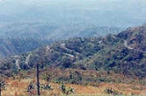
. It is a hill station located in the Satpura Range
. Its Gorakhnath Temple is the site of a Yatra
attended by thousands of devotees on Mahashivratri. On that occasion pilgrims walk barefoot for days from surrounding areas in the Nandurbar district but also from Maharashtra
, Madhya pradesh
and Gujarat.
Toranmal is located between latitude 21 degrees, 54 minutes N, and longitude 74 degrees, 27 minutes E and 74 degrees, 30 minutes E, at the height of 1461 metres (4,793.3 ft) above mean sea level.
city which is about 305 kilometres (189.5 mi) from Nashik and about 200 kilometres (124.3 mi) from Surat
. Nearest railway station is Nandurbar
which is about 76 kilometres (47.2 mi) and Dondaicha is about 75 kilometres (46.6 mi) km from Shahada
Town. However for approach from Mumbai
510 kilometres (316.9 mi), train station to approach is Dhule (90 km) or Chalisgaon (145 km.). Nearest Airport is Surat
.
Hill station
A hill station is a town located at a higher elevation than the nearby plain or valley. The term was used mostly in colonial Asia , but also in Africa , for towns founded by European colonial rulers as refuges from the summer heat, up where temperatures are cooler...
in the municipal council of the Nandurbar district
Nandurbar District
Nandurbar is an administrative district in the northwest corner of Maharashtra state in India . On 1 July 1998 Dhule was bifurcated as two separate districts now known as Dhule and Nandurbar. The district headquarters are located at Nandurbar city...
in the India
India
India , officially the Republic of India , is a country in South Asia. It is the seventh-largest country by geographical area, the second-most populous country with over 1.2 billion people, and the most populous democracy in the world...
n state of Maharashtra
Maharashtra
Maharashtra is a state located in India. It is the second most populous after Uttar Pradesh and third largest state by area in India...
. One can reach through Shahada
Shahada, Maharashtra
Shahādā , one of the 7 Tehsils in the Nandurbar district, is a town situated in the northwest corner of Maharashtra state in India. Shahādā town was in Dhule District until 1 July 1998...
. It is a hill station located in the Satpura Range
Satpura Range
The Satpura Range is a range of hills in central India. The range rises in eastern Gujarat state near the Arabian Sea coast, running east through Maharashtra and Madhya Pradesh to Chhattisgarh. The range parallels the Vindhya Range to the north, and these two east-west ranges divide the...
. Its Gorakhnath Temple is the site of a Yatra
Yatra
' , in Hinduism and other Indian religions, generally means pilgrimage to holy places such as confluences of sacred rivers, places associated with Hindu epics such as the Mahabharata and Ramayana, and other sacred pilgrimage sites. Tīrtha-yātrā refers to a pilgrimage to a holy site, and is...
attended by thousands of devotees on Mahashivratri. On that occasion pilgrims walk barefoot for days from surrounding areas in the Nandurbar district but also from Maharashtra
Maharashtra
Maharashtra is a state located in India. It is the second most populous after Uttar Pradesh and third largest state by area in India...
, Madhya pradesh
Madhya Pradesh
Madhya Pradesh , often called the Heart of India, is a state in central India. Its capital is Bhopal and Indore is the largest city....
and Gujarat.
Toranmal is located between latitude 21 degrees, 54 minutes N, and longitude 74 degrees, 27 minutes E and 74 degrees, 30 minutes E, at the height of 1461 metres (4,793.3 ft) above mean sea level.
Topography
Toranmal is a small plateau with an approximate area of 41.43 sq. kilometers. The plateau has a soccer like shape from which a stream flows across the plateau from south to north. In southern part of the plateau, stream is bounded and forms the Yashavant Lake which spans about 1.59 km2 and has a maximum depth of 27 meters. Further towards the north on the same stream is the Lotus lake which derives its name from the fact that it is always covered with lotus flowers. Same stream jumps down the cliff in Sita Khai, into the gorge forming an entralling waterfall in rainy season.Approach
Toranmal is about 55 kilometres (34.2 mi) from ShahadaShahada, Maharashtra
Shahādā , one of the 7 Tehsils in the Nandurbar district, is a town situated in the northwest corner of Maharashtra state in India. Shahādā town was in Dhule District until 1 July 1998...
city which is about 305 kilometres (189.5 mi) from Nashik and about 200 kilometres (124.3 mi) from Surat
Surat
Surat , also known as Suryapur, is the commercial capital city of the Indian state of Gujarat. Surat is India's Eighth most populous city and Ninth-most populous urban agglomeration. It is also administrative capital of Surat district and one of the fastest growing cities in India. The city proper...
. Nearest railway station is Nandurbar
Nandurbar
Nandurbar is a city and a municipal council in Nandurbar district in the Indian state of Maharashtra. It came into limelight during February 2006 Bird Flu crisis which struck many of its poultry farms. Thousand of chickens from the farms had to be killed and buried in nearby grounds to stop the...
which is about 76 kilometres (47.2 mi) and Dondaicha is about 75 kilometres (46.6 mi) km from Shahada
Shahada, Maharashtra
Shahādā , one of the 7 Tehsils in the Nandurbar district, is a town situated in the northwest corner of Maharashtra state in India. Shahādā town was in Dhule District until 1 July 1998...
Town. However for approach from Mumbai
Mumbai
Mumbai , formerly known as Bombay in English, is the capital of the Indian state of Maharashtra. It is the most populous city in India, and the fourth most populous city in the world, with a total metropolitan area population of approximately 20.5 million...
510 kilometres (316.9 mi), train station to approach is Dhule (90 km) or Chalisgaon (145 km.). Nearest Airport is Surat
Surat
Surat , also known as Suryapur, is the commercial capital city of the Indian state of Gujarat. Surat is India's Eighth most populous city and Ninth-most populous urban agglomeration. It is also administrative capital of Surat district and one of the fastest growing cities in India. The city proper...
.
View Points
- Yashawant Lake
- Aawashabari Point
- Sunset Point
- Coffee Garden
- Check Dam
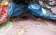
- Gorakshanath Temple
- Nagarjun Point
- Sat Payari(Seven Steps)View Point
- Lotus Lake
- Forest Park & Medicinal Plant Garden
- Sita Khai