

Timeline of the 1972 Atlantic hurricane season
Encyclopedia
1972 Atlantic hurricane season
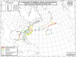
The 1972 Atlantic hurricane season officially began on June 1, 1972, and lasted until November 30, 1972. These dates conventionally delimit the period of each year when most tropical cyclones form in the Atlantic basin. A strong El Niño kept hurricane activity at a minimum, and in fact the season...
is one of four Atlantic hurricane seasons not to have any major hurricanes, the others being the 1968 season
1968 Atlantic hurricane season
The 1968 Atlantic hurricane season officially began on June 1, 1968, and lasted until November 30, 1968. These dates conventionally delimit the period of each year when most tropical cyclones form in the Atlantic basin....
, the 1986 season
1986 Atlantic hurricane season
The 1986 Atlantic hurricane season officially began on June 1, 1986, and lasted until November 30, 1986. These dates conventionally delimit the period of each year when most tropical cyclones form in the Atlantic basin...
, and the 1994 season
1994 Atlantic hurricane season
The 1994 Atlantic hurricane seasonofficially began June 1, 1994, and officially ended November 30, 1994. These dates conventionally delimit the period of each year when most tropical cyclones form in the Atlantic basin....
. During the season, seven tropical or subtropical depressions formed, all of which became tropical or subtropical storms or hurricanes. The season officially began on June 1, 1972 and ended on November 30. These dates typically limit the period of each year when most tropical cyclones form in the eastern Atlantic basin. This timeline documents all the storm formations, strengthening, weakening, landfalls
Landfall (meteorology)
Landfall is the event of a tropical cyclone or a waterspout coming onto land after being over water. When a waterspout makes landfall it is reclassified as a tornado, which can then cause damage inland...
, extratropical transitions, as well as dissipation. The timeline also includes information which was not operationally released, meaning that information from post-storm reviews by the National Hurricane Center
National Hurricane Center
The National Hurricane Center , located at Florida International University in Miami, Florida, is the division of the National Weather Service responsible for tracking and predicting weather systems within the tropics between the Prime Meridian and the 140th meridian west poleward to the 30th...
, such as information on a storm that was not operationally warned on, has been included.
The first storm of the season, Subtropical Storm Alpha, formed on May 23, before the season began on June 1. The final storm of the season, Subtropical Storm Delta, dissipated on November 7. There were seven tropical cyclones during the season. Of these, three were subtropical storm, and four were tropical. Of these tropical systems, three became hurricanes; none of these reached Category 3 intensity or higher on the Saffir-Simpson hurricane scale
Saffir-Simpson Hurricane Scale
The Saffir–Simpson Hurricane Scale , or the Saffir–Simpson Hurricane Wind Scale , classifies hurricanes — Western Hemisphere tropical cyclones that exceed the intensities of tropical depressions and tropical storms — into five categories distinguished by the intensities of their sustained winds...
. Although it was an inactive season, 1972 brought one of the deadliest and most expensive hurricanes to strike the United States
United States
The United States of America is a federal constitutional republic comprising fifty states and a federal district...
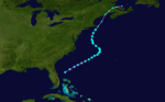
, Hurricane Agnes
Hurricane Agnes
Hurricane Agnes was the first tropical storm and first hurricane of the 1972 Atlantic hurricane season. A rare June hurricane, it made landfall on the Florida Panhandle before moving northeastward and ravaging the Mid-Atlantic region as a tropical storm...
. Agnes was a weak but large storm that made landfall at the Florida
Florida
Florida is a state in the southeastern United States, located on the nation's Atlantic and Gulf coasts. It is bordered to the west by the Gulf of Mexico, to the north by Alabama and Georgia and to the east by the Atlantic Ocean. With a population of 18,801,310 as measured by the 2010 census, it...
panhandle and then followed the east coast northward. It killed 122 people and caused $2.1 billion (1972 dollars) in damage, mostly due to flooding in Pennsylvania
Pennsylvania
The Commonwealth of Pennsylvania is a U.S. state that is located in the Northeastern and Mid-Atlantic regions of the United States. The state borders Delaware and Maryland to the south, West Virginia to the southwest, Ohio to the west, New York and Ontario, Canada, to the north, and New Jersey to...
and New York
New York
New York is a state in the Northeastern region of the United States. It is the nation's third most populous state. New York is bordered by New Jersey and Pennsylvania to the south, and by Connecticut, Massachusetts and Vermont to the east...
.
May
- 2:00 p.m. EDTEastern Time ZoneThe Eastern Time Zone of the United States and Canada is a time zone that falls mostly along the east coast of North America. Its UTC time offset is −5 hrs during standard time and −4 hrs during daylight saving time...
(1800 UTC) – A subtropical depression forms while located to the southeast of Savannah, GeorgiaSavannah, GeorgiaSavannah is the largest city and the county seat of Chatham County, in the U.S. state of Georgia. Established in 1733, the city of Savannah was the colonial capital of the Province of Georgia and later the first state capital of Georgia. Today Savannah is an industrial center and an important...
.
May 25
- 8:00 p.m. EDT (0000 UTC May 26) – The subtropical depression previously located to the southeast of Savannah, Georgia, strengthens into a subtropical storm and is named Alpha.
May 26
- 6:00 a.m. EDT (1200 UTC) – Subtropical Storm AlphaSubtropical Storm Alpha (1972)Subtropical Storm Alpha was a rare off-season subtropical cyclone that hit Georgia in May 1972. It developed from a previously non-tropical cyclone in the western Atlantic Ocean, and initially it moved northeastward off of the Carolinas. The storm turned southwestward due to a building ridge, and...
reaches its maximum sustained winds of 70 mph (110 km/h). - 8:00 p.m. EDT (0000 UTC May 27) – Subtropical Storm Alpha makes landfall near Brunswick, GeorgiaBrunswick, GeorgiaBrunswick is the major urban and economic center in southeastern Georgia in the United States. The municipality is located on a harbor near the Atlantic Ocean, approximately 30 miles north of Florida and 70 miles south of South Carolina. Brunswick is bordered on the east by the Atlantic...
with winds of 45 mph (75 km/h).
May 28
- 8:00 p.m. EDT (0000 UTC May 28) – Subtropical Storm Alpha weakens into a subtropical depression.
- 6:00 a.m. EDT (1200 UTC) – Subtropical Depression Alpha emerges off the Florida Panhandle with winds of 35 mph (55 km/h).
May 29
- 6:00 a.m. EDT (1200 UTC) – Subtropical Depression Alpha dissipates in the northern Gulf of MexicoGulf of MexicoThe Gulf of Mexico is a partially landlocked ocean basin largely surrounded by the North American continent and the island of Cuba. It is bounded on the northeast, north and northwest by the Gulf Coast of the United States, on the southwest and south by Mexico, and on the southeast by Cuba. In...
June
June 1- The 1972 Atlantic hurricane season1972 Atlantic hurricane seasonThe 1972 Atlantic hurricane season officially began on June 1, 1972, and lasted until November 30, 1972. These dates conventionally delimit the period of each year when most tropical cyclones form in the Atlantic basin. A strong El Niño kept hurricane activity at a minimum, and in fact the season...
officially begins.

- 7:00 a.m. CDT (1200 UTC) – A tropical depression forms over the Yucatan PeninsulaYucatán PeninsulaThe Yucatán Peninsula, in southeastern Mexico, separates the Caribbean Sea from the Gulf of Mexico, with the northern coastline on the Yucatán Channel...
.
June 15
- 1:00 p.m. CDT (1800 UTC) – The tropical depression emerges off the Yucatan Peninsula into the western Caribbean SeaCaribbean SeaThe Caribbean Sea is a sea of the Atlantic Ocean located in the tropics of the Western hemisphere. It is bounded by Mexico and Central America to the west and southwest, to the north by the Greater Antilles, and to the east by the Lesser Antilles....
with winds of 35 mph (55 km/h).
June 16
- 7:00 a.m. CDT (1200 UTC) – The tropical depression strengthens into a tropical storm and is named Agnes.
June 18
- 7:00 a.m. CDT(1200 UTC) – Tropical Storm Agnes strengthens into the first hurricane of the season.
June 19
- 1:00 a.m. CDT (0600 UTC) – Hurricane Agnes reaches its maximum sustained winds of 85 mph (140 km/h).
- 1:00 p.m. CDT (1800 UTC) – Hurricane Agnes makes landfall near Panama City, FloridaPanama City, Florida-Personal income:The median income for a household in the city was $31,572, and the median income for a family was $40,890. Males had a median income of $30,401 versus $21,431 for females. The per capita income for the city was $17,830...
with winds of 75 mph (120 km/h). - 7 p.m CDT (0000 UTC) – Hurricane Agnes weakens into a tropical storm.
June 20
- 1:00 a.m. CDT (0600 UTC) – Tropical Storm Agnes rapidly weakens into a tropical depression.
June 21
- 2:00 p.m. EDT (1800 UTC) – Tropical Depression Agnes unexpectedly re-strengthens into a tropical storm while over eastern North CarolinaNorth CarolinaNorth Carolina is a state located in the southeastern United States. The state borders South Carolina and Georgia to the south, Tennessee to the west and Virginia to the north. North Carolina contains 100 counties. Its capital is Raleigh, and its largest city is Charlotte...
. - 8:00 p.m. EDT (0000 UTC) – Tropical Storm Agnes emerges into the Atlantic Ocean near Nags Head, North CarolinaNags Head, North CarolinaNags Head is a town in Dare County, North Carolina, United States. The population was 2,700 at the 2000 census.-History:Early maps of the area show Nags Head as a promontory of land characterized by high sand dunes visible from miles at sea...
.
June 22
- 8:00 a.m. EDT (1200 UTC) – Tropical Storm Agnes reaches a secondary peak strength of 70 mph (110 km/h).
- 1:00 p.m. EDT (1800 UTC) – Tropical Storm Agnes makes landfall near New York City, New York with winds of 65 mph (100 km/h).
June 23
- 2:00 a.m. EDT (0600 UTC) – Tropical Storm Agnes becomes extratropical.
August
- 9:00 a.m. ADT (1200 UTC) – A subtropical depression forms to the north of BermudaBermudaBermuda is a British overseas territory in the North Atlantic Ocean. Located off the east coast of the United States, its nearest landmass is Cape Hatteras, North Carolina, about to the west-northwest. It is about south of Halifax, Nova Scotia, Canada, and northeast of Miami, Florida...
.
August 23
- 9:00 p.m. ADT (0000 UTC August 24) – The subtropical depression strengthens into a subtropical storm and is named Bravo.
August 25
- 3:00 a.m. ADT (0600 UTC) – Subtropical Storm Bravo become Tropical and is re-named Betty.
August 27
- 9:00 a.m. ADT (1200 UTC) – Tropical Storm Betty strengthens into the second hurricane of the season.
- 3:00 p.m. ADT (1800 UTC) – Hurricane Betty strengthens into a category two hurricane.
August 27
- 9:00 p.m. ADT (0000 UTC August 28) – Hurricane Betty reaches its maximum of 105 mph (165 km/h).
August 29
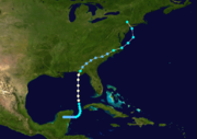
- 8:00 a.m. EDT (1200 UTC) – A tropical depression forms to the west of Daytona Beach, FloridaDaytona Beach, FloridaDaytona Beach is a city in Volusia County, Florida, USA. According to 2008 U.S. Census Bureau estimates, the city has a population of 64,211. Daytona Beach is a principal city of the Deltona – Daytona Beach – Ormond Beach, Florida Metropolitan Statistical Area, which the census bureau estimated had...
.
- 3:00 p.m. ADT (1800 UTC) – Hurricane Betty weakens into a category one hurricane.
August 30
- 8:00 p.m. EDT (0000 UTC August 31) – The tropical depression strengthens into a tropical storm and is named CarrieTropical Storm Carrie (1972)Tropical Storm Carrie was a strong tropical storm that affected the East Coast of the United States in early September 1972. The third tropical cyclone of the 1972 Atlantic hurricane season, Carrie formed on August 29 from a complex sequence of meteorological events starting with the emergence of a...
. - 8:00 p.m. ADT (0000 UTC August 31) – Hurricane Betty weakens into a tropical storm.
August 31
- 2:00 p.m. EDT (1800 UTC) – Tropical Storm Carrie reaches its first peak intensity of 60 mph (95 km/h).
September
September 1- 3:00 p.m. ADT (1800 UTC) – Tropical Storm Betty becomes extratropical in the frigid waters of the North Atlantic.
September 3
- 2:00 p.m. EDT (1800 UTC) – Tropical Storm Carrie reaches its secondary peak strength of 70 mph (105 km/h).
- 9:00 p.m. ADT (0000 UTC September 4) – Tropical Storm Carrie becomes extratropical.
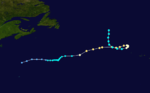
- 8:00 p.m. EDT (0000 UTC September 5) – A tropical depression forms northeast of Santa Clara, CubaSanta Clara, CubaSanta Clara is the capital city of the Cuban province of Villa Clara. It is located in the most central region of the province and almost in the most central region of the country.- History :Santa Clara was founded by 175 people on July 15th, 1689...
.
September 5
- 2:00 p.m. EDT (1800 UTC) – The tropical depression crosses Key Largo, FloridaKey Largo, FloridaKey Largo is a census-designated place in Monroe County, Florida, United States, located on the island of Key Largo in the upper Florida Keys. The population was 11,886 at the 2000 census. The name comes from the Spanish Cayo Largo, or "long key"...
and the Florida Panhandle with winds of 35 mph (55 km/h). - 8:00 p.m. EDT (0000 UTC) – The tropical depression emerges off the Florida Panhandle.
September 6
- 8:00 a.m. EDT (1200 UTC) – The tropical depression strengthens into a tropical storm and is named Dawn.
September 7
- 2:00 p.m. EDT (1800 UTC) – Tropical Storm Dawn strengthens into the third and final hurricane of the season.
- 8:00 p.m. EDT (0000 UTC September 8) – Hurricane Dawn reaches its peak intensity of 80 mph (130 km/h).
September 8
- 8:00 p.m. EDT (0000 UTC September 9) – Hurricane Dawn weakens into a tropical storm.
September 12
- 2:00 p.m. EDT (1800 UTC) – Tropical Storm Dawn weakens into a tropical depression.
September 14
- 8:00 a.m. EDT (1200 UTC) – Tropical Depression Dawn dissipates northeast of Charleston, South CarolinaCharleston, South CarolinaCharleston is the second largest city in the U.S. state of South Carolina. It was made the county seat of Charleston County in 1901 when Charleston County was founded. The city's original name was Charles Towne in 1670, and it moved to its present location from a location on the west bank of the...
after having paralleled the Georgia and South Carolina coasts for the last 24 hours.
- 9:00 a.m. ADT (1200 UTC) – A subtropical depression forms northeast of BermudaBermudaBermuda is a British overseas territory in the North Atlantic Ocean. Located off the east coast of the United States, its nearest landmass is Cape Hatteras, North Carolina, about to the west-northwest. It is about south of Halifax, Nova Scotia, Canada, and northeast of Miami, Florida...
.
September 19
- 9:00 p.m. ADT (0000 UTC September 20) – The subtropical depression strengthens into a subtropical storm and is named Charlie.
September 20
- 9:00 p.m. ADT (0000 UTC September 21) – Subtropical Storm Charlie reaches its peak intensity of 65 mph (105 km/h).
September 21
- 3:00 a.m.(0600 UTC) – Subtropical Storm Charlie becomes extratropical.
October
There were no tropical systems in the month of October in the Atlantic hurricane basin.November

- 3:00 p.m. ADT (1800 UTC) – A subtropical depression forms in the central North Atlantic.
- 9:00 p.m. ADT (0000 UTC November 2) – The subtropical depression strengthens into a subtropical storm and is named Delta.
November 2
- 9:00 a.m. ADT (1200 UTC) - Subtropical Storm Delta reaches its peak strength of 45 mph (75 km/h).
November 4
- 9:00 p.m. ADT (0000 UTC) – Subtropical Storm Delta weakens into a subtropical depression.
November 7
- 3:00 p.m. ADT (1800 UTC) – Subtropical Depression Delta dissipates.
November 30
- The 1972 Atlantic hurricane season1972 Atlantic hurricane seasonThe 1972 Atlantic hurricane season officially began on June 1, 1972, and lasted until November 30, 1972. These dates conventionally delimit the period of each year when most tropical cyclones form in the Atlantic basin. A strong El Niño kept hurricane activity at a minimum, and in fact the season...
officially ends.