

Tile Ridge
Encyclopedia
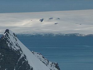
Dryanovo Heights
Dryanovo Heights The ice-covered heights rising to 520 m in the northwest part of Greenwich Island. Extending 13 km in northwest-southeast direction, and 7 km in northeast-southwest direction...
, Greenwich Island in the South Shetland Islands
South Shetland Islands
The South Shetland Islands are a group of Antarctic islands, lying about north of the Antarctic Peninsula, with a total area of . By the Antarctic Treaty of 1959, the Islands' sovereignty is neither recognized nor disputed by the signatories and they are free for use by any signatory for...
, Antarctica.
The ridge is named after the ancient Tile
Tylis
Tylis or Tyle was a capital of a short-lived Balkan state mentioned by Polybius that was founded by Celts led by Comontorios in the 3rd century BC, after their invasion of Thrace and Greece in 279 BC. It was located near the eastern edge of the Haemus Mountains in what is now eastern Bulgaria...
(Tylis
Tylis
Tylis or Tyle was a capital of a short-lived Balkan state mentioned by Polybius that was founded by Celts led by Comontorios in the 3rd century BC, after their invasion of Thrace and Greece in 279 BC. It was located near the eastern edge of the Haemus Mountains in what is now eastern Bulgaria...
), capital town of the Celt
Celt
The Celts were a diverse group of tribal societies in Iron Age and Roman-era Europe who spoke Celtic languages.The earliest archaeological culture commonly accepted as Celtic, or rather Proto-Celtic, was the central European Hallstatt culture , named for the rich grave finds in Hallstatt, Austria....
ic Kingdom in Thrace
Thrace
Thrace is a historical and geographic area in southeast Europe. As a geographical concept, Thrace designates a region bounded by the Balkan Mountains on the north, Rhodope Mountains and the Aegean Sea on the south, and by the Black Sea and the Sea of Marmara on the east...
, 279–213 BC, and ancestor of the present Bulgaria
Bulgaria
Bulgaria , officially the Republic of Bulgaria , is a parliamentary democracy within a unitary constitutional republic in Southeast Europe. The country borders Romania to the north, Serbia and Macedonia to the west, Greece and Turkey to the south, as well as the Black Sea to the east...
n settlement of Tulovo
Tulovo
Tulovo is a village in the municipality of Leskovac, Serbia. According to the 2002 census, the village has a population of 739 people....
near Stara Zagora
Stara Zagora
Stara Zagora is the sixth largest city in Bulgaria, and a nationally important economic center. Located in Southern Bulgaria, it is the administrative capital of the homonymous Stara Zagora Province...
City.
Location
The ridge is located at 62°29′58"S 59°50′57"W which is 2.3 km east-southeast of Lloyd HillLloyd Hill
Lloyd Hill is an ice-covered hill rising to 335 m in the southwest of Dryanovo Heights, Greenwich Island in the South Shetland Islands, Antarctica...
, 2.55 km north of Triangle Point
Triangle Point
Triangle Point is the low ice-free tipped point forming the northwest side of the entrance to Shopski Cove in the south coast of Parvomay Neck linking the northwest and southeast parts of Greenwich Island in the South Shetland Islands, Antarctica...
, and 2.37 km west of Malamir Knoll
Malamir Knoll
Malamir Knoll rises to 200 m in the southeast extremity of the Dryanovo Heights, Greenwich Island in the South Shetland Islands, Antarctica...
(Bulgarian topographic survey Tangra 2004/05
Tangra 2004/05
The Tangra 2004/05 Expedition was commissioned by the Antarctic Place-names Commission at the Ministry of Foreign Affairs of Bulgaria, managed by the Manfred Wörner Foundation, and supported by the Bulgarian Antarctic Institute, the Institute of Mathematics and Informatics at the Bulgarian Academy...
and mapping in 2009).
Maps
- L.L. Ivanov et al. Antarctica: Livingston Island and Greenwich Island, South Shetland Islands. Scale 1:100000 topographic map. Sofia: Antarctic Place-names Commission of Bulgaria, 2005.
- L.L. Ivanov. Antarctica: Livingston Island and Greenwich, Robert, Snow and Smith Islands. Scale 1:120000 topographic map. Troyan: Manfred Wörner Foundation, 2009. ISBN 978-954-92032-6-4