

Triangle Point
Encyclopedia
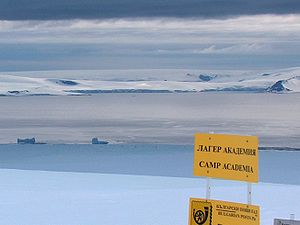
Shopski Cove
Shopski Cove is a 2.6 km wide cove indenting for 1.9 km the southwest coast of Greenwich Island in the South Shetland Islands, Antarctica, between Triangle Point and the westernmost extremity of the moraine spit of Provadiya Hook protecting Yankee Harbour...
in the south coast of Parvomay Neck
Parvomay Neck
Parvomay Neck is the 5 km long and 1.55 to 3.5 km wide ice-covered neck between Discovery Bay to the northeast and Shopski Cove and Yankee Harbour to the southwest, linking the northwestern and southeastern parts of Greenwich Island in the South Shetland Islands, Antarctica.The feature...
linking the northwest and southeast parts of Greenwich Island
Greenwich Island (South Shetland Islands)
Greenwich Island is an island long and from wide, lying between Robert Island and Livingston Island in the South Shetland Islands. Surface area...
in the South Shetland Islands
South Shetland Islands
The South Shetland Islands are a group of Antarctic islands, lying about north of the Antarctic Peninsula, with a total area of . By the Antarctic Treaty of 1959, the Islands' sovereignty is neither recognized nor disputed by the signatories and they are free for use by any signatory for...
, Antarctica. The area was frequented by early 19th century sealers
Seal hunting
Seal hunting, or sealing, is the personal or commercial hunting of seals. The hunt is currently practiced in five countries: Canada, where most of the world's seal hunting takes place, Namibia, the Danish region of Greenland, Norway and Russia...
operating from Yankee Harbour.
The feature was charted and descriptively named by the Discovery Investigations
Discovery Investigations
The Discovery Investigations were a series of scientific cruises and shore-based investigations into the biology of whales in the Southern Ocean. They were funded by the British Colonial Office and organised by the Discovery Committee in London, which was formed in 1918...
in 1935.
Location
The point is located at 62°31′19"S 59°50′39"W which is 2.9 km west by north of Spit PointSpit Point
Spit Point is the east tip of the 5 nautical miles long Elephant Spit, a conspicuous spit at the eastern end of Heard Island. The feature was charted by early American sealers at Heard Island in the years following initiation of sealing operations there in 1855. The descriptive name was...
(the north extremity of Provadiya Hook
Provadiya Hook
Provadiya Hook is a gravel barrier spit separating the inner Yankee Harbour in Greenwich Island, Antarctica from the outer Shopski Cove and McFarlane Strait...
and an entrance point to Yankee Harbour), 7.44 km northwest of Ephraim Bluff
Ephraim Bluff
Ephraim Bluff is a 425 m ice-free bluff in the south of Breznik Heights, Greenwich Island in the South Shetland Islands, Antarctica. The bluff is linked to Razgrad Peak to the north-northeast and separates the termini of Wulfila Glacier to the northwest and Zheravna Glacier to the east.The feature...
, 7.32 km north-northeast of Half Moon Island, 8.27 km east of Inott Point
Inott Point
Inott Point is a point 1.1 mile north-northeast of Edinburgh Hill on the east coast of Livingston Island in the South Shetland Islands, Antarctica...
, Livingston Island and 1.4 km southeast of Kaspichan Point
Kaspichan Point
Kaspichan Point is a point on the southeast side of the entrance to Kramolin Cove on the southwest coast of Greenwich Island, Antarctica. Situated next west of Hebrizelm Hill, 1.4 km northwest of Triangle Point, 2 km south-southwest of Tile Ridge, and 2 km southeast of Yovkov Point...
. British mapping in 1935 and 1968, Argentine in 1948, Chilean in 1974, and Bulgarian in 2005 and 2009.
Maps
- L.L. Ivanov et al. Antarctica: Livingston Island and Greenwich Island, South Shetland Islands. Scale 1:100000 topographic map. Sofia: Antarctic Place-names Commission of Bulgaria, 2005.
- L.L. Ivanov. Antarctica: Livingston Island and Greenwich, Robert, Snow and Smith Islands. Scale 1:120000 topographic map. Troyan: Manfred Wörner Foundation, 2009. ISBN 978-954-92032-6-4