
Thorpe Abbots
Encyclopedia
Thorpe Abbotts is a village within the civil parish
of Brockdish
in the English
county of Norfolk
. The village is 6.5 miles (10.5 km) east of Diss
, 20.8 miles (33.5 km) south south west of Norwich
and 106 miles (170.6 km) north east of London
. The village lies 0.4 mile (0.643736 km) north of the of A143
Diss to Great Yarmouth
road. The nearest railway station is at Diss
for the Great Eastern Main Line
which runs between Norwich
and Liverpool Street station, London
. The nearest airport is Norwich International Airport
. The village, as part of the larger parish in the 2001 census
, had a population of 605. For the purposes of local government, the parish falls within the district
of South Norfolk
.
of 1085. In the great book Thorpe Abbotts is recorded by the name Thorp and is said to be King’s land, in the charge of William de Noyers
.
became home to an airbase with the designation 139, Thorpe Abbotts. The airbase was built in 1942 by John Laing & Sons Ltd. The base had three intersecting runways laid with concrete
which were encircled by a three and a half mile perimeter road. The perimeter road had hard standings for fifty aircraft. There were two hangars, a technical site and a domestic area. The base became operational in June 1943 when the 100th Bomb Group of the United States Army Air Force took up residency. The group became known as the ‘’Bloody 100th’’ because of the heavy losses incurred by the group on a number of their combat missions. The 100th were the only group to fly operations from Thorpe Abbots and during a period between June the 15th 1943 and April 10, 1945, 306 missions were flown from the base. The 100th group flew B-17 Flying Fortress from Thorpe Abbotts. The USAAF left the base in December 1945 when the base was transferred to the RAF and it remained inactive until April 1956 when the base was finally de-requisitioned. The land owned by Sir Rupert Mann has been returned to agricultural use but the perimeter road remained intact until 1986 when it was demolished. Some of the buildings including the control tower still survive. Today the old control tower has been fully restored and contains a museum dedicated to the famous 'Bloody Hundredth' BombGroup. The museum tells the story of Thorpe Abbotts and portrays every-day life on an American bomber base. A D-4 link trainer is on display, while a B-24 tail turret is undergoing restoration. Special events and reunions are frequently staged.
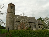
es in Norfolk
. The church was almost entirely refurbished in the 19th century but still possess its medieval font and screen. The church is a Grade I listed building http://www.imagesofengland.org.uk/details/default.aspx?id=225076.
was installed by Lord Justice Kay
in 1867 and has a wooden canopy placed over it. The pump has undergone several restorations - in 1924 by a local doctor and, more recently, by the villagers in 1979.
Civil parish
In England, a civil parish is a territorial designation and, where they are found, the lowest tier of local government below districts and counties...
of Brockdish
Brockdish
Brockdish is a village and civil parish in the South Norfolk district of Norfolk, England. It is in size. According to the 2001 census the parish had a population of 605 in 265 households. The village is situated on the River Waveney , and is about three miles south-west of Harleston...
in the English
England
England is a country that is part of the United Kingdom. It shares land borders with Scotland to the north and Wales to the west; the Irish Sea is to the north west, the Celtic Sea to the south west, with the North Sea to the east and the English Channel to the south separating it from continental...
county of Norfolk
Norfolk
Norfolk is a low-lying county in the East of England. It has borders with Lincolnshire to the west, Cambridgeshire to the west and southwest and Suffolk to the south. Its northern and eastern boundaries are the North Sea coast and to the north-west the county is bordered by The Wash. The county...
. The village is 6.5 miles (10.5 km) east of Diss
Diss
Diss is a town in Norfolk, England close to the border with the neighbouring East Anglian county of Suffolk.The town lies in the valley of the River Waveney, around a mere that covers . The mere is up to deep, although there is another of mud, making it one of the deepest natural inland lakes...
, 20.8 miles (33.5 km) south south west of Norwich
Norwich
Norwich is a city in England. It is the regional administrative centre and county town of Norfolk. During the 11th century, Norwich was the largest city in England after London, and one of the most important places in the kingdom...
and 106 miles (170.6 km) north east of London
London
London is the capital city of :England and the :United Kingdom, the largest metropolitan area in the United Kingdom, and the largest urban zone in the European Union by most measures. Located on the River Thames, London has been a major settlement for two millennia, its history going back to its...
. The village lies 0.4 mile (0.643736 km) north of the of A143
A143 road
The A143 is a road that runs from Great Yarmouth in Norfolk to Haverhill in Suffolk.For much of the route the road is classified as a primary route. Over the years the road has been much improved with new by-passes opening at regular intervals...
Diss to Great Yarmouth
Great Yarmouth
Great Yarmouth, often known to locals as Yarmouth, is a coastal town in Norfolk, England. It is at the mouth of the River Yare, east of Norwich.It has been a seaside resort since 1760, and is the gateway from the Norfolk Broads to the sea...
road. The nearest railway station is at Diss
Diss railway station
Diss is a railway station which serves the town of Diss in Norfolk, England. The station is on the Great Eastern Main Line south of Norwich towards London Liverpool Street. The station, and all trains serving it, are operated by National Express East Anglia...
for the Great Eastern Main Line
Great Eastern Main Line
The Great Eastern Main Line is a 212 Kilometre major railway line of the British railway system, which connects Liverpool Street in the City of London with destinations in east London and the East of England, including Chelmsford, Colchester, Ipswich, Norwich and several coastal resorts such as...
which runs between Norwich
Norwich
Norwich is a city in England. It is the regional administrative centre and county town of Norfolk. During the 11th century, Norwich was the largest city in England after London, and one of the most important places in the kingdom...
and Liverpool Street station, London
Liverpool Street station
Liverpool Street railway station, also known as London Liverpool Street or simply Liverpool Street, is both a central London railway terminus and a connected London Underground station in the north-eastern corner of the City of London, England...
. The nearest airport is Norwich International Airport
Norwich International Airport
Norwich International Airport , also known as Norwich Airport, is an airport in the City of Norwich within Norfolk, England north of the city centre and on the edge of the city's suburbs....
. The village, as part of the larger parish in the 2001 census
United Kingdom Census 2001
A nationwide census, known as Census 2001, was conducted in the United Kingdom on Sunday, 29 April 2001. This was the 20th UK Census and recorded a resident population of 58,789,194....
, had a population of 605. For the purposes of local government, the parish falls within the district
Non-metropolitan district
Non-metropolitan districts, or colloquially shire districts, are a type of local government district in England. As created, they are sub-divisions of non-metropolitan counties in a so-called "two-tier" arrangement...
of South Norfolk
South Norfolk
South Norfolk is a local government district in Norfolk, England. Its council is based in Long Stratton.-History:The district was formed on April 1, 1974, under the Local Government Act 1972, as a merger of Diss Urban District, Wymondham Urban District, Depwade Rural District, Forehoe and Henstead...
.
History
Thorpe Abbotts has an entry in the Domesday BookDomesday Book
Domesday Book , now held at The National Archives, Kew, Richmond upon Thames in South West London, is the record of the great survey of much of England and parts of Wales completed in 1086...
of 1085. In the great book Thorpe Abbotts is recorded by the name Thorp and is said to be King’s land, in the charge of William de Noyers
Norreys
Norreys may refer to various members of, or estates belonging to, a landed family chiefly seated in the English counties of Berkshire and Lancashire and the Irish county of Cork....
.
Station 139
During the second world war Thorpe AbbottsRAF Thorpe Abbotts
RAF Thorpe Abbotts is a former World War II airfield in England. The field is located 4 miles E of Diss in Norfolk.-Overview:Thorpe Abbotts airfield was built during 1942 and early 1943 for the RAF as a satellite airfield for RAF Horham but the rapid buildup of the 8th Air Force resulted in both...
became home to an airbase with the designation 139, Thorpe Abbotts. The airbase was built in 1942 by John Laing & Sons Ltd. The base had three intersecting runways laid with concrete
Concrete
Concrete is a composite construction material, composed of cement and other cementitious materials such as fly ash and slag cement, aggregate , water and chemical admixtures.The word concrete comes from the Latin word...
which were encircled by a three and a half mile perimeter road. The perimeter road had hard standings for fifty aircraft. There were two hangars, a technical site and a domestic area. The base became operational in June 1943 when the 100th Bomb Group of the United States Army Air Force took up residency. The group became known as the ‘’Bloody 100th’’ because of the heavy losses incurred by the group on a number of their combat missions. The 100th were the only group to fly operations from Thorpe Abbots and during a period between June the 15th 1943 and April 10, 1945, 306 missions were flown from the base. The 100th group flew B-17 Flying Fortress from Thorpe Abbotts. The USAAF left the base in December 1945 when the base was transferred to the RAF and it remained inactive until April 1956 when the base was finally de-requisitioned. The land owned by Sir Rupert Mann has been returned to agricultural use but the perimeter road remained intact until 1986 when it was demolished. Some of the buildings including the control tower still survive. Today the old control tower has been fully restored and contains a museum dedicated to the famous 'Bloody Hundredth' BombGroup. The museum tells the story of Thorpe Abbotts and portrays every-day life on an American bomber base. A D-4 link trainer is on display, while a B-24 tail turret is undergoing restoration. Special events and reunions are frequently staged.
Eddie the Ghost
From time to time visitors to the museum report an overpowering presence within the control tower occasionally accompanied by the brief glimpse of an airman dressed in full flying gear. The sound of VHF chatter and the sound of aircraft have also been heard. These strange apparitions are not a new phenomena. Eddie the Ghost as American personnel nicknamed him, began to appear after the first Berlin raids in 1942; he was reported as walking through walls of the airman’s quarters. Stories of the ghost persisted with some of the men taking their carbines to bed with them. Fearing an accident, Colonel Jeffrey, the base commander, forbade all talk of Eddie on penalty of court martial. Today sightings are less frequently recorded although Eddie is occasionally seen when the tower is locked at night. He appears at the first floor window looking out as if to say good night.All Saints parish church
All Saints parish church is one of 124 existing round-tower churchRound-tower church
Round-tower churches are a type of church found mainly in England, almost solely in East Anglia; of about 185 surviving examples in the country, 124 are in Norfolk, 38 in Suffolk, 6 in Essex, 3 in Sussex and 2 each in Cambridgeshire and Berkshire. There is evidence of about twenty round-tower...
es in Norfolk
Norfolk
Norfolk is a low-lying county in the East of England. It has borders with Lincolnshire to the west, Cambridgeshire to the west and southwest and Suffolk to the south. Its northern and eastern boundaries are the North Sea coast and to the north-west the county is bordered by The Wash. The county...
. The church was almost entirely refurbished in the 19th century but still possess its medieval font and screen. The church is a Grade I listed building http://www.imagesofengland.org.uk/details/default.aspx?id=225076.
The village pump
The village hand pumpHand pump
Hand pumps are manually operated pumps; they use human power and mechanical advantage to move fluids or air from one place to another. They are widely used in every country in the world for a variety of industrial, marine, irrigation and leisure activities...
was installed by Lord Justice Kay
Edward Ebenezer Kay
Sir Edward Ebenezer Kay was a British jurist. He was an English High Court judge from 1881 to 1890, and a Lord Justice of Appeal from 1890, when he was made a Privy Councillor, until his retirement in January 1897.He was born in Meadowcroft near Rochdale and grew up in Bury and was the...
in 1867 and has a wooden canopy placed over it. The pump has undergone several restorations - in 1924 by a local doctor and, more recently, by the villagers in 1979.
External links
- Church and village website
- Diss Express - village's local newspaper website
- Website with photos of Thorpe Abbotts All Saints, a round-tower churchRound-tower churchRound-tower churches are a type of church found mainly in England, almost solely in East Anglia; of about 185 surviving examples in the country, 124 are in Norfolk, 38 in Suffolk, 6 in Essex, 3 in Sussex and 2 each in Cambridgeshire and Berkshire. There is evidence of about twenty round-tower...
- 100th Bomb Group website
- Thorpe Abbots photo gallery