
Thomas Brunner
Encyclopedia
.jpg)
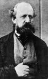
Thomas Brunner (baptised 22 August 1821, in Oxford
Oxford
The city of Oxford is the county town of Oxfordshire, England. The city, made prominent by its medieval university, has a population of just under 165,000, with 153,900 living within the district boundary. It lies about 50 miles north-west of London. The rivers Cherwell and Thames run through...
, England
England
England is a country that is part of the United Kingdom. It shares land borders with Scotland to the north and Wales to the west; the Irish Sea is to the north west, the Celtic Sea to the south west, with the North Sea to the east and the English Channel to the south separating it from continental...
; died 22 April 1874 in Nelson, New Zealand
Nelson, New Zealand
Nelson is a city on the eastern shores of Tasman Bay, and is the economic and cultural centre of the Nelson-Tasman region. Established in 1841, it is the second oldest settled city in New Zealand and the oldest in the South Island....
) was an English
England
England is a country that is part of the United Kingdom. It shares land borders with Scotland to the north and Wales to the west; the Irish Sea is to the north west, the Celtic Sea to the south west, with the North Sea to the east and the English Channel to the south separating it from continental...
-born surveyor
Surveying
See Also: Public Land Survey SystemSurveying or land surveying is the technique, profession, and science of accurately determining the terrestrial or three-dimensional position of points and the distances and angles between them...
and explorer remembered for his exploration of the western coastal areas of New Zealand
New Zealand
New Zealand is an island country in the south-western Pacific Ocean comprising two main landmasses and numerous smaller islands. The country is situated some east of Australia across the Tasman Sea, and roughly south of the Pacific island nations of New Caledonia, Fiji, and Tonga...
's South Island
South Island
The South Island is the larger of the two major islands of New Zealand, the other being the more populous North Island. It is bordered to the north by Cook Strait, to the west by the Tasman Sea, to the south and east by the Pacific Ocean...
.
In 1836, aged fifteen, Brunner was sent to learn surveying from an Oxford architect and surveyor, Thomas Greenshields. Five years later, in 1841, he was appointed by the New Zealand Company
New Zealand Company
The New Zealand Company originated in London in 1837 as the New Zealand Association with the aim of promoting the "systematic" colonisation of New Zealand. The association, and later the company, intended to follow the colonising principles of Edward Gibbon Wakefield, who envisaged the creation of...
as an apprentice surveyor and joined a party of colonists travelling to establish a settlement at Nelson, New Zealand
Nelson, New Zealand
Nelson is a city on the eastern shores of Tasman Bay, and is the economic and cultural centre of the Nelson-Tasman region. Established in 1841, it is the second oldest settled city in New Zealand and the oldest in the South Island....
. They arrived at Port Nicholson
Wellington Harbour
Wellington Harbour is the large natural harbour at the southern tip of New Zealand's North Island. New Zealand's capital, Wellington, is on the western side of Wellington Harbour. The harbour was officially named Port Nicholson until it assumed its current name in the 1980s.In Māori the harbour is...
, New Zealand, on 9 September and then crossed the Cook Strait
Cook Strait
Cook Strait is the strait between the North and South Islands of New Zealand. It connects the Tasman Sea on the west with the South Pacific Ocean on the east....
to the new site, arriving on 4 November.
For two years thereafter, Brunner assisted in the laying out of the new settlement. During that time, the colony began to appropriate more and more of the nearby Wairau plain, but after the Wairau Affray
Wairau Affray
In New Zealand history, the Wairau Affray on 17 June 1843 was the first serious clash of arms between Māori and the British settlers after the signing of the Treaty of Waitangi, and the only one to take place in the South Island...
in 1843, the settlement was forced to look south for more farming land. Brunner, working with Kehu, a Māori he had befriended, was one of those exploring the area. In February 1846, he, Kehu, Charles Heaphy
Charles Heaphy
Major Charles Heaphy VC was a New Zealand explorer and a recipient of the Victoria Cross, the highest and most prestigious military award for gallantry in the face of the enemy that can be awarded to British and Commonwealth forces....
and William Fox
William Fox (New Zealand)
Sir William Fox, KCMG was the second Premier of New Zealand on four occasions in the 19th century, while New Zealand was still a colony. He was known for his eventual support of Māori land rights, his contributions to the education system , and his work to increase New Zealand's autonomy from...
explored the upper reaches of the Buller River
Buller River
The Buller River is in the South Island of New Zealand. One of the country's longest rivers, it flows for 170 kilometres from Lake Rotoiti through the Buller Gorge and into the Tasman Sea near the town of Westport...
as far as the Maruia River
Maruia River
The Maruia River is located in the northwestern South Island of New Zealand. It is a major tributary of the Buller River, flowing for 80 kilometres before joining the larger river eight kilometres to the west of Murchison....
, before dwindling provisions forced their return. Three weeks later, the party, less Fox, left Nelson on a five-month expedition tracing the western coast
West Coast, New Zealand
The West Coast is one of the administrative regions of New Zealand, located on the west coast of the South Island, and is one of the more remote and most sparsely populated areas of the country. It is made up of three districts: Buller, Grey and Westland...
of South Island as far south as Hokitika
Hokitika, New Zealand
Hokitika is a township in the West Coast Region of New Zealand's South Island, south of Greymouth, and close to the mouth of the Hokitika River. According to the 2006 census, the usually resident population of the Hokitika urban area was 3,078, a decrease of 12 people since 2001. A further 828...
. During this time, Brunner and Heaphy became the first Europeans to visit the Poutini Ngāi Tahu
Ngāi Tahu
Ngāi Tahu, or Kāi Tahu, is the principal Māori iwi of the southern region of New Zealand, with the tribal authority, Te Rūnanga o Ngāi Tahu, being based in Christchurch and Invercargill. The iwi combines three groups, Kāi Tahu itself, and Waitaha and Kāti Mamoe who lived in the South Island prior...
settlements at Taramakau, Arahura and Mawhera (now Greymouth). They also identified Aoraki/Mount Cook
Aoraki/Mount Cook
Aoraki / Mount Cook is the highest mountain in New Zealand, reaching .It lies in the Southern Alps, the mountain range which runs the length of the South Island. A popular tourist destination, it is also a favourite challenge for mountain climbers...
as New Zealand's highest mountain.
In December 1846, Brunner began what became his longest and most arduous expedition, following the Buller River to the sea and the west coast as far south as Milford Sound
Milford Sound
Milford Sound is a fjord in the south west of New Zealand's South Island, within Fiordland National Park, Piopiotahi Marine Reserve, and the Te Wahipounamu World Heritage site...
. He and his party also searched for a pass across the Southern Alps
Southern Alps
The Southern Alps is a mountain range extending along much of the length of New Zealand's South Island, reaching its greatest elevations near the island's western side...
. By the end of the following year, they had returned to Mawhera and in early 1848 began the journey back to Nelson, via the Grey and Inangahua
Inangahua River
The Inangahua River is located in the northwest of New Zealand’s South Island. It is a major tributary of the Buller River, which it joins at the town of Inangahua Junction....
river valleys. Also during this time, Brunner and his party ran out of provisions and so were forced to kill and eat their dog. While in Buller Gorge
Buller Gorge
The Buller Gorge is a gorge located in the northwest of the South Island of New Zealand. The Buller River flows through the deep canyon between Murchison and Westport. Land Information New Zealand lists two sections for the gorge, Upper Buller Gorge and Lower Buller Gorge. State Highway 6 runs...
, Brunner apparently suffered a stroke, leaving him paralysed on one side of his body. However, with the aid of Kehu and the rest of his party, he was able to reach Nelson in June 1848. As well as further information about the west coast, Brunner informed the colony that coal was to be found in the Grey River valley.
When news of Brunner's exploits reached England, the Royal Geographical Society
Royal Geographical Society
The Royal Geographical Society is a British learned society founded in 1830 for the advancement of geographical sciences...
awarded him their Patron's Medal in 1851. Brunner's ill-health, however, prevented him from undertaking any further expeditions, although he later returned south along the west coast to lay out the settlements that would become Greymouth and Westport
Westport, New Zealand
-Economy:Economic activity is based around fishing, coal mining and dairy farming. Historically, gold mining was a major industry, and coal mining was much more extensive than today . However, the region still is home to New Zealand's largest opencast mining operation in Stockton...
. He retired in 1869 and died on 22 April 1874, in Nelson. A large Māori party attended his funeral at Nelson Cathedral, including his long-time friend Kehu.
See also
- BrunnerBrunner, New ZealandBrunner is a town in the northwest of New Zealand's South Island. Together with Taylorville and Dobson to the south-west, it had a population of 672 at the 2006 census. It is 12 kilometres to the east of Greymouth, on the south bank of the Grey River. It is on the Midland Line railway near its...
and Lake BrunnerLake BrunnerLake Brunner is the largest lake in the northwestern South Island of New Zealand, covering an area of 40 km². The lake's outflow is the Arnold River, a tributary of the Grey River. The lake lies 31 kilometres to the southeast of Greymouth...
, a town and a lake in the South Island named in Brunner's memory.