

The Fylde
Encyclopedia
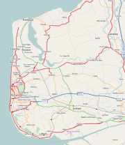
Plain
In geography, a plain is land with relatively low relief, that is flat or gently rolling. Prairies and steppes are types of plains, and the archetype for a plain is often thought of as a grassland, but plains in their natural state may also be covered in shrublands, woodland and forest, or...
in western Lancashire
Lancashire
Lancashire is a non-metropolitan county of historic origin in the North West of England. It takes its name from the city of Lancaster, and is sometimes known as the County of Lancaster. Although Lancaster is still considered to be the county town, Lancashire County Council is based in Preston...
, England
England
England is a country that is part of the United Kingdom. It shares land borders with Scotland to the north and Wales to the west; the Irish Sea is to the north west, the Celtic Sea to the south west, with the North Sea to the east and the English Channel to the south separating it from continental...
. It is roughly a 13-mile (20-kilometre) square
Square (geometry)
In geometry, a square is a regular quadrilateral. This means that it has four equal sides and four equal angles...
-shaped peninsula
Peninsula
A peninsula is a piece of land that is bordered by water on three sides but connected to mainland. In many Germanic and Celtic languages and also in Baltic, Slavic and Hungarian, peninsulas are called "half-islands"....
, bounded by Morecambe Bay
Morecambe Bay
Morecambe Bay is a large bay in northwest England, nearly due east of the Isle of Man and just to the south of the Lake District National Park. It is the largest expanse of intertidal mudflats and sand in the United Kingdom, covering a total area of 310 km².-Natural features:The rivers Leven,...
to the north, the Ribble
River Ribble
The River Ribble is a river that runs through North Yorkshire and Lancashire, in northern England. The river's drainage basin also includes parts of Greater Manchester around Wigan.-Geography:...
estuary to the south, the Irish Sea
Irish Sea
The Irish Sea separates the islands of Ireland and Great Britain. It is connected to the Celtic Sea in the south by St George's Channel, and to the Atlantic Ocean in the north by the North Channel. Anglesey is the largest island within the Irish Sea, followed by the Isle of Man...
to the west, and the Bowland
Forest of Bowland
The Forest of Bowland, also known as the Bowland Fells, is an area of barren gritstone fells, deep valleys and peat moorland, mostly in north-east Lancashire, England. A small part lies in North Yorkshire, and much of the area was historically part of the West Riding of Yorkshire...
hills to the east. The eastern boundary is approximately the location of the M6 motorway
M6 motorway
The M6 motorway runs from junction 19 of the M1 at the Catthorpe Interchange, near Rugby via Birmingham then heads north, passing Stoke-on-Trent, Manchester, Preston, Carlisle and terminating at the Gretna junction . Here, just short of the Scottish border it becomes the A74 which continues to...
.
It is a flat, alluvial plain
Alluvial plain
An alluvial plain is a relatively flat landform created by the deposition of sediment over a long period of time by one or more rivers coming from highland regions, from which alluvial soil forms...
; parts were once dug for peat
Peat
Peat is an accumulation of partially decayed vegetation matter or histosol. Peat forms in wetland bogs, moors, muskegs, pocosins, mires, and peat swamp forests. Peat is harvested as an important source of fuel in certain parts of the world...
, and it is the western part of an area formerly known as Amounderness
Amounderness
Amounderness was a hundred of Lancashire in North West England. Formerly, the name had been used for territories now in Lancashire and north of the River Ribble that had been included in Domesday Yorkshire.-Etymology and history:...
.
The west coast is almost entirely urban, containing the towns of Fleetwood
Fleetwood
Fleetwood is a town within the Wyre district of Lancashire, England, lying at the northwest corner of the Fylde. It had a population of 26,840 people at the 2001 Census. It forms part of the Greater Blackpool conurbation. The town was the first planned community of the Victorian era...
, Cleveleys
Cleveleys
Cleveleys is a town on the Fylde Coast of Lancashire, England, about 4 miles north of Blackpool and 2 miles south of Fleetwood...
, Blackpool
Blackpool
Blackpool is a borough, seaside town, and unitary authority area of Lancashire, in North West England. It is situated along England's west coast by the Irish Sea, between the Ribble and Wyre estuaries, northwest of Preston, north of Liverpool, and northwest of Manchester...
and Lytham St Annes
Lytham St Annes
Lytham St Annes is a conurbation in the Fylde district of Lancashire, England. The neighbouring towns of Lytham and St-Anne's-on-the-Sea have grown together and now form a seaside resort...
, with Thornton
Thornton, Lancashire
Thornton is a village on the Fylde, in Lancashire, England, about four miles north of Blackpool and two miles south of Fleetwood. It is in the Borough of Wyre...
, Carleton
Carleton, Lancashire
Carleton is a village on the coastal plain of the Fylde in Lancashire, England. It consists of Great Carleton, Little Carleton and Norcross and is situated close to the market town of Poulton-le-Fylde. Nearby settlements include Thornton, Bispham and Blackpool...
and Poulton-le-Fylde
Poulton-le-Fylde
Poulton-le-Fylde is a market town in Lancashire, England, situated on the coastal plain called the Fylde. As of the 2001 United Kingdom census, it had a population of 18,264. There is evidence of human habitation in the area from 12,000 years ago and several archaeological finds from Roman...
not far inland. This area forms the Blackpool Urban Area
Blackpool Urban Area
Greater Blackpool is the informal name for the urban area surrounding Blackpool in Lancashire, England. The ONS define a Blackpool Urban Area, with a population of 261,088 , down 0.1% from the 1991 figure of 261,355....
. The central southern part of the Fylde includes the smaller towns of Kirkham
Kirkham, Lancashire
Kirkham, or as it once was known, Kirkam-in-Amounderness is a town and civil parish in the Borough of Fylde in Lancashire, England, midway between Blackpool and Preston and adjacent to the smaller town of Wesham. It owes its existence to Carr Hill upon which it was built and which was the location...
and Wesham
Wesham
Medlar with Wesham is civil parish on the Fylde in Lancashire, England. It lies within the Borough of Fylde, and had a population of 3,245 in 1,294 households recorded in the 2001 census....
. The rest of the Fylde is rural, containing villages that include Freckleton
Freckleton
Freckleton is a village and civil parish on the Fylde coast in Lancashire, England, to the south of Kirkham and east of the seaside resort of Lytham St. Annes. It has a population of 6,045.Freckleton is near to Warton, with its links to BAE Systems...
, Warton
Warton, Fylde
Warton is a village on the Fylde in Lancashire, England.The village is about six miles from Preston and eight miles from Blackpool. It is located on the banks of the River Ribble, close to its entry into the Irish Sea. It is best known for its airfield, BAE Warton and its associated aircraft works...
, Wrea Green
Wrea Green
Wrea Green is a village in the Fylde borough of Lancashire, England. It lies about 2 miles west of Kirkham. Along with the village of Ribby, it forms the civil parish Ribby with Wrea....
, Great Eccleston
Great Eccleston
Great Eccleston is a village and civil parish in the English county of Lancashire, situated on a coastal plain called the Fylde. The village lies to the south of the River Wyre and the A586 road, approximately upstream from the port of Fleetwood...
, Hambleton
Hambleton, Lancashire
Hambleton is a village and civil parish in the English county of Lancashire. It is situated on a coastal plain called the Fylde and in an area east of the River Wyre known locally as Over Wyre. Hambleton lies approximately north-east of its post town, Poulton-le-Fylde, and about north-east of the...
, Knott End and Pilling
Pilling
Pilling is a village and civil parish within the Wyre borough of Lancashire, England. It is north-northeast of Poulton-le-Fylde, south-southwest of Lancaster and northwest of Preston, in a part of the Fylde known as Over Wyre....
.
The River Wyre
River Wyre
The River Wyre is a river in Lancashire, United Kingdom, which flows into the Irish Sea at Fleetwood. It is approximately 28 miles in length...
meanders across the Fylde from Garstang
Garstang
Garstang is a town and civil parish within the Wyre borough of Lancashire, England. It is ten miles north-northwest of the city of Preston and eleven miles south of Lancaster, and had a total resident population of 4,074 in 2001....
on the eastern edge, westwards towards Poulton
Poulton-le-Fylde
Poulton-le-Fylde is a market town in Lancashire, England, situated on the coastal plain called the Fylde. As of the 2001 United Kingdom census, it had a population of 18,264. There is evidence of human habitation in the area from 12,000 years ago and several archaeological finds from Roman...
and then northwards to the sea at Fleetwood
Fleetwood
Fleetwood is a town within the Wyre district of Lancashire, England, lying at the northwest corner of the Fylde. It had a population of 26,840 people at the 2001 Census. It forms part of the Greater Blackpool conurbation. The town was the first planned community of the Victorian era...
. The area north and east of the tidal Wyre, known as Over Wyre
Over Wyre
Over Wyre is the collective name given to a group of villages in Lancashire, England, situated on the Fylde, to the north of the River Wyre. The group is usually considered to include Hambleton, Stalmine, Knott End-on-Sea, Preesall, Pilling and Out Rawcliffe...
, is the more rural side of the river. The Fylde is roughly trisected by the M55 motorway
M55 motorway
The M55 is a motorway in Lancashire, England, which can also be referred to as the Preston Northern Bypass. It connects the seaside resort of Blackpool to the M6 at Preston. It is 11.4 miles in length.-Route:...
and A586 road.
The Borough of Fylde is a local government area covering the south of the Fylde plain. The rest is covered by the boroughs of Wyre and Blackpool
Blackpool
Blackpool is a borough, seaside town, and unitary authority area of Lancashire, in North West England. It is situated along England's west coast by the Irish Sea, between the Ribble and Wyre estuaries, northwest of Preston, north of Liverpool, and northwest of Manchester...
to the north and west respectively. The local justice area covering all of the Fylde is called Fylde Coast.