
River Wyre
Encyclopedia
The River Wyre is a river
in Lancashire
, United Kingdom
, which flows into the Irish Sea
at Fleetwood
. It is approximately 28 miles (45 km) in length. The river is a County Biological Heritage Site.
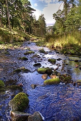
 The river rises in the Forest of Bowland
in central Lancashire, as two distinct tributaries, the Tarnbrook Wyre and the Marshaw Wyre, whose confluence
is near the village of Abbeystead
. A pumping station was built just below the confluence as part of a water transfer scheme in the 1980s. During a site visit by villagers from nearby St Michael's On Wyre
in 1984, a major explosion
caused by a buildup of naturally occurring methane
gas occurred. 16 people were killed and a further 22 were injured.
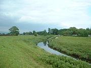
From Abbeystead, the river flows south through Dolphinholme
and Garstang
to Catterall
where it meets its first major tributary, the River Calder
. The river then turns westwards, flowing through St Michael's On Wyre
where it is joined by its second major tributary, the River Brock
. It becomes tidal below the weir at St Michael's.
It is crossed by a toll bridge
(normal fee is 40 pence
) at Cartford, between Little Eccleston
and Out Rawcliffe
. A former toll bridge, Shard Bridge
, close to Poulton-le-Fylde
, has been rebuilt and is now free. The Lancaster Canal
crosses on a small aqueduct
at Garstang
. A pedestrian ferry runs between Fleetwood
and Knott End but the ferry to the Isle of Man
no longer runs.
Major industry existed at the former ICI
site at Burn Naze, close to the estuary of the river. It was originally an alkali
works taking brine
from mines and wells
across the river in and around Preesall
. Later processes undertaken on the site included those dealing with Vinyl Chloride Monomer, although this was later moved to Runcorn
and ICI activity on the site ceased. Industrial activity by a number of various companies continues by the river, albeit on a much reduced scale.
The area around Burn Naze on the western side of the Wyre Estuary was formerly known as Bergerode, believed to be an Old English term for "shallow harbour", beor grade.
Fleetwood
at the mouth of the river was a major fishing port up until the latter part of the 20th century. Wyre Dock was built there between 1869 and 1877. With the decline in the size of the fleet, most of the dock complex has subsequently been converted to a marina
and the adjacent "Freeport" shopping village.
The river drains a total catchment area of approximately 175 square miles (450 km²). The tidal portion of the river below Cartford Bridge drains a catchment area of approximately 125 square miles (320 km²).
The Wyre is reputedly the longest river in England whose estuary can be seen from its source.
River
A river is a natural watercourse, usually freshwater, flowing towards an ocean, a lake, a sea, or another river. In a few cases, a river simply flows into the ground or dries up completely before reaching another body of water. Small rivers may also be called by several other names, including...
in Lancashire
Lancashire
Lancashire is a non-metropolitan county of historic origin in the North West of England. It takes its name from the city of Lancaster, and is sometimes known as the County of Lancaster. Although Lancaster is still considered to be the county town, Lancashire County Council is based in Preston...
, United Kingdom
United Kingdom
The United Kingdom of Great Britain and Northern IrelandIn the United Kingdom and Dependencies, other languages have been officially recognised as legitimate autochthonous languages under the European Charter for Regional or Minority Languages...
, which flows into the Irish Sea
Irish Sea
The Irish Sea separates the islands of Ireland and Great Britain. It is connected to the Celtic Sea in the south by St George's Channel, and to the Atlantic Ocean in the north by the North Channel. Anglesey is the largest island within the Irish Sea, followed by the Isle of Man...
at Fleetwood
Fleetwood
Fleetwood is a town within the Wyre district of Lancashire, England, lying at the northwest corner of the Fylde. It had a population of 26,840 people at the 2001 Census. It forms part of the Greater Blackpool conurbation. The town was the first planned community of the Victorian era...
. It is approximately 28 miles (45 km) in length. The river is a County Biological Heritage Site.
Geography
Forest of Bowland
The Forest of Bowland, also known as the Bowland Fells, is an area of barren gritstone fells, deep valleys and peat moorland, mostly in north-east Lancashire, England. A small part lies in North Yorkshire, and much of the area was historically part of the West Riding of Yorkshire...
in central Lancashire, as two distinct tributaries, the Tarnbrook Wyre and the Marshaw Wyre, whose confluence
Confluence
Confluence, in geography, describes the meeting of two or more bodies of water.Confluence may also refer to:* Confluence , a property of term rewriting systems...
is near the village of Abbeystead
Abbeystead
Abbeystead is a small, picturesque village located in the Forest of Bowland Area of Outstanding Natural Beauty, in Lancashire, England. Abbeystead lies close to the Trough of Bowland but even in medieval times, was considered part of Wyresdale rather than within the domain of that powerful local...
. A pumping station was built just below the confluence as part of a water transfer scheme in the 1980s. During a site visit by villagers from nearby St Michael's On Wyre
St Michael's On Wyre
St Michael's on Wyre is a village on the Fylde, in the Borough of Wyre, in Lancashire, England; it lies on the River Wyre. The village is centred on the church of St Michael's which was founded before AD 640...
in 1984, a major explosion
Abbeystead disaster
The Abbeystead disaster occurred on the evening of 23 May 1984 when a methane gas explosion destroyed a waterworks' valve house at Abbeystead, Lancashire, England. A group of 44 visitors were inside the underground building at the time attending a public presentation by North West Water Authority ...
caused by a buildup of naturally occurring methane
Methane
Methane is a chemical compound with the chemical formula . It is the simplest alkane, the principal component of natural gas, and probably the most abundant organic compound on earth. The relative abundance of methane makes it an attractive fuel...
gas occurred. 16 people were killed and a further 22 were injured.
From Abbeystead, the river flows south through Dolphinholme
Dolphinholme
-History:In the 18th and 19th centuries the village played an important part in the industrial revolution. Slave trader Thomas Hinde founded a mill in Lower Dolphinholme in 1795....
and Garstang
Garstang
Garstang is a town and civil parish within the Wyre borough of Lancashire, England. It is ten miles north-northwest of the city of Preston and eleven miles south of Lancaster, and had a total resident population of 4,074 in 2001....
to Catterall
Catterall
Catterall is a civil parish in the county of Lancashire in the north of England, located within the Borough of Wyre. Historically in the Amounderness Hundred, it is situated on the A6 between Lancaster and Preston, a short distance from the town of Garstang, and Myerscough College. The Wyre, Calder...
where it meets its first major tributary, the River Calder
River Calder, Wyre
The River Calder is the main tributary of the River Wyre in Lancashire, England. It rises near Fiendsdale Head in the Forest of Bowland and flows through the villages of Oakenclough and Calder Vale before passing under the M6 motorway, West Coast Main Line and Lancaster Canal...
. The river then turns westwards, flowing through St Michael's On Wyre
St Michael's On Wyre
St Michael's on Wyre is a village on the Fylde, in the Borough of Wyre, in Lancashire, England; it lies on the River Wyre. The village is centred on the church of St Michael's which was founded before AD 640...
where it is joined by its second major tributary, the River Brock
River Brock
The River Brock is a river running through the county of Lancashire in England.Commencing its journey on Fair Snape Fell, the infant River Brock runs beneath the Bleasdale Circle before continuing via Claughton and Bilsborrow to St Michael's On Wyre, where it joins the River Wyre.-Tributaries:*New...
. It becomes tidal below the weir at St Michael's.
It is crossed by a toll bridge
Toll bridge
A toll bridge is a bridge over which traffic may pass upon payment of a toll, or fee.- History :The practice of collecting tolls on bridges probably harks back to the days of ferry crossings where people paid a fee to be ferried across stretches of water. As boats became impractical to carry large...
(normal fee is 40 pence
Penny
A penny is a coin or a type of currency used in several English-speaking countries. It is often the smallest denomination within a currency system.-Etymology:...
) at Cartford, between Little Eccleston
Little Eccleston
Little Eccleston with Larbreck is a civil parish on the southern bank of the River Wyre on the Fylde in the English county of Lancashire. The river is crossed by Cartford Bridge, a toll bridge, an unusual feature in England....
and Out Rawcliffe
Out Rawcliffe
Out Rawcliffe is a village and civil parish on the north bank of the River Wyre in the Over Wyre area of the Fylde in Lancashire, England.It is the location of the medieval Rawcliffe Hall...
. A former toll bridge, Shard Bridge
Shard Bridge
Shard Bridge is a bridge in the English county of Lancashire. It spans the River Wyre, connecting Singleton, on the southern side of the river, to Hambleton, on its northern side , carrying both automotive and pedestrian traffic of Shard Road .The original bridge was built in 1864, and it went on...
, close to Poulton-le-Fylde
Poulton-le-Fylde
Poulton-le-Fylde is a market town in Lancashire, England, situated on the coastal plain called the Fylde. As of the 2001 United Kingdom census, it had a population of 18,264. There is evidence of human habitation in the area from 12,000 years ago and several archaeological finds from Roman...
, has been rebuilt and is now free. The Lancaster Canal
Lancaster Canal
The Lancaster Canal is a canal in the north of England, originally planned to run from Westhoughton in Lancashire to Kendal in south Cumbria...
crosses on a small aqueduct
Aqueduct
An aqueduct is a water supply or navigable channel constructed to convey water. In modern engineering, the term is used for any system of pipes, ditches, canals, tunnels, and other structures used for this purpose....
at Garstang
Garstang
Garstang is a town and civil parish within the Wyre borough of Lancashire, England. It is ten miles north-northwest of the city of Preston and eleven miles south of Lancaster, and had a total resident population of 4,074 in 2001....
. A pedestrian ferry runs between Fleetwood
Fleetwood
Fleetwood is a town within the Wyre district of Lancashire, England, lying at the northwest corner of the Fylde. It had a population of 26,840 people at the 2001 Census. It forms part of the Greater Blackpool conurbation. The town was the first planned community of the Victorian era...
and Knott End but the ferry to the Isle of Man
Isle of Man
The Isle of Man , otherwise known simply as Mann , is a self-governing British Crown Dependency, located in the Irish Sea between the islands of Great Britain and Ireland, within the British Isles. The head of state is Queen Elizabeth II, who holds the title of Lord of Mann. The Lord of Mann is...
no longer runs.
Major industry existed at the former ICI
Imperial Chemical Industries
Imperial Chemical Industries was a British chemical company, taken over by AkzoNobel, a Dutch conglomerate, one of the largest chemical producers in the world. In its heyday, ICI was the largest manufacturing company in the British Empire, and commonly regarded as a "bellwether of the British...
site at Burn Naze, close to the estuary of the river. It was originally an alkali
Alkali
In chemistry, an alkali is a basic, ionic salt of an alkali metal or alkaline earth metal element. Some authors also define an alkali as a base that dissolves in water. A solution of a soluble base has a pH greater than 7. The adjective alkaline is commonly used in English as a synonym for base,...
works taking brine
Brine
Brine is water, saturated or nearly saturated with salt .Brine is used to preserve vegetables, fruit, fish, and meat, in a process known as brining . Brine is also commonly used to age Halloumi and Feta cheeses, or for pickling foodstuffs, as a means of preserving them...
from mines and wells
Wells
Wells is a cathedral city and civil parish in the Mendip district of Somerset, England, on the southern edge of the Mendip Hills. Although the population recorded in the 2001 census is 10,406, it has had city status since 1205...
across the river in and around Preesall
Preesall
Preesall is a town and civil parish in Lancashire, England. The parish covers the eastern bank of the estuary of the River Wyre, including Knott End-on-Sea, Pilling Lane and the village of Preesall itself...
. Later processes undertaken on the site included those dealing with Vinyl Chloride Monomer, although this was later moved to Runcorn
Runcorn
Runcorn is an industrial town and cargo port within the borough of Halton in the ceremonial county of Cheshire, England. In 2009, its population was estimated to be 61,500. The town is on the southern bank of the River Mersey where the estuary narrows to form Runcorn Gap. Directly to the north...
and ICI activity on the site ceased. Industrial activity by a number of various companies continues by the river, albeit on a much reduced scale.
The area around Burn Naze on the western side of the Wyre Estuary was formerly known as Bergerode, believed to be an Old English term for "shallow harbour", beor grade.
Fleetwood
Fleetwood
Fleetwood is a town within the Wyre district of Lancashire, England, lying at the northwest corner of the Fylde. It had a population of 26,840 people at the 2001 Census. It forms part of the Greater Blackpool conurbation. The town was the first planned community of the Victorian era...
at the mouth of the river was a major fishing port up until the latter part of the 20th century. Wyre Dock was built there between 1869 and 1877. With the decline in the size of the fleet, most of the dock complex has subsequently been converted to a marina
Marina
A marina is a dock or basin with moorings and supplies for yachts and small boats.A marina differs from a port in that a marina does not handle large passenger ships or cargo from freighters....
and the adjacent "Freeport" shopping village.
The river drains a total catchment area of approximately 175 square miles (450 km²). The tidal portion of the river below Cartford Bridge drains a catchment area of approximately 125 square miles (320 km²).
The Wyre is reputedly the longest river in England whose estuary can be seen from its source.
River Wyre
- FleetwoodFleetwoodFleetwood is a town within the Wyre district of Lancashire, England, lying at the northwest corner of the Fylde. It had a population of 26,840 people at the 2001 Census. It forms part of the Greater Blackpool conurbation. The town was the first planned community of the Victorian era...
- Knott End-on-SeaKnott End-on-SeaKnott End-on-Sea is a village in Lancashire, England, situated on the southern side of Morecambe Bay, across the Wyre estuary from Fleetwood. Although there is no through road , the village is in fact the main commercial centre for the Over Wyre area...
- Stanah
- ThorntonThornton, LancashireThornton is a village on the Fylde, in Lancashire, England, about four miles north of Blackpool and two miles south of Fleetwood. It is in the Borough of Wyre...
- HambletonHambleton, LancashireHambleton is a village and civil parish in the English county of Lancashire. It is situated on a coastal plain called the Fylde and in an area east of the River Wyre known locally as Over Wyre. Hambleton lies approximately north-east of its post town, Poulton-le-Fylde, and about north-east of the...
- SkippoolPoulton-le-FyldePoulton-le-Fylde is a market town in Lancashire, England, situated on the coastal plain called the Fylde. As of the 2001 United Kingdom census, it had a population of 18,264. There is evidence of human habitation in the area from 12,000 years ago and several archaeological finds from Roman...
- Little Singleton
- Out RawcliffeOut RawcliffeOut Rawcliffe is a village and civil parish on the north bank of the River Wyre in the Over Wyre area of the Fylde in Lancashire, England.It is the location of the medieval Rawcliffe Hall...
- Little EcclestonLittle EcclestonLittle Eccleston with Larbreck is a civil parish on the southern bank of the River Wyre on the Fylde in the English county of Lancashire. The river is crossed by Cartford Bridge, a toll bridge, an unusual feature in England....
- Great EcclestonGreat EcclestonGreat Eccleston is a village and civil parish in the English county of Lancashire, situated on a coastal plain called the Fylde. The village lies to the south of the River Wyre and the A586 road, approximately upstream from the port of Fleetwood...
- St Michael's on WyreSt Michael's On WyreSt Michael's on Wyre is a village on the Fylde, in the Borough of Wyre, in Lancashire, England; it lies on the River Wyre. The village is centred on the church of St Michael's which was founded before AD 640...
- Churchtown
- CatterallCatterallCatterall is a civil parish in the county of Lancashire in the north of England, located within the Borough of Wyre. Historically in the Amounderness Hundred, it is situated on the A6 between Lancaster and Preston, a short distance from the town of Garstang, and Myerscough College. The Wyre, Calder...
- GarstangGarstangGarstang is a town and civil parish within the Wyre borough of Lancashire, England. It is ten miles north-northwest of the city of Preston and eleven miles south of Lancaster, and had a total resident population of 4,074 in 2001....
- CabusCabusCabus is a village in Lancashire, England.It lies 12 miles north of Preston, 9 miles south of Lancaster and 16 miles north east of Blackpool.It also has Cabusmart It has a population of about 1,300 and resides in the Wyre district....
- ScortonScorton, LancashireScorton is a small village near the River Wyre, in the Wyre district of Lancashire, England. It is located north of Garstang. The name means "farmstead near a ditch or ravine"-Background:...
- Hollins Lane
- DolphinholmeDolphinholme-History:In the 18th and 19th centuries the village played an important part in the industrial revolution. Slave trader Thomas Hinde founded a mill in Lower Dolphinholme in 1795....
- AbbeysteadAbbeysteadAbbeystead is a small, picturesque village located in the Forest of Bowland Area of Outstanding Natural Beauty, in Lancashire, England. Abbeystead lies close to the Trough of Bowland but even in medieval times, was considered part of Wyresdale rather than within the domain of that powerful local...
River Wyre
- Hillylaid Pool
- Wardley's Pool
- Peg's Pool
- Skippool Creek
- Main DykeMain DykeMain Dyke is a water channel running through the Fylde area of Lancashire in England.The Main Dyke is an outflow of the largely drained Marton Mere, Blackpool, though Marton Mere originally released its waters via Spen Brook in the opposite direction....
- Lucas Flash
- Main Dyke
- Calder Brook
- Wall Mill Pool
- Thistleton Brook
- Medlar Brook
- Scholar Brook
- Thistleton Brook
- River BrockRiver BrockThe River Brock is a river running through the county of Lancashire in England.Commencing its journey on Fair Snape Fell, the infant River Brock runs beneath the Bleasdale Circle before continuing via Claughton and Bilsborrow to St Michael's On Wyre, where it joins the River Wyre.-Tributaries:*New...
- Yoad Pool
- New Draught
- Old River Brock
- Bacchus Brook
- Bull Brook
- Withney Dike
- Woodplumpton Brook
- Swill Brook
- Blundel Brook
- New Mill Brook
- Barton Brook
- Dean Brook
- Sparling Brook
- Factory Brook
- Westfield Brook
- Mill Brook
- Whinnyclough Brook
- Bullsnape Brook
- Whinnyclough Brook
- Mill Brook
- Barton Brook
- Old River Brock
- Lickhurst Brook
- Huds Brook
- Winsnape Brook
- Clough Heads Brook
- Longback Brook
- Ains Pool
- River CalderRiver Calder, WyreThe River Calder is the main tributary of the River Wyre in Lancashire, England. It rises near Fiendsdale Head in the Forest of Bowland and flows through the villages of Oakenclough and Calder Vale before passing under the M6 motorway, West Coast Main Line and Lancaster Canal...
- Little Calder River
- Nanny Brook
- Calder Dyke
- East Grain
- North Grain
- Parkhead Brook
- Grizedale Brook
- Oxen Beck
- Tithe Barn Brook
- Park Brook
- Foxhouses Brook
- Lordshouse Brook
- Street Brook
- Damas Gill
- Sparrow Gill
- Caw Brook
- Smithy Beck
- Gallows Clough
- Hall Gill
- Parson's Brook
- Joshua's Beck
- Cam Brook
- Lainsley Slack
Marshaw Wyre
- Marshaw Wyre
- Inchaclough
- White Syke
- Bull Beck
- Well Brook
- Meer Brook
- Black Clough
- Tail Clough
- Trough BrookTrough of BowlandThe Trough of Bowland is a valley and high pass in the Forest of Bowland Area of Outstanding Natural Beauty, Lancashire, England.The pass, reaching above sea level at the head of the valley, links to Wyresdale, dividing the upland core of Bowland into two main blocks...
- Threapshaw Clough
Tarnbrook Wyre
- Tarnbrook Wyre
- River GrizedaleRiver GrizedaleThe River Grizedale is a river of Lancashire.The Grizedale rises at Grizedale Head between Abbeystead Fell, Cabin Flat and Dunkenshaw Fell and flows southwards, picking up several small streams on its way to join the Tarnbrook Wyre near Abbeystead....
- Castle Syke
- Grizedale Brook
- Lower Within Syke
- Higher Within Syke
- Wood Syke
- Stick Close Beck
- Thorn Clough
- Fall Clough
- Tarn Syke
- Thrush Clough
- Higher Syke
- Delph Beck
- White Moor Clough
- Swine Clough
- Deer Clough
- Small Clough
- Gavells Clough
- Hare Syke
- River Grizedale