
Territorial changes of Poland after World War II
Encyclopedia
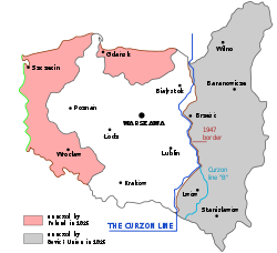
The territorial changes of Poland after World War II were very extensive. In 1945, following the Second World War
World War II
World War II, or the Second World War , was a global conflict lasting from 1939 to 1945, involving most of the world's nations—including all of the great powers—eventually forming two opposing military alliances: the Allies and the Axis...
, Poland's borders were redrawn following the decisions made at the Potsdam Conference
Potsdam Conference
The Potsdam Conference was held at Cecilienhof, the home of Crown Prince Wilhelm Hohenzollern, in Potsdam, occupied Germany, from 16 July to 2 August 1945. Participants were the Soviet Union, the United Kingdom, and the United States...
of 1945 at the insistence of the Soviet Union
Soviet Union
The Soviet Union , officially the Union of Soviet Socialist Republics , was a constitutionally socialist state that existed in Eurasia between 1922 and 1991....
. The eastern Polish territories, which the Soviet Union had occupied in 1939 (excluding the Białystok region) were permanently annexed, and most of their Polish inhabitants expelled. Today, these territories are part of Belarus
Belarus
Belarus , officially the Republic of Belarus, is a landlocked country in Eastern Europe, bordered clockwise by Russia to the northeast, Ukraine to the south, Poland to the west, and Lithuania and Latvia to the northwest. Its capital is Minsk; other major cities include Brest, Grodno , Gomel ,...
, Ukraine
Ukraine
Ukraine is a country in Eastern Europe. It has an area of 603,628 km², making it the second largest contiguous country on the European continent, after Russia...
, and Lithuania
Lithuania
Lithuania , officially the Republic of Lithuania is a country in Northern Europe, the biggest of the three Baltic states. It is situated along the southeastern shore of the Baltic Sea, whereby to the west lie Sweden and Denmark...
.
In turn, Poland received the Free City of Danzig
Free City of Danzig
The Free City of Danzig was a semi-autonomous city-state that existed between 1920 and 1939, consisting of the Baltic Sea port of Danzig and surrounding areas....
and former German territory east of the Oder-Neisse line
Oder-Neisse line
The Oder–Neisse line is the border between Germany and Poland which was drawn in the aftermath of World War II. The line is formed primarily by the Oder and Lusatian Neisse rivers, and meets the Baltic Sea west of the seaport cities of Szczecin and Świnoujście...
, consisting of the southern two-thirds of East Prussia
East Prussia
East Prussia is the main part of the region of Prussia along the southeastern Baltic Coast from the 13th century to the end of World War II in May 1945. From 1772–1829 and 1878–1945, the Province of East Prussia was part of the German state of Prussia. The capital city was Königsberg.East Prussia...
and most of Pomerania
Pomerania
Pomerania is a historical region on the south shore of the Baltic Sea. Divided between Germany and Poland, it stretches roughly from the Recknitz River near Stralsund in the West, via the Oder River delta near Szczecin, to the mouth of the Vistula River near Gdańsk in the East...
, Neumark
Neumark
Neumark comprised a region of the Prussian province of Brandenburg, Germany.Neumark may also refer to:* Neumark, Thuringia* Neumark, Saxony* Neumark * Nowe Miasto Lubawskie or Neumark, a town in Poland, situated at river Drwęca...
(East Brandenburg), and Silesia
Silesia
Silesia is a historical region of Central Europe located mostly in Poland, with smaller parts also in the Czech Republic, and Germany.Silesia is rich in mineral and natural resources, and includes several important industrial areas. Silesia's largest city and historical capital is Wrocław...
. The German population was forcibly expelled
Flight and expulsion of Germans from Poland during and after World War II
The flight and expulsion of Germans from Poland was the largest of a series of flights and expulsions of Germans in Europe during and after World War II...
before these "recovered territories
Recovered Territories
Recovered or Regained Territories was an official term used by the People's Republic of Poland to describe those parts of pre-war Germany that became part of Poland after World War II...
" were repopulated with Poles from central Poland and those expelled from the eastern regions. The area of Zaolzie
Zaolzie
Zaolzie is the Polish name for an area now in the Czech Republic which was disputed between interwar Poland and Czechoslovakia. The name means "lands beyond the Olza River"; it is also called Śląsk zaolziański, meaning "trans-Olza Silesia". Equivalent terms in other languages include Zaolší in...
, which had been annexed by Poland in the autumn of 1938, was returned to Czechoslovakia
Czechoslovakia
Czechoslovakia or Czecho-Slovakia was a sovereign state in Central Europe which existed from October 1918, when it declared its independence from the Austro-Hungarian Empire, until 1992...
, by order of Joseph Stalin
Joseph Stalin
Joseph Vissarionovich Stalin was the Premier of the Soviet Union from 6 May 1941 to 5 March 1953. He was among the Bolshevik revolutionaries who brought about the October Revolution and had held the position of first General Secretary of the Communist Party of the Soviet Union's Central Committee...
.
See also
- Territorial changes of PolandTerritorial changes of PolandPoland is a country in Central Europe bordered by Germany to the west; the Czech Republic and Slovakia to the south; Ukraine, Belarus and Lithuania to the east; and the Baltic Sea and Kaliningrad Oblast, a Russian exclave, to the north...
- Geography of PolandGeography of PolandPoland is a country in Central Europe with an area of 312,679 square kilometres , and mostly temperate climate. Generally speaking, Poland is an almost unbroken plain reaching from the Baltic Sea in the north, to the Carpathian Mountains in the south...
- Polish-Soviet border adjustment treaty
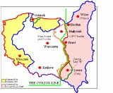
- Curzon LineCurzon LineThe Curzon Line was put forward by the Allied Supreme Council after World War I as a demarcation line between the Second Polish Republic and Bolshevik Russia and was supposed to serve as the basis for a future border. In the wake of World War I, which catalysed the Russian Revolution of 1917, the...