
Termon
Encyclopedia
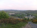
Termon is a village in the north of Donegal
, in the north of Ireland
.
It is situated eight miles from Letterkenny
, Donegal's main town and seven from Creeslough
. Termon is made up of many townlands including Currin, Doon, Drumlaurgagh, Drumbrick, Drumoughill, Cloncarney, Terhillion, Gortnalaragh, Clonkilly, Knocknabollan, Fawans, Drumdeevin, Drumfin, Barnes, Stragraddy, Ballybuninabber, Letterfad, Goal and Gurtin, Loughaskerry.
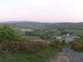
There are several hills close to Termon, including Lough Salt (469m), the hills of Barnes-Crockmore (the "Resting Bishop") at 324m, 349m & 307m respectively, and Stragraddy mountain (285m). All the hills offer stunning vistas along Donegal's Atlantic coast line or into the higher mountain country of Muckish
(666m) and Errigal (749m). Going out on the main R255 road one could turn for Gartan, birthplace of St.Colmcille (St.Columba)
or head to Glenveagh
National Park and its beautiful surroundings.
under pain of death, if they were caught the priest would find himself put into a barrel of nails and thrown of the cliff near Doon rock at 'Binn an Sagairt' or Hill of the Priest
There is also a mass rock in the Terhillion townland of Termon, Terhillion (Tirkillin) means place of little huts or churchyard.
The town land of Fawans has a mass rock which is high up in the townland, again lookouts would be posted at vantage points
s were inaugurated chieftain from Eighneachan 1200 to Niall Garbh 1603. Red Hugh O'Donnell
was inaugurated on 3 May 1592. Cahir Rua O'Dogherty, the last great Gealic chieftain to stand against English oppression was killed in this area 5 July 1608.
. Tommy & Trish McLaughlin have the Mountain Bar out in Stragraddy which is popular with locals on a Sunday night.
Termon Gaelic Athletic Association
(G.A.A.) based at the Burn Road runs both male and female teams in Gaelic
sports
in all age categories up to Senior level.
Termon Ladies are 2010 Donegal Senior Champions
Termon Ladies are the 2010 Ulster Senior Champions.
Termon is served well its National school for pupils aged 4/5 to 12 years of age. The old national school (1892) serves as a local nursery.
There is a Top shop Garage on the main N56 road to Letterkenny, serves for petrol, groceries and car maintenance
Donegal
Donegal or Donegal Town is a town in County Donegal, Ireland. Its name, which was historically written in English as Dunnagall or Dunagall, translates from Irish as "stronghold of the foreigners" ....
, in the north of Ireland
Ireland
Ireland is an island to the northwest of continental Europe. It is the third-largest island in Europe and the twentieth-largest island on Earth...
.
It is situated eight miles from Letterkenny
Letterkenny
Letterkenny , with a population of 17,568, is the largest town in County Donegal, part of the Province of Ulster in Ireland. The town is located on the River Swilly...
, Donegal's main town and seven from Creeslough
Creeslough
Creeslough is a village in County Donegal, part of the Province of Ulster in Ireland. It lies 12 km south of Dunfanaghy on the N56 road, 54 m above sea level and overlooking an arm of Sheephaven Bay...
. Termon is made up of many townlands including Currin, Doon, Drumlaurgagh, Drumbrick, Drumoughill, Cloncarney, Terhillion, Gortnalaragh, Clonkilly, Knocknabollan, Fawans, Drumdeevin, Drumfin, Barnes, Stragraddy, Ballybuninabber, Letterfad, Goal and Gurtin, Loughaskerry.
There are several hills close to Termon, including Lough Salt (469m), the hills of Barnes-Crockmore (the "Resting Bishop") at 324m, 349m & 307m respectively, and Stragraddy mountain (285m). All the hills offer stunning vistas along Donegal's Atlantic coast line or into the higher mountain country of Muckish
Muckish
Muckish is a distinctive flat-topped mountain in the Derryveagh Mountains of County Donegal, Republic of Ireland. At , it is the third-highest peak in the Derryveagh Mountains and the 163rd highest in Ireland. Muckish is also the most northern and second highest of the mountain chain called the...
(666m) and Errigal (749m). Going out on the main R255 road one could turn for Gartan, birthplace of St.Colmcille (St.Columba)
Columba
Saint Columba —also known as Colum Cille , Colm Cille , Calum Cille and Kolban or Kolbjørn —was a Gaelic Irish missionary monk who propagated Christianity among the Picts during the Early Medieval Period...
or head to Glenveagh
Glenveagh
Glenveagh — covering 170 square kilometres of hillside above Glenveagh Castle on the shore of Lough Veagh , some 20 km from Gweedore in County Donegal, Ireland — forms the heart of the Glenveagh National Park , the second largest national park in Ireland...
National Park and its beautiful surroundings.
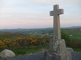
Significant Roman Catholic sites
Several sites around Termon are significant to the Roman Catholic faith in Donegal.Doon Well
Doon Well (Tobar an duin) was established by Lector O'Friel sometime around the 1670s. Doon Well's origins are pre-Christian, as evidenced by the following facts:- A 'togher' (ancient wooden road) runs underneath the bog adjacent to Doon Rock
- Bronze AgeBronze AgeThe Bronze Age is a period characterized by the use of copper and its alloy bronze as the chief hard materials in the manufacture of some implements and weapons. Chronologically, it stands between the Stone Age and Iron Age...
artefacts have been found near the well - The water used in the pagan inauguration ceremony of the O'Donnells would have been carried to the well. StationsStations of the CrossStations of the Cross refers to the depiction of the final hours of Jesus, and the devotion commemorating the Passion. The tradition as chapel devotion began with St...
and rosaryRosaryThe rosary or "garland of roses" is a traditional Catholic devotion. The term denotes the prayer beads used to count the series of prayers that make up the rosary...
are still 'walked' from St. ColumbaColumbaSaint Columba —also known as Colum Cille , Colm Cille , Calum Cille and Kolban or Kolbjørn —was a Gaelic Irish missionary monk who propagated Christianity among the Picts during the Early Medieval Period...
's chapel to Doon Well on HogmanayHogmanayHogmanay is the Scots word for the last day of the year and is synonymous with the celebration of the New Year in the Scottish manner...
(New Year's Eve) and May eve.
Mass Rocks
The Mass Rocks are also known as Carraig an Aifreann. A path takes you to the Mass Rocks which were used during penal times (1695–1741). There are thought to be several more in the Termon area and were generally in areas were people could meet, practice their faith and post a look out to warn the congregation. Priests usually said massMass (liturgy)
"Mass" is one of the names by which the sacrament of the Eucharist is called in the Roman Catholic Church: others are "Eucharist", the "Lord's Supper", the "Breaking of Bread", the "Eucharistic assembly ", the "memorial of the Lord's Passion and Resurrection", the "Holy Sacrifice", the "Holy and...
under pain of death, if they were caught the priest would find himself put into a barrel of nails and thrown of the cliff near Doon rock at 'Binn an Sagairt' or Hill of the Priest
There is also a mass rock in the Terhillion townland of Termon, Terhillion (Tirkillin) means place of little huts or churchyard.
The town land of Fawans has a mass rock which is high up in the townland, again lookouts would be posted at vantage points
Doon Rock
Doon Rock (120m approx) is the site where 25 O'DonnellO'Donnell
O'Donnell , which is derived from the forename Domhnaill were an ancient and powerful Irish family, kings, princes, and lords of Tír Chonaill in early times, and the chief allies and sometimes...
s were inaugurated chieftain from Eighneachan 1200 to Niall Garbh 1603. Red Hugh O'Donnell
Hugh Roe O'Donnell
Aodh Rua Ó Dónaill, anglicised as either Hugh Roe O'Donnell or Red Hugh O'Donnell , was An Ó Domhnaill and Rí of Tir Chonaill . He led the Irish forces against the English conquest of Ireland from 1593 and helped to lead the Nine Years' War from 1595 to 1603...
was inaugurated on 3 May 1592. Cahir Rua O'Dogherty, the last great Gealic chieftain to stand against English oppression was killed in this area 5 July 1608.
St. Columba's Chapel
Termon is served by St. Columba's Chapel (1854–present). The Parish Priest is Fr. Patrick McHugh.Ethne's Well
Ethne's Well (Turas an Ri), in the Barnes townland, is named after Columba's mother. Ethne is strongly associated with the area. This holy well had stations performed on 9 June for nine nights.St.Glassan
St.Glassan (Glasny) is a saint of the parish of whom little is known. The Martyrology of Donegal gives his feast day as 1 October. The grave of Father Glassan (Frater Cassians) is thought to be in the Stragraddy townland of Termon.Local infrastructure
To eat and drink in Termon a menu is provided all day at the Lagoon Bar run by Shiela & John McCafferty. This bar with its shop next door run by Kevin McCafferty is on the main N56 routeN56 road (Ireland)
The N56 road is a national secondary road in Ireland that runs from Donegal town to Letterkenny. As originally designated, it included the section of the N13 between Stranorlar and Letterkenny, forming a circular route including parts of the N15....
. Tommy & Trish McLaughlin have the Mountain Bar out in Stragraddy which is popular with locals on a Sunday night.
Termon Gaelic Athletic Association
Gaelic Athletic Association
The Gaelic Athletic Association is an amateur Irish and international cultural and sporting organisation focused primarily on promoting Gaelic games, which include the traditional Irish sports of hurling, camogie, Gaelic football, handball and rounders...
(G.A.A.) based at the Burn Road runs both male and female teams in Gaelic
Gaelic Athletic Association
The Gaelic Athletic Association is an amateur Irish and international cultural and sporting organisation focused primarily on promoting Gaelic games, which include the traditional Irish sports of hurling, camogie, Gaelic football, handball and rounders...
sports
Gaelic games
Gaelic games are sports played in Ireland under the auspices of the Gaelic Athletic Association. The two main games are Gaelic football and hurling...
in all age categories up to Senior level.
Termon Ladies are 2010 Donegal Senior Champions
Termon Ladies are the 2010 Ulster Senior Champions.
Termon is served well its National school for pupils aged 4/5 to 12 years of age. The old national school (1892) serves as a local nursery.
There is a Top shop Garage on the main N56 road to Letterkenny, serves for petrol, groceries and car maintenance
The OwenCarrow Viaduct Disaster
Neolithic and Historical sites/stones
- Megalithic tomb 1 (Grid.ref C107248) - Barnes townland
- Megalithic tomb 2 (Grid.ref C107219) - Gortnalaragh townland, known locally as Dermot and Groinna, 2 stones visible from the Terhillion Rd
- Megalithic tomb 3 (Grid Ref C119211) - Drumbrick townland
- Standing StoneStanding stoneStanding stones, orthostats, liths, or more commonly megaliths are solitary stones set vertically in the ground and come in many different varieties....
s 1 (Grid ref C108245) - Barnes townland - Standing Stones 2 (Grid ref C109241) - Barnes townland (Ogham standing stones) - these are thought to be the original boundaries of 'An Tearmann' denoting sanctuary, as those seeking it were thought to be within the Kilmacrenan Abbey
- Cillin 1 (Grid ref C109240) - Barnes townland
- Cillin 2 (Grid ref C125206) - Clonkilly townland
- Ring FortRingfortRingforts are circular fortified settlements that were mostly built during the Iron Age , although some were built as late as the Early Middle Ages . They are found in Northern Europe, especially in Ireland...
(Grid ref C121216) - Drumbrick townland, situated at the top of Drumbrick hill, visible from the Burn road
Rivers and Loughs
- The Lurgy runs through Termon.Irish - An Lorgaigh
- Clonkillymore Lough
- Clonkillybeg Lough
- Doon Lough
- Cloncarney Lough
- Lough Darragh
- Lough Askerry
- Lough Mnafin
- Lough Acrappin - Top of Drumfin
- Lough Acrabane - Barnes Gap
See also
- List of towns and villages in Ireland