
Tera Department
Encyclopedia
Téra is a department
of the Tillabéri Region in Niger
. Its capital lies at the city of Téra
.
. Today primarily a home to speakers of the Southern Songhai language, prior to the Songhai Empire
, the area was populated by Gourmantche and Mossi peoples. By the 16th century Tera was one of the many small states which survived the destruction of the Songhai Empire, with many Songhai communities resettling into what is today Niger from the north. The Dendi
Songhai state of the 17th century ruled the area, before dividing into several small states, each ruled by an Askia of Songhai noble lineage. In the late 19th century, the Songhai city state around Tera was in almost continual conflict with Tuareg groups in the north and east, with the city of Tera sacked and destroyed as late as 1885. Forces from Usman dan Fodio
's Sokoto Caliphate took the area several times in the early 19th century as well, but were pushed back by Djerma
forces in the regions to the southeast, though semi-nomadic Fula
communities were present in the area from at least the 18th century.
peoples, large Fula
, Gourmantche and Buzu populations live in the area as well. Tera is one of the few places where the Kaado Southern Songhay dialect is still spoken, although peoples are more likely to call themselves (and their language) "Songhay" or "Zarma".
. To the west, the area laterite
plateaus broken by occasional mesa
s. Tera Department lies entirely within the Sahel
region, and receives between 400mm-500mm of rain a year. The vegetation is sparse, with dry scrub forests and grasses, except in the land along the Niger River, which is lush with wild vegetation as well as vegetable and fruit gardens. In the northern section of Tera Department the Niger River forms a broad channel, where Hippopotamus
and other wildlife are still common.
The Kokoro and Namga Wetlands in Tera Department was designated a Ramsar
site in 2001. Covering 668km2 the wetland hosts migratory birdlife and is important to the local ecology.
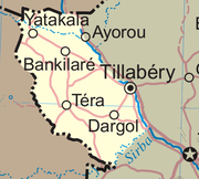
The Departmental seat, a town of almost 20,000, lies on a tributary of the Niger, dammed to provide a small lake. Its main tarred road -- the RN4 -- passes south from Tera to Diagourou
(a Fula town 15km away), Dargol
and Gotheye
, crossing the Niger at Bac Farie by ferry. The RN1
road continues to Niamey
, 180km from Tera. To the north of the department lie the small towns of Yatakala, Labezanga (where the Niger crosses to Mali
), Bankilare
(a mainly Tuareg town) and Kokoro
in the center of the department. The cities of Ayorou and Tillaberi
lie just across the Niger in Tillaberi Department
to the east.
The department is bordered to the south by Say Department
and Kollo Department
, along the course of the Sirba River
, a seasonal tributary of the Niger.
being the primary crop.
The area contains a major road connecting Niger with Dori
Burkina Faso
, making Tera a transport and trade hub. Tera also has an airport, a 3900ft/1189m strip designated DRRE.
The Samira Hill Gold Mine
(Namaga concession) began producing gold
in 2004 from the Tera greenstone belt
which surrounds Koma Bangou, the country’s largest artisanal mining site. The mine is operated by SML (Societe des Mines du Liptako), a joint venture between Moroccan Societe SEMAFO Inc and Canadian ETRUSCAN, along with a Nigerien 20% stake.
The traditional and distinctive Tera-Tera fabric is produced by Djerma artisans in Tera. Strips of striped, dyed handloomed fabric are sewn into larger blankets and are used in traditional marriage ceremonies and exported abroad.
Mali
were administered from Tera, while prior to 1922, Dori
in modern Burkina Faso
was administered from Tera, as part of the Niger colonial military territory of French West Africa
. When the French divided French Upper Volta
colony between its neighbors in 1932, the districts of Fada and most of Dori
(excluding the canton of Aribinda) were added to Niger, most in the (then) Cercle
of Tera. Upper Volta was reconstituted in 1946, but the Tera Cercle's boundary remained a source of dispute until the Niger-Upper Volta protocol of agreement on their common boundary was signed at Niamey on June 23, 1964, fixing the present western border of the Tera administrative entity.
Departments of Niger
||The Regions of Niger are subdivided into 63 Departments . Before the devolution program on 1999-2005, these Departments were styled arrondissements. Confusingly, the next level up had, before 2002-2005 been styled Departments. Prior to a revision in 2011, there had been 36 Departments. A draft...
of the Tillabéri Region in Niger
Niger
Niger , officially named the Republic of Niger, is a landlocked country in Western Africa, named after the Niger River. It borders Nigeria and Benin to the south, Burkina Faso and Mali to the west, Algeria and Libya to the north and Chad to the east...
. Its capital lies at the city of Téra
Téra
Téra is a town in the Tillabéri Region, Tera Department of Niger. It is situated 175 km north-west of the capital Niamey, close to the border with Burkina Faso. It is mainly inhabited by Songhai, Fulani, Gourmantche and Buzu ethnic groups. The majority of the population are farmers.- Commerce...
.
History
Téra Department covers most of the historic territory of LiptakoLiptako
Liptako is an historic region of West Africa. It today falls in eastern Burkina Faso, southwestern Niger and a small portion of southeast central Mali. A hilly region beginning on the right back of the Niger river, Liptako is usually associated with the Liptako Emirate, an early 19th century...
. Today primarily a home to speakers of the Southern Songhai language, prior to the Songhai Empire
Songhai Empire
The Songhai Empire, also known as the Songhay Empire, was a state located in western Africa. From the early 15th to the late 16th century, Songhai was one of the largest Islamic empires in history. This empire bore the same name as its leading ethnic group, the Songhai. Its capital was the city...
, the area was populated by Gourmantche and Mossi peoples. By the 16th century Tera was one of the many small states which survived the destruction of the Songhai Empire, with many Songhai communities resettling into what is today Niger from the north. The Dendi
Dendi
Dendi is the name of several African-related subjects:* Dendi Kingdom* Dendi is a district or woreda in Ethiopia;* Mount Dendi, also in Ethiopia;* Dendi people is one of the ethnic groups living in Benin and Niger;...
Songhai state of the 17th century ruled the area, before dividing into several small states, each ruled by an Askia of Songhai noble lineage. In the late 19th century, the Songhai city state around Tera was in almost continual conflict with Tuareg groups in the north and east, with the city of Tera sacked and destroyed as late as 1885. Forces from Usman dan Fodio
Usman dan Fodio
Shaihu Usman dan Fodio , born Usuman ɓii Foduye, was the founder of the Sokoto Caliphate in 1809, a religious teacher, writer and Islamic promoter. Dan Fodio was one of a class of urbanized ethnic Fulani living in the Hausa States in what is today northern Nigeria...
's Sokoto Caliphate took the area several times in the early 19th century as well, but were pushed back by Djerma
Djerma
The Zarma people , are a people of westernmost Niger and adjacent areas of Burkina Faso, Benin, Ghana and Nigeria. The Zarma language is one of the Songhai languages, a branch of the Nilo-Saharan language family...
forces in the regions to the southeast, though semi-nomadic Fula
Fula people
Fula people or Fulani or Fulbe are an ethnic group spread over many countries, predominantly in West Africa, but found also in Central Africa and Sudanese North Africa...
communities were present in the area from at least the 18th century.
Population
With a majority of Songhai - DjermaDjerma
The Zarma people , are a people of westernmost Niger and adjacent areas of Burkina Faso, Benin, Ghana and Nigeria. The Zarma language is one of the Songhai languages, a branch of the Nilo-Saharan language family...
peoples, large Fula
Fula people
Fula people or Fulani or Fulbe are an ethnic group spread over many countries, predominantly in West Africa, but found also in Central Africa and Sudanese North Africa...
, Gourmantche and Buzu populations live in the area as well. Tera is one of the few places where the Kaado Southern Songhay dialect is still spoken, although peoples are more likely to call themselves (and their language) "Songhay" or "Zarma".
Geography
The Tera department slopes down to the east, bordered by the Niger RiverNiger River
The Niger River is the principal river of western Africa, extending about . Its drainage basin is in area. Its source is in the Guinea Highlands in southeastern Guinea...
. To the west, the area laterite
Laterite
Laterites are soil types rich in iron and aluminium, formed in hot and wet tropical areas. Nearly all laterites are rusty-red because of iron oxides. They develop by intensive and long-lasting weathering of the underlying parent rock...
plateaus broken by occasional mesa
Mesa
A mesa or table mountain is an elevated area of land with a flat top and sides that are usually steep cliffs. It takes its name from its characteristic table-top shape....
s. Tera Department lies entirely within the Sahel
Sahel
The Sahel is the ecoclimatic and biogeographic zone of transition between the Sahara desert in the North and the Sudanian Savannas in the south.It stretches across the North African continent between the Atlantic Ocean and the Red Sea....
region, and receives between 400mm-500mm of rain a year. The vegetation is sparse, with dry scrub forests and grasses, except in the land along the Niger River, which is lush with wild vegetation as well as vegetable and fruit gardens. In the northern section of Tera Department the Niger River forms a broad channel, where Hippopotamus
Hippopotamus
The hippopotamus , or hippo, from the ancient Greek for "river horse" , is a large, mostly herbivorous mammal in sub-Saharan Africa, and one of only two extant species in the family Hippopotamidae After the elephant and rhinoceros, the hippopotamus is the third largest land mammal and the heaviest...
and other wildlife are still common.
The Kokoro and Namga Wetlands in Tera Department was designated a Ramsar
Ramsar Convention
The Ramsar Convention is an international treaty for the conservation and sustainable utilization of wetlands, i.e., to stem the progressive encroachment on and loss of wetlands now and in the future, recognizing the fundamental ecological functions of wetlands and their economic, cultural,...
site in 2001. Covering 668km2 the wetland hosts migratory birdlife and is important to the local ecology.
The Departmental seat, a town of almost 20,000, lies on a tributary of the Niger, dammed to provide a small lake. Its main tarred road -- the RN4 -- passes south from Tera to Diagourou
Diagourou
Diagourou is a town in the Coalla Department of Gnagna Province in eastern Burkina Faso. The town has a population of 1,165....
(a Fula town 15km away), Dargol
Dargol
-References:...
and Gotheye
Gothèye
-References:...
, crossing the Niger at Bac Farie by ferry. The RN1
Route nationale 1 (Niger)
The Route nationale no. 1 is an important highway in the African country of Niger. It connects the east part of the country to the west. RN1 runs approximately from Niamey in the west to N'Guigmi in the east, via Dosso, Maradi, Zinder, and Diffa. The first large paved section, between Gouré and...
road continues to Niamey
Niamey
-Population:While Niamey's population has grown steadily since independence, the droughts of the early 1970s and 1980s, along with the economic crisis of the early 1980s, have propelled an exodus of rural inhabitants to Niger's largest city...
, 180km from Tera. To the north of the department lie the small towns of Yatakala, Labezanga (where the Niger crosses to Mali
Mali
Mali , officially the Republic of Mali , is a landlocked country in Western Africa. Mali borders Algeria on the north, Niger on the east, Burkina Faso and the Côte d'Ivoire on the south, Guinea on the south-west, and Senegal and Mauritania on the west. Its size is just over 1,240,000 km² with...
), Bankilare
Bankilare
Bankilaré is a village and rural commune in Niger. Bankilaré commune, centered on the town of the same name, is in Téra Department, Tillabéri Region, in the northwestern corner of the country...
(a mainly Tuareg town) and Kokoro
Kokoro
is a novel by the Japanese author Natsume Sōseki. It was first published in 1914 in serial form in the Japanese newspaper Asahi Shinbun. While the title literally means "heart", the word contains shades of meaning, and can be translated as "the heart of things" or "feeling"...
in the center of the department. The cities of Ayorou and Tillaberi
Tillabéri
Tillabéri is a town in northwest Niger. It is situated 120 km northwest of the capital Niamey on the River Niger. It is an important market town and administrative center, it is capital of the department of Tillabéri and Tillabéri Region. The town had a population of over 16000 at the 2001 census...
lie just across the Niger in Tillaberi Department
Tillabéri Department
Tillabéri is a department of the Tillabéri Region in Niger. Its capital lies at the city of Tillabéri, and contains the Communes of Ayorou , Anzourou, Dessa, Kourteye, and Sinder. Tillabéri is also the capitol of Tillabéri Region...
to the east.
The department is bordered to the south by Say Department
Say Department
Say is a department of the Tillabéri Region in Niger. Its capital city is Say, and includes the towns of Guéladjo, Tamou, and Torodi. It abuts the urban Region of Niamey, and lies across the Niger River to the southwest of the capital. It extends to the Burkina Faso border over 60km to the west,...
and Kollo Department
Kollo Department
Kollo is a department of the Tillabéri Region in Niger. Its capital lies at the city of Kollo, and includes the towns of N'Dounga, Fakara, Hamdallay, Karma, Kirtachi, Kouré, Lamordé, Liboré, and Namaro.-References:...
, along the course of the Sirba River
Sirba River
The Sirba River is a tributary of the Niger River in western Africa. The Sirba arises in Burkina Faso and flows east, crosses into Niger and then forms a short part of the international border between the two countries. It meets the Niger River at the midway point between the settlements of Gothèye...
, a seasonal tributary of the Niger.
Economy
Most of the population is engaged in agriculture, with MilletMillet
The millets are a group of small-seeded species of cereal crops or grains, widely grown around the world for food and fodder. They do not form a taxonomic group, but rather a functional or agronomic one. Their essential similarities are that they are small-seeded grasses grown in difficult...
being the primary crop.
The area contains a major road connecting Niger with Dori
Dori, Burkina Faso
Dori is a town in northeastern Burkina Faso. It is located at around . It is the capital of Sahel Region and has a population of 17 675. The main ethnic group is the Fula .- Mines :...
Burkina Faso
Burkina Faso
Burkina Faso – also known by its short-form name Burkina – is a landlocked country in west Africa. It is surrounded by six countries: Mali to the north, Niger to the east, Benin to the southeast, Togo and Ghana to the south, and Côte d'Ivoire to the southwest.Its size is with an estimated...
, making Tera a transport and trade hub. Tera also has an airport, a 3900ft/1189m strip designated DRRE.
The Samira Hill Gold Mine
Samira Hill Gold Mine
The Samira Hill Gold Mine is a Gold mine in Téra Department of the Tillabéri Region in Niger. Opened in late 2004, it is the first industrial scale gold mine in the nation, and while operated by a Canadian/Moroccan consortia, the government of Niger owns both a 20% stake in its operation, and...
(Namaga concession) began producing gold
Gold
Gold is a chemical element with the symbol Au and an atomic number of 79. Gold is a dense, soft, shiny, malleable and ductile metal. Pure gold has a bright yellow color and luster traditionally considered attractive, which it maintains without oxidizing in air or water. Chemically, gold is a...
in 2004 from the Tera greenstone belt
Greenstone belt
Greenstone belts are zones of variably metamorphosed mafic to ultramafic volcanic sequences with associated sedimentary rocks that occur within Archaean and Proterozoic cratons between granite and gneiss bodies....
which surrounds Koma Bangou, the country’s largest artisanal mining site. The mine is operated by SML (Societe des Mines du Liptako), a joint venture between Moroccan Societe SEMAFO Inc and Canadian ETRUSCAN, along with a Nigerien 20% stake.
The traditional and distinctive Tera-Tera fabric is produced by Djerma artisans in Tera. Strips of striped, dyed handloomed fabric are sewn into larger blankets and are used in traditional marriage ceremonies and exported abroad.
Contested international border
Prior to 1910, portions of what are now AnsongoAnsongo
Ansongo is a Rural Commune and small town in the Gao Region of south-eastern Mali. The town lies on the left bank of the Niger River 90 km south of Gao. It is the administrative center for the surrounding Ansongo Cercle. The commune has an area of 445 km2 and had a population of 32,709...
Mali
Mali
Mali , officially the Republic of Mali , is a landlocked country in Western Africa. Mali borders Algeria on the north, Niger on the east, Burkina Faso and the Côte d'Ivoire on the south, Guinea on the south-west, and Senegal and Mauritania on the west. Its size is just over 1,240,000 km² with...
were administered from Tera, while prior to 1922, Dori
Dori
Dori may refer to:Place names:* Dori, Burkina Faso, a city in Burkina Faso, West Africa** Dori Department** Roman Catholic Diocese of Dori** Dori AirportBallet terminology...
in modern Burkina Faso
Burkina Faso
Burkina Faso – also known by its short-form name Burkina – is a landlocked country in west Africa. It is surrounded by six countries: Mali to the north, Niger to the east, Benin to the southeast, Togo and Ghana to the south, and Côte d'Ivoire to the southwest.Its size is with an estimated...
was administered from Tera, as part of the Niger colonial military territory of French West Africa
French West Africa
French West Africa was a federation of eight French colonial territories in Africa: Mauritania, Senegal, French Sudan , French Guinea , Côte d'Ivoire , Upper Volta , Dahomey and Niger...
. When the French divided French Upper Volta
French Upper Volta
Upper Volta was a colony of French West Africaestablished on March 1, 1919, from territories that had been part of the colonies of Upper Senegal and Niger and the Côte d'Ivoire...
colony between its neighbors in 1932, the districts of Fada and most of Dori
(excluding the canton of Aribinda) were added to Niger, most in the (then) Cercle
Cercle
Cercle is French for circle. It can also refer to:* Cercle an administrative unit of the French Overseas Empire* Cercle , the Malian administrative unit** The specific Cercles of Mali...
of Tera. Upper Volta was reconstituted in 1946, but the Tera Cercle's boundary remained a source of dispute until the Niger-Upper Volta protocol of agreement on their common boundary was signed at Niamey on June 23, 1964, fixing the present western border of the Tera administrative entity.
Further reading
- Hammadou Soumalia. Traditions des Songhay de Tera, Niger (Hommes et sociétés) Editions Karthala, Niger (1998)
External links
- Photographs and family stories of students from Tera at Africa Speaks: Life Stories (1998)
- Worldvision and Islamic Relief projects in Tera during the 2004 famine.
- Catholic Relief Services Tera project, working with sesame farming.
- brighton2capetown:Niger. Story and photos of a trip through Tera on motorcycle.