
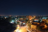
Niamey
Encyclopedia
Population
| Year | Population (estimate) |
|---|---|
| 1901 | 600 |
| 1930 | 3,000 |
| 1960 | 30,000 |
| 1980 | 250,000 |
| 2005 | 750,000 |
While Niamey's population has grown steadily since independence, the droughts of the early 1970s and 1980s, along with the economic crisis of the early 1980s, have propelled an exodus of rural inhabitants to Niger's largest city. Under the Military government of General Seyni Kountché
Seyni Kountché
Seyni Kountché was a Nigerien military officer who led a 1974 coup d'état that deposed the government of Niger's first president, Hamani Diori. He ruled the country as military head of state from 1974 to 1987...
, there were strict controls on residency, and the government would regularly round up and "deport" those without permits back to their villages. The growing freedoms of the late 1980s and 1990s, along with the Tuareg Rebellion of 1990s and famine in the 2000s, have reinforced the process of immigration, with large informal settlements appearing on the outskirts of the cities. Noticeable in the city's centre since the 1980s are groups of poor, young, or handicapped beggars.
Within the richer or more trafficked neighbourhoods, these beggars have in fact formed a well regulated hierarchical system in which beggars garner sadaka (alms
Alms
Alms or almsgiving is a religious rite which, in general, involves giving materially to another as an act of religious virtue.It exists in a number of religions. In Philippine Regions, alms are given as charity to benefit the poor. In Buddhism, alms are given by lay people to monks and nuns to...
) according to cultural and religious norms.
Sites and institutions
Attractions in the city include the Niger National Museum, incorporating a zooZoo
A zoological garden, zoological park, menagerie, or zoo is a facility in which animals are confined within enclosures, displayed to the public, and in which they may also be bred....
, a museum of vernacular architecture
Vernacular architecture
Vernacular architecture is a term used to categorize methods of construction which use locally available resources and traditions to address local needs and circumstances. Vernacular architecture tends to evolve over time to reflect the environmental, cultural and historical context in which it...
, a craft centre, and exhibits including dinosaur
Dinosaur
Dinosaurs are a diverse group of animals of the clade and superorder Dinosauria. They were the dominant terrestrial vertebrates for over 160 million years, from the late Triassic period until the end of the Cretaceous , when the Cretaceous–Paleogene extinction event led to the extinction of...
skeleton
Skeleton
The skeleton is the body part that forms the supporting structure of an organism. There are two different skeletal types: the exoskeleton, which is the stable outer shell of an organism, and the endoskeleton, which forms the support structure inside the body.In a figurative sense, skeleton can...
s and the Tree of Ténéré. There are also American, French
France
The French Republic , The French Republic , The French Republic , (commonly known as France , is a unitary semi-presidential republic in Western Europe with several overseas territories and islands located on other continents and in the Indian, Pacific, and Atlantic oceans. Metropolitan France...
and Nigerien cultural centres, seven major market centers including the large Niamey Grand Market
Niamey Grand Market
The Niamey Grand Market is the largest market and shopping center in Niamey, the capital and largest city in the West African state of Niger.-Location:...
, a traditional wrestling
Wrestling
Wrestling is a form of grappling type techniques such as clinch fighting, throws and takedowns, joint locks, pins and other grappling holds. A wrestling bout is a physical competition, between two competitors or sparring partners, who attempt to gain and maintain a superior position...
arena and a horse track.
The city is also the site of Diori Hamani International Airport
Diori Hamani International Airport
Diori Hamani International Airport is an airport in Niamey, the capital of Niger. It is located in the south eastern suburbs of the city, along the Route Nationale 1, the major highway linking Niamey with the east of the nation. The airport complex also includes the major base for the Armed Forces...
, the National School of Administration
National School of Administration
National School of Administration can refer to:*École nationale d'administration, Strasbourg, France*École nationale d'administration publique, Quebec City, Quebec, Canada*China National School of Administration, Beijing, China...
, Abdou Moumouni University, the Higher Institute of Mining, Industry and Geology
Higher Institute of Mining, Industry and Geology
Higher Institute of Mining, Industry and Geology is the only Institute of technology in Niger dedicated to the formation of engineers and technicians...
which lies on the right bank of the river, and many institutes (Centre numérique de Niamey, IRD
Institut de recherche pour le développement
The Institut de recherche pour le développement is a French public science and technology research institute under the joint authority of the French ministries in charge of research and overseas development....
, ICRISAT, Hydrologic Institute, etc.) AMU has seen a number of protest actions over the years, including the 2006 Abdou Moumouni University protests
2006 Abdou Moumouni University protests
The 2006 Abdou Moumouni University protests were student protests which took place during June 2006 in Niamey, Niger over the non-payment of grants to students at the university. The protests temporarily shut down Abdou Moumouni University, the only public university in the country. Students set...
.
Several hospitals are located in Niamey, including the National Hospital and Lamordé University Hospital
Lamordé University Hospital
Lamordé University Hospital or Lamordé National Hospital is a teaching hospital in Niamey, Niger. Affiliated with Abdou Moumouni University, the facility has 72 beds. It was the first public hospital in Niger to provide fistula repair services....
.
In December 2005 it was the host of the Jeux de la Francophonie
Jeux de la Francophonie
The Jeux de la Francophonie are a combination of artistic and sporting events for the Francophonie, mostly French speaking nations, held every four years since 1989, partly as a counterweight to the Commonwealth Games.-Editions:-Sports:There were four sports...
.
Departments of Niger
||The Regions of Niger are subdivided into 63 Departments . Before the devolution program on 1999-2005, these Departments were styled arrondissements. Confusingly, the next level up had, before 2002-2005 been styled Departments. Prior to a revision in 2011, there had been 36 Departments. A draft...
of Tillabéri
Tillabéri
Tillabéri is a town in northwest Niger. It is situated 120 km northwest of the capital Niamey on the River Niger. It is an important market town and administrative center, it is capital of the department of Tillabéri and Tillabéri Region. The town had a population of over 16000 at the 2001 census...
.
Religion
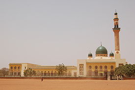
More than 90% of Niger is populated by Muslims. Niamey hosts the largest mosqueMosque
A mosque is a place of worship for followers of Islam. The word is likely to have entered the English language through French , from Portuguese , from Spanish , and from Berber , ultimately originating in — . The Arabic word masjid literally means a place of prostration...
in the country, the Grand Mosque of Niamey
Grande Mosquée
The Grande Mosquée is an Islamic mosque in Niamey, Niger. The largest mosque in the city, it is located along Islam Avenue. Funded with money from Libya, the mosque features a minaret with 171 steps from top to bottom.-References:...
. The city is the headquarters of the Roman Catholic Archdiocese of Niamey.
Governance
The city of Niamey itself is governed as an autonomous first-level administrative block, the Niamey Urban Community (fr. Communauté Urbaine de Niamey, CUN). It includes five Urban CommunesCommunes of Niger
The Departments of Niger are subdivided into communes. As of 2005, in the seven Regions and one Capital Area, there were 36 départements, divided into 265 communes, 122 cantons and 81 groupements...
, divided into 44 "Districts" and 99 "Quartiers", including formerly independent towns. It is a co-equal first division subdivision with the seven Regions of Niger
Regions of Niger
||Niger is divided into 7 Regions . Each department's capital is the same as its name.-Current regions:*Agadez Region*Diffa Region*Dosso Region*Maradi Region*Tahoua Region*Tillabéri Region*Zinder Region...
. The Niamey Urban Community includes an administration and Governor appointed by national leaders. Like the rest of Niger, Niamey has seen a decentralization of governance since 2000. Government Ordinance n°2010-56 and Presidential Decree n°2010-679 of September 2010 mandated an elected City Council for the city of Niamey, subsumed under the CUN. This excludes some outlying areas of the CUN. Forty-five councilors are popularly elected and in turn elect the Mayor of the City of Niamey. In July 2011 the first Mayor under the new system, Oumarou Dogari Moumouni, was installed by the Governor of the CUN Mrs. Kané Aichatou Boulama and the City Council. The City Council and Mayor have limited roles compared the CUN Governor. Niamey has a third layer of government in the Commune
Communes of Niger
The Departments of Niger are subdivided into communes. As of 2005, in the seven Regions and one Capital Area, there were 36 départements, divided into 265 communes, 122 cantons and 81 groupements...
system. Each Commune elects its own council, and outside major cities, these function like independent cities. Niamey and other major cities have been, since the advent of decentralization, developing coordination of Commune governments in large cities made up of multiple Communes.
Under this devolution process formalised in the 1999 Constitution of Niger
Constitution of Niger
The Republic of Niger has had seven constitutions, two substantial constitutional revisions, and two periods of rule by decree since its independence from French colonial rule in 1960...
, the CUN contains five "Urban Communes" and no "Rural Communes". As all Nigerien Urban Communes, they are divided into Quarters ("Quartiers") with elected boards.
The CUN includes 99 Quarters:
- Niamey I commune, 20 Quarters
- Niamey II commune, 17 Quarters
- Niamey III commune, 17 Quarters
- Niamey IV commune, 17 Quarters
- Niamey V commune, 28 Quarters
The CUN includes land where there were formerly several surrounding towns and villages which the city of Niamey has now annexed. These include Soudouré
Soudouré
Soudouré is a village in western Niger. It is located along the Niger River northwest of the capital city, Niamey. It is located in the Niamey Capital District....
, Lamordé, Gamkallé, Yantala, and Gaweye.
The CUN covers a territory of 239.30 km2, or 0.02% of the nation's territory.
Until 1998, all of greater Niamey was part of Tillabery Region, which prior to 1992 was named the Niamey Department. The CUN remains surrounded on all sides by Tillabery Region.
External links
- Niger Assemblee Nationale official website
- Mission of Niger to the United Nations official website
- BBC News Country Profile - Niger
- CIA World Factbook - Niger
- US State Department - Niger includes Background Notes, Country Commercial Guides and major reports
- MSN Map