
Tenryu River
Encyclopedia
The is a river arising from Lake Suwa
in Okaya
, Nagano Prefecture
, grazing Aichi Prefecture
and flowing through western Shizuoka Prefecture
in central Honshū
, Japan
. With a length of 213 km (132.4 mi), it is Japan's ninth longest river.
which form the border between Shizuoka and Nagano Prefectures and the Kiso Mountains
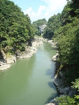
. This area is characterized by heavy rainfall (up to 3000 mm per year) and deep V-shaped valleys. Continuing south through Shizuoka Prefecture, the river drains a wide coastal plain noted for fruit and rice production. The city of Hamamatsu
is near the river mouth at the Philippine Sea
.
records as the for its fast, turbulent flow and its propensity to flood. The upper portion of the river (in Shinano Province
) was referred to as the Tenryūgawa, whereas the lower portion (in Tōtōmi Province
) was often referred to as the . In various entries in the national historical chronicle Shoku Nihongi
, flooding of the river is mentioned in the years 710 AD and 765 AD. Records through the Heian period
and Kamakura period
are sparse, but from the Muromachi period
, increasing efforts at flood control
were made by various warlords and landholders along the river by construction of dikes, levee
s, and channels. With the occupation of Hamamatsu Castle
by Tokugawa Ieyasu
, considerable efforts were made to increase the revenues of Tōtōmi Province through creation of new rice fields with irrigation from the Tenryū River. However, flooding remained a problem, including a great flood in 1674 which washed away many of the earthen works of previous centuries.
 During the Edo period
, the Tōkaidō
developed as the major highway linking Edo
with Kyoto
, and daimyo
from the western domains were forced to travel on a regular basis to Edo to attend to the shogun
in a system known as sankin kotai
. However, the Tokugawa shogunate
prohibited the building of bridges over major rivers as a security measure. As depicted in contemporary ukiyoe prints by artists such as Hokusai
, travelers crossed the river on ferryboats, as the current was too fast and too deep for fording. In cases of bad weather or high waters, they were forced to stay several days (or even several weeks) beside the river at post stations
such as Mitsuke-juku
.
The river was bridged shortly after the Meiji Restoration
by road and railroad bridges. Today the Tōkaidō Shinkansen express train
crosses the river in a few seconds.
, and it was not until the Taishō period
that development began on the Tenryū River. Private entrepreneur Fukuzawa Momosuke founded the , which later became before it was nationalized into the pre-war government monopoly in 1938. The first dam on the main stream of the Tenryu River, the Yasuoka Dam
was completed in 1935. This was followed by the Iwakura Dam
in 1938. The Hiraoka Dam
was started in 1938, but completed until 1951 due to the start of World War II
.
 After the end of World War II, the American occupation authorities
ordered the dissolution of Nippon Hassoden, which was divided into regional power companies. Central Japan came under Chubu Electric Power, which inherited the various dams and projects on the Tenryū River, all of which were located in Nagano Prefecture. For develop of the hydroelectric potential of the river in Shizuoka Prefecture, the government turned to the Electric Power Development Company
. The new company, in part through foreign aid loans from the United Nations
, and with the use of new dam technologies completed the huge Sakuma Dam
in the 1956, at the time the 10th largest in the world. Further dams were completed in the 1960s and 1970s until the completion of the Funagira Dam
in 1976 brought development of the Tenryū River to a close. These dams have altered the once abundant flow of the river, and the lower reaches of the river near its mouth are almost dry.
This has had the unexpected effect of greatly increased erosion on the coastline of Shizuoka Prefecture, near Hamamatsu, especially around the Nakatajima Sand Dunes
, while at the same time, the vast amount of sand and silt trapped in various dams upstream have resulted in greatly lower than projected operational lives. Methods to increase dredging in dams and to channel the silt and sand downstream to the ocean via a series of pipelines have been explored.
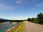
runs along the lower reaches of the Tenryū River valley, whereas the Iida Line
runs along the upper reaches of the river into upper Shizuoka and Nagano prefectures, with a stop at Sakuma Station
near the namesake dam. The Tenryū River valley is also partly within the Tenryū-Okumikawa Quasi-National Park
.
34.648443°N 137.790722°W (mouth)
Lake Suwa
is a lake in the central part of Nagano Prefecture, Japan. It ranks 24th in Japan in surface area.Lake Suwa is the site of , an interesting natural phenomenon. The lake has a natural hot spring under the surface, so that when the top freezes in the winter, the lower waters are still warm and...
in Okaya
Okaya, Nagano
is a city located in Nagano, Japan. It was founded on 1 April 1936.As of May 1, 2011, the city has an estimated population of 52,556, with 19,536 households and a population density of 616.93 persons per km²...
, Nagano Prefecture
Nagano Prefecture
is a prefecture of Japan located in the Chūbu region of the island of Honshū. The capital is the city of Nagano.- History :Nagano was formerly known as the province of Shinano...
, grazing Aichi Prefecture
Aichi Prefecture
is a prefecture of Japan located in the Chūbu region. The region of Aichi is also known as the Tōkai region. The capital is Nagoya. It is the focus of the Chūkyō Metropolitan Area.- History :...
and flowing through western Shizuoka Prefecture
Shizuoka Prefecture
is a prefecture of Japan located in the Chūbu region on Honshu island. The capital is the city of Shizuoka.- History :Shizuoka prefecture was formed from the former Tōtōmi, Suruga and Izu provinces.The area was the home of the first Tokugawa Shogun...
in central Honshū
Honshu
is the largest island of Japan. The nation's main island, it is south of Hokkaido across the Tsugaru Strait, north of Shikoku across the Inland Sea, and northeast of Kyushu across the Kanmon Strait...
, Japan
Japan
Japan is an island nation in East Asia. Located in the Pacific Ocean, it lies to the east of the Sea of Japan, China, North Korea, South Korea and Russia, stretching from the Sea of Okhotsk in the north to the East China Sea and Taiwan in the south...
. With a length of 213 km (132.4 mi), it is Japan's ninth longest river.
Geography
The Tenryū River is the only river exiting Lake Suwa. It follows a generally southern course. The upper reaches of the river in the Ina Basin of Nagano Prefecture is a rich agricultural area. The river exits through a gap between the Japanese Southern AlpsAkaishi Mountains
is a mountain range in central Honshū, Japan, bordering Nagano, Yamanashi and Shizuoka prefectures. It is also called the , as it joins with the Hida Mountains and the Kiso Mountains to form the Japanese Alps....
which form the border between Shizuoka and Nagano Prefectures and the Kiso Mountains
Kiso Mountains
are a mountain range in Nagano and Gifu prefectures in Japan. They are also called the and they combine with the Hida Mountains and the Akaishi Mountains to form a group collectively known as the Japanese Alps.- Outline :...
. This area is characterized by heavy rainfall (up to 3000 mm per year) and deep V-shaped valleys. Continuing south through Shizuoka Prefecture, the river drains a wide coastal plain noted for fruit and rice production. The city of Hamamatsu
Hamamatsu, Shizuoka
is a city located in western Shizuoka Prefecture, Japan. On July 1, 2005, the city merged with 11 surrounding cities and towns. It became a city designated by government ordinance on April 1, 2007.- History :...
is near the river mouth at the Philippine Sea
Philippine Sea
The Philippine Sea is a marginal sea east and north of the Philippines occupying an estimated surface area of 2 million mi² on the western part of the North Pacific Ocean...
.
History
The Tenryū River is mentioned in Nara periodNara period
The of the history of Japan covers the years from AD 710 to 794. Empress Gemmei established the capital of Heijō-kyō . Except for 5 years , when the capital was briefly moved again, it remained the capital of Japanese civilization until Emperor Kammu established a new capital, Nagaoka-kyō, in 784...
records as the for its fast, turbulent flow and its propensity to flood. The upper portion of the river (in Shinano Province
Shinano Province
or is an old province of Japan that is now present day Nagano Prefecture.Shinano bordered on Echigo, Etchū, Hida, Kai, Kōzuke, Mikawa, Mino, Musashi, Suruga, and Tōtōmi Provinces...
) was referred to as the Tenryūgawa, whereas the lower portion (in Tōtōmi Province
Totomi Province
was a province of Japan in the area of Japan that is today western Shizuoka Prefecture. Tōtōmi bordered on Mikawa, Suruga and Shinano Provinces. Its abbreviated form name was .-History:...
) was often referred to as the . In various entries in the national historical chronicle Shoku Nihongi
Shoku Nihongi
The is an imperially commissioned Japanese history text. Completed in 797, it is the second of the Six National Histories, coming directly after the Nihon Shoki and followed by Nihon Kōki. Fujiwara no Tsugutada and Sugano no Mamichi served as the primary editors...
, flooding of the river is mentioned in the years 710 AD and 765 AD. Records through the Heian period
Heian period
The is the last division of classical Japanese history, running from 794 to 1185. The period is named after the capital city of Heian-kyō, or modern Kyōto. It is the period in Japanese history when Buddhism, Taoism and other Chinese influences were at their height...
and Kamakura period
Kamakura period
The is a period of Japanese history that marks the governance by the Kamakura Shogunate, officially established in 1192 in Kamakura by the first shogun Minamoto no Yoritomo....
are sparse, but from the Muromachi period
Muromachi period
The is a division of Japanese history running from approximately 1336 to 1573. The period marks the governance of the Muromachi or Ashikaga shogunate, which was officially established in 1338 by the first Muromachi shogun, Ashikaga Takauji, two years after the brief Kemmu restoration of imperial...
, increasing efforts at flood control
Flood control
In communications, flood control is a feature of many communication protocols designed to prevent overwhelming of a destination receiver. Such controls can be implemented either in software or in hardware, and will often request that the message be resent after the receiver has finished...
were made by various warlords and landholders along the river by construction of dikes, levee
Levee
A levee, levée, dike , embankment, floodbank or stopbank is an elongated naturally occurring ridge or artificially constructed fill or wall, which regulates water levels...
s, and channels. With the occupation of Hamamatsu Castle
Hamamatsu Castle
is a reconstructed hirayama-style Japanese castle. It was the seat of various fudai daimyō who ruled over Hamamatsu Domain, Tōtōmi Province, in what is now central Hamamatsu, Shizuoka Prefecture, Japan...
by Tokugawa Ieyasu
Tokugawa Ieyasu
was the founder and first shogun of the Tokugawa shogunate of Japan , which ruled from the Battle of Sekigahara in 1600 until the Meiji Restoration in 1868. Ieyasu seized power in 1600, received appointment as shogun in 1603, abdicated from office in 1605, but...
, considerable efforts were made to increase the revenues of Tōtōmi Province through creation of new rice fields with irrigation from the Tenryū River. However, flooding remained a problem, including a great flood in 1674 which washed away many of the earthen works of previous centuries.
Edo period
The , or , is a division of Japanese history which was ruled by the shoguns of the Tokugawa family, running from 1603 to 1868. The political entity of this period was the Tokugawa shogunate....
, the Tōkaidō
Tokaido (road)
The ' was the most important of the Five Routes of the Edo period, connecting Edo to Kyoto in Japan. Unlike the inland and less heavily travelled Nakasendō, the Tōkaidō travelled along the sea coast of eastern Honshū, hence the route's name....
developed as the major highway linking Edo
Edo
, also romanized as Yedo or Yeddo, is the former name of the Japanese capital Tokyo, and was the seat of power for the Tokugawa shogunate which ruled Japan from 1603 to 1868...
with Kyoto
Kyoto
is a city in the central part of the island of Honshū, Japan. It has a population close to 1.5 million. Formerly the imperial capital of Japan, it is now the capital of Kyoto Prefecture, as well as a major part of the Osaka-Kobe-Kyoto metropolitan area.-History:...
, and daimyo
Daimyo
is a generic term referring to the powerful territorial lords in pre-modern Japan who ruled most of the country from their vast, hereditary land holdings...
from the western domains were forced to travel on a regular basis to Edo to attend to the shogun
Shogun
A was one of the hereditary military dictators of Japan from 1192 to 1867. In this period, the shoguns, or their shikken regents , were the de facto rulers of Japan though they were nominally appointed by the emperor...
in a system known as sankin kotai
Sankin kotai
was a policy of the shogunate during most of the Edo period of Japanese history. The purpose was to control the daimyo. In adopting the policy, the shogunate was continuing and refining similar policies of Toyotomi Hideyoshi. In 1635, a law required sankin kōtai, which was already an established...
. However, the Tokugawa shogunate
Tokugawa shogunate
The Tokugawa shogunate, also known as the and the , was a feudal regime of Japan established by Tokugawa Ieyasu and ruled by the shoguns of the Tokugawa family. This period is known as the Edo period and gets its name from the capital city, Edo, which is now called Tokyo, after the name was...
prohibited the building of bridges over major rivers as a security measure. As depicted in contemporary ukiyoe prints by artists such as Hokusai
Hokusai
was a Japanese artist, ukiyo-e painter and printmaker of the Edo period. He was influenced by such painters as Sesshu, and other styles of Chinese painting...
, travelers crossed the river on ferryboats, as the current was too fast and too deep for fording. In cases of bad weather or high waters, they were forced to stay several days (or even several weeks) beside the river at post stations
Shukuba
were post stations during the Edo period in Japan, generally located on one of the Edo Five Routes or one of its sub-routes. They were also called shukueki . These post stations were places where travelers could rest on their journey around the nation...
such as Mitsuke-juku
Mitsuke-juku
was the twenty-eighth of the fifty-three stations of the Tōkaidō. It is located in what is now the central part of the city of Iwata, Shizuoka Prefecture, Japan...
.
The river was bridged shortly after the Meiji Restoration
Meiji Restoration
The , also known as the Meiji Ishin, Revolution, Reform or Renewal, was a chain of events that restored imperial rule to Japan in 1868...
by road and railroad bridges. Today the Tōkaidō Shinkansen express train
Express train
Express trains are a form of rail service. Express trains make only a small number of stops, instead of stopping at every single station...
crosses the river in a few seconds.
Hydroelectric development
The potential of the Tenryū River valley for hydroelectric power development was realized by the Meiji government at the start of the 20th century. The Tenryū River was characterized by a high volume of flow and a fast current. Its mountainous upper reaches and tributaries were areas of steep valleys and abundant rainfall, and were sparsely populated. However, the bulk of investment in hydroelectric power generation in the region was centered on the Ōi RiverOi River
The is a river in Shizuoka Prefecture, Japan.-Geography:The Ōi River flows from the Akaishi Mountains, the branch of the Japanese Southern Alps which form the border between Shizuoka, Nagano and Yamanashi prefectures. These mountains, with peaks ranging from 2000–3000 meters, are characterized by...
, and it was not until the Taishō period
Taisho period
The , or Taishō era, is a period in the history of Japan dating from July 30, 1912 to December 25, 1926, coinciding with the reign of the Taishō Emperor. The health of the new emperor was weak, which prompted the shift in political power from the old oligarchic group of elder statesmen to the Diet...
that development began on the Tenryū River. Private entrepreneur Fukuzawa Momosuke founded the , which later became before it was nationalized into the pre-war government monopoly in 1938. The first dam on the main stream of the Tenryu River, the Yasuoka Dam
Yasuoka Dam
Yasuoka Dam is a dam in the Nagano Prefecture, Japan....
was completed in 1935. This was followed by the Iwakura Dam
Iwakura Dam
Iwakura Dam is a dam in Nagano Prefecture, Japan....
in 1938. The Hiraoka Dam
Hiraoka Dam
Hiraoka Dam is a dam in Nagano Prefecture, Japan....
was started in 1938, but completed until 1951 due to the start of World War II
World War II
World War II, or the Second World War , was a global conflict lasting from 1939 to 1945, involving most of the world's nations—including all of the great powers—eventually forming two opposing military alliances: the Allies and the Axis...
.
Supreme Commander of the Allied Powers
Supreme Commander of the Allied Powers was the title held by General Douglas MacArthur during the Occupation of Japan following World War II...
ordered the dissolution of Nippon Hassoden, which was divided into regional power companies. Central Japan came under Chubu Electric Power, which inherited the various dams and projects on the Tenryū River, all of which were located in Nagano Prefecture. For develop of the hydroelectric potential of the river in Shizuoka Prefecture, the government turned to the Electric Power Development Company
Electric Power Development Company
The , operating under the brand name J-POWER, formerly , is the largest electric utility in Japan. It mainly produces Electricity from Coal and Hydroelectric Power Stations. It also has a few wind farms and is currently building a nuclear plant in Ohma, Aomori prefecture, that is scheduled to...
. The new company, in part through foreign aid loans from the United Nations
United Nations
The United Nations is an international organization whose stated aims are facilitating cooperation in international law, international security, economic development, social progress, human rights, and achievement of world peace...
, and with the use of new dam technologies completed the huge Sakuma Dam
Sakuma Dam
The is a dam on the Tenryū River, located on the border of Toyone, Kitashitara District, Aichi Prefecture on the island of Honshū, Japan. It is one of the tallest dams in Japan and supports a 350 MW hydroelectric power station...
in the 1956, at the time the 10th largest in the world. Further dams were completed in the 1960s and 1970s until the completion of the Funagira Dam
Funagira Dam
The is a dam on the Tenryū River, located in Tenryū-ku, Hamamatsu, Shizuoka Prefecture on the island of Honshū, Japan.-History:The potential of the Tenryū River valley for hydroelectric power development was realized by the Taishō period Japanese government in the early 20th century. The Tenryū...
in 1976 brought development of the Tenryū River to a close. These dams have altered the once abundant flow of the river, and the lower reaches of the river near its mouth are almost dry.
This has had the unexpected effect of greatly increased erosion on the coastline of Shizuoka Prefecture, near Hamamatsu, especially around the Nakatajima Sand Dunes
Nakatajima Sand Dunes
are located at the southern part of Hamamatsu, Shizuoka Prefecture at the Pacific Ocean coast of Japan. The sand dune area measures approximately 0.6 km from north to south and 4.0 km from east to west...
, while at the same time, the vast amount of sand and silt trapped in various dams upstream have resulted in greatly lower than projected operational lives. Methods to increase dredging in dams and to channel the silt and sand downstream to the ocean via a series of pipelines have been explored.
Tourism
The Tenryū Hamanako Railroad Tenryū Hamanako LineTenryu Hamanako Railroad Tenryu Hamanako Line
The , or for short, is a Japanese railway line in Shizuoka Prefecture, running the north coast of Lake Hamana between Kakegawa Station in Kakegawa and Shinjohara Station in Kosai. This is the only railway line of .-History:...
runs along the lower reaches of the Tenryū River valley, whereas the Iida Line
Iida Line
The is a Japanese railway line between Toyohashi Station in Toyohashi, Aichi Prefecture and Tatsuno Station in Tatsuno, Nagano Prefecture, operated by Central Japan Railway Company . The line links eastern Aichi Prefecture and southern Nagano Prefecture through northwestern Shizuoka Prefecture. It...
runs along the upper reaches of the river into upper Shizuoka and Nagano prefectures, with a stop at Sakuma Station
Sakuma Station
is a train station on the Iida Line in Tenryū-ku, Hamamatsu, Shizuoka Prefecture, Japan. It is located 63.5 rail kilometers from the southern terminus of the Iida Line at Toyohashi Station.-Station history:...
near the namesake dam. The Tenryū River valley is also partly within the Tenryū-Okumikawa Quasi-National Park
Tenryū-Okumikawa Quasi-National Park
is a quasi-national park in the Tokai region of Honshū in Japan. It is rated a protected landscape according to the IUCN. The park includes the gorges of the upper Tenryū River, Sakuma Dam and its surrounding forests, Atera Seven Falls, Chausu Mountains and Mount Horaiji. It straddles the border...
.
External links
34.648443°N 137.790722°W (mouth)