

Tasman, New Zealand
Encyclopedia
| Tasman Region | ||
| Country: | New Zealand New Zealand New Zealand is an island country in the south-western Pacific Ocean comprising two main landmasses and numerous smaller islands. The country is situated some east of Australia across the Tasman Sea, and roughly south of the Pacific island nations of New Caledonia, Fiji, and Tonga... |
|
 |
||
|---|---|---|
| Unitary Authority Unitary authority A unitary authority is a type of local authority that has a single tier and is responsible for all local government functions within its area or performs additional functions which elsewhere in the relevant country are usually performed by national government or a higher level of sub-national... |
||
| Name: | Tasman District Council | |
| Mayor: | Richard Kempthorne | |
| Population: | ||
| Extent: | ||
| Land Area: | 9,771 km² | |
| Website: | http://www.tasman.govt.nz/ | |
| Towns | ||
| Towns: | Richmond, Motueka, Collingwood, Takaka, Brightwater, Murchison, Mapua | |
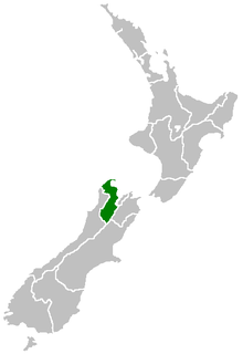
The Tasman Region is both a region
Regions of New Zealand
The region is the top tier of local government in New Zealand. There are 16 regions of New Zealand. Eleven are governed by an elected regional council, while five are governed by territorial authorities which also perform the functions of a regional council and thus are known as unitary authorities...
and a district
Districts of New Zealand
A district in New Zealand is a territorial authority area governed by a District Council as a second-tier local government unit. They were formed as a result of local government reforms in 1989.-Districts:There are currently 53 districts:*Ashburton District...
of New Zealand
New Zealand
New Zealand is an island country in the south-western Pacific Ocean comprising two main landmasses and numerous smaller islands. The country is situated some east of Australia across the Tasman Sea, and roughly south of the Pacific island nations of New Caledonia, Fiji, and Tonga...
. It borders with the West Coast Region
West Coast, New Zealand
The West Coast is one of the administrative regions of New Zealand, located on the west coast of the South Island, and is one of the more remote and most sparsely populated areas of the country. It is made up of three districts: Buller, Grey and Westland...
, Marlborough Region
Marlborough, New Zealand
Marlborough is one of the regions of New Zealand, located in the northeast of the South Island. Marlborough is a unitary authority, both a region and a district, and its council is located at Blenheim. Marlborough is known for its dry climate, the picturesque Marlborough Sounds, and sauvignon blanc...
and the Nelson Region
Nelson, New Zealand
Nelson is a city on the eastern shores of Tasman Bay, and is the economic and cultural centre of the Nelson-Tasman region. Established in 1841, it is the second oldest settled city in New Zealand and the oldest in the South Island....
. It is both a region and a unitary authority, and the District Council sits at Richmond
Richmond, New Zealand
Richmond, the seat of the Tasman District Council, lies 13 km south of Nelson in the South Island of New Zealand, close to the southern extremity of Tasman Bay...
, with Community Boards serving outlying communities in Motueka
Motueka
The town of Motueka in the South Island of New Zealand lies close to the mouth of the Motueka River, on the western shore of Tasman Bay. It is, after Nelson and Richmond, the third largest centre in the Tasman Region, with a population of 7125...
and Golden Bay
Golden Bay
Golden Bay lies at the edge of the junction between the Tasman Sea and Cook Strait. It stretches for 45 kilometres from the long sand spit of Farewell Spit in the north to Separation Point in Abel Tasman National Park at its southern extremity...
. Though the city of Nelson forms its own unitary region separate from the Tasman Region, the Tasman Region and Nelson are often grouped together by the public under a looser definition of the term "Tasman".
Geography
Tasman District is a large area at the top western side of the South Island of New Zealand. It covers 9,786 square kilometres and is bounded to the west by the Matiri Ranges, Tasman Mountains and the Tasman SeaTasman Sea
The Tasman Sea is the large body of water between Australia and New Zealand, approximately across. It extends 2,800 km from north to south. It is a south-western segment of the South Pacific Ocean. The sea was named after the Dutch explorer Abel Janszoon Tasman, the first recorded European...
. To the north Tasman
Tasman Bay
Tasman Bay is a large V-shaped bay at the north end of New Zealand's South Island. Located in the centre of the island's northern coast, it stretches along of coastline and is across at its widest point. It is an arm of the Tasman Sea, lying on the western approach to Cook Strait.At the bay's...
and Golden Bay
Golden Bay
Golden Bay lies at the edge of the junction between the Tasman Sea and Cook Strait. It stretches for 45 kilometres from the long sand spit of Farewell Spit in the north to Separation Point in Abel Tasman National Park at its southern extremity...
s form its seaward edge, and the eastern boundary extends to the edge of Nelson
Nelson, New Zealand
Nelson is a city on the eastern shores of Tasman Bay, and is the economic and cultural centre of the Nelson-Tasman region. Established in 1841, it is the second oldest settled city in New Zealand and the oldest in the South Island....
city, and includes part of the Spencer Mountains and the Saint Arnaud
Saint Arnaud Range
The Saint Arnaud Range is a mountain range in the central north of New Zealand's South Island. It lies between Lake Rotoiti and the upper reaches of the Wairau River, and marks the eastern boundary of Nelson Lakes National Park....
and Richmond Ranges. The Victoria Ranges form Tasman's southern boundary and the district's highest point is Mount Franklin, at 2,340 metres.
The landscape is diverse, from large mountainous areas to valleys and plains, and is sliced by such major rivers as the Buller River
Buller River
The Buller River is in the South Island of New Zealand. One of the country's longest rivers, it flows for 170 kilometres from Lake Rotoiti through the Buller Gorge and into the Tasman Sea near the town of Westport...
, Motueka
Motueka River
The Motueka River is located in the north of the South Island of New Zealand and is a popular tourist destination for watersports and fishing. The Motueka flows from the mountains 40 km west of the city of Nelson in the southeast of the catchment and flows north to the Tasman...
, Aorere
Aorere River
The Aorere River is in the South Island of New Zealand.The headwaters are within Kahurangi National Park. The river flows generally northwards for 40 kilometres, before draining into Golden Bay at the town of Collingwood....
, Takaka
Takaka River
The Takaka River lies in the northwest of New Zealand's South Island. It runs north for 70 kilometres, entering Golden Bay near the town of Takaka....
and Wairoa River
Wairoa River, Tasman
This Wairoa River is located in the north of the South Island of New Zealand. It flows north for 45 kilometres before combining with the Wai-iti River to form the Waimea River. This flows into the southern end of Tasman Bay near Richmond....
. The limestone
Limestone
Limestone is a sedimentary rock composed largely of the minerals calcite and aragonite, which are different crystal forms of calcium carbonate . Many limestones are composed from skeletal fragments of marine organisms such as coral or foraminifera....
-rich area around Mount Owen
Mount Owen, New Zealand
Mount Owen is in the Tasman district of the South Island of New Zealand. It stands at 1875 metres above sea level and is part of the Marino Mountains....
and Mount Arthur is notable for its extensive cave networks, among them New Zealand's deepest caves at Ellis Basin
Ellis Basin cave system
The Ellis Basin cave system is a group of interconnecting limestone caves located in the Mount Arthur region of the northwest South Island of New Zealand....
and Nettlebed
Nettlebed Cave
Nettlebed Cave is a limestone cave located in the Mount Arthur region of the northwest South Island of New Zealand.Until April 2010, when the nearby Ellis Basin cave system was found to be deeper, Nettlebed Cave was thought to be the deepest cave system in the southern hemisphere...
. There is lush bush and bird life, golden beaches, the unique 40 kilometre sands of Farewell Spit
Farewell Spit
Farewell Spit is a narrow sand spit situated at , at the northern end of the South Island of New Zealand. Known to the Māori as Tuhuroa, it runs eastwards from Cape Farewell, the island's northernmost point...
, and boundless fishing in the bays and rivers. These assets make the district irresistible to tourists and precious to those who live there.
Tasman is home to three national parks: Abel Tasman National Park
Abel Tasman National Park
Abel Tasman National Park is a national park located at the north end of the South Island of New Zealand. The park was founded in 1942, largely through the efforts of ornithologist and author Perrine Moncrieff to have land reserved for the purpose. With a coverage of only 225.3 square kilometres,...
(New Zealand's smallest at 225.41 km²), Nelson Lakes National Park
Nelson Lakes National Park
Nelson Lakes National Park is located in the South Island of New Zealand.It was formed in 1956 and covers some 1,020 km². It is centered at two large lakes, Rotoiti and Rotoroa. The park also includes surrounding valleys and mountain ranges...
(1,017.53 km²) and Kahurangi National Park
Kahurangi National Park
Kahurangi National Park is a national park in the northwest of the South Island of New Zealand. It was gazetted in 1996 and covers 4,520 km². It is the second largest of New Zealand's fourteen national parks...
(4,520 km²).
Economy
The sub-national GDP of the Tasman and Nelson regions was estimated at US$2.343 billion in 2003, 2% of New Zealand's national GDP.Name
Tasman BayTasman Bay
Tasman Bay is a large V-shaped bay at the north end of New Zealand's South Island. Located in the centre of the island's northern coast, it stretches along of coastline and is across at its widest point. It is an arm of the Tasman Sea, lying on the western approach to Cook Strait.At the bay's...
, the largest indentation in the north coast of the South Island
South Island
The South Island is the larger of the two major islands of New Zealand, the other being the more populous North Island. It is bordered to the north by Cook Strait, to the west by the Tasman Sea, to the south and east by the Pacific Ocean...
, was named after Abel Tasman
Abel Tasman
Abel Janszoon Tasman was a Dutch seafarer, explorer, and merchant, best known for his voyages of 1642 and 1644 in the service of the VOC . His was the first known European expedition to reach the islands of Van Diemen's Land and New Zealand and to sight the Fiji islands...
, the first reported European discoverer of New Zealand. It passed the name on to the adjoining district formed in 1989 largely from the merger of Waimea and Golden Bay counties.
Government and settlements
Tasman District CouncilTasman district council
Tasman District Council is the Territorial Local Authority for the Tasman District of New Zealand.-Mayor:The current mayor of Tasman is Richard Kempthorne, who previously served as a Richmond councillor for two terms before being elected Mayor in October 2007.-Councillors:Tasman elects its...
(unitary authority
Unitary authority
A unitary authority is a type of local authority that has a single tier and is responsible for all local government functions within its area or performs additional functions which elsewhere in the relevant country are usually performed by national government or a higher level of sub-national...
) headquarters are at Richmond
Richmond, New Zealand
Richmond, the seat of the Tasman District Council, lies 13 km south of Nelson in the South Island of New Zealand, close to the southern extremity of Tasman Bay...
, close to the adjoining Nelson City
Nelson, New Zealand
Nelson is a city on the eastern shores of Tasman Bay, and is the economic and cultural centre of the Nelson-Tasman region. Established in 1841, it is the second oldest settled city in New Zealand and the oldest in the South Island....
. Community Boards exist to serve outlying areas in Motueka
Motueka
The town of Motueka in the South Island of New Zealand lies close to the mouth of the Motueka River, on the western shore of Tasman Bay. It is, after Nelson and Richmond, the third largest centre in the Tasman Region, with a population of 7125...
and Golden Bay
Golden Bay
Golden Bay lies at the edge of the junction between the Tasman Sea and Cook Strait. It stretches for 45 kilometres from the long sand spit of Farewell Spit in the north to Separation Point in Abel Tasman National Park at its southern extremity...
. Other towns are Motueka
Motueka
The town of Motueka in the South Island of New Zealand lies close to the mouth of the Motueka River, on the western shore of Tasman Bay. It is, after Nelson and Richmond, the third largest centre in the Tasman Region, with a population of 7125...
, Brightwater
Brightwater
Brightwater is a town 20 kilometres southwest of Nelson in Tasman district in the South Island of New Zealand. It stands on the banks of the Wairoa River. Brightwater was named by Alfred Saunders, the owner of a local Flax mill situated on the banks of the Wairoa River, after a popular song at the...
, Collingwood
Collingwood, New Zealand
Collingwood is a town in the north-west corner of the South Island of New Zealand. It is located in the hub of the Aorere Valley, in the western half of the Golden Bay area.-Geography:The town lies at the end of State Highway 60 in Golden Bay...
, Murchison
Murchison, New Zealand
Murchison is a town in the Tasman Region of the South Island of New Zealand. It is near the western end of the "Four Rivers Plain", at the confluence of the Buller River and the Matakitaki River...
, Riwaka
Riwaka
Riwaka is a small town in the north of New Zealand's South Island. It lies beside Tasman Bay, five kilometres north of Motueka, and close to the mouth of the Riwaka River....
, Saint Arnaud
Saint Arnaud, New Zealand
Saint Arnaud is a small alpine village located in the north of New Zealand's South Island, west of the mountains of the Saint Arnaud Range and 90 kilometres southwest of Nelson near the historic Tophouse Settlement...
, Takaka, Tapawera
Tapawera
Tapawera is a small Kahurangi Gateway town in New Zealand's South Island. It is located 30 kilometres southwest of Nelson by the banks of the Motueka River...
, Wakefield
Wakefield, New Zealand
The small New Zealand community of Wakefield is situated some 25 km south west of Nelson at the top of the South Island.First settled in about 1843, it was originally called Pitfure. However the name was soon changed to Wakefield...
, Mapua
Mapua, New Zealand
Mapua is a small town in the South Island of New Zealand.It is to the west of Nelson on State Highway 60 and on the coastline of Tasman Bay. The 2006 census gave a population of 1878, up 16.1 percent since the 2001 Census.:...
, and Kaiteriteri
Kaiteriteri
Kaiteriteri is a town and seaside resort in the Tasman Region of the South Island of New Zealand. It is close to both Marahau, the main gateway to Abel Tasman National Park, and the township of Motueka.It is best known for its scenic beach.-External links:...
.
History
According to tradition, the Māori waka Uruao, brought ancestors of the WaitahaWaitaha
Waitaha is an early historical Māori iwi . Inhabitants of the South Island of New Zealand, they were largely absorbed via marriage and conquest first by the Kāti Mamoe and then Ngāi Tahu from the 16th century onward....
people to Tasman in the 12th Century. Archaeological evidence suggests the first Māori settlers explored the region thoroughly, settling mainly along the coast where there was ample food.
The succession of tribes into the area suggests considerable warfare interrupted their lives. Around 1828, Ngati Toa
Ngati Toa
Ngāti Toa , an iwi , traces its descent from the eponymous ancestor Toarangatira. The Ngāti Toa region extends from Miria-te-kakara at Rangitikei to Wellington, and across Cook Strait to Wairau and Nelson....
under Te Rauparaha
Te Rauparaha
Te Rauparaha was a Māori rangatira and war leader of the Ngāti Toa tribe who took a leading part in the Musket Wars. He was influential in the original sale of conquered Rangitane land to the New Zealand Company and was a participant in the Wairau Incident in Marlborough...
and the allied northern tribes of Ngati Rarua and Ngati Tama, started their invasion of the South Island
South Island
The South Island is the larger of the two major islands of New Zealand, the other being the more populous North Island. It is bordered to the north by Cook Strait, to the west by the Tasman Sea, to the south and east by the Pacific Ocean...
. They took over much of the area from Farewell Spit
Farewell Spit
Farewell Spit is a narrow sand spit situated at , at the northern end of the South Island of New Zealand. Known to the Māori as Tuhuroa, it runs eastwards from Cape Farewell, the island's northernmost point...
to the Wairau River
Wairau River
The Wairau River is one of the longest rivers in New Zealand's South Island. It flows for 170 kilometres from the Spenser Mountains , firstly in a northwards direction and then northeast down a long, straight valley in inland Marlborough.The river's lower reaches are noted for the surrounding...
.
The first immigrant ships from England arrived in 1842 and the European settlement of the region began under the leadership of Captain Arthur Wakefield
Arthur Wakefield
Captain Arthur Wakefield served with the Royal Navy, before joining his brother, Edward Gibbon Wakefield, in founding the new settlement at Nelson, New Zealand.-Royal Navy:...
.
In the 1850s, agriculture and pastoral farming started and villages were established on the Waimea Plains
Waimea Plains
The Waimea Plains is the name of two areas of land at opposite ends of the South Island of New Zealand.-Waimea Plains, Tasman:The northern area with this name is a small but fertile area of low-lying land south of the city of Nelson...
and Motueka. In 1856, the discovery of gold near Collingwood
Collingwood, New Zealand
Collingwood is a town in the north-west corner of the South Island of New Zealand. It is located in the hub of the Aorere Valley, in the western half of the Golden Bay area.-Geography:The town lies at the end of State Highway 60 in Golden Bay...
sparked New Zealand
New Zealand
New Zealand is an island country in the south-western Pacific Ocean comprising two main landmasses and numerous smaller islands. The country is situated some east of Australia across the Tasman Sea, and roughly south of the Pacific island nations of New Caledonia, Fiji, and Tonga...
's first gold rush. Significant reserves of iron ore were located at Onekaka
Onekaka
Onekaka is a small coastal community in Golden Bay, at the northwestern tip of the South Island, New Zealand with a population of around 250.The name Onekaka is Māori and translated as 'burning sands'....
and an iron works operated here during the 1920s and 1930s.
Fruit growing started at the end of the 19th Century. By 1945, it was making a significant contribution to the local economy and that importance continues today.
People
Most of Tasman's urban population lives in the Richmond
Richmond, New Zealand
Richmond, the seat of the Tasman District Council, lies 13 km south of Nelson in the South Island of New Zealand, close to the southern extremity of Tasman Bay...
Ward (10,851). It has the district's fastest growth rate, particularly in North Richmond where the population has grown by 23% since 1996.
The second largest area of growth is in the Waimea
Waimea Plains
The Waimea Plains is the name of two areas of land at opposite ends of the South Island of New Zealand.-Waimea Plains, Tasman:The northern area with this name is a small but fertile area of low-lying land south of the city of Nelson...
/Moutere Ward. Mapua has posted the highest growth - 27.4% between 1996 and 2001.
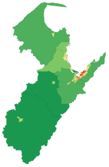
Although Tasman has recorded strong growth, the region has a low population density. As at March 2001, there were an estimated 4.3 people per square kilometre. This is mainly due to the lack of large urban areas and 58% of the area constituting lands covered by national parks.
People of European ancestry make up 82.7% of the Tasman population, significantly higher than the 67.6% for New Zealand overall.
The number of Māori, European, Pacific Island and Asians have increased markedly since 1991, with Māori increasing by 60.5%. The main iwi represented in the wider Tasman region are Ngati Rarua, Ngati Tama (Golden Bay
Golden Bay
Golden Bay lies at the edge of the junction between the Tasman Sea and Cook Strait. It stretches for 45 kilometres from the long sand spit of Farewell Spit in the north to Separation Point in Abel Tasman National Park at its southern extremity...
and Tasman Bay
Tasman Bay
Tasman Bay is a large V-shaped bay at the north end of New Zealand's South Island. Located in the centre of the island's northern coast, it stretches along of coastline and is across at its widest point. It is an arm of the Tasman Sea, lying on the western approach to Cook Strait.At the bay's...
), Te Atiawa, Ngati Koata, Ngati Kuia (eastern Tasman Bay
Tasman Bay
Tasman Bay is a large V-shaped bay at the north end of New Zealand's South Island. Located in the centre of the island's northern coast, it stretches along of coastline and is across at its widest point. It is an arm of the Tasman Sea, lying on the western approach to Cook Strait.At the bay's...
) and the Poutini Ngai Tahu
Ngai Tahu
Ngāi Tahu, or Kāi Tahu, is the principal Māori iwi of the southern region of New Zealand, with the tribal authority, Te Rūnanga o Ngāi Tahu, being based in Christchurch and Invercargill. The iwi combines three groups, Kāi Tahu itself, and Waitaha and Kāti Mamoe who lived in the South Island prior...
(southern areas).
Famous former residents include nuclear physicist Ernest Rutherford
Ernest Rutherford
Ernest Rutherford, 1st Baron Rutherford of Nelson OM, FRS was a New Zealand-born British chemist and physicist who became known as the father of nuclear physics...
, former Prime Ministers Bill Rowling
Bill Rowling
Sir Wallace Edward Rowling, KCMG , often known as Bill Rowling, was the 30th Prime Minister of New Zealand. He was in office for just over a year, having been appointed Prime Minister following the death of the highly popular Norman Kirk...
and Sir Keith Holyoake
Keith Holyoake
Sir Keith Jacka Holyoake, KG, GCMG, CH, QSO, KStJ was a New Zealand politician. The only person to have been both Prime Minister and Governor-General of New Zealand, Holyoake was National Party Prime Minister from 20 September 1957 to 12 December 1957, then again from 12 December 1960 to 7...
, and Sir Michael Myers
Michael Myers (judge)
Sir Michael Myers, GCMG, KC, PC, was the sixth Chief Justice of the Supreme Court of New Zealand from 1929 to 1946 and served occasionally as Administrator of New Zealand from 1930 to 1941. He was the first person of Jewish descent to hold this position...
, Chief Justice of New Zealand 1929-1946.