
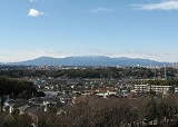
Tanzawa
Encyclopedia
Kanto region
The is a geographical area of Honshu, the largest island of Japan. The region includes the Greater Tokyo Area and encompasses seven prefectures: Gunma, Tochigi, Ibaraki, Saitama, Tokyo, Chiba, and Kanagawa. Within its boundaries, slightly more than 40 percent of the land area is the Kantō Plain....
, in Japan
Japan
Japan is an island nation in East Asia. Located in the Pacific Ocean, it lies to the east of the Sea of Japan, China, North Korea, South Korea and Russia, stretching from the Sea of Okhotsk in the north to the East China Sea and Taiwan in the south...
. It covers the northwestern part of Kanagawa Prefecture
Kanagawa Prefecture
is a prefecture located in the southern Kantō region of Japan. The capital is Yokohama. Kanagawa is part of the Greater Tokyo Area.-History:The prefecture has some archaeological sites going back to the Jōmon period...
and touches the prefectural borders of Shizuoka Prefecture
Shizuoka Prefecture
is a prefecture of Japan located in the Chūbu region on Honshu island. The capital is the city of Shizuoka.- History :Shizuoka prefecture was formed from the former Tōtōmi, Suruga and Izu provinces.The area was the home of the first Tokugawa Shogun...
to the west and the Yamanashi Prefecture
Yamanashi Prefecture
is a prefecture of Japan located in the Chūbu region of the island of Honshū. The capital is the city of Kōfu.-Pre-history to the 14th century:People have been living in the Yamanashi area for about 30,000 years...
to the north.
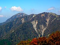
Mountains
- Mount HiruMount HiruMount Hiru is the tallest mountain of the Tanzawa Mountains with a height of ....
1,673m (蛭ヶ岳 Hiru-ga-take) - Mount Fudō 1,614m (不動ノ峰 Fudō-no-mine)
- Mount Hinokiboramaru 1,601m (檜洞丸 Hinokibora-maru)
- Mount TanzawaMount Tanzawais a mountain of the Tanzawa Mountains, with an elevation of . Its summit marks the border between Sagamihara, Kiyokawa in Aikō District, and Yamakita in Ashigarakami District.-References:*...
1,567m (丹沢山 Tanzawa-san) - Mount TōMount Tois a mountain of Tanzawa Mountains, located on the border of Kiyokawa, Hadano and Yamakita in Kanagawa, Japan.- Outline :Mount Tō is one of the most popular mountains in Tanzawa Mountains. This mountain is a part of Tanzawa-Ōyama Quasi-National Park with other Tanzawa Mountains.-References:* * *...
1,491m (塔ノ岳 Tō-no-dake) - Mount ShindainichiMount Shindainichiis a peak of the Tanzawa Mountains with an elevation of , and is located due east of Mount Tō. It is located within the boundary of the Tanzawa-Ōyama Quasi-National Park....
1,340m (新大日 Shin-dainichi) - Mount ŌyamaMount Oyama (Kanagawa), also or Mount Kunimi , is a high mountain situated on the border of Isehara, Hadano and Atsugi in Kanagawa Prefecture, Japan. Together with Mount Tanzawa and other mountains in the Tanzawa Mountains it forms the Tanzawa-Ōyama Quasi-National Park...
1,252m (大山 Ō-yama)
Hiking
Climbers come from various parts of Japan, but there have been a growing number of international climbers. The mountain range offers numerous moderate to strenuous trails for hikers. The most popular peaksMountain
Image:Himalaya_annotated.jpg|thumb|right|The Himalayan mountain range with Mount Everestrect 58 14 160 49 Chomo Lonzorect 200 28 335 52 Makalurect 378 24 566 45 Mount Everestrect 188 581 920 656 Tibetan Plateaurect 250 406 340 427 Rong River...
among climbers are Mount Tō
Mount To
is a mountain of Tanzawa Mountains, located on the border of Kiyokawa, Hadano and Yamakita in Kanagawa, Japan.- Outline :Mount Tō is one of the most popular mountains in Tanzawa Mountains. This mountain is a part of Tanzawa-Ōyama Quasi-National Park with other Tanzawa Mountains.-References:* * *...
(塔ノ岳) and Mount Ōyama
Mount Oyama (Kanagawa)
, also or Mount Kunimi , is a high mountain situated on the border of Isehara, Hadano and Atsugi in Kanagawa Prefecture, Japan. Together with Mount Tanzawa and other mountains in the Tanzawa Mountains it forms the Tanzawa-Ōyama Quasi-National Park...
(大山) which are located in the eastern part of the Mountains, mainly due to their easier transportation access from Yabitsu Pass. However, the tallest mountain in these mountains is Mount Hiru
Mount Hiru
Mount Hiru is the tallest mountain of the Tanzawa Mountains with a height of ....
, which is 1673 metres (5,489 ft). In comparison, Mount Tō is 1,491m (4,891ft) high and Mount Ōyama is 1252 metres (4,108 ft) high. The western part is less often visited, but offers the opportunity of river trekking
River trekking
River climbing, river trekking or mountain stream climbing is a form of hiking or outdoor adventure activity, a traditional sport in Japan and popular in Hong Kong and Taiwan, and, in some ways, similar to canyoning or canyoneering. River trekking is a combination of trekking and climbing and...
or sawanobori
Sawanobori
, or river climbing, is a type of mountaineering that involves going up mountain streams to their source that is popular in Japan.-Description:The sport consists of ascending a tributary of a river along with its features, including climbing waterfalls, traversing ravine walls, and swimming through...
(a form of mountaineering
Mountaineering
Mountaineering or mountain climbing is the sport, hobby or profession of hiking, skiing, and climbing mountains. While mountaineering began as attempts to reach the highest point of unclimbed mountains it has branched into specialisations that address different aspects of the mountain and consists...
).
Fishing
Fishing is another popular activity within the rivers of Tanzawa. Different types of fish can be caught such as trout and yamame.Sites
The Tanzawa Mountains are most accessible by Kanagawa Route 70, which runs between HadanoHadano, Kanagawa
is a city in west-central Kanagawa Prefecture, Japan. As of February 2010, Hadano has an estimated population of 170,293 and a population density of 1,640 persons per km²; it had a total area of 103.61 km².-Geography:...
and Miyagase. The highest point of the route is Yabitsu Pass, approximately 11 km from Hadano. Towards the middle of the route is Kiyokawa Village
Kiyokawa, Kanagawa
is a village located in Aikō District, Kanagawa, Japan. As of 2010, the village had an estimated population of 3,556and a density of 49.9 persons per km². The total area is 71.29 km².-Geography:...
, which offers lodging, camping, and fishing, and also has a trailhead for hiking the different mountains. Various other campsites can be found along Route 70. Another place of interest is Lake Miyagase
Lake Miyagase
Lake Miyagase is a lake within the Aiko District of Kanagawa, Japan, located between Sagamihara and Atsugi. The lake offers views of Tanzawa Mountains, including Mount Hiru. The lake is a man-made reservoir and formed by the Miyagase Dam, and is a source of drinking water for Yokohama and Tokyo....
, which is man-made and filled with a dam.
Wildlife and flora
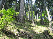
Pinophyta
The conifers, division Pinophyta, also known as division Coniferophyta or Coniferae, are one of 13 or 14 division level taxa within the Kingdom Plantae. Pinophytes are gymnosperms. They are cone-bearing seed plants with vascular tissue; all extant conifers are woody plants, the great majority being...
and the other half deciduous
Deciduous
Deciduous means "falling off at maturity" or "tending to fall off", and is typically used in reference to trees or shrubs that lose their leaves seasonally, and to the shedding of other plant structures such as petals after flowering or fruit when ripe...
. The coniferous trees include Japanese cedar (杉) and Hinoki cypress (檜), and are mainly seen in the lower altitudes near the valleys. The deciduous trees include Japanese mountain maple (山紅葉) and Japanese beech
Fagus crenata
Fagus crenata, known as the Japanese beech, Siebold's beech, or buna, is a deciduous tree of the beech family Fagaceae. It is native to Japan where it is widespread and often one of the dominant trees of Japan's deciduous forests. It is found from the Oshima Peninsula in Hokkaidō south to the Ōsumi...
, and are more common in the higher altitudes. Various types of flowers can be found throughout the year, such as Rhododendron
Rhododendron
Rhododendron is a genus of over 1 000 species of woody plants in the heath family, most with showy flowers...
.
The area is populated with Sika Deer (鹿), Japanese racoon dog (狸)
Tanuki
is the common Japanese name for the Japanese raccoon dog . They have been part of Japanese folklore since ancient times...
, Japanese flying squirrel
Japanese Giant Flying Squirrel
The is a type of flying squirrel. Like other flying squirrels it has a web of skin between its legs which it uses to glide between trees. Glides of 160 metres have been recorded. The tail is used for stability during flight. The body is about 25–50cm long, and the tail a further...
and Japanese Serow
Japanese Serow
The Japanese serow , known in Japanese as the , is a goat-antelope found in dense woodland on Honshū, Japan....
. There are also hundreds of species of birds such as Kingfisher
Kingfisher
Kingfishers are a group of small to medium sized brightly coloured birds in the order Coraciiformes. They have a cosmopolitan distribution, with most species being found in the Old World and Australia...
. Along the river banks, frogs and lizards can be commonly found.