
Talsi District
Encyclopedia
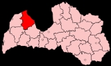
Talsi District was an administrative division
of Latvia
, located in Courland
region, in the country's west. It was one of the former 26 rural districts of Latvia and it consisted of 20 local communities.
These included three towns:
Talsi District was located in the northern part of Courland
. It bordered the districts of Ventspils
, Kuldiga
and Tukums
. It was surrounded by the 96 km long shoreline of the Gulf of Riga
and the Irbe Strait
.
The district covered 2751 square kilometres (1,062.2 sq mi), or 4.1% of the whole territory of Latvia. Woodland covered 55% of Talsi district's territory, 29% was agricultural land, 3.5% was water, and 3.4% (9,400 ha; 23,200 ac) were swamps, of which peat
production covered 1,700 ha (4,200 ac).
The highest point in Talsi is Kamparkalns (174 m or 571 ft above sea level) at Talsi Hillock.
The total population was 49,842 people, or 2.1% of the entire population of Latvia. Nationalities included Latvians
- 92%, Russians
- 4%, others (Gypsies, Belarusians
and Ukrainians
) - 4%. Population density was 18 people per square km, compared to the national density of 38 people per square km. 63.5% of the population was urban, and 36.5% was rural.
Districts were eliminated during the administrative-territorial reform in 2009.
Districts of Latvia
||Before July 1, 2009 Latvia was divided into 26 districts and 7 cities , indicated with asterisks:...
of Latvia
Latvia
Latvia , officially the Republic of Latvia , is a country in the Baltic region of Northern Europe. It is bordered to the north by Estonia , to the south by Lithuania , to the east by the Russian Federation , to the southeast by Belarus and shares maritime borders to the west with Sweden...
, located in Courland
Courland
Courland is one of the historical and cultural regions of Latvia. The regions of Semigallia and Selonia are sometimes considered as part of Courland.- Geography and climate :...
region, in the country's west. It was one of the former 26 rural districts of Latvia and it consisted of 20 local communities.
These included three towns:
- TalsiTalsiTalsi is a town in Latvia. It is the center of Talsi municipality.-Talsi:Talsi - known as 'The Town of Nine Hills' - perches above two lakes...
(12,391 inhabitants) - the center of the district - ValdemārpilsValdemarpilsValdemārpils is a town in northwestern Latvia, near Talsi. The town is named after Krišjānis Valdemārs, born in nearby Ārlava parish, who was one of the leaders of the first Latvian National Awakening. He is celebrated in the town with a memorial stone.-References:...
town with its rural territory - StendeStende-See also:*List of cities in Latvia...
town - one region - SabileSabileSabile is a town in Talsi municipality, Latvia.Sabile was first mentioned in chronicles in 1253. From the 14th century to the 16th century, it was a site of a castle of the Livonian Order and a village near the castle. Sabilė became a town in 1917....
Region, including Sabile Town; - 16 rural municipalities (pagasts): KolkaKolkathumb|Former Orthodox seminary and church in the backgroundKolka is a village in Kolka parish, Dundaga municipality on the tip of Cape Kolka in Courland in Latvia, on the coast of the Gulf of Riga in ancient Livonia. It is home to the last remnants of Latvia's Livonian ethnic group, whose Livonian...
, Roja, MērsragsMersragsThe rural municipality of Mērsrags is located on the west coast of the Gulf of Riga , beside Lake Engure and surrounded by extensive woodlands. It’s situated in northwest Latvia in wooded lowland close the sea. It is in the district of Talsi, which includes the townships of Kulciems, Lauciena,...
, DundagaDundagaDundaga is a village in Courland, Latvia. From 2009 its an administrative centre of Dundaga municipality.Dundaga is famous for its castle from late 13th century, constructed by Archbishopric of Riga. From the 16th until the 20th century, Dundaga Castle was the centre of the largest private estate...
, Balgale, Gibuli, IveIveIve or IVE may refer to:* Ive, former name of Ivesta, California* Ive, Latvia, rural municipality in Talsi District, Latvia* Instrumental variable estimation, a statistical analysis method...
, Kulciems, Laidze, Lauciene, Libagi, LubeLubeLube may refer to:*Lubricant, a substance introduced between two moving surfaces to reduce the friction and wear between them**Personal lubricant, referring to lubricant used in sex acts...
, Strazde, ValdgaleValdgaleValdgale parish is situated in the Talsi District of Latvia. It is located approximately 13 km from the city of Talsi, 4 km from Valdemārpils and 20 km from Dundaga. The centre of Valdgale parish is called Punas, from where it is about 5 km to the birthplace of the renowned...
, VandzeneVandzeneVandzene is a village in Vandzene parish, Talsi District, in the western part of Latvia. The community's elevation is 49 m .The Vandzene Estate was built at the start of the 19th century. At present, Vandzene Gymnasium occupies the estate....
and Virbi.
Talsi District was located in the northern part of Courland
Courland
Courland is one of the historical and cultural regions of Latvia. The regions of Semigallia and Selonia are sometimes considered as part of Courland.- Geography and climate :...
. It bordered the districts of Ventspils
Ventspils District
The Ventspils District was an administrative division of Latvia, located in the Courland region, in the country's west.The district consisted of 11 parishes - Ance, Jūrkalne, Pope, Puze, Targale, Ugale, Usma, Uzava, Varve, Ziras, Zlekas parish and Piltene town's rural territory.Districts were...
, Kuldiga
Kuldiga District
Kuldīga District was an administrative division of Latvia, located in Courland region, in the country's west. It was organized into a city and thirteen parishes, each with a local government authority. The main city in the district was Kuldīga....
and Tukums
Tukums District
Tukums District was an administrative division of Latvia, located in Courland region, in the country's west.Districts were eliminated during the administrative-territorial reform in 2009....
. It was surrounded by the 96 km long shoreline of the Gulf of Riga
Gulf of Riga
The Gulf of Riga, or Bay of Riga, is a bay of the Baltic Sea between Latvia and Estonia. According to C.Michael Hogan, a saline stratification layer is found at a depth of approximately seventy metres....
and the Irbe Strait
Irbe Strait
Irbe Strait, also known as Irben Strait , forms the main exit out of the Gulf of Riga to the Baltic Sea, between the Sõrve Peninsula forming the southern end of the island Saaremaa in Estonia and Courland peninsula in Latvia. It is 27 km wide at its narrowest point...
.
The district covered 2751 square kilometres (1,062.2 sq mi), or 4.1% of the whole territory of Latvia. Woodland covered 55% of Talsi district's territory, 29% was agricultural land, 3.5% was water, and 3.4% (9,400 ha; 23,200 ac) were swamps, of which peat
Peat
Peat is an accumulation of partially decayed vegetation matter or histosol. Peat forms in wetland bogs, moors, muskegs, pocosins, mires, and peat swamp forests. Peat is harvested as an important source of fuel in certain parts of the world...
production covered 1,700 ha (4,200 ac).
The highest point in Talsi is Kamparkalns (174 m or 571 ft above sea level) at Talsi Hillock.
The total population was 49,842 people, or 2.1% of the entire population of Latvia. Nationalities included Latvians
Latvians
Latvians or Letts are the indigenous Baltic people of Latvia.-History:Latvians occasionally refer to themselves by the ancient name of Latvji, which may have originated from the word Latve which is a name of the river that presumably flowed through what is now eastern Latvia...
- 92%, Russians
Russians
The Russian people are an East Slavic ethnic group native to Russia, speaking the Russian language and primarily living in Russia and neighboring countries....
- 4%, others (Gypsies, Belarusians
Belarusians
Belarusians ; are an East Slavic ethnic group who populate the majority of the Republic of Belarus. Introduced to the world as a new state in the early 1990s, the Republic of Belarus brought with it the notion of a re-emerging Belarusian ethnicity, drawn upon the lines of the Old Belarusian...
and Ukrainians
Ukrainians
Ukrainians are an East Slavic ethnic group native to Ukraine, which is the sixth-largest nation in Europe. The Constitution of Ukraine applies the term 'Ukrainians' to all its citizens...
) - 4%. Population density was 18 people per square km, compared to the national density of 38 people per square km. 63.5% of the population was urban, and 36.5% was rural.
Districts were eliminated during the administrative-territorial reform in 2009.