
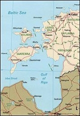
Gulf of Riga
Encyclopedia
The Gulf of Riga, or Bay of Riga, ' onMouseout='HidePop("86512")' href="/topics/Livonia">Livonia
, , both meaning the Riga Bay or the Riga Gulf) is a bay
of the Baltic Sea
between Latvia
and Estonia
. According to C.Michael Hogan, a saline stratification layer is found at a depth of approximately seventy metres.
The area of the Gulf of Riga is about 18,000 km². The maximum depth is 67 m.
The island of Saaremaa
(Estonia) partially separates it from the rest of the Baltic Sea. The main exit out of the gulf is the Irbe Strait
.
Ruhnu
island, in the middle of the gulf, also belongs to Estonia
.
Notable cities in this gulf include Riga
, Pärnu
, Jūrmala
and Kuressaare
. The main rivers flowing into the gulf are Daugava, Pärnu
, Lielupe
, Gauja
, and Salaca
.
The International Hydrographic Organization
defines its limits as a line running from Ovīši [Lyser Ort] (57°34'N) in Latvia to the south extreme of Saaremaa
[Ösel], through Saaremaa to Pammana Point [Pammerort] (22°34'E), thence to Emmaste Point, the south extreme of Hiiumaa
[Dagö], through Hiiumaa to Tahkuna Point, the northern extreme of the island, and on to Cape Põõsaspea [Spithamn Point] in mainland Estonia.
Livonia
Livonia is a historic region along the eastern shores of the Baltic Sea. It was once the land of the Finnic Livonians inhabiting the principal ancient Livonian County Metsepole with its center at Turaida...
, , both meaning the Riga Bay or the Riga Gulf) is a bay
Headlands and bays
Headlands and bays are two related features of the coastal environment.- Geology and geography :Headlands and bays are often found on the same coastline. A bay is surrounded by land on three sides, whereas a headland is surrounded by water on three sides. Headlands are characterized by high,...
of the Baltic Sea
Baltic Sea
The Baltic Sea is a brackish mediterranean sea located in Northern Europe, from 53°N to 66°N latitude and from 20°E to 26°E longitude. It is bounded by the Scandinavian Peninsula, the mainland of Europe, and the Danish islands. It drains into the Kattegat by way of the Øresund, the Great Belt and...
between Latvia
Latvia
Latvia , officially the Republic of Latvia , is a country in the Baltic region of Northern Europe. It is bordered to the north by Estonia , to the south by Lithuania , to the east by the Russian Federation , to the southeast by Belarus and shares maritime borders to the west with Sweden...
and Estonia
Estonia
Estonia , officially the Republic of Estonia , is a state in the Baltic region of Northern Europe. It is bordered to the north by the Gulf of Finland, to the west by the Baltic Sea, to the south by Latvia , and to the east by Lake Peipsi and the Russian Federation . Across the Baltic Sea lies...
. According to C.Michael Hogan, a saline stratification layer is found at a depth of approximately seventy metres.
The area of the Gulf of Riga is about 18,000 km². The maximum depth is 67 m.
The island of Saaremaa
Saaremaa
Saaremaa is the largest island in Estonia, measuring 2,673 km². The main island of Saare County, it is located in the Baltic Sea, south of Hiiumaa island, and belongs to the West Estonian Archipelago...
(Estonia) partially separates it from the rest of the Baltic Sea. The main exit out of the gulf is the Irbe Strait
Irbe Strait
Irbe Strait, also known as Irben Strait , forms the main exit out of the Gulf of Riga to the Baltic Sea, between the Sõrve Peninsula forming the southern end of the island Saaremaa in Estonia and Courland peninsula in Latvia. It is 27 km wide at its narrowest point...
.
Ruhnu
Ruhnu
Ruhnu is an island situated in the Gulf of Riga in the Baltic Sea. It belongs to Estonia and is an administrative part of Saare County. At 11.9 km2 it has currently less than 100, mostly ethnic Estonian permanent inhabitants...
island, in the middle of the gulf, also belongs to Estonia
Estonia
Estonia , officially the Republic of Estonia , is a state in the Baltic region of Northern Europe. It is bordered to the north by the Gulf of Finland, to the west by the Baltic Sea, to the south by Latvia , and to the east by Lake Peipsi and the Russian Federation . Across the Baltic Sea lies...
.
Notable cities in this gulf include Riga
Riga
Riga is the capital and largest city of Latvia. With 702,891 inhabitants Riga is the largest city of the Baltic states, one of the largest cities in Northern Europe and home to more than one third of Latvia's population. The city is an important seaport and a major industrial, commercial,...
, Pärnu
Pärnu
Pärnu is a city in southwestern Estonia on the coast of Pärnu Bay, an inlet of the Gulf of Riga in the Baltic Sea. It is a popular summer vacation resort with many hotels, restaurants, and large beaches. The Pärnu River flows through the city and drains into the Gulf of Riga...
, Jūrmala
Jurmala
Jūrmala is a city in Latvia, about 25 kilometers west of Riga. Jūrmala is a resort town stretching and sandwiched between the Gulf of Riga and the Lielupe River...
and Kuressaare
Kuressaare
Kuressaare is a town and a municipality on Saaremaa island in Estonia. It is the capital of Saare County. The current population is about 14,706 Kuressaare is a town and a municipality on Saaremaa island in Estonia. It is the capital of Saare County. The current population is about 14,706...
. The main rivers flowing into the gulf are Daugava, Pärnu
Pärnu River
The Pärnu is a river in Estonia that drains into the Gulf of Riga at Pärnu. It is a one of the longest rivers in Estonia - 144 km long. It has the basin area of 6,920 km² and average discharge is 64.4 m³/s.- References :...
, Lielupe
Lielupe
The Lielupe is a river in central Latvia. Its length is 119 km . The surface area of its basin is 17,600 km²...
, Gauja
Gauja
The Gauja is one of the longest rivers in Latvia, with a length of and a catchment area of . Its source is in the hills southeast of Cēsis. It first flows east and north and forms the border with Estonia for about . South of Valga and Valka, it turns west towards Valmiera, continuing southwest...
, and Salaca
Salaca
The Salaca is a river in northern Latvia. It flows from Lake Burtnieks in Vidzeme, 90 km, to the Gulf of Riga. The river flows through three towns, Mazsalaca, Staicele and Salacgrīva. The riverbanks feature Devonian red sandstone cliffs, and many caves and rapids as well. The Salaca is one of...
.
Extent
The Gulf of Riga as a sub-basin of the Baltic also includes the Väinameri Sea in the West Estonian archipelago.The International Hydrographic Organization
International Hydrographic Organization
The International Hydrographic Organization is the inter-governmental organisation representing the hydrographic community. It enjoys observer status at the UN and is the recognised competent authority on hydrographic surveying and nautical charting...
defines its limits as a line running from Ovīši [Lyser Ort] (57°34'N) in Latvia to the south extreme of Saaremaa
Saaremaa
Saaremaa is the largest island in Estonia, measuring 2,673 km². The main island of Saare County, it is located in the Baltic Sea, south of Hiiumaa island, and belongs to the West Estonian Archipelago...
[Ösel], through Saaremaa to Pammana Point [Pammerort] (22°34'E), thence to Emmaste Point, the south extreme of Hiiumaa
Hiiumaa
Hiiumaa is the second largest island belonging to Estonia. It is located in the Baltic Sea, north of the island of Saaremaa, a part of the West Estonian archipelago. Its largest town is Kärdla.-Name:...
[Dagö], through Hiiumaa to Tahkuna Point, the northern extreme of the island, and on to Cape Põõsaspea [Spithamn Point] in mainland Estonia.