

Talimena Scenic Drive
Encyclopedia
National Scenic Byway
A National Scenic Byway is a road recognized by the United States Department of Transportation for its archeological, cultural, historic, natural, recreational, and/or scenic qualities. The program was established by Congress in 1991 to preserve and protect the nation's scenic but often...
in southeastern Oklahoma
Kiamichi country
Southeastern Oklahoma, also known by its official tourism designation, Kiamichi Country, encompasses the southeastern quarter of the state of Oklahoma. The term "Kiamichi Country" was coined by the Oklahoma Department of Tourism and Recreation as one of six travel destination regions within the...
and extreme western Arkansas
Arkansas
Arkansas is a state located in the southern region of the United States. Its name is an Algonquian name of the Quapaw Indians. Arkansas shares borders with six states , and its eastern border is largely defined by the Mississippi River...
spanning a 54 miles (86.9 km) stretch of Oklahoma State Highway 1 (SH-1) and Arkansas Highway 88 (Hwy 88) from Talihina, Oklahoma
Talihina, Oklahoma
Talihina is a town in Le Flore County, Oklahoma, United States, its name originating from two Choctaw words, tully and hena, meaning iron road. Iron road is reference to the railroad that the town was built around. It is part of the Fort Smith, Arkansas-Oklahoma Metropolitan Statistical Area...
, to Mena, Arkansas
Mena, Arkansas
Mena is a city in Polk County, Arkansas, United States. It is also the county seat of Polk County.It was founded by Arthur Edward Stilwell during the building of the Kansas City, Pittsburg and Gulf Railroad . It was Stilwell who decided Mena would be the name of this new town along the route to...
.
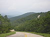
Route description
Designated a National Scenic Byway by the America's Byway Program in 2005, the road travels within the Ouachita National ForestOuachita National Forest
The Ouachita National Forest is a National Forest that lies in the western portion of Arkansas and portions of eastern Oklahoma.-History:The Ouachita National Forest is the oldest National Forest in the southern United States. The Forest encompasses , including most of the scenic Ouachita Mountains...
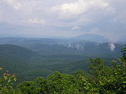
along the highest peaks of the Winding Stair Mountains, part of the Ouachita Mountain chain
Ouachita Mountains
The Ouachita Mountains are a mountain range in west central Arkansas and southeastern Oklahoma. The range's subterranean roots may extend as far as central Texas, or beyond it to the current location of the Marathon Uplift. Along with the Ozark Mountains, the Ouachita Mountains form the U.S...
, including the second tallest peak in Arkansas, Rich Mountain. Many of the forests along these ridges, stunted and of little commercial value, were never logged and are old growth. The two-lane road features hiking trails beginning at various points along its stretch and 22 scenic vista pull-outs. There are at least 13% hill grades along the route.
History
The current route opened in 1969 and formed a stretch of what would become Oklahoma State Highway 1. In this case, the number 1 was assigned due to the scenery along the highway. It was dedicated on June 7, 1970 by Lucy Baines Johnson-Nugent, the daughter of U.S. president Lyndon B. JohnsonLyndon B. Johnson
Lyndon Baines Johnson , often referred to as LBJ, was the 36th President of the United States after his service as the 37th Vice President of the United States...
.
The roadway was designated as a National Forest Scenic Byway on February 8, 1989. It was later made an Arkansas State Scenic Byway on January 7, 1998, and an Oklahoma State Scenic Byway on October 10, 2002. The National Scenic Byway status was conferred on September 22, 2005.