
Kiamichi country
Encyclopedia
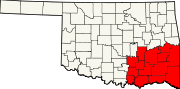
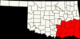
Oklahoma
Oklahoma is a state located in the South Central region of the United States of America. With an estimated 3,751,351 residents as of the 2010 census and a land area of 68,667 square miles , Oklahoma is the 28th most populous and 20th-largest state...
. The term "Kiamichi Country" was coined by the Oklahoma Department of Tourism and Recreation as one of six travel destination regions within the state and is named after the Kiamichi River
Kiamichi River
The Kiamichi River is a river in southeastern Oklahoma. A tributary of the Red River, its headwaters rise on Pine Mountain in the Ouachita Mountains near the Arkansas border...
and Kiamichi Mountains
Kiamichi Mountains
The Kiamichi Mountains are a mountain range in southeastern Oklahoma. A subrange within the larger Ouachita Mountains that extend from Oklahoma to western Arkansas, the Kiamichi Mountains sit within Le Flore, Pushmataha, and McCurtain counties near the towns of Poteau and Albion...
. Due to an influx of southerners seeking less expensive frontier lands during the post-Civil War
American Civil War
The American Civil War was a civil war fought in the United States of America. In response to the election of Abraham Lincoln as President of the United States, 11 southern slave states declared their secession from the United States and formed the Confederate States of America ; the other 25...
Reconstruction era, Kiamichi Country is more southern
Southern United States
The Southern United States—commonly referred to as the American South, Dixie, or simply the South—constitutes a large distinctive area in the southeastern and south-central United States...
in culture than the rest of the state. The area has also been called "Little Dixie
Little Dixie (Oklahoma)
Little Dixie is the name given to the southeast region of Oklahoma, which is heavily influenced by southern "Dixie" culture, as it was settled chiefly by Southerners seeking a start in new lands following the American Civil War...
".
Lightly populated, heavily mountainous and forested, the region is popular for outdoor recreation like water sports, mountain biking, hiking, hunting, horse back riding, fishing, and national scenic drives. The Choctaw Nation of Oklahoma
Choctaw Nation of Oklahoma
The Choctaw Nation of Oklahoma is a semi-autonomous Native American homeland comprising twelve tribal districts. The Choctaw Nation maintains a special relationship with both the United States and Oklahoma governments...
covers much of the area.
History
The area was acquired by the United States through the Louisiana PurchaseLouisiana Purchase
The Louisiana Purchase was the acquisition by the United States of America of of France's claim to the territory of Louisiana in 1803. The U.S...
and became part of the new Arkansas Territory
Arkansas Territory
The Territory of Arkansas, initially organized as the Territory of Arkansaw, was an organized incorporated territory of the United States that existed from July 4, 1819 until June 15, 1836, when the final extent of the territory was admitted to the Union as the State of Arkansas.-History:The...
. On April 1, 1820, Arkansas created Miller County
Miller County, Arkansas Territory
Old Miller County was created April 1, 1820 by the Arkansas Territorial Legislature. It included much of what is southeastern Oklahoma and the northeastern counties in Texas .The Act delineated Miller County as follows:The 1820 territorial census listed 999 residents in Miller County, 82 of them...
which included most of the land that would become Little Dixie. A post office at Miller Courthouse was established on September 7, 1824. Per a treaty signed on January 20, 1825, the land west of a line "one hundred paces east of Fort Smith, and running thence, due south, to Red river" was ceded to the Choctaw
Choctaw
The Choctaw are a Native American people originally from the Southeastern United States...
Indians. The residents west of the line made a futile attempt to be exempted from the treaty but failed. They burned the courthouse and most of the records before they left.
Some Choctaws had been moving into the region from Mississippi
Mississippi
Mississippi is a U.S. state located in the Southern United States. Jackson is the state capital and largest city. The name of the state derives from the Mississippi River, which flows along its western boundary, whose name comes from the Ojibwe word misi-ziibi...
since the Treaty of Doak's Stand
Treaty of Doak's Stand
The Treaty of Doak's Stand was signed on October 18, 1820 between the United States and the Choctaw Indian tribe. Based on the terms of the accord, the Choctaw agreed to give up approximately one-half of their remaining Choctaw homeland...
in 1820. Following the Treaty of Dancing Rabbit Creek
Treaty of Dancing Rabbit Creek
The Treaty of Dancing Rabbit Creek was a treaty signed on September 27, 1830 between the Choctaw and the United States Government. This was the first removal treaty carried into effect under the Indian Removal Act...
in 1830, the federal government began their forced removal. By 1834, nearly 8,000 Choctaws had arrived in their new land over the "trail of tears and death". At Nanih Waiya, near the present Tuskahoma Council House, they established a capital and adopted the first constitution ever written in what is now Oklahoma. The Choctaws actively supported the Confederacy during the Civil War and were allowed to keep most of their land in eastern Indian Territory
Indian Territory
The Indian Territory, also known as the Indian Territories and the Indian Country, was land set aside within the United States for the settlement of American Indians...
. In 1898, after pressure from Washington, they agreed to an allotment plan administered by the Dawes Commission
Dawes Commission
The American Dawes Commission, named for its first chairman Henry L. Dawes, was authorized under a rider to an Indian Office appropriation bill, March 3, 1893...
. Their excess lands and those of the allied Chickasaw
Chickasaw
The Chickasaw are Native American people originally from the region that would become the Southeastern United States...
were opened to settlement by non-Indians.
The damage of the Civil War and a long decline in cotton prices meant years of a poor economy in the mostly rural South. Many citizens left the South to seek opportunities in new western lands. When the Indian lands were opened, Southerners flocked to the Indian Nations for a new start, especially to the old Choctaw reserve. So many homesteaded in the area that they markedly influenced the politics and culture of the region. They made much of what is now Oklahoma culturally a southern state. In the decades that followed, this area became known as Little Dixie. The residents of this area sometimes refer to themselves as Southerners.
Geography
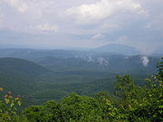
Ouachita Mountains
The Ouachita Mountains are a mountain range in west central Arkansas and southeastern Oklahoma. The range's subterranean roots may extend as far as central Texas, or beyond it to the current location of the Marathon Uplift. Along with the Ozark Mountains, the Ouachita Mountains form the U.S...
in Oklahoma, the Arbuckle Mountains
Arbuckle Mountains
The Arbuckle Mountains are an ancient mountain range in south-central Oklahoma in the United States. The granite rocks of the Arbuckles date back to the Proterozoic Era some 1.4 billion years ago which were overlain by sediments during the Paleozoic Era. The range reaches a height of 1,412 feet...
, and five other mountain ranges. The Ouachita National Forest
Ouachita National Forest
The Ouachita National Forest is a National Forest that lies in the western portion of Arkansas and portions of eastern Oklahoma.-History:The Ouachita National Forest is the oldest National Forest in the southern United States. The Forest encompasses , including most of the scenic Ouachita Mountains...
, Oklahoma's only national forest, is also in this area.
Kiamichi Country also houses "The World's Highest Hill," a 1,999-foot peak near Poteau
Poteau, Oklahoma
Poteau is a city in Le Flore County, Oklahoma, United States. It is part of the Fort Smith, Arkansas-Oklahoma Metropolitan Statistical Area. The population was 8,520 at the 2010 census, ranking fifth in the Greater Fort Smith Area. It is the county seat of Le Flore County...
, with the official designation for a "mountain" being anything 2,000-feet or taller.
The region contains Oklahoma's largest lake by surface area, Eufaula Lake
Eufaula Lake
Eufaula Lake is a reservoir in Oklahoma. It is located on the Canadian River, upstream from its confluence with the Arkansas River and near the town of Eufaula. It is the largest lake in the state of Oklahoma with and of shoreline....
. Other major lakes include Robert S. Kerr Reservoir
Robert S. Kerr Reservoir
Robert S. Kerr Reservoir is located within the Cookson Hills, on the Arkansas River in Sequoyah, Le Flore, Haskell, and Muskogee counties in eastern Oklahoma, USA. It is about eight miles south of the nearest major town, Sallisaw, Oklahoma. The reservoir is impounded by Robert S...
, Sardis Lake
Sardis Lake (Oklahoma)
Sardis Lake is a reservoir in Pushmataha County and Latimer County in Oklahoma, USA. The dam impounding the lake is located approximately north of Clayton. The lake covers with of shoreline. The lake is an impoundment of Jackfork Creek, a tributary of the Kiamichi River.The lake's normal pool...
, Hugo Lake
Hugo Lake
Hugo Lake is manmade lake located east of Hugo, in Choctaw County, Oklahoma, USA. It is formed by Hugo Lake Dam on the Kiamichi River upstream from the Red River. The dam is visible from U.S. Route 70, which crosses its spillway just west of Sawyer. Lake Hugo features approximately of...
, McGee Creek Reservoir
McGee Creek Reservoir
McGee Creek Reservoir is a reservoir in Atoka County, Oklahoma. It impounds the waters of McGee Creek and several smaller streams, including Potapo, Panther, Little Bugaboo, Bear, Blue, Mill, and Crooked creeks, all of which are tributaries of Muddy Boggy River.The lake, which was completed in...
, Pine Creek Lake
Pine Creek Lake
Pine Creek Lake is a lake in McCurtain County and Pushmataha County, Oklahoma, USA. It is located east of Rattan and north of Sobol.The lake, which was built in 1969, impounds the waters of Little River, Pine Creek, and Turkey Creek. It is managed by the U.S. Army Corps of Engineers for flood...
, Broken Bow Lake
Broken Bow Lake
Broken Bow Lake is a reservoir in southeast Oklahoma, located on Mountain Fork River and north of the town of Broken Bow. It is one of the largest lakes within the state of Oklahoma, and a popular tourist destination for locals and visitors from neighboring Texas.The lake stretches...
, Lake Wister
Lake Wister
Lake Wister is a reservoir in southeast Oklahoma. The lake is created by the Poteau River and the Fourche Maline creek. Wister Lake was authorized for flood control and conservation by the Flood Control Act of 1938. The project was designed and built by the Tulsa District Corps of Engineers...
, Lake Atoka Reservoir
Lake Atoka Reservoir
Lake Atoka Reservoir is a reservoir in southeastern Oklahoma. It was built in 1959 to expand the water supply for Lake Stanley Draper in Oklahoma City.- External links :*...
, and on Kiamichi Country's southwestern border, Lake Texoma
Lake Texoma
Lake Texoma is one of the largest reservoirs in the United States, the 12th largest Corps of Engineers lake, and the largest in USACE Tulsa District....
.
The region consists of the following counties in Oklahoma: Atoka
Atoka County, Oklahoma
Atoka County is a county located in the U.S. state of Oklahoma, and was formed in 1907 from Choctaw Lands. As of 2000, the population is 13,879. Its county seat is Atoka.-Geography:...
, Bryan
Bryan County, Oklahoma
Bryan County is a county located in the U.S. state of Oklahoma. The population was 36,534 at the 2000 census. Its county seat is Durant. The county shares the same boundaries as the Durant Micropolitan Area. It is also home to the headquarters of the Choctaw Nation of Oklahoma located in Durant...
, Choctaw
Choctaw County, Oklahoma
Choctaw County is a county located in the U.S. state of Oklahoma. As of 2000, the population was 15,342. Its county seat is Hugo.-Geography:According to the U.S. Census Bureau, the county has a total area of , of which is land and is water....
, Coal
Coal County, Oklahoma
Coal County is a county located in the U.S. state of Oklahoma. As of 2000, the population is 6,031. Its county seat is Coalgate.-Geography:According to the U.S. Census Bureau, the county has a total area of , of which is land and is water....
, Haskell
Haskell County, Oklahoma
Haskell County is a county located in the southeast quadrant of the U.S. state of Oklahoma. As of 2000, the population was 11,792. Its county seat is Stigler. The county is named in honor of Charles N. Haskell, who was the first governor of Oklahoma....
, Hughes
Hughes County, Oklahoma
Hughes County is a county located in the U.S. state of Oklahoma. As of 2000, the population was 14,154. Its county seat is Holdenville.-Geography:...
, Johnston
Johnston County, Oklahoma
Johnston County is a county located in the U.S. state of Oklahoma. As of 2000, the population was 10,513. Its county seat is Tishomingo.-Geography:...
, Latimer
Latimer County, Oklahoma
Latimer County is a county located in the U.S. state of Oklahoma. As of 2000, the population was 10,692. Its county seat is Wilburton.-Geography:According to the U.S. Census Bureau, the county has a total area of , of which is land and is water....
, Le Flore
Le Flore County, Oklahoma
Le Flore County is a county located in the U.S. state of Oklahoma. It is part of the Fort Smith, Arkansas-Oklahoma Metropolitan Statistical Area. As of 2000, the population was 48,109. Its county seat is Poteau. The United States District Court for the Eastern District of Oklahoma is the federal...
, Marshall
Marshall County, Oklahoma
Marshall County is a county located in the U.S. state of Oklahoma. As of 2000, the population was 13,184. Its county seat is Madill. The county's population grew at a rate of 35% in the 1990s and now it has a new population estimate at 20,000. Marshall County is the fastest growing county in...
, McCurtain
McCurtain County, Oklahoma
McCurtain County is a county located in the U.S. state of Oklahoma. As of 2010, the population was 33,151. Its county seat is Idabel.-Geography:...
, Pittsburg
Pittsburg County, Oklahoma
Pittsburg County is a county located in the U.S. state of Oklahoma. As of 2000, the population was 43,953. Its county seat is McAlester.-Geography:According to the U.S. Census Bureau, the county has a total area of 3,569 km²...
, Pushmataha
Pushmataha County, Oklahoma
-Administrative History:* Ca. 1000-1500: Caddoan Mississippian civilization at Spiro Mounds* 1492-1718: Spain* 1718-1763: France* 1763-1800: Spain* 1800-1803: France* 1803–present: United States...
.
Politics
The region is overwhelmingly DemocraticDemocratic Party (United States)
The Democratic Party is one of two major contemporary political parties in the United States, along with the Republican Party. The party's socially liberal and progressive platform is largely considered center-left in the U.S. political spectrum. The party has the lengthiest record of continuous...
—around 80%. Many of the citizens proudly refer to themselves as yellow-dog Democrats
Yellow dog Democrat
Yellow Dog Democrats was a political term applied to voters in the Southern United States who voted solely for Democratic candidates, with the term commencing in the late 19th century. Due to Republican president Abraham Lincoln's leading the Union against the Confederacy, these voters would...
. However many register as Democrats in order to vote in primaries then vote Republican in general elections. From statehood until 2003, most of the region was in its own Congressional
United States House of Representatives
The United States House of Representatives is one of the two Houses of the United States Congress, the bicameral legislature which also includes the Senate.The composition and powers of the House are established in Article One of the Constitution...
district, the 3rd District (numbered the 4th District from 1907 until 1915). Its best-known congressman was Carl Albert
Carl Albert
Carl Bert Albert was a lawyer and a Democratic American politician from Oklahoma.Albert represented the southeastern portion of Oklahoma as a Democrat for 30 years, starting in 1947. He is best known for his service as Speaker of the United States House of Representatives from 1971 to 1977...
, from McAlester in Pittsburg County, who represented the district for 30 years, the last six as Speaker of the House. Albert became synonymous with the region. At 5 feet 4 inches tall, he was known affectionately as the Little Giant from Little Dixie.
Albert retired in 1977 and was succeeded by Wes Watkins
Wes Watkins
Wesley Wade "Wes" Watkins is a politician from the state of Oklahoma. He is a retired member of the United States House of Representatives where Watkins had represented Oklahoma's 3rd Congressional District for 14 years as a Democrat and then for six years as a Republican.-Early life and...
, who held the seat for 14 years. He decided to run for governor
Governor of Oklahoma
The governor of the state of Oklahoma is the head of state for the state of Oklahoma, United States. Under the Oklahoma Constitution, the governor is also the head of government, serving as the chief executive of the Oklahoma executive branch, of the government of Oklahoma...
in 1990. However, the Democratic campaign tactics during the primary forced Watkins from the race (and eventually from the Democratic Party
Oklahoma Democratic Party
The Oklahoma Democratic Party is an Oklahoma political party affiliated with the United States Democratic Party. Along with the Oklahoma Republican Party, it one of the two major parties in Oklahoma politics....
). Watkins later shifted his party affiliation and registered as a Republican
Republican Party (United States)
The Republican Party is one of the two major contemporary political parties in the United States, along with the Democratic Party. Founded by anti-slavery expansion activists in 1854, it is often called the GOP . The party's platform generally reflects American conservatism in the U.S...
. In 1996, he easily won back his seat on the strength of his personal connection with the region's voters. Watkins’s victory led to several other Republican victories at the local level in the region.
After the 2000 U.S. Census, Oklahoma lost one seat in Congress. Most of the Little Dixie region was combined with northeastern Oklahoma to become Oklahoma's 2nd congressional district
Oklahoma's 2nd congressional district
Oklahoma's Second Congressional District is one of five United States Congressional districts in Oklahoma and covers approximately one-fourth of the state in the east...
. The region remains strongly Democratic politically. However, most of the Democrats in this region are fairly conservative by national standards. It is currently represented in Congress by Dan Boren
Dan Boren
Daniel David "Dan" Boren is the U.S. Representative for , serving since 2005. The district includes most of the eastern part of the state outside of Tulsa...
. According to the Chicago Tribune, among House Democrats, Rep. Dan Boren of Oklahoma backed former President Bush most often, with 77.9 percent of his votes, a higher score than 26 House Republicans can claim.
Tourism
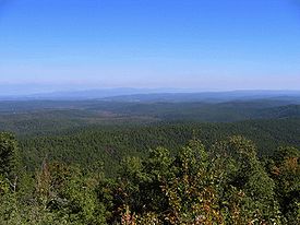
Ouachita Mountains
The Ouachita Mountains are a mountain range in west central Arkansas and southeastern Oklahoma. The range's subterranean roots may extend as far as central Texas, or beyond it to the current location of the Marathon Uplift. Along with the Ozark Mountains, the Ouachita Mountains form the U.S...
, 13 major lakes, the nearby Chickasaw National Recreation Area
Chickasaw National Recreation Area
Chickasaw National Recreation Areais a National Recreation Area situated in the foothills of the Arbuckle Mountains in south-central Oklahoma near Sulphur.-History:...
, state parks, and whitewater rapids sports. The Talimena Scenic Drive
Talimena Scenic Drive
The Talimena Scenic Drive is a National Scenic Byway in southeastern Oklahoma and extreme western Arkansas spanning a stretch of Oklahoma State Highway 1 and Arkansas Highway 88 from Talihina, Oklahoma, to Mena, Arkansas....
is also among top draws, traveling through the Ouachita National Forest
Ouachita National Forest
The Ouachita National Forest is a National Forest that lies in the western portion of Arkansas and portions of eastern Oklahoma.-History:The Ouachita National Forest is the oldest National Forest in the southern United States. The Forest encompasses , including most of the scenic Ouachita Mountains...
in the Winding Stair Mountains.
Demographics
Per the 2000 census, the region had 305,395 people. Whites equal about 76% of the total, American Indians total a little over 17%, and Blacks, almost 4%. Many of the blacks are descendants of the Choctaw freedmen (slaves held by the Choctaw and freed after the Civil War). The median per capita income is $13,948, almost $10,000 less than the state average of $23,517.Cities & Towns
The city of McAlesterMcAlester, Oklahoma
McAlester is a city in Pittsburg County, Oklahoma, United States. The population was 17,783 at the 2000 census. It is the county seat of Pittsburg County. It is currently the largest city in the Choctaw Nation of Oklahoma, followed by Durant....
serves as the region's primary urban center. Culturally and economically, it is a suburb of the more heavily populated cities of Green Country in Northeastern Oklahoma. Another major urban center that lies to the south is Durant
Durant, Oklahoma
Durant is a city in Bryan County, Oklahoma, United States. The population was 15,877 at the 2010 census. Durant is the principal city of the Durant Micropolitan Statistical Area, which had a population of 42,416 in 2010...
, which is ranked as one of the fastest growing cities in the United States
United States
The United States of America is a federal constitutional republic comprising fifty states and a federal district...
.
Other important cities and towns include, Atoka
Atoka, Oklahoma
Atoka is a city in Atoka County, Oklahoma, United States. The population was 3,052 at the 2010 census. It is the county seat of Atoka County.-Geography:Atoka is located at ....
, Poteau
Poteau, Oklahoma
Poteau is a city in Le Flore County, Oklahoma, United States. It is part of the Fort Smith, Arkansas-Oklahoma Metropolitan Statistical Area. The population was 8,520 at the 2010 census, ranking fifth in the Greater Fort Smith Area. It is the county seat of Le Flore County...
, Hugo
Hugo, Oklahoma
Hugo is a city in the southeastern part of the U.S. state of Oklahoma, bordering Texas. Hugo is the county seat for Choctaw County and has a population of 5,395 as of 2009 estimates. The city serves as winter quarters for some circus performers...
, Idabel
Idabel, Oklahoma
Idabel is a city in McCurtain County, Oklahoma, United States. The population was 7,658 at the 2000 census. It is the county seat of McCurtain County. The town is located in the tourist area Kiamichi Country.-History:...
, Broken Bow
Broken Bow, Oklahoma
Broken Bow is a city in McCurtain County, Oklahoma, United States. The population was 4,230 at the 2000 census. It is named after Broken Bow, Nebraska, the former hometown of the city's founders, the Dierks brothers.-History:...
, Talihina
Talihina, Oklahoma
Talihina is a town in Le Flore County, Oklahoma, United States, its name originating from two Choctaw words, tully and hena, meaning iron road. Iron road is reference to the railroad that the town was built around. It is part of the Fort Smith, Arkansas-Oklahoma Metropolitan Statistical Area...
, Clayton
Clayton, Oklahoma
Clayton is a town in Pushmataha County, Oklahoma, United States. The population was 719 at the 2000 census.- History :Clayton was formerly known as Dexter. A United States Post Office was established at Dexter, Indian Territory on March 31, 1894...
, Antlers
Antlers, Oklahoma
Antlers is a city in Pushmataha County, Oklahoma. The population was 2,552 at the 2000 census. It is the county seat of Pushmataha County.-Geography:Antlers is located at...
, Coalgate
Coalgate, Oklahoma
Coalgate is a city in and the county seat of Coal County, Oklahoma, United States. The population was 2,005 at the 2000 census.Morris W. Turner , a businessman and the mayor of Lubbock, Texas, from 1972–1974, was born in Coalgate.-Geography:...
and Wilburton
Wilburton, Oklahoma
Wilburton is a city in Latimer County, Oklahoma, United States. The city has a population of 2,972 at the 2000 census. It is the county seat of Latimer County.-Geography:Wilburton is located at ....
.