
Stenson, Derby
Encyclopedia
Stenson is a hamlet south of Derby
on the Trent and Mersey Canal
.
Between Stenson and Derby itself lies the busy A50
dual-carriageway and Stenson Fields, a large housing estate built between the early 1970s and late 1990s. Stenson Fields is constituted as a separate parish wholly within South Derbyshire
District, but it is essentially contiguous with the Sunny Hill
, Sinfin
and Littleover
suburbs of Derby city. The parish of Stenson Fields was created in 1983 from parts of the parish of Barrow-on-Trent and the parish of Twyford and Stenson. Originally called Sinfin Moor the name was later changed to Stenson Fields to be in keeping with the geographical and historical place name of the area. Sinfin Moor is a large tract of land to the east of Stenson Fields and Sinfin proper. Sinfin Moor is a Regionally Important Geological Site
(RIGS) which formed over the bed of an ice age lake. Part of the RIGS spills over into Stenson Fields close to the hamlet of Arleston
.
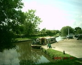
 Stenson Lock
is claimed to be the deepest on the canal; there is also a marina and a narrowboat
builders. The 'Stenson Bubble', after which the local waterside pub is named, is a small spring on the downstream side of the lock.
A railway line follows the line of the canal, part of a loop for freight bypassing Derby. This runs from the nearby Stenson Junction on the Derby-Birmingham line to Sheet Stores Junction
at Sawley on the Midland Main Line
.
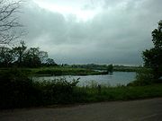 Stenson itself is parished with Twyford, . a similar village about one mile (1.6 km) to the south, on the north bank of the River Trent
.
Twyford and Stenson are mentioned in 1086 in the Domesday book
. The book says under the title of “The lands of Henry de Ferrers
The river crossing there has not been used in recent times; there was a chain ferry
there until 1963.http://www.igreens.org.uk/twyford_ferry_1899.jpg
St Andrew's Church at Twyford is an unusual sight as from the outside it appears to be of brick construction with stone extensions and steeple. In fact the brickwork is just a fascia as internal investigation reveals. It is about 220 yards (201.2 m) from the River Trent which floods every winter but never, it seems, has the church been flooded. However it has been damaged by lightning in 1821 and a fire in 1910. The lower part of the tower dates from 1200. Local tradition tells of “food being handed out to wayfarers from a stone framed window in a nearby farmhouse. This charity was administered by monks from a religious house of the Knights Hospitallers at the village of Arleston
.
Derby
Derby , is a city and unitary authority in the East Midlands region of England. It lies upon the banks of the River Derwent and is located in the south of the ceremonial county of Derbyshire. In the 2001 census, the population of the city was 233,700, whilst that of the Derby Urban Area was 229,407...
on the Trent and Mersey Canal
Trent and Mersey Canal
The Trent and Mersey Canal is a in the East Midlands, West Midlands, and North West of England. It is a "narrow canal" for the vast majority of its length, but at the extremities—east of Burton upon Trent and west of Middlewich—it is a wide canal....
.
Between Stenson and Derby itself lies the busy A50
A50 road
The A50 is a major trunk road in England. It runs from Warrington to Leicester; however, it was once a much longer route.-Current route:...
dual-carriageway and Stenson Fields, a large housing estate built between the early 1970s and late 1990s. Stenson Fields is constituted as a separate parish wholly within South Derbyshire
South Derbyshire
South Derbyshire is a local government district in Derbyshire, England. It contains a third of the National Forest, and the council offices are in Swadlincote....
District, but it is essentially contiguous with the Sunny Hill
Sunny Hill, Derby
Sunny Hill, Derby is situated mainly along the Stenson Road . It lies the between the Derby City districts of Normanton and Littleover, and, to the south, Sinfin, and the parish of Stenson Fields in South Derbyshire district.The hill on which the area is named is somewhat vague in its location even...
, Sinfin
Sinfin
Sinfin is a southern suburb of Derby, England, historically it was a separate village. It contained the main centre of Rolls-Royce, on Nightingale Road...
and Littleover
Littleover
Littleover is a large suburb of Derby, England situated between Rose Hill, Normanton, Sunny Hill, South Derbyshire and Mickleover about three miles south west of Derby city centre.-History:The history of the name of Littleover is simple...
suburbs of Derby city. The parish of Stenson Fields was created in 1983 from parts of the parish of Barrow-on-Trent and the parish of Twyford and Stenson. Originally called Sinfin Moor the name was later changed to Stenson Fields to be in keeping with the geographical and historical place name of the area. Sinfin Moor is a large tract of land to the east of Stenson Fields and Sinfin proper. Sinfin Moor is a Regionally Important Geological Site
Regionally Important Geological Site
Regionally Important Geological and Geomorphological Sites are locally designated sites of local, national and regional importance for geodiversity in the United Kingdom. RIGS may be designated for their value to Earth Science, and to Earth heritage in general, and may include cultural,...
(RIGS) which formed over the bed of an ice age lake. Part of the RIGS spills over into Stenson Fields close to the hamlet of Arleston
Arleston
Arleston is a hamlet to the south of the city of Derby in England. Its population is 32 and it is merely 16 houses clustered together surrounded by farmland, 7 of which lie around Arleston Farm to the north of the settlement and the remaining 9 to the south of the settlement in the vicinity of...
.
Lock (water transport)
A lock is a device for raising and lowering boats between stretches of water of different levels on river and canal waterways. The distinguishing feature of a lock is a fixed chamber in which the water level can be varied; whereas in a caisson lock, a boat lift, or on a canal inclined plane, it is...
is claimed to be the deepest on the canal; there is also a marina and a narrowboat
Narrowboat
A narrowboat or narrow boat is a boat of a distinctive design, made to fit the narrow canals of Great Britain.In the context of British Inland Waterways, "narrow boat" refers to the original working boats built in the 18th, 19th, and 20th centuries for carrying goods on the narrow canals...
builders. The 'Stenson Bubble', after which the local waterside pub is named, is a small spring on the downstream side of the lock.
A railway line follows the line of the canal, part of a loop for freight bypassing Derby. This runs from the nearby Stenson Junction on the Derby-Birmingham line to Sheet Stores Junction
Trent railway station
Trent railway station was situated near Long Eaton in Derbyshire at the junction of the Midland Railway line from London to Derby and Nottingham...
at Sawley on the Midland Main Line
Midland Main Line
The Midland Main Line is a major railway route in the United Kingdom, part of the British railway system.The present-day line links London St...
.
Twyford
River Trent
The River Trent is one of the major rivers of England. Its source is in Staffordshire on the southern edge of Biddulph Moor. It flows through the Midlands until it joins the River Ouse at Trent Falls to form the Humber Estuary, which empties into the North Sea below Hull and Immingham.The Trent...
.
Twyford and Stenson are mentioned in 1086 in the Domesday book
Domesday Book
Domesday Book , now held at The National Archives, Kew, Richmond upon Thames in South West London, is the record of the great survey of much of England and parts of Wales completed in 1086...
. The book says under the title of “The lands of Henry de Ferrers
Henry de Ferrers
Henry de Ferrers was a Norman soldier from a noble family who took part in the conquest of England and is believed to have fought at the Battle of Hastings of 1066 and, in consequence, was rewarded with much land in the subdued nation.His elder brother William fell in the battle. William and Henri...
”In Twyford and Stenson Leofric had four carucates of land to the geld. There is land for three ploughs (plows). There are now two ploughs in demesne and four villans and five bordars with one plough and one mill rendering 5 shillings have one plough. There is one mill rendering 2 shillings and 24 acres (97,124.6 m²) of meadow, woodland pasture one furlong long and one much broad. TRE worth eight pounds now four pounds.“
The river crossing there has not been used in recent times; there was a chain ferry
Cable ferry
A cable ferry is guided and in many cases propelled across a river or other larger body of water by cables connected to both shores. They are also called chain ferries, floating bridges, or punts....
there until 1963.http://www.igreens.org.uk/twyford_ferry_1899.jpg
St Andrew's Church at Twyford is an unusual sight as from the outside it appears to be of brick construction with stone extensions and steeple. In fact the brickwork is just a fascia as internal investigation reveals. It is about 220 yards (201.2 m) from the River Trent which floods every winter but never, it seems, has the church been flooded. However it has been damaged by lightning in 1821 and a fire in 1910. The lower part of the tower dates from 1200. Local tradition tells of “food being handed out to wayfarers from a stone framed window in a nearby farmhouse. This charity was administered by monks from a religious house of the Knights Hospitallers at the village of Arleston
Arleston
Arleston is a hamlet to the south of the city of Derby in England. Its population is 32 and it is merely 16 houses clustered together surrounded by farmland, 7 of which lie around Arleston Farm to the north of the settlement and the remaining 9 to the south of the settlement in the vicinity of...
.