
Stemple Creek
Encyclopedia
Stemple Creek is a 16 mi (26 km) long, westward-flowing stream
in the California
counties of Sonoma
and Marin
, which feeds into the Estero de San Antonio
. Its waters ultimately reach Bodega Bay
, part of the Gulf of the Farallones National Marine Sanctuary
on the Pacific Ocean
.
. It crosses under Stony Point Road and runs about 1 mi (1.6 km) southeast before turning westward. It passes south of Two Rock, California
, then crosses into Marin County just west of Training Center Petaluma
. The creek follows a sinous course across northern West Marin
, with bridges at Alexander Road, Twin Bridge Road, and State Route 1
, to a confluence with the Estero de San Antonio
just west of State Route 1.
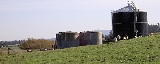
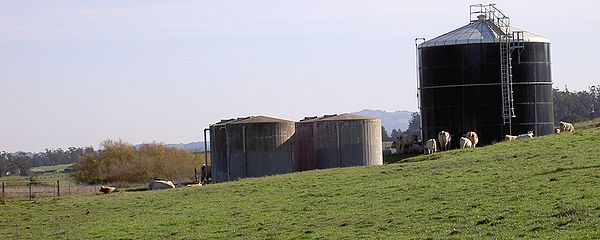 California's 1994 water quality report designated Stemple Creek as an "impaired" streamway as defined in section 303(d) of the Federal Water Resource Statutes, due to runoff from pasture land and feedlots. Pollutants found at hazardous level in the creek have included copper
, ammonia
, and zinc
.
s cross Stemple Creek at Route One, Pepper Road, Twn Bridge Road, Alexander Road, Tomales Road, Valley Ford Road, Mecham Road, and Pepper Road. The newest and longest of these, built in 1982, is the 210 ft (64 m) long concrete slab
structure at milepost 47.41 on State Route 1. The oldest, built in 1915, is the 39 ft (11.9 m) concrete tee beam bridge carrying Valley Ford Road, located 7.5 mi (12.1 km) from State Route 1.
Stream
A stream is a body of water with a current, confined within a bed and stream banks. Depending on its locale or certain characteristics, a stream may be referred to as a branch, brook, beck, burn, creek, "crick", gill , kill, lick, rill, river, syke, bayou, rivulet, streamage, wash, run or...
in the California
California
California is a state located on the West Coast of the United States. It is by far the most populous U.S. state, and the third-largest by land area...
counties of Sonoma
Sonoma County, California
Sonoma County, located on the northern coast of the U.S. state of California, is the largest and northernmost of the nine San Francisco Bay Area counties. Its population at the 2010 census was 483,878. Its largest city and county seat is Santa Rosa....
and Marin
Marin County, California
Marin County is a county located in the North San Francisco Bay Area of the U.S. state of California, across the Golden Gate Bridge from San Francisco. As of 2010, the population was 252,409. The county seat is San Rafael and the largest employer is the county government. Marin County is well...
, which feeds into the Estero de San Antonio
Estero de San Antonio
Estero de San Antonio is a stream in the northern California counties of Marin and Sonoma which empties into Bodega Bay.-Course:The Estero springs just north of the Marin-Sonoma county line and runs south along Gericke Road into Marin County...
. Its waters ultimately reach Bodega Bay
Bodega Bay
Bodega Bay is a shallow, rocky inlet of the Pacific Ocean on the coast of northern California in the United States. It is approximately across and is located approximately northwest of San Francisco and west of Santa Rosa...
, part of the Gulf of the Farallones National Marine Sanctuary
Gulf of the Farallones National Marine Sanctuary
The Gulf of the Farallones National Marine Sanctuary is one of 13 marine sanctuaries in the U.S., found outside San Francisco's Golden Gate surrounding the Gulf of the Farallones-History:...
on the Pacific Ocean
Pacific Ocean
The Pacific Ocean is the largest of the Earth's oceanic divisions. It extends from the Arctic in the north to the Southern Ocean in the south, bounded by Asia and Australia in the west, and the Americas in the east.At 165.2 million square kilometres in area, this largest division of the World...
.
Course
Stemple Creek springs from low-lying coastal hills 2 mi (3 km) southwest of CotatiCotati, California
Cotati is an incorporated city in Sonoma County, California, U.S.A., located about north of San Francisco in the 101 corridor between Rohnert Park and Petaluma....
. It crosses under Stony Point Road and runs about 1 mi (1.6 km) southeast before turning westward. It passes south of Two Rock, California
Two Rock, California
Two Rock is an unincorporated community in Sonoma County, California, United States. It is located on Stemple Creek in a rural area west of Petaluma...
, then crosses into Marin County just west of Training Center Petaluma
Training Center Petaluma
Training Center Petaluma is a Coast Guard training facility in the northern California counties of Sonoma and Marin. Approximately 4,000 students train there each year. It was formerly the U.S. Army Two Rock Ranch Station....
. The creek follows a sinous course across northern West Marin
West Marin
West Marin is the largest rural region of Marin County, California.The West Marin Chamber of Commerce includes seven unincorporated communities in its definition of West Marin: Point Reyes Station, Olema, Stinson Beach, Bolinas, Tomales, Dillon Beach, and Inverness...
, with bridges at Alexander Road, Twin Bridge Road, and State Route 1
California State Route 1
State Route 1 , more often called Highway 1, is a state highway that runs along much of the Pacific coast of the U.S. state of California. It is famous for running along some of the most beautiful coastlines in the world, leading to its designation as an All-American Road.Highway 1 does not run...
, to a confluence with the Estero de San Antonio
Estero de San Antonio
Estero de San Antonio is a stream in the northern California counties of Marin and Sonoma which empties into Bodega Bay.-Course:The Estero springs just north of the Marin-Sonoma county line and runs south along Gericke Road into Marin County...
just west of State Route 1.
Environmental factors
Copper
Copper is a chemical element with the symbol Cu and atomic number 29. It is a ductile metal with very high thermal and electrical conductivity. Pure copper is soft and malleable; an exposed surface has a reddish-orange tarnish...
, ammonia
Ammonia
Ammonia is a compound of nitrogen and hydrogen with the formula . It is a colourless gas with a characteristic pungent odour. Ammonia contributes significantly to the nutritional needs of terrestrial organisms by serving as a precursor to food and fertilizers. Ammonia, either directly or...
, and zinc
Zinc
Zinc , or spelter , is a metallic chemical element; it has the symbol Zn and atomic number 30. It is the first element in group 12 of the periodic table. Zinc is, in some respects, chemically similar to magnesium, because its ion is of similar size and its only common oxidation state is +2...
.
Bridges
BridgeBridge
A bridge is a structure built to span physical obstacles such as a body of water, valley, or road, for the purpose of providing passage over the obstacle...
s cross Stemple Creek at Route One, Pepper Road, Twn Bridge Road, Alexander Road, Tomales Road, Valley Ford Road, Mecham Road, and Pepper Road. The newest and longest of these, built in 1982, is the 210 ft (64 m) long concrete slab
Concrete slab
A concrete slab is a common structural element of modern buildings. Horizontal slabs of steel reinforced concrete, typically between 10 and 50 centimeters thick, are most often used to construct floors and ceilings, while thinner slabs are also used for exterior paving.In many domestic and...
structure at milepost 47.41 on State Route 1. The oldest, built in 1915, is the 39 ft (11.9 m) concrete tee beam bridge carrying Valley Ford Road, located 7.5 mi (12.1 km) from State Route 1.