

Steamboats of the Peace River
Encyclopedia
Peace River (Canada)
The Peace River is a river in Canada that originates in the Rocky Mountains of northern British Columbia and flows to the northeast through northern Alberta. The Peace River flows into the Slave River, a tributary of the Mackenzie River. The Mackenzie is the 12th longest river in the world,...
, which flows from the Rocky Mountain in British Columbia to Peace-Athabasca Delta
Peace-Athabasca Delta
The Peace–Athabasca Delta is a large freshwater, inland delta in northeastern Alberta located where the Peace and Athabasca Rivers join the Slave River at the western end of Lake Athabasca.-Conservation :...
and Lake Athabasca
Lake Athabasca
Lake Athabasca is located in the northwest corner of Saskatchewan and the northeast corner of Alberta between 58° and 60° N.-History:The name in the Dene language originally referred only to the large delta formed by the confluence the Athabasca River at the southwest corner of the lake...
in Alberta, was navigable by late nineteenth and early twentieth century steamboats from the Rocky Mountain Falls at Hudson's Hope
Hudson's Hope, British Columbia
Hudson's Hope is a district municipality in northeastern British Columbia, Canada, in the Peace River Regional District. It covers an area of with a population of 1,157 people. Having been first settled in 1805, it is the third oldest community in the province, although it was not incorporated...
to Fort Vermilion, where there was another set of rapids, then via the lower Peace from Vermilion to Lake Athabaska. The Peace is part of the Mackenzie Basin
Mackenzie Basin
The Mackenzie Basin , is an elliptical intermontane basin, located in the Mackenzie and Waitaki Districts, near the centre of the South Island of New Zealand. It is the largest such basin in New Zealand...
, a larger river complex which includes the of the Athabasca
Athabasca River
The Athabasca River originates from the Columbia Glacier of the Columbia Icefield in Jasper National Park in Alberta, Canada...
, Slave
Slave River
The Slave River is a Canadian river that flows from Lake Athabasca in northeastern Alberta and empties into Great Slave Lake in the Northwest Territories....
, and MacKenzie River
Mackenzie River
The Mackenzie River is the largest river system in Canada. It flows through a vast, isolated region of forest and tundra entirely within the country's Northwest Territories, although its many tributaries reach into four other Canadian provinces and territories...
s.
The Athabasca had large rapids too at Grande Rapids and Fort Smith
Fort Smith, Northwest Territories
Fort Smith is a town in the South Slave Region of the Northwest Territories, Canada. It is located in the southeastern portion of the Northwest Territories, on the Slave River and adjacent to the NWT/Alberta border.-History:Fort Smith's history began because of the Slave River and the vital link...
; in this way the rivers were sectional as various boats worked upper and lower sections. The Peace River system was the western arm of the complex. Travellers to the Peace would pack or Red River Cart from Fort Edmonton
Fort Edmonton
Fort Edmonton was the name of a series of trading posts of the Hudson's Bay Company from 1795 to 1891, all of which were located in central Alberta, Canada...
eighty miles north to Athabaska Landing. Boats bound for the Peace block would travel all the way north on the Athabasca River to Lake Athabasca, to get to the mouth of the Peace and then turn around southwest again. Traditionally, canoes provided transport in the area.
The first motorized vessel on the Peace system was the , built by the Hudson's Bay Company
Hudson's Bay Company
The Hudson's Bay Company , abbreviated HBC, or "The Bay" is the oldest commercial corporation in North America and one of the oldest in the world. A fur trading business for much of its existence, today Hudson's Bay Company owns and operates retail stores throughout Canada...
in Fort Chipewyan in the winter of 1882-83. She carried freight 200 miles (321.9 km) up the Peace to Vermilion Chutes, where the company’s goods were portaged around the rapids and reloaded into a flotilla of scows and canoes for the journey onward."
The steamboats in the early days of the province provided transport to move food and supplies in and wheat and livestock out the five hundred miles of the Peace and 250 miles (402.3 km) of the Athabasca. Rolla
Rolla, British Columbia
Rolla is a small historic farming community in the Peace River district of North Eastern British Columbia. It was first founded about 1912 as a way stop and steamer landing on the Peace River. Farms were established as the prairie was open, and the soil was rich...
, Taylor
Taylor, British Columbia
The District of Taylor is a small town in northeastern British Columbia, Canada, located on mile 36 of the Alaska Highway. Taylor, a member municipality of the Peace River Regional District, covers an area of about 17 km² with 1,380 residents. As it is just south of the much larger city of...
, Dunvegan
Dunvegan, Alberta
Dunvegan is an unincorporated community within the Municipal District of Fairview No. 136 in northern Alberta, Canada. It is located south of the town of Fairview on the northern bank of the Peace River at the mouth of the Dunvegan Creek....
, Peace RIver Landing
Peace River, Alberta
Peace River is a town in northwestern Alberta, Canada, situated along the banks of the Peace River, at its confluence with the Smoky River, the Heart River and Pat's Creek. It is located northwest of Edmonton, and northeast of Grande Prairie, along Highway 2. The Peace River townsite is nearly ...
and Fort Vermilion were put-in points.
Sternwheelers
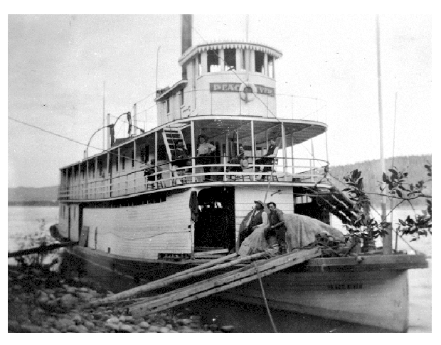
The Catholic mission at Dunvegan ran the first sternwheeler, the St. Charles in 1902. Built for Bishop Emile Grouard, her primary purpose was to aid him in his missionary work. She also carried goods for the North-West Mounted Police and the HBC. In 1905, the HBC launched a sternwheeler of their own, the Peace River. Built at Fort Vermilion, this 110 feet (33.5 m) long vessel could carry forty tons of freight and worked on the Peace River for ten years., until she was taken through the rapids below Fort Vermilion.Steamboats had a limited season, often making only making 3 or 4 trips a year. These trips up and down the river would take several weeks, depending on conditions and sand bars. Boats did not travel at night due to limited visibility.
Wood was the traditional fuel and these sternwheelers could burn as much as three or four cords of wood per hour. Paying passengers had no guarantee of a leisurely trip; although contractors were hired to cut and stack cordwood along the river, the sternwheelers often burned wood in such enormous quantities that the passengers would be called into service and set ashore with crosscuts and axes to replenish the wood supply. The season was short due to winter and ice up and the boats had to be pulled from the water in winter to avoid destruction by the ice.

Peace River Block
The Peace River Block is an area of land located in northeastern British Columbia, in the Peace River Country. In exchange for building a rail line across Canada to British Columbia the Canadian Pacific Railway was given a belt, on each side of the rail, of land...
only being opened up about 1910, so followed the steamboats. The Grenfell was built in 1912 at Peace River, but sadly sunk two years later. The Northland Call was also made in Peace River and ran for half a dozen years in the teens. The D.A Thomas was built in 1915 by Baron Rhondda of Wales, the British Peerage name for same D.A. Thomas, who was a coal baron in the British Isles. He wanted to exploit the coal and oil deposits of Chetwynd
Chetwynd, British Columbia
The District of Chetwynd is a town located on the foothills of the Rocky Mountains in northeastern British Columbia, Canada. Situated on an ancient floodplain, it is the first town eastbound travellers encounter after emerging from the Rockies along Highway 97 and acts as the gateway to the Peace...
, and so built the 168 feet (51.2 m), huge leviathan. She was quite unsuccessful owing to the First World War, although she ran until 1929. The D.A. Thomas steamed proudly up and down the Peace until the late 1920s, but the expansion of rail into the area finally made her uneconomic and obsolete. In June 1930 she took the drop over the Vermilion Chutes, suffering some damage on the rocks, and then limped on to Fort Fitzgerald. There, she was dismantled and scrapped with parts being used for other purposes including storing grain - an inglorious end for a fine ship. Other sternwheelers of that era included the Pine Pass, the Northland Echo and the Lady Mackworth, sister ship to the D.A. Thomas.
End of an era
For the years from 1915 to 1925 the Peace River artery became the easier route to the north and Peace River town became the shipping off point. The boats were transferred to the upper and lower Peace, and the Slave River. At this time the HBC ran all their boats down the Peace system to the Mackenzie River chain, boats like the Prospector and Distributor, which were useful in the war for the Norman Wells Canol project. The Hudson's Bay Company boats steamed until 1948.The arrival of the Model T Ford, and bulldozer
Bulldozer
A bulldozer is a crawler equipped with a substantial metal plate used to push large quantities of soil, sand, rubble, etc., during construction work and typically equipped at the rear with a claw-like device to loosen densely-compacted materials.Bulldozers can be found on a wide range of sites,...
, and gravelled roads, finished the river steamers in the Peace River Block. Also, the Edmonton, Dunvegan and British Columbia Railway
Edmonton, Dunvegan and British Columbia Railway
The Edmonton, Dunvegan and British Columbia Railway was an early pioneer railway in northwestern Alberta, designed to open up the Peace River district....
worked its way to BC and arrived in Dawson Creek in 1930, completely doing in the steamboat era. Farther east the Northern Alberta Railway and the Alberta Northern Waterways railway bypassed the worst rapids on the Upper Athabasca River by rail and thus made Waterways, or modern Fort McMurray, the transport head for the Peace and Athabasca Rivers. Other Railways—the Central Canada and Pembina—tried to alleviate transport woes but became weakened by the Depression
Great Depression
The Great Depression was a severe worldwide economic depression in the decade preceding World War II. The timing of the Great Depression varied across nations, but in most countries it started in about 1929 and lasted until the late 1930s or early 1940s...
and were not completed.
Smaller boats of various kinds continued to work on the Peace for another 20 years, but the age of steamboats was gone. The final commercial freight run up the Peace River was made by the Watson Lake, a steel-hulled vessel, in September 1952. Her last trip completed, she was hauled out of the water and loaded on a flatcar and shipped by rail to Waterways to continue work up north.
The US Army built a diesel paddler for tug service on the Peace River in 1942. It worked on the raising of the Peace River Bridge
Peace River Suspension Bridge
The Peace River Suspension Bridge was a bridge near Taylor, British Columbia, Canada crossing the Peace River. It opened in 1943 and collapsed on October 16, 1957 with no injuries or fatalities recorded.. When it opened, it was the longest bridge on the Alaska highway at 2,130 feet. When it...
(part of the Alaska Highway
Alaska Highway
The Alaska Highway was constructed during World War II for the purpose of connecting the contiguous U.S. to Alaska through Canada. It begins at the junction with several Canadian highways in Dawson Creek, British Columbia and runs to Delta Junction, Alaska, via Whitehorse, Yukon...
), the re-located and exiled bad boy bridge of Tacoma Narrows Bridge
Tacoma Narrows Bridge
The Tacoma Narrows Bridge is a pair of twin suspension bridges in the U.S. state of Washington, which carry State Route 16 across the Tacoma Narrows strait of Puget Sound between Tacoma and the Kitsap Peninsula...
. It promptly collapsed again in 1957.
See also
- David Alfred Thomas, 1st Viscount Rhondda
- Steamboats of the Mackenzie RiverSteamboats of the Mackenzie RiverThe Great Mackenzie River in Canada's North is a major artery. Used for thousands of years by the Dene, Beaver , Cree and Athabaskan natives, it was explored by the Scot who lent his name. The river was an important communication link to the North, in a land that for years did not have roads,...
- Steamboats of the Upper Fraser River
- Steamboats of the Skeena RiverSteamboats of the Skeena RiverThe Skeena River is British Columbia’s fastest flowing waterway, often rising as much as in a day and can fluctuate as much as sixty feet between high and low water. For the steamboat captains, that made it one of the toughest navigable rivers in British Columbia...
Further reading
- Pioneer Days in British Columbia Volume Two Art Downs and Harold Fryer ISBN 0-9690546-2-9