
Lake Athabasca
Encyclopedia
Lake Athabasca is located in the northwest corner of Saskatchewan
and the northeast corner of Alberta
between 58°
and 60° N
.
, cartographer for the Hudson’s Bay Company, wrote in his journal, "low swampy ground on the South side with a few willows growing upon it, from which the Lake in general takes its name Athapison in the Southern Cree tongue which signifies open country such as lakes with willows and grass growing about them". Peter Fidler
originally recorded the name for the river in 1790 as the Great Arabuska. By 1801, the name had gained a closer spelling to the current name—Athapaskow Lake. By 1820, George Simpson
referred to both the lake and the river as "Athabasca".
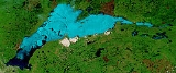
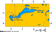 The lake covers 7850 km² (3,030.9 sq mi), is 283 km (175.8 mi) long, has a maximum width of 50 km (31.1 mi), and a maximum depth of 124 m (406.8 ft), and holds 204 km³ (48.9 cu mi) of water, making it the largest and deepest lake in both Alberta and Saskatchewan, and the eighth largest in Canada
. Water flows northward from the lake via the Slave River
and Mackenzie River
systems, eventually reaching the Arctic Ocean
. Fort Chipewyan, one of the oldest European settlements in Alberta, is located on the western shore of the lake, where the Rivière des Rochers drains the lake and flows toward Slave River
, beginning its northward journey along the eastern boundary of Wood Buffalo National Park
.
Fidler Point on the north shore of Lake Athabasca is named for Peter Fidler
, a surveyor and map maker for the Hudson's Bay Company
.
and gold
mining
along the northern shore resulted in the birth of Uranium City, Saskatchewan
, which was home to the mine workers and their families. While the last mine closed in the 1980s, the effects of mining operations have heavily contaminated the northern shores.
The Lake Athabasca Sand Dunes, the largest active sand dunes in the world north of 58°, are adjacent to the southern shore. After a long struggle with government bureaucracy and opposition from mining companies, the dunes were designated a "Provincial Wilderness Park" in 1992.
Lake Athabasca contains 23 species of fish
, with a world record lake trout
of 46.3 kg (102.1 lb) having been caught from its depths in 1961 by means of a gillnet
.
Other fish species include walleye
, yellow perch
, northern pike
, lake trout
, goldeye
, lake whitefish
, cisco
, arctic grayling
, burbot
, white sucker
and longnose sucker
.
Saskatchewan
Saskatchewan is a prairie province in Canada, which has an area of . Saskatchewan is bordered on the west by Alberta, on the north by the Northwest Territories, on the east by Manitoba, and on the south by the U.S. states of Montana and North Dakota....
and the northeast corner of Alberta
Alberta
Alberta is a province of Canada. It had an estimated population of 3.7 million in 2010 making it the most populous of Canada's three prairie provinces...
between 58°
58th parallel north
The 58th parallel north is a circle of latitude that is 58 degrees north of the Earth's equatorial plane. It crosses Europe, Asia, the Pacific Ocean, North America, and the Atlantic Ocean....
and 60° N
60th parallel north
The 60th parallel north is a circle of latitude that is 60 degrees north of the Earth's equatorial plane. It crosses Europe, Asia, the Pacific Ocean, North America, and the Atlantic Ocean....
.
History
The name in the Dene language originally referred only to the large delta formed by the confluence the Athabasca River at the southwest corner of the lake. In 1791, Philip TurnorPhilip Turnor
Philip Turnor was a surveyor and cartographer for the Hudson's Bay Company.Turnor hired on for three years as an inland surveyor with the HBC and landed at York Factory in August, 1778...
, cartographer for the Hudson’s Bay Company, wrote in his journal, "low swampy ground on the South side with a few willows growing upon it, from which the Lake in general takes its name Athapison in the Southern Cree tongue which signifies open country such as lakes with willows and grass growing about them". Peter Fidler
Peter Fidler (explorer)
Peter Fidler was a British surveyor, map-maker, chief fur trader and explorer who had a long career in the employ of the Hudson's Bay Company in what later became Canada. He was born in Bolsover, Derbyshire, England and died at Fort Dauphin in present day Manitoba...
originally recorded the name for the river in 1790 as the Great Arabuska. By 1801, the name had gained a closer spelling to the current name—Athapaskow Lake. By 1820, George Simpson
George Simpson (administrator)
Sir George Simpson was a Scots-Quebecer and employee of the Hudson's Bay Company . His title was Governor-in-Chief of Rupert's Land and administrator over the Northwest Territories and Columbia Department in British North America from 1821 to 1860.-Early years:George Simpson was born in Dingwall,...
referred to both the lake and the river as "Athabasca".
Geography
Canada
Canada is a North American country consisting of ten provinces and three territories. Located in the northern part of the continent, it extends from the Atlantic Ocean in the east to the Pacific Ocean in the west, and northward into the Arctic Ocean...
. Water flows northward from the lake via the Slave River
Slave River
The Slave River is a Canadian river that flows from Lake Athabasca in northeastern Alberta and empties into Great Slave Lake in the Northwest Territories....
and Mackenzie River
Mackenzie River
The Mackenzie River is the largest river system in Canada. It flows through a vast, isolated region of forest and tundra entirely within the country's Northwest Territories, although its many tributaries reach into four other Canadian provinces and territories...
systems, eventually reaching the Arctic Ocean
Arctic Ocean
The Arctic Ocean, located in the Northern Hemisphere and mostly in the Arctic north polar region, is the smallest and shallowest of the world's five major oceanic divisions...
. Fort Chipewyan, one of the oldest European settlements in Alberta, is located on the western shore of the lake, where the Rivière des Rochers drains the lake and flows toward Slave River
Slave River
The Slave River is a Canadian river that flows from Lake Athabasca in northeastern Alberta and empties into Great Slave Lake in the Northwest Territories....
, beginning its northward journey along the eastern boundary of Wood Buffalo National Park
Wood Buffalo National Park
Wood Buffalo National Park, located in northeastern Alberta and southern Northwest Territories, is the largest national park in Canada at . The park was established in 1922 to protect the world's largest herd of free roaming Wood Bison, currently estimated at more than 5,000...
.
Fidler Point on the north shore of Lake Athabasca is named for Peter Fidler
Peter Fidler (explorer)
Peter Fidler was a British surveyor, map-maker, chief fur trader and explorer who had a long career in the employ of the Hudson's Bay Company in what later became Canada. He was born in Bolsover, Derbyshire, England and died at Fort Dauphin in present day Manitoba...
, a surveyor and map maker for the Hudson's Bay Company
Hudson's Bay Company
The Hudson's Bay Company , abbreviated HBC, or "The Bay" is the oldest commercial corporation in North America and one of the oldest in the world. A fur trading business for much of its existence, today Hudson's Bay Company owns and operates retail stores throughout Canada...
.
Development and environment
UraniumUranium
Uranium is a silvery-white metallic chemical element in the actinide series of the periodic table, with atomic number 92. It is assigned the chemical symbol U. A uranium atom has 92 protons and 92 electrons, of which 6 are valence electrons...
and gold
Gold
Gold is a chemical element with the symbol Au and an atomic number of 79. Gold is a dense, soft, shiny, malleable and ductile metal. Pure gold has a bright yellow color and luster traditionally considered attractive, which it maintains without oxidizing in air or water. Chemically, gold is a...
mining
Mining
Mining is the extraction of valuable minerals or other geological materials from the earth, from an ore body, vein or seam. The term also includes the removal of soil. Materials recovered by mining include base metals, precious metals, iron, uranium, coal, diamonds, limestone, oil shale, rock...
along the northern shore resulted in the birth of Uranium City, Saskatchewan
Uranium City, Saskatchewan
Uranium City is a settlement in northwestern Saskatchewan, Canada. It is on the northern shores of Lake Athabasca near the border of the Northwest Territories. It is above sea level. The settlement is northwest of Prince Albert, 760 km northeast of Edmonton and south of the Northwest...
, which was home to the mine workers and their families. While the last mine closed in the 1980s, the effects of mining operations have heavily contaminated the northern shores.
The Lake Athabasca Sand Dunes, the largest active sand dunes in the world north of 58°, are adjacent to the southern shore. After a long struggle with government bureaucracy and opposition from mining companies, the dunes were designated a "Provincial Wilderness Park" in 1992.
Lake Athabasca contains 23 species of fish
Fish
Fish are a paraphyletic group of organisms that consist of all gill-bearing aquatic vertebrate animals that lack limbs with digits. Included in this definition are the living hagfish, lampreys, and cartilaginous and bony fish, as well as various extinct related groups...
, with a world record lake trout
Lake trout
Lake trout is a freshwater char living mainly in lakes in northern North America. Other names for it include mackinaw, lake char , touladi, togue, and grey trout. In Lake Superior, they can also be variously known as siscowet, paperbellies and leans...
of 46.3 kg (102.1 lb) having been caught from its depths in 1961 by means of a gillnet
Gillnet
Gillnetting is a common fishing method used by commercial and artisanal fishermen of all the oceans and in some freshwater and estuary areas. The gillnet also is used by fisheries scientists to monitor fish populations. Because gillnets can be so effective their use is closely monitored and...
.
Other fish species include walleye
Walleye
Walleye is a freshwater perciform fish native to most of Canada and to the northern United States. It is a North American close relative of the European pikeperch...
, yellow perch
Yellow perch
The yellow perch is a species of perch found in the United States and Canada, where it is often referred to by the shortform perch. Yellow perch look similar to the European perch, but are paler and more yellowish, with less red in the fins. They have six to eight dark, vertical bars on their sides...
, northern pike
Northern Pike
The northern pike , is a species of carnivorous fish of the genus Esox...
, lake trout
Lake trout
Lake trout is a freshwater char living mainly in lakes in northern North America. Other names for it include mackinaw, lake char , touladi, togue, and grey trout. In Lake Superior, they can also be variously known as siscowet, paperbellies and leans...
, goldeye
Goldeye
The goldeye, Hiodon alosoides, is a species of fish in the mooneye family . It occurs from as far down the Mackenzie River as Aklavik in the north to Mississippi in the south, and from Alberta in the west to Ohio south of the Great Lakes, with an isolated population south of James Bay. It is...
, lake whitefish
Lake whitefish
The lake whitefish , also called the Sault whitefish or gizzard fish, is a species of freshwater whitefish from North America. Lake whitefish are found throughout much of Canada and parts of the northern United States, including all of the Great Lakes. A valuable commercial fish, they are also...
, cisco
Cisco (fish)
The ciscoes are salmonid fish of the genus Coregonus that differ from other members of the genus in having upper and lower jaws of approximately equal length and high gillraker counts...
, arctic grayling
Arctic grayling
Arctic grayling is a species of freshwater fish in the salmon family of order Salmoniformes. It comprises five subspecies native to the Nearctic and Palearctic ecozones. T. a. arcticus is widespread throughout the Arctic and Pacific drainages in Canada, Alaska, and Siberia, as well as the upper...
, burbot
Burbot
The burbot is the only gadiform fish inhabiting freshwaters. It is also known as mariah, the lawyer, and eelpout. It is closely related to the marine common ling and the cusk...
, white sucker
White Sucker
The White Sucker is a bottom-feeding freshwater fish inhabiting North America from Labrador in the north to Georgia and New Mexico in the south. It is a long, round-bodied fish with a dark green, grey, copper, brown, or black back and sides and a light underbelly. When fullgrown, it is between 12...
and longnose sucker
Longnose sucker
The longnose sucker, Catostomus catostomus, is a freshwater species of fish inhabiting cold, clear waters in North America from northern USA to the top of the continent. In addition, it is one of two species of sucker to inhabit Asia, specifically the rivers of eastern Siberia...
.
External links
- Lake Athabasca and associated Sand Dunes
- International Lake Environment Committee, June 21, 2001
- http://www.publications.gov.sk.ca/details.cfm?p=11115 Fish Species of Saskatchewan
- http://esask.uregina.ca/entry/lake_athabasca.html Encyclopedia of Saskatchewan
- Athabaca Sand Dunes Provincial Park