

Bayou Teche
Encyclopedia
Louisiana
Louisiana is a state located in the southern region of the United States of America. Its capital is Baton Rouge and largest city is New Orleans. Louisiana is the only state in the U.S. with political subdivisions termed parishes, which are local governments equivalent to counties...
in the United States
United States
The United States of America is a federal constitutional republic comprising fifty states and a federal district...
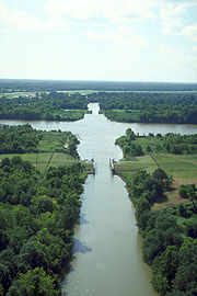
. Bayou Teche was the Mississippi River
Mississippi River
The Mississippi River is the largest river system in North America. Flowing entirely in the United States, this river rises in western Minnesota and meanders slowly southwards for to the Mississippi River Delta at the Gulf of Mexico. With its many tributaries, the Mississippi's watershed drains...
's main course when it developed a delta about 2,800 to 4,500 years ago. Through a natural process known as deltaic switching, the river's deposits of silt
Silt
Silt is granular material of a size somewhere between sand and clay whose mineral origin is quartz and feldspar. Silt may occur as a soil or as suspended sediment in a surface water body...
and sediment
Sediment
Sediment is naturally occurring material that is broken down by processes of weathering and erosion, and is subsequently transported by the action of fluids such as wind, water, or ice, and/or by the force of gravity acting on the particle itself....
cause the Mississippi to change its course every thousand years or so.
History
The Teche begins in Port Barre where it draws water from Bayou Courtableau and then flows southward to meet the Lower Atchafalaya RiverAtchafalaya River
The Atchafalaya River is a distributary of the Mississippi River and Red River in south central Louisiana in the United States. It flows south, just west of the Mississippi River....
at Patterson. During the time of the Acadian
Acadian
The Acadians are the descendants of the 17th-century French colonists who settled in Acadia . Acadia was a colony of New France...
migration to what was then known as the Attakapas region, the Teche was the primary means of transportation.
During the American Civil War
American Civil War
The American Civil War was a civil war fought in the United States of America. In response to the election of Abraham Lincoln as President of the United States, 11 southern slave states declared their secession from the United States and formed the Confederate States of America ; the other 25...
, fighting occurred on Bayou Teche on November 3–5, 1862. Four Federal gunboats with twenty-seven guns came up the Teche despite weak obstructions placed in the bayou by Confederate
Confederate States of America
The Confederate States of America was a government set up from 1861 to 1865 by 11 Southern slave states of the United States of America that had declared their secession from the U.S...
General Alfred Mouton
Alfred Mouton
Jean-Jacques-Alfred-Alexandre "Alfred" Mouton was a Confederate general in the American Civil War. He was born in Opelousas, Louisiana, and spent most of his life in Lafayette. Beloved by those under his command, Mouton was a strict drillmaster and disciplinarian who simultaneously freely...
. The gunboats engaged the Confederate ship Cotton near Cornay's Bridge in an exchange that lasted for an hour and a half. Though struck several times, the Cotton escaped real damage. In the next two days, two other duels occurred, and each time the Cotton prevailed. However, the Union
Union (American Civil War)
During the American Civil War, the Union was a name used to refer to the federal government of the United States, which was supported by the twenty free states and five border slave states. It was opposed by 11 southern slave states that had declared a secession to join together to form the...
pacified the area of Bayou Teche and the Atchafalaya River. Historian John D. Winters
John D. Winters
John David Winters was a historian at Louisiana Tech University in Ruston, Louisiana, best known for his definitive and award-winning study, The Civil War in Louisiana, still in print, published in 1963 and released in paperback in 1991.-Background:Winters was born to John David Winters, Sr...
reports: "Federal troops collected horses, mules, and sugar in large quantities. Planters who remained began taking the oath [to the U.S. government] and were allowed to make contracts with the Negro
Negro
The word Negro is used in the English-speaking world to refer to a person of black ancestry or appearance, whether of African descent or not...
es to finish their sugar crops."
After the levees were built along the Atachafalaya River in the 1930s, the Teche and the rice
Rice
Rice is the seed of the monocot plants Oryza sativa or Oryza glaberrima . As a cereal grain, it is the most important staple food for a large part of the world's human population, especially in East Asia, Southeast Asia, South Asia, the Middle East, and the West Indies...
farms located along the bayou suffered a drastic reduction in fresh water. Between 1976 and 1982, the United States Army Corps of Engineers
United States Army Corps of Engineers
The United States Army Corps of Engineers is a federal agency and a major Army command made up of some 38,000 civilian and military personnel, making it the world's largest public engineering, design and construction management agency...
built a pumping station at Krotz Springs
Krotz Springs, Louisiana
Krotz Springs is a town in St. Landry Parish, Louisiana on the Atchafalaya River. The population was 1,219 at the 2000 census. It is part of the Opelousas–Eunice Micropolitan Statistical Area.-History:...
to pump water from the Atchafalaya River into Bayou Courtableau.
The name "Teche" is a Chitimacha
Chitimacha
The Chitimacha are a Native American federally recognized tribe that lives in the U.S. state of Louisiana, mainly in St. Mary Parish. They currently number about 720 people. The Chitimacha language is a language isolate.- History :The Chitimacha's historic home was the southern Louisiana coast...
Indian word meaning "snake", related to the bayou's twists and turns resembling a snake's movement. The Chitimacha tell an ancient story of how the snake attacked their villages, and it took many warriors many years to kill it. Where the huge carcass lay and decomposed, the depression it left behind filled with water to become the bayou.
The sugar plantation Lagonda was established on Bayou Teche by Lewis Strong Clarke
Lewis Strong Clarke
Lewis Strong Clarke, Sr. , was the owner of a sugar plantation in St. Mary Parish and a leader of the Republican Party in Louisiana in the latter part of the 19th century....
, who was also involved in Republican
Republican Party (United States)
The Republican Party is one of the two major contemporary political parties in the United States, along with the Democratic Party. Founded by anti-slavery expansion activists in 1854, it is often called the GOP . The party's platform generally reflects American conservatism in the U.S...
politics in the late 19th century.
Towns on Bayou Teche
Towns along the Teche include:- St. Landry Parish, LouisianaSt. Landry Parish, LouisianaSt. Landry Parish is a parish located in the U.S. state of Louisiana. It is at the heart of Acadian/Cajun culture and heritage in Louisiana. The parish seat is Opelousas. According to the 2010 census, the population of St. Landry Parish is 83,384.St...
- Port Barre, LouisianaPort Barre, LouisianaPort Barre is a town in St. Landry Parish, Louisiana, United States. The population was 2,287 at the 2000 census. It is part of the Opelousas–Eunice Micropolitan Statistical Area...
- Leonville, LouisianaLeonville, LouisianaLeonville is a town in St. Landry Parish, Louisiana, United States. The population was 1,007 at the 2000 census. It is part of the Opelousas–Eunice Micropolitan Statistical Area.-Geography:Leonville is located at ....
- Arnaudville, LouisianaArnaudville, LouisianaArnaudville is a town in St. Landry and St. Martin parishes in the U.S. state of Louisiana. The population was 1,398 at the 2000 census.The St. Martin Parish portion of Arnaudville is part of the Lafayette Metropolitan Statistical Area, while the St...
- Port Barre, Louisiana
- St. Martin Parish, LouisianaSt. Martin Parish, LouisianaSt. Martin Parish is a parish located in the U.S. state of Louisiana. The parish seat is St. Martinville. As of the 2000 census, the population was 48,583.St...
- Cecilia, LouisianaCecilia, LouisianaCecilia is a census-designated place in St. Martin Parish, Louisiana, United States. The population was 1,505 at the 2000 census. It is part of the Lafayette Metropolitan Statistical Area.-Geography:Cecilia is located at ....
- Breaux Bridge, LouisianaBreaux Bridge, LouisianaBreaux Bridge is a city in St. Martin Parish, Louisiana, United States. The population is 8,139 as of the 2010 census. It is part of the Lafayette Metropolitan Statistical Area....
- Parks, LouisianaParks, LouisianaParks is a village in St. Martin Parish, Louisiana, United States. The population was 533 at the 2000 census. It is part of the Lafayette Metropolitan Statistical Area....
- St. Martinville, LouisianaSt. Martinville, LouisianaSt. Martinville is a city in and the parish seat of St. Martin Parish, Louisiana, United States. It lies on Bayou Teche, sixteen miles south of Breaux Bridge, eighteen miles southeast of Lafayette, and nine miles north of New Iberia. The population was 6,989 at the 2000 census. It is part of the...
- Cecilia, Louisiana
- Iberia Parish, LouisianaIberia Parish, LouisianaIberia Parish is a parish located in the U.S. state of Louisiana. The parish seat is New Iberia. As of 2000, the population was 73,266.Iberia Parish is part of the New Iberia Micropolitan Statistical Area as well as the Lafayette–Acadiana Combined Statistical Area.Iberia, along with...
- Loreauville, LouisianaLoreauville, LouisianaLoreauville is a village in Iberia Parish, Louisiana, United States. The population was 938 at the 2000 census. It is part of the New Iberia Micropolitan Statistical Area.-History:...
- New Iberia, LouisianaNew Iberia, LouisianaNew Iberia is a city in and the parish seat of Iberia Parish, Louisiana, United States, 30 miles southeast of Lafayette. In 1900, 6,815 people lived in New Iberia; in 1910, 7,499; and in 1940, 13,747...
- Jeanerette, LouisianaJeanerette, LouisianaJeanerette is a city in Iberia Parish, Louisiana, United States. Known as "Sugar City", it had a population of 5,997 at the 2000 census. It is part of the New Iberia Micropolitan Statistical Area.-Early years:...
- Loreauville, Louisiana
- St. Mary Parish, LouisianaSt. Mary Parish, LouisianaSt. Mary Parish is a parish located in the U.S. state of Louisiana. The parish seat is Franklin. As of 2000, the population was 53,500.The Morgan City Micropolitan Statistical Area includes all of St. Mary Parish.-Geography:...
- Charenton, LouisianaCharenton, LouisianaCharenton is a census-designated place in St. Mary Parish, Louisiana, United States. The population was 1,944 at the 2000 census. It is part of the Morgan City Micropolitan Statistical Area. According to legend, the community received its name from one of the earliest settlers of the region,...
- Baldwin, LouisianaBaldwin, LouisianaBaldwin is a town in St. Mary Parish, Louisiana, United States. The population was 2,497 at the 2000 census. It is part of the Morgan City Micropolitan Statistical Area....
- Berwick, LouisianaBerwick, LouisianaBerwick is a town in St. Mary Parish, Louisiana, United States. The population was 4,418 at the 2000 census. It is part of the Morgan City Micropolitan Statistical Area....
- Franklin, LouisianaFranklin, LouisianaFranklin is a city in and the parish seat of St. Mary Parish, Louisiana, United States. The population was 8,354 at the 2000 census. It is part of the Morgan City Micropolitan Statistical Area.-History:...
- Patterson, LouisianaPatterson, LouisianaPatterson is a small city in St. Mary Parish, Louisiana, United States. The population was 6,530 at the 2000 census. It is part of the Morgan City Micropolitan Statistical Area.-History:...
- Charenton, Louisiana