
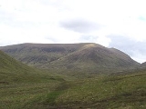
Sròn a' Choire Ghairbh
Encyclopedia
Scotland
Scotland is a country that is part of the United Kingdom. Occupying the northern third of the island of Great Britain, it shares a border with England to the south and is bounded by the North Sea to the east, the Atlantic Ocean to the north and west, and the North Channel and Irish Sea to the...
mountain situated on the northern side of Loch Lochy
Loch Lochy
Loch Lochy is a large freshwater loch in Lochaber, Highland, Scotland. With a mean depth of , it is the third deepest loch of Scotland.-Geography:...
, 13 kilometres north of Spean Bridge
Spean Bridge
Spean Bridge is a village, in the Highland region of Scotland.The village takes its name from the Highbridge over the River Spean on General Wade's military road between Fort William and Fort Augustus, and not from Telford's bridge of 1819 which carries the A82 over the river at the heart of the...
in the Highland
Highland (council area)
Highland is a council area in the Scottish Highlands and is the largest local government area in both Scotland and the United Kingdom as a whole. It shares borders with the council areas of Moray, Aberdeenshire, Perth and Kinross, and Argyll and Bute. Their councils, and those of Angus and...
Council area.
Overview
Sròn a’ Choire Ghairbh reaches a height of 937 metres (3074 feet) and is classified as both a MunroMunro
A Munro is a mountain in Scotland with a height over . They are named after Sir Hugh Munro, 4th Baronet , who produced the first list of such hills, known as Munros Tables, in 1891. A Munro top is a summit over 3,000 ft which is not regarded as a separate mountain...
and a Marilyn
Marilyn (hill)
A Marilyn is a mountain or hill in the United Kingdom, Republic of Ireland or Isle of Man with a relative height of at least 150 metres , regardless of absolute height or other merit...
. It is highest of the Loch Lochy hills and is invariably climbed along with the neighbouring Munro of Meall na Teanga
Meall na Teanga
Meall na Teanga is a Scottish mountain located in the Highland council area. 11 kilometres north of Spean Bridge.- Overview :Meall na Teanga is situated on the northern side of Loch Lochy and is closely associated with the adjacent Munro of Sròn a' Choire Ghairbh which lies two kilometres to the...
to which it is joined by the distinctive col
Mountain pass
A mountain pass is a route through a mountain range or over a ridge. If following the lowest possible route, a pass is locally the highest point on that route...
of the Cam Bhealach. Both these hills which are often referred to as the Loch Lochy Munros are well seen from the A82 road on the opposite side of the loch, showing steep slopes which are forested below the 300 metre contour. There are also extensive conifer plantings on the lower northern (Glen Garry) side of the mountain, this is gradually being restored to native species. The hills name translates from the Gaelic
Scottish Gaelic language
Scottish Gaelic is a Celtic language native to Scotland. A member of the Goidelic branch of the Celtic languages, Scottish Gaelic, like Modern Irish and Manx, developed out of Middle Irish, and thus descends ultimately from Primitive Irish....
as The Nose of the Rough Corrie referring to the summits location on the edge of the craggy Coire Glas, which stands to the east.
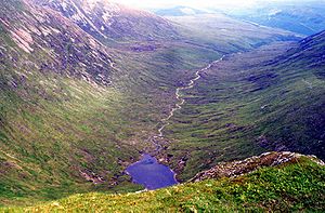
Geography
Sròn a’ Choire Ghairbh’s main geographical feature is the Coire Glas which has the small LochLoch
Loch is the Irish and Scottish Gaelic word for a lake or a sea inlet. It has been anglicised as lough, although this is pronounced the same way as loch. Some lochs could also be called a firth, fjord, estuary, strait or bay...
a’ Choire Ghlais within its upper recesses. The mountain is horse shoe shaped and throws down two ridges on either side of the corrie, the lengthy east ridge is five kilometres long and goes over the two subsidiary tops of Sean Mheall (888 metres) and Meall nan Dearcag (693 metres) before descending to the Kilfinnan Burn at the north end of Loch Lochy. Another ridge called Meall a’ Choire Ghlais goes north and then north east along the other side of Corrie Glas, it loses very little height for two kilometres before descending steeply and rockily to the Beallach Easain (548 metres) which connects it to the Corbett Ben Tee
Ben Tee
Ben Tee is a Scottish mountain situated in the Lochaber area of the Highland council area, some 15 kilometres north of Spean Bridge. It is rated as one of the best of Scotland’s smaller mountains with Hamish Brown saying:-Overview:...
.
In all other directions the mountain is steep and grassy, to the south lies the Cam Beallach, a mountain pass that links to the Munro Meall na Teanga, the Cam Beallach is seen as a distinct notch in the skyline between the two Munros whether viewed from the east or the west. To the north is the small Coire an Eich which drains north into Glen Garry to find its way to the sea at the east coast via Loch Ness
Loch Ness
Loch Ness is a large, deep, freshwater loch in the Scottish Highlands extending for approximately southwest of Inverness. Its surface is above sea level. Loch Ness is best known for the alleged sightings of the cryptozoological Loch Ness Monster, also known affectionately as "Nessie"...
. Sròn a’ Choire Ghairbh is actually on the main north-south water divide
Water divide
A drainage divide, water divide, divide or watershed is the line separating neighbouring drainage basins...
of Scotland with rainfall on all other parts of the hill going to the west coast via Loch Lochy
Loch Lochy
Loch Lochy is a large freshwater loch in Lochaber, Highland, Scotland. With a mean depth of , it is the third deepest loch of Scotland.-Geography:...
and Loch Linnhe
Loch Linnhe
Loch Linnhe is a sea loch on the west coast of Scotland....
.
Ascents
Sròn a’ Choire Ghairbh is nearly always climbed from the Cam Beallach, however there are two possible ways of arriving there. The southern approach starts at the car park at the Eas Cia-aig waterfall on the B8005 at grid reference , Gleann Cia-aig is ascended to its head where the Cam Beallach is clearly in view. The approach from the north east starts at the car park at Laggan Locks just off the A82 at grid reference and takes the rising track through the forest on Loch Lochy’s northern side to reach the Cam Beallach. The continuation to the summit from the Cam Beallach follows a very good stalkers path which zig zags up the mountainside to the highest point which overlooks Coire Glas. The mountain has a substantial prominence
Topographic prominence
In topography, prominence, also known as autonomous height, relative height, shoulder drop , or prime factor , categorizes the height of the mountain's or hill's summit by the elevation between it and the lowest contour line encircling it and no higher summit...
of 622 metres ensuring that the summit is a fine viewpoint for the surrounding mountains of Lochaber
Lochaber
District of Lochaber 1975 to 1996Highland council area shown as one of the council areas of ScotlandLochaber is one of the 16 ward management areas of the Highland Council of Scotland and one of eight former local government districts of the two-tier Highland region...
and beyond.
Sròn a’ Choire Ghairbh is one of the few hills in Scotland that has a visitors book at its summit (Mam Sodhail
Mam Sodhail
Mam Sodhail, sometimes known by its anglicised name of "Mam Soul", is a Scottish Munro situated in the secluded country on the northern side of Glen Affric, some 30 kilometres east of Kyle of Lochalsh.- Overview :...
being one of the others). The book is kept in a coffee jar inside a wooden box and is maintained by Richard Wood of Invergarry.
The two Loch Lochy Munros are sometimes climbed by travellers on the Great Glen Way
Great Glen Way
The Great Glen Way is a long distance footpath in Scotland. It follows the Great Glen, running from Fort William in the west to Inverness in the east, covering 73 miles . It was opened in 2002 and is one of Scotland's four long distance routes. The Great Glen Way is generally walked from west to...
between Fort William and Inverness
Inverness
Inverness is a city in the Scottish Highlands. It is the administrative centre for the Highland council area, and is regarded as the capital of the Highlands of Scotland...
, the two hills offering variety on what is a low level multi day walk.