
Ben Tee
Encyclopedia
Scotland
Scotland is a country that is part of the United Kingdom. Occupying the northern third of the island of Great Britain, it shares a border with England to the south and is bounded by the North Sea to the east, the Atlantic Ocean to the north and west, and the North Channel and Irish Sea to the...
mountain situated in the Lochaber
Lochaber
District of Lochaber 1975 to 1996Highland council area shown as one of the council areas of ScotlandLochaber is one of the 16 ward management areas of the Highland Council of Scotland and one of eight former local government districts of the two-tier Highland region...
area of the Highland
Highland (council area)
Highland is a council area in the Scottish Highlands and is the largest local government area in both Scotland and the United Kingdom as a whole. It shares borders with the council areas of Moray, Aberdeenshire, Perth and Kinross, and Argyll and Bute. Their councils, and those of Angus and...
council area, some 15 kilometres north of Spean Bridge
Spean Bridge
Spean Bridge is a village, in the Highland region of Scotland.The village takes its name from the Highbridge over the River Spean on General Wade's military road between Fort William and Fort Augustus, and not from Telford's bridge of 1819 which carries the A82 over the river at the heart of the...
. It is rated as one of the best of Scotland’s smaller mountains with Hamish Brown
Hamish Brown
Hamish Brown M.B.E. is a professional writer, lecturer and photographer specialising in mountain and outdoor topics. He is best known for his walking exploits in the Scottish Highlands, having completed multiple rounds of the Munros and being the first person to walk all the Munros in a single trip...
saying:
Overview
Ben Tee forms part of the Loch LochyLoch Lochy
Loch Lochy is a large freshwater loch in Lochaber, Highland, Scotland. With a mean depth of , it is the third deepest loch of Scotland.-Geography:...
hills along with the Munro
Munro
A Munro is a mountain in Scotland with a height over . They are named after Sir Hugh Munro, 4th Baronet , who produced the first list of such hills, known as Munros Tables, in 1891. A Munro top is a summit over 3,000 ft which is not regarded as a separate mountain...
s of Sròn a' Choire Ghairbh
Sròn a' Choire Ghairbh
Sròn a’ Choire Ghairbh is a Scottish mountain situated on the northern side of Loch Lochy, 13 kilometres north of Spean Bridge in the Highland Council area.-Overview:...
and Meall na Teanga
Meall na Teanga
Meall na Teanga is a Scottish mountain located in the Highland council area. 11 kilometres north of Spean Bridge.- Overview :Meall na Teanga is situated on the northern side of Loch Lochy and is closely associated with the adjacent Munro of Sròn a' Choire Ghairbh which lies two kilometres to the...
which lie to the south west. It has a height of 904metres (2966 feet) and qualifies as a Corbett
Hill lists in the British Isles
The mountains and hills of Great Britain, and to a lesser extent Ireland, are the subject of a considerable number of lists that categorise them by height, topographic prominence, or other criteria. They are commonly used as a basis for peak bagging, whereby hillwalkers attempt to reach all the...
and a Marilyn
Marilyn (hill)
A Marilyn is a mountain or hill in the United Kingdom, Republic of Ireland or Isle of Man with a relative height of at least 150 metres , regardless of absolute height or other merit...
. It is just 10 metres (33 feet) short of being a Munro
Munro
A Munro is a mountain in Scotland with a height over . They are named after Sir Hugh Munro, 4th Baronet , who produced the first list of such hills, known as Munros Tables, in 1891. A Munro top is a summit over 3,000 ft which is not regarded as a separate mountain...
and it is one the most recognisable hills in the area with its symmetrical cone making it conspicuous in views for many miles around. The hill lies to the north of Loch Lochy where Glen Garry intersects with the Great Glen
Great Glen
The Great Glen , also known as Glen Albyn or Glen More is a series of glens in Scotland running 100 kilometres from Inverness on the Moray Firth, to Fort William at the head of Loch Linnhe.The Great Glen follows a large geological fault known as the Great Glen Fault...
.
Name
The origins of the name Ben Tee is not entirely clear. The most widely accepted translation is "Fairy Hill" from Gaelic Beinn an t-Sìthidh. Ben Tee’s conical shape is very similar to that of SchiehallionSchiehallion
Schiehallion is a prominent mountain in Perth and Kinross, Scotland. Schiehallion has a rich botanical life, interesting archaeology, and a unique place in scientific history for an 18th-century experiment in 'weighing the world'...
, also a conical "fairy hill", which gives extra credibility to that translation.
More fanciful suggestions include a derivation from Beinn an Taighe meaning "mountain of the house" or Beinn Dhè, meaning "mountain of God", a number of years ago leading somebone to paint the word GOD on the summit rocks.
Local significance
An informal local name for Ben Tee is “Glengarry’s Bowling Green”, a rather sardonic name because there is hardly any grass on the rocky summit. Local legend says that nearby Invergarry CastleInvergarry Castle
Invergarry Castle in the Scottish Highlands was the seat of the Chiefs of the Clan MacDonnell of Glengarry, a powerful branch of the Clan Donald....
on the northern shores of Loch Oich
Loch Oich
Loch Oich is a freshwater loch in the Highlands of Scotland which forms part of the Caledonian Canal, of which it is the highest point. This narrow loch lies between Loch Ness and Loch Lochy in the Great Glen...
was built from stone from Ben Tee’s summit, with workers passing stone hand to hand down the mountain. This story is possibly true as the hill would have great symbolic value to local inhabitants. There is an annual Ben Tee Hill Race
Fell running
Fell running, also known as mountain running and hill running, is the sport of running and racing, off road, over upland country where the gradient climbed is a significant component of the difficulty...
, a 14.5 km event starting and finishing at Invergarry
Invergarry
Invergarry is a village in the Highlands of Scotland. It is in the Great Glen, near where the River Garry flows into Loch Oich.Near the centre of the village is the junction between the A82 road and the A87 road which branches off to the west towards Skye.The ruined Invergarry Castle is situated...
shinty
Shinty
Shinty is a team game played with sticks and a ball. Shinty is now played mainly in the Scottish Highlands, and amongst Highland migrants to the big cities of Scotland, but it was formerly more widespread, being once competitively played on a widespread basis in England and other areas in the...
club with 900 metres of ascent. The winning runner usually takes about 80 minutes to complete the course to the summit and back.
Geography
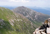
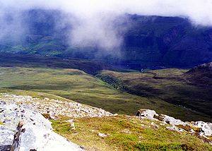
Ben Tee is a hill with few outstanding geographical features, it has a broad grassy eastern ridge which sweeps down to the northern end of Loch Lochy and the Laggan lochs and gives one of the most popular approaches to the mountain. The southern slopes of the mountain drop very steeply to the valley of the Allt a’ Choire Ghlais, a stream which drains eastwards entering a steeply wooded gorge where it changes its name to the Kilfinnan Burn. The gorge contains the Kilfillan Falls, a series of waterfalls, as the burn drains to the Great Glen at the north end of Loch Lochy.To the north, the mountain descends to Glen Garry with the trees of the Glengarry forest appearing on the slopes below the 350 metre contour. There are steep slopes to the east which go down to the Bealach Easain, a col
Mountain pass
A mountain pass is a route through a mountain range or over a ridge. If following the lowest possible route, a pass is locally the highest point on that route...
with a height of 548 metres which connects to the adjacent Munro of Sròn a' Choire Ghairbh, the col contains a small loch
Loch
Loch is the Irish and Scottish Gaelic word for a lake or a sea inlet. It has been anglicised as lough, although this is pronounced the same way as loch. Some lochs could also be called a firth, fjord, estuary, strait or bay...
an at its highest point. All drainage from Ben Tee reaches the Great Glen but interestingly goes to both the west and east coast of Scotland. Rainfall on the northern part of the hill goes via Glen Garry and the River Garry to reach Loch Oich from where it flows north east through Loch Ness
Loch Ness
Loch Ness is a large, deep, freshwater loch in the Scottish Highlands extending for approximately southwest of Inverness. Its surface is above sea level. Loch Ness is best known for the alleged sightings of the cryptozoological Loch Ness Monster, also known affectionately as "Nessie"...
to reach the east coast at the Moray Firth
Moray Firth
The Moray Firth is a roughly triangular inlet of the North Sea, north and east of Inverness, which is in the Highland council area of north of Scotland...
. Rainfall on the southern slopes goes via the Kilfinnan Burn to reach Loch Lochy where it flows south west to reach the sea loch of Loch Linnhe
Loch Linnhe
Loch Linnhe is a sea loch on the west coast of Scotland....
on the west coast.
Ascents
The most popular ascent of Ben Tee starts at the Laggan locks on the Caledonian CanalCaledonian Canal
The Caledonian Canal is a canal in Scotland that connects the Scottish east coast at Inverness with the west coast at Corpach near Fort William. It was constructed in the early nineteenth century by engineer Thomas Telford, and is a sister canal of the Göta Canal in Sweden, also constructed by...
at grid reference where there is a car park. The minor road to Kilfinnan on the north side of Loch Lochy is taken and left about 200 metres before the Kilfinnan Burn is reached to strike north west up the steep slopes of Ben Tee. Do not take the path to the Kilfinnan Falls as it is not possible to exit the gorge further up, however the falls are worth visiting but steps will have to be retraced. The route continues across moorland which steepens to reach the broad eastern ridge and then the summit. Approaches are possible from the north and the east, one starts at the bridge over Loch Garry
Loch Garry
Loch Garry, , is 25 km north of Fort William, Lochaber, Scotland, and is 11 km long and 50 m deep. It is fed by waters from Loch Quoich 10 km upstream on the River Garry, and drains into Loch Oich in the Great Glen just 5 km downstream...
(grid reference ), while another starts at the Forestry Commission’s Alt na Cailliche car park near Invergarry (grid reference ). Both these routes are longer than the Kilfinnan approach.