
Sellwood Bridge
Encyclopedia
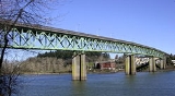
The Sellwood Bridge is a truss bridge
that spans the Willamette River
in Portland, Oregon
, in the United States
. It was Portland's first fixed-span bridge and, being the only river crossing for miles in each direction, is the busiest two-lane bridge in Oregon
. It links the Sellwood
and Westmoreland
neighborhoods of Portland on the east side with Oregon Route 43/Macadam Avenue on the west side. At its east end it leads to Tacoma Street. The bridge is owned and operated by Multnomah County
.
Designed by Gustav Lindenthal
, the bridge opened on December 15, 1925 at a final cost of $541,000. It is 1971 feet (600.8 m) long with 75 feet (22.9 m) of vertical waterway clearance. It has four continuous spans, all of Warren type. The two center spans are 300 feet (91.4 m) long, and the two outside spans are 246 feet (75 m) each. The girders from the old Burnside Bridge
(built in 1894) were reused at each end. The two-lane roadway is 24 feet (7.3 m) wide. There is a sidewalk
on the downstream side only, with a width of 4 in 3 in (1.3 m); however, the street light foundations share space with the sidewalk, making the sidewalk's usable width at those points about 3 feet (36 inches, 91 cm). Allowing for safety clearances, there is less than 2 feet (24 inches, 61 cm) of usable sidewalk. The Bicycle Transportation Alliance
lists the Sellwood Bridge as one of the top ten priorities for improving Portland's bicycling.
The bridge's condition has been deteriorating since the 1960s, and it is now set to be replaced by a new bridge, construction of which is targeted to begin in 2012, however as of 2011, $25 million is still needed. In an October 2011 study, the Department of Transportation wrote that the Sellwood Bridge must be replaced 'immediately'.
bus trips. Over the few years that followed, there was debate on whether the bridge should be replaced, repaired, closed altogether, or closed for automotive traffic (but left open for pedestrians and bicycles). In April 2005, Bechtel
gave Multnomah County
an unsolicited plan to replace the bridge through a public-private partnership.
containing details on five different finalist designs and alignments.
In February 2009, the Policy Advisory Group (PAG), based on recommendations provide by a Community Task Force and the public, selected a Locally Preferred Alternative (LPA). The LPA includes replacement of the existing bridge with a new bridge, alignment approximately 15 feet south of Tacoma Street, allowing continuous traffic flow at the crossing during construction, a pedestrian-actuated signal at Tacoma Street and SE 6th Avenue, and a signal at the west end interchange. The LPA is 64 feet (or less) wide and consists of two traffic lanes, two bike lanes
, and two 12 feet (3.7 m) wide sidewalks. A final Environmental Impact Statement was published in spring 2010, and it was approved by the Federal Highway Administration
in July 2010.
After evaluation in 2010 of several different possible designs, a two-lane steel deck arch bridge was chosen for the replacement bridge. This was approved by the Multnomah County Commission on January 27, 2011. The new bridge will be strong enough to carry streetcars and the design will include some provisions intended to make the potential installation of a streetcar line across the bridge easier, should city officials later decide to build such a line, but plans to include streetcar tracks in the new bridge's initial construction were dropped in January 2011, to reduce costs. However, they had only been added to the plans three months earlier.
In October 2009, the Multnomah County board of commissioners approved a plan to levy an annual $19 registration fee on vehicles registered in the county, to provide its share of the cost of the replacement bridge. Collection of the new fee began in 2010 and is scheduled to continue for 20 years, raising approximately $127 million. As owner of the bridge, the county's contribution is the largest component of the funding plan, but several other governments are also due to share in the cost of the project, under a funding agreement approved in early February 2011. In addition to the $127 million from Multnomah County, the City of Portland has agreed to provide $100 million, the state of Oregon $30 million, Clackamas County
$22 million, and the federal government $11 million. As of February 2011, about $20 million of the estimated $290 million cost has still to be found. Due to a general shortage of funds, the project has been scaled back in scope from earlier plans that would have cost $330 million.
Clackamas County's share was scheduled to come from a $5-per-year increase in vehicle registration fees, starting in 2012. This plan was approved by that county's board of commissioners in December 2010. However, some county residents opposed the idea, on the basis that the bridge is located within Multnomah County. Bridge project officials pointed out that traffic statistics had shown that 70% of the daily trips across the bridge start or end in Clackamas County, while a not-dissimilar percentage of the trips, about 80%, start or end in Multnomah County, arguing that residents of both counties thereby appear to benefit about equally from the bridge. Opponents nevertheless succeeded in gathering enough signatures on initiative
petitions to place the matter on the ballot for a public vote by Clackamas County residents on May 17, 2011.
The results from the May 17, 2011 special election were 37% in favor of the $5 fee, and 63% against. Measure 3-372 failed. As a result, Multnomah County has decided to move ahead with bridge construction and hope to fill the funding gap as construction occurs.
Truss bridge
A truss bridge is a bridge composed of connected elements which may be stressed from tension, compression, or sometimes both in response to dynamic loads. Truss bridges are one of the oldest types of modern bridges...
that spans the Willamette River
Willamette River
The Willamette River is a major tributary of the Columbia River, accounting for 12 to 15 percent of the Columbia's flow. The Willamette's main stem is long, lying entirely in northwestern Oregon in the United States...
in Portland, Oregon
Portland, Oregon
Portland is a city located in the Pacific Northwest, near the confluence of the Willamette and Columbia rivers in the U.S. state of Oregon. As of the 2010 Census, it had a population of 583,776, making it the 29th most populous city in the United States...
, in the United States
United States
The United States of America is a federal constitutional republic comprising fifty states and a federal district...
. It was Portland's first fixed-span bridge and, being the only river crossing for miles in each direction, is the busiest two-lane bridge in Oregon
Oregon
Oregon is a state in the Pacific Northwest region of the United States. It is located on the Pacific coast, with Washington to the north, California to the south, Nevada on the southeast and Idaho to the east. The Columbia and Snake rivers delineate much of Oregon's northern and eastern...
. It links the Sellwood
Sellwood, Portland, Oregon
Sellwood-Moreland is a neighborhood on a bluff overlooking the Willamette River in Southeast Portland, Oregon, bordering Westmoreland to the north, Eastmoreland to the east, and the city of Milwaukie to the south...
and Westmoreland
Westmoreland, Portland, Oregon
Westmoreland is a neighborhood of Southeast Portland, bordering Brooklyn to the north, the Willamette River to the west, Eastmoreland to the east, and Sellwood to the south...
neighborhoods of Portland on the east side with Oregon Route 43/Macadam Avenue on the west side. At its east end it leads to Tacoma Street. The bridge is owned and operated by Multnomah County
Multnomah County, Oregon
Multnomah County is one of 36 counties in the U.S. state of Oregon. Though smallest in area, it is the most populous as its county seat, Portland, is the state's largest city...
.
Designed by Gustav Lindenthal
Gustav Lindenthal
Gustav Lindenthal was a civil engineer who designed the Hell Gate Bridge among other bridges.Lindenthal's work was greatly affected by his pursuit for perfection and his love of art. His structures not only serve the purpose they were designed for, but are aesthetically pleasing to the public eye...
, the bridge opened on December 15, 1925 at a final cost of $541,000. It is 1971 feet (600.8 m) long with 75 feet (22.9 m) of vertical waterway clearance. It has four continuous spans, all of Warren type. The two center spans are 300 feet (91.4 m) long, and the two outside spans are 246 feet (75 m) each. The girders from the old Burnside Bridge
Burnside Bridge
The Burnside Bridge is a bascule bridge that spans the Willamette River in Portland, Oregon.-Design:Including approaches, the Burnside has a total length of and a center span. While lowered this span is normally above the river. The deck is made of concrete, which contributes to its being one of...
(built in 1894) were reused at each end. The two-lane roadway is 24 feet (7.3 m) wide. There is a sidewalk
Sidewalk
A sidewalk, or pavement, footpath, footway, and sometimes platform, is a path along the side of a road. A sidewalk may accommodate moderate changes in grade and is normally separated from the vehicular section by a curb...
on the downstream side only, with a width of 4 in 3 in (1.3 m); however, the street light foundations share space with the sidewalk, making the sidewalk's usable width at those points about 3 feet (36 inches, 91 cm). Allowing for safety clearances, there is less than 2 feet (24 inches, 61 cm) of usable sidewalk. The Bicycle Transportation Alliance
Bicycle Transportation Alliance
The Bicycle Transportation Alliance is a 501 non-profit bicycle advocacy organization based in Portland, Oregon, United States. The BTA promotes bicycling and the improvement of bicycling conditions in Oregon and southwest Washington through advocacy, programs and events. The BTA has a membership...
lists the Sellwood Bridge as one of the top ten priorities for improving Portland's bicycling.
The bridge's condition has been deteriorating since the 1960s, and it is now set to be replaced by a new bridge, construction of which is targeted to begin in 2012, however as of 2011, $25 million is still needed. In an October 2011 study, the Department of Transportation wrote that the Sellwood Bridge must be replaced 'immediately'.
Replacement
Upon discovery of cracks in both concrete approaches in January 2004, the weight limit on the bridge was lowered from 32 tons to 10 tons. This has caused the diversion of about 1,400 daily truck and bus trips, including 94 daily TriMetTriMet
TriMet, more formally known as the Tri-County Metropolitan Transportation District of Oregon, is a public agency that operates mass transit in a region that spans most of the Portland metropolitan area in the U.S. state of Oregon...
bus trips. Over the few years that followed, there was debate on whether the bridge should be replaced, repaired, closed altogether, or closed for automotive traffic (but left open for pedestrians and bicycles). In April 2005, Bechtel
Bechtel
Bechtel Corporation is the largest engineering company in the United States, ranking as the 5th-largest privately owned company in the U.S...
gave Multnomah County
Multnomah County, Oregon
Multnomah County is one of 36 counties in the U.S. state of Oregon. Though smallest in area, it is the most populous as its county seat, Portland, is the state's largest city...
an unsolicited plan to replace the bridge through a public-private partnership.
Design
In July 2007, the Multnomah County Board of Commissioners considered several options for a replacement bridge. At the time, the top option was a 75 feet (22.9 m) bridge with two car lanes and two transit lanes, running just south of the current bridge, with a projected cost of $302 million. In November 2008, however, the Sellwood Bridge team issued a draft Environmental Impact StatementEnvironmental impact statement
An environmental impact statement , under United States environmental law, is a document required by the National Environmental Policy Act for certain actions "significantly affecting the quality of the human environment". An EIS is a tool for decision making...
containing details on five different finalist designs and alignments.
In February 2009, the Policy Advisory Group (PAG), based on recommendations provide by a Community Task Force and the public, selected a Locally Preferred Alternative (LPA). The LPA includes replacement of the existing bridge with a new bridge, alignment approximately 15 feet south of Tacoma Street, allowing continuous traffic flow at the crossing during construction, a pedestrian-actuated signal at Tacoma Street and SE 6th Avenue, and a signal at the west end interchange. The LPA is 64 feet (or less) wide and consists of two traffic lanes, two bike lanes
Segregated cycle facilities
Segregated cycle facilities are marked lanes, tracks, shoulders and paths designated for use by cyclists from which motorised traffic is generally excluded...
, and two 12 feet (3.7 m) wide sidewalks. A final Environmental Impact Statement was published in spring 2010, and it was approved by the Federal Highway Administration
Federal Highway Administration
The Federal Highway Administration is a division of the United States Department of Transportation that specializes in highway transportation. The agency's major activities are grouped into two "programs," the Federal-aid Highway Program and the Federal Lands Highway Program...
in July 2010.
After evaluation in 2010 of several different possible designs, a two-lane steel deck arch bridge was chosen for the replacement bridge. This was approved by the Multnomah County Commission on January 27, 2011. The new bridge will be strong enough to carry streetcars and the design will include some provisions intended to make the potential installation of a streetcar line across the bridge easier, should city officials later decide to build such a line, but plans to include streetcar tracks in the new bridge's initial construction were dropped in January 2011, to reduce costs. However, they had only been added to the plans three months earlier.
Cost and funding
In July 2009, Governor Ted Kulongoski signed the Oregon Jobs and Transportation Act of 2009, which includes funding for the new Sellwood Bridge. The Act designates $30 million to build a new interchange at the west end, permits Multnomah and Clackamas counties to fund the project through local vehicle registration fees, and allocates transportation funds from state vehicle fees and gas taxes.In October 2009, the Multnomah County board of commissioners approved a plan to levy an annual $19 registration fee on vehicles registered in the county, to provide its share of the cost of the replacement bridge. Collection of the new fee began in 2010 and is scheduled to continue for 20 years, raising approximately $127 million. As owner of the bridge, the county's contribution is the largest component of the funding plan, but several other governments are also due to share in the cost of the project, under a funding agreement approved in early February 2011. In addition to the $127 million from Multnomah County, the City of Portland has agreed to provide $100 million, the state of Oregon $30 million, Clackamas County
Clackamas County, Oregon
Clackamas County is a county located in the U.S. state of Oregon. The county was named after the Native Americans living in the area, the Clackamas Indians, who were part of the Chinookan people. As of 2010, the population was 375,992...
$22 million, and the federal government $11 million. As of February 2011, about $20 million of the estimated $290 million cost has still to be found. Due to a general shortage of funds, the project has been scaled back in scope from earlier plans that would have cost $330 million.
Clackamas County's share was scheduled to come from a $5-per-year increase in vehicle registration fees, starting in 2012. This plan was approved by that county's board of commissioners in December 2010. However, some county residents opposed the idea, on the basis that the bridge is located within Multnomah County. Bridge project officials pointed out that traffic statistics had shown that 70% of the daily trips across the bridge start or end in Clackamas County, while a not-dissimilar percentage of the trips, about 80%, start or end in Multnomah County, arguing that residents of both counties thereby appear to benefit about equally from the bridge. Opponents nevertheless succeeded in gathering enough signatures on initiative
Initiative
In political science, an initiative is a means by which a petition signed by a certain minimum number of registered voters can force a public vote...
petitions to place the matter on the ballot for a public vote by Clackamas County residents on May 17, 2011.
The results from the May 17, 2011 special election were 37% in favor of the $5 fee, and 63% against. Measure 3-372 failed. As a result, Multnomah County has decided to move ahead with bridge construction and hope to fill the funding gap as construction occurs.
External links
- Multnomah County: Sellwood Bridge Project Information, announcements, surveys related to addressing Sellwood Bridge users' needs, including Draft Environmental Impact Statement.