
Southwest Corridor
Encyclopedia
The Southwest Corridor or Southwest Expressway was a project designed to bring an eight-lane highway into the City of Boston from a direction southwesterly of downtown. It was supposed to connect with Interstate 95
(I-95) at Route 128. It would follow the right of way for the then Penn Central Railroad's Franklin Line
running from Readville, north through Forest Hills and Jamaica Plain, where it would meet the proposed I-695 (Inner Belt Expressway)
.
's Master Highway Plan for Metropolitan Boston, went through several adjustments and then was killed in 1973 by Governor Francis Sargent, following popular pressure. Governor Sargent declared a moratorium on all expressway construction within Route 128 in 1970 following the recommendation of a task force of private experts he appointed to study controversial highway plans. Having been witness to recent housing clearances for the Interstate 93
expressway and Massachusetts Turnpike
, as well as similar projects in New York City
and other cities, the population of the affected area was largely unwilling
to repeat similar costs for another expressway.
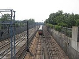
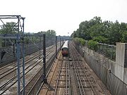 The corridor was later recycled into the new route for the MBTA's
Orange line
and Amtrak's
Northeast Corridor
with much of the surface area being developed as a 52 acre (210,000 m²) linear park.
The Southwest Corridor Park
, maintained by the state DCR, has become a vibrant space for pedestrians, bicyclists, dog-walkers, amateur sports leagues, and community gardeners. The Southwest Corridor Park Conservancy helps maintain gardens, runs summer youth projects in the park, and keeps a website with maps and photos.http://www.swcpc.org/index.htm
The Route 128/I-93/I-95 interchange was partially constructed, leaving a few abandoned ramps north of the interchange and one abandoned bridge (42.208876°N 71.142483°W) just west of the two active bridges.
Interstate 95 in Massachusetts
Interstate 95 is the main highway on the East Coast of the United States, paralleling the Atlantic Ocean from Florida to Maine. The Massachusetts portion of the highway enters from the state of Rhode Island in Attleboro and travels in a northeasterly direction to the junction with Route 128 in...
(I-95) at Route 128. It would follow the right of way for the then Penn Central Railroad's Franklin Line
Franklin Line
The Franklin Line of the MBTA Commuter Rail runs from Boston's South Station in a southwesterly direction toward Franklin, Massachusetts. Most Franklin Line trains connect to the Providence/Stoughton Line at Readville though some weekday trains use the Fairmount Line to access South Station...
running from Readville, north through Forest Hills and Jamaica Plain, where it would meet the proposed I-695 (Inner Belt Expressway)
Interstate 695 (Massachusetts)
The Inner Belt in Boston was a planned six-lane, limited-access highway that would have run through parts of Boston, Brookline, Cambridge, and Somerville.-History:...
.
History
The project started in 1948 with Massachusetts Public Works director William F. CallahanWilliam F. Callahan
William Francis Callahan was a Massachusetts civil servant who served as Commissioner of Public Works from 1934-1952 and Chairman of the Massachusetts Turnpike Authority from 1952 until his death in 1964. Callahan developed the Master Highway Plan for Metropolitan Boston, which included the...
's Master Highway Plan for Metropolitan Boston, went through several adjustments and then was killed in 1973 by Governor Francis Sargent, following popular pressure. Governor Sargent declared a moratorium on all expressway construction within Route 128 in 1970 following the recommendation of a task force of private experts he appointed to study controversial highway plans. Having been witness to recent housing clearances for the Interstate 93
Interstate 93
Interstate 93 is an Interstate Highway in the New England section of the United States. Its southern terminus is in Canton, Massachusetts, in the Boston metropolitan area, at Interstate 95; its northern terminus is near St. Johnsbury, Vermont, at Interstate 91...
expressway and Massachusetts Turnpike
Massachusetts Turnpike
The Massachusetts Turnpike is the easternmost stretch of Interstate 90. The Turnpike begins at the western border of Massachusetts in West Stockbridge connecting with the Berkshire Connector portion of the New York State Thruway...
, as well as similar projects in New York City
New York City
New York is the most populous city in the United States and the center of the New York Metropolitan Area, one of the most populous metropolitan areas in the world. New York exerts a significant impact upon global commerce, finance, media, art, fashion, research, technology, education, and...
and other cities, the population of the affected area was largely unwilling
Freeway and expressway revolts
Many freeway revolts took place in developed countries during the 1960s and 1970s, in response to plans for the construction of new freeways, a significant number of which were abandoned or significantly scaled back due to widespread public opposition; especially of those whose neighborhoods would...
to repeat similar costs for another expressway.
Current status
Massachusetts Bay Transportation Authority
The Massachusetts Bay Transportation Authority, often referred to as the MBTA or simply The T, is the public operator of most bus, subway, commuter rail and ferry systems in the greater Boston, Massachusetts, area. Officially a "body politic and corporate, and a political subdivision" of the...
Orange line
Orange Line (MBTA)
The Orange Line is one of the four subway lines of the Massachusetts Bay Transportation Authority. It extends from Forest Hills in Jamaica Plain, Boston in the south to Oak Grove in Malden, Massachusetts in the north. It meets the Red Line at Downtown Crossing, the Blue Line at State, and the Green...
and Amtrak's
Amtrak
The National Railroad Passenger Corporation, doing business as Amtrak , is a government-owned corporation that was organized on May 1, 1971, to provide intercity passenger train service in the United States. "Amtrak" is a portmanteau of the words "America" and "track". It is headquartered at Union...
Northeast Corridor
Northeast Corridor
The Northeast Corridor is a fully electrified railway line owned primarily by Amtrak serving the Northeast megalopolis of the United States from Boston in the north, via New York to Washington, D.C. in the south, with branches serving other cities...
with much of the surface area being developed as a 52 acre (210,000 m²) linear park.
The Southwest Corridor Park
Southwest Corridor Park
Southwest Corridor Park is a linear urban park in Boston, Massachusetts, part of the Metropolitan Park System of Greater Boston and managed by the Massachusetts Department of Conservation and Recreation...
, maintained by the state DCR, has become a vibrant space for pedestrians, bicyclists, dog-walkers, amateur sports leagues, and community gardeners. The Southwest Corridor Park Conservancy helps maintain gardens, runs summer youth projects in the park, and keeps a website with maps and photos.http://www.swcpc.org/index.htm
The Route 128/I-93/I-95 interchange was partially constructed, leaving a few abandoned ramps north of the interchange and one abandoned bridge (42.208876°N 71.142483°W) just west of the two active bridges.
See also
- Interstate 695Interstate 695 (Massachusetts)The Inner Belt in Boston was a planned six-lane, limited-access highway that would have run through parts of Boston, Brookline, Cambridge, and Somerville.-History:...
- A once proposed closely related project to build an inner ring expressway around downtown Boston and cutting through East CambridgeEast Cambridge, MassachusettsEast Cambridge is a neighborhood of Cambridge, Massachusetts. Referred to as Area 1, East Cambridge is bounded by the Charles River on the East, the Somerville border on the North, Broadway and Main Street on the South, and the railroad tracks on the West...
. - Freeway and expressway revoltsFreeway and expressway revoltsMany freeway revolts took place in developed countries during the 1960s and 1970s, in response to plans for the construction of new freeways, a significant number of which were abandoned or significantly scaled back due to widespread public opposition; especially of those whose neighborhoods would...