

South West Slopes, New South Wales
Encyclopedia
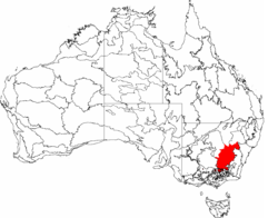
The South West Slopes is a region predominantly in New South Wales
, Australia
. It covers the lower inland slopes of the Great Dividing Range
extending from north of Cowra
through southern NSW into western Victoria
. More than 90% of the region is in the state of New South Wales and it occupies about 10% of that state.
 The south western slopes bioregion
covers the lower inland slopes of the Great Dividing Range
extending from north of Cowra
through southern NSW into eastern Victoria
. More than 90% of the region is in the state of New South Wales and it occupies about 10% of that state - more than 80,000 km².
The bioregion includes parts of the Murray
, Murrumbidgee
, Lachlan
and Macquarie River catchments
.
The region can be divided into two sub-regions:
. Conservation efforts are focussing on landholder stewardship agreements.
people, the largest Aboriginal language group in NSW.
Towns within the bioregion from Albury
in the south to Dunedoo in the northeast, include Wagga Wagga, Junee, Cootamundra, Tumut, Tumbarumba, Gundagai and Young
. Griffith
lies just outside the western boundary and Crookwell
lies just outside the eastern boundary of the bioregion.
Local Government Areas
included in the bioregion:
as the South-west Slopes of NSW Important Bird Area
(IBA) because it supports a significant wintering population of endangered Swift Parrot
s and most of the largest population of vulnerable
Superb Parrot
s, as well as populations of Painted Honeyeater
s and Diamond Firetail
s.
Most of the site is modified wheat-growing and sheep-grazing country with only vestiges of its original vegetation. Remnant patches of woodland and scattered large trees, especially of Mugga Ironbark
, Apple Box
, Grey Box
, White Box
, Yellow Box
, Red Box
, Yellow Gum
, River Red Gum and Blakely's Red Gum
, still provide habitat for the parrots. Protected areas within the site include several nature reserve
s and state forest
s, as well as the Livingstone
and Weddin Mountains National Park
s, and Tarcutta Hills Reserve
. Mean annual temperatures in the region range from 10-16°C, with an annual rainfall of 500–1150 mm.
includes Young and Tumbarumba. The area is smaller than that defined as a bioregion by the National Parks and Wildlife Service.
New South Wales
New South Wales is a state of :Australia, located in the east of the country. It is bordered by Queensland, Victoria and South Australia to the north, south and west respectively. To the east, the state is bordered by the Tasman Sea, which forms part of the Pacific Ocean. New South Wales...
, Australia
Australia
Australia , officially the Commonwealth of Australia, is a country in the Southern Hemisphere comprising the mainland of the Australian continent, the island of Tasmania, and numerous smaller islands in the Indian and Pacific Oceans. It is the world's sixth-largest country by total area...
. It covers the lower inland slopes of the Great Dividing Range
Great Dividing Range
The Great Dividing Range, or the Eastern Highlands, is Australia's most substantial mountain range and the third longest in the world. The range stretches more than 3,500 km from Dauan Island off the northeastern tip of Queensland, running the entire length of the eastern coastline through...
extending from north of Cowra
Cowra, New South Wales
Cowra is a town in the Central West region of New South Wales, Australia in the Cowra Shire. It is located on the Mid-Western Highway, 317 kilometres west of Sydney on the banks of the Lachlan River at an altitude of 310 metres above sea level. At the 2006 census Cowra had a population of 8,430...
through southern NSW into western Victoria
Victoria (Australia)
Victoria is the second most populous state in Australia. Geographically the smallest mainland state, Victoria is bordered by New South Wales, South Australia, and Tasmania on Boundary Islet to the north, west and south respectively....
. More than 90% of the region is in the state of New South Wales and it occupies about 10% of that state.
Bioregion
Ecoregion
An ecoregion , sometimes called a bioregion, is an ecologically and geographically defined area that is smaller than an ecozone and larger than an ecosystem. Ecoregions cover relatively large areas of land or water, and contain characteristic, geographically distinct assemblages of natural...
covers the lower inland slopes of the Great Dividing Range
Great Dividing Range
The Great Dividing Range, or the Eastern Highlands, is Australia's most substantial mountain range and the third longest in the world. The range stretches more than 3,500 km from Dauan Island off the northeastern tip of Queensland, running the entire length of the eastern coastline through...
extending from north of Cowra
Cowra, New South Wales
Cowra is a town in the Central West region of New South Wales, Australia in the Cowra Shire. It is located on the Mid-Western Highway, 317 kilometres west of Sydney on the banks of the Lachlan River at an altitude of 310 metres above sea level. At the 2006 census Cowra had a population of 8,430...
through southern NSW into eastern Victoria
Victoria (Australia)
Victoria is the second most populous state in Australia. Geographically the smallest mainland state, Victoria is bordered by New South Wales, South Australia, and Tasmania on Boundary Islet to the north, west and south respectively....
. More than 90% of the region is in the state of New South Wales and it occupies about 10% of that state - more than 80,000 km².
The bioregion includes parts of the Murray
Murray River
The Murray River is Australia's longest river. At in length, the Murray rises in the Australian Alps, draining the western side of Australia's highest mountains and, for most of its length, meanders across Australia's inland plains, forming the border between New South Wales and Victoria as it...
, Murrumbidgee
Murrumbidgee River
The Murrumbidgee River is a major river in the state of New South Wales, Australia, and the Australian Capital Territory . A major tributary of the Murray River, the Murrumbidgee flows in a west-northwesterly direction from the foot of Peppercorn Hill in the Fiery Range of the Snowy Mountains,...
, Lachlan
Lachlan River
- Course :The river rises in the central highland of New South Wales, part of the Great Dividing Range, 13 km east of Gunning. Its major headwaters, the Carcoar River, the Belubula River and the Abercrombie River converge near the town of Cowra. Minor tributaries include the Morongla Creek...
and Macquarie River catchments
Drainage basin
A drainage basin is an extent or an area of land where surface water from rain and melting snow or ice converges to a single point, usually the exit of the basin, where the waters join another waterbody, such as a river, lake, reservoir, estuary, wetland, sea, or ocean...
.
The region can be divided into two sub-regions:
- Northern Inland Slopes subregion
- Lower Slopes subregion
Protected areas within the bioregion
The South western Slopes of NSW are some of the most highly cleared and altered lands in the state. Native vegetation remains generally only in small, isolated patches. Substantial clearing continues. Less than 2% of the bioregion is protected as reservesProtected areas of New South Wales
The Protected areas of New South Wales include both terrestrial and aquatic protected areas. At 30 June 2010 there were 776 separate terrestrial protected areas with a total land area of . 189 of these are national parks, totalling...
. Conservation efforts are focussing on landholder stewardship agreements.
- National Parks: Benambra National Park, Conimbla National ParkConimbla National ParkConimbla is a national park in New South Wales, Australia, 253 km west of Sydney....
, Goobang National ParkGoobang National ParkGoobang is a national park in New South Wales, Australia, 296 km northwest of Sydney. It protects the largest remnant forest and woodland in the central west region of the state, where interior and coastal NSW flora and fauna species overlap....
, Livingstone National ParkLivingstone National ParkLivingstone is a national park and state conservation area located south of Wagga Wagga and east of Mangoplah, in the South West Slopes region of south western New South Wales.-History:...
, Minjary National Park, Nangar National ParkNangar National ParkNangar is a national park in New South Wales, Australia, 252 km west of Sydney. The park is located in the Nangar-Murga Range between Eugowra and Canowindra. It features Nangar Mountain, which rises to 778 metres....
, Weddin Mountains National ParkWeddin Mountains National ParkWeddin Mountains is a national park in New South Wales, Australia, 291 km west of Sydney. It is a small crescent shaped range, with a high point some 750 m above sea level, running roughly north south with steep cliffs on the eastern side sloping more gradually down to the plane in the west...
, Woomargama National ParkWoomargama National ParkWoomargama National Park is a national park situated south east of Holbrook and north east of Albury, in the South West Slopes region of southern New South Wales. Southern extremities of the park are within one kilometre of Lake Hume which is formed on the Murray River...
- Nature reserves: Avisford Nature Reserve, Big Bush Nature Reserve, Boginderra Hills Nature Reserve, Buddigower Nature Reserve, Burrinjuck Nature Reserve, Copperhannia Nature Reserve, Dananbilla Nature Reserve, Dapper Nature Reserve, Downfall Nature Reserve, Ellerslie Nature Reserve, Eugowra Nature Reserve, Flagstaff Memorial Nature Reserve, Ingalba Nature Reserve, Koorawatha Nature Reserve, Mudjarn Nature Reserve, Mullengandra Nature Reserve, Munghorn Gap Nature ReserveMunghorn Gap Nature Reservethumb|right|220px|[[Regent Honeyeater]]Munghorn Gap Nature Reserve is a 6,800 hectare reserve in eastern Australia. Situated on the Great Dividing Range, 35 km north-east of Mudgee. The Castle Rocks walking trail reveals pagoda-like sandstone formations.-Flora and fauna:Many plants and...
, Narrandera Nature Reserve, Nest Hill Nature Reserve, Pucawan Nature Reserve, Razorback Nature Reserve, Tabletop Nature Reserve, The Charcoal Tank Nature Reserve, The Rock Nature Reserve, Ulandra Nature ReserveUlandra Nature ReserveThe Ulandra Nature Reserve is a 3930 hectare nature reserve approximately south-west of Cootamundra and south-east of the village of Bethungra, in New South Wales. The reserve is located on the western hills of the Southern Tablelands. The reserve's main feature is Mount Ulandra...
, Wiesners Swamp Nature Reserve
- Historic sites: Hill End Historic Site, Yuranighs Aboriginal Grave Historic Site
Human settlement
The South Western Slopes was occupied by the WiradjuriWiradjuri
The Wiradjuri are an Indigenous Australian group of central New South Wales.In the 21st century, major Wiradjuri groups live in Condobolin, Peak Hill, Narrandera and Griffith...
people, the largest Aboriginal language group in NSW.
Towns within the bioregion from Albury
Albury, New South Wales
Albury is a major regional city in New South Wales, Australia, located on the Hume Highway on the northern side of the Murray River. It is located wholly within the boundaries of the City of Albury Local Government Area...
in the south to Dunedoo in the northeast, include Wagga Wagga, Junee, Cootamundra, Tumut, Tumbarumba, Gundagai and Young
Young, New South Wales
-Demographics:On census night, 7 August 2001, there were 6,821 people counted in Young. There were 238 people who identified as being of Indigenous origin in the 2001 Census...
. Griffith
Griffith, New South Wales
Griffith is a city in south-western New South Wales, Australia. It is also the seat of the City of Griffith local government area. Like the Australian capital, Canberra and the nearby town of Leeton, Griffith was designed by Walter Burley Griffin. Griffith was named after Sir Arthur Griffith the...
lies just outside the western boundary and Crookwell
Crookwell, New South Wales
Crookwell is a small town located in the Southern Tablelands of New South Wales, Australia, in the Upper Lachlan Shire. At the 2006 census, Crookwell had a population of 1,993 people. The town is at a relatively high altitude in Australian terms , and there are occasional snowfalls during the...
lies just outside the eastern boundary of the bioregion.
Local Government Areas
Local Government Areas of New South Wales
The local government areas of New South Wales, Australia have been subject to periodic bouts of restructuring and rationalisation by the State Government, involving voluntary and involuntary amalgamation of areas...
included in the bioregion:
- Mid-Western Regional CouncilMid-Western Regional Council, New South WalesThe Mid-Western Regional Council is a Local Government Area in the Central West of New South Wales. The Castlereagh Highway passes through the middle of the area in an approximate southeast-northwest direction....
- townships of RylstoneRylstone, New South WalesRylstone is a small town in New South Wales, Australia, in the Central Tablelands region within the Mid-Western Regional Council local government area. It is located on the Bylong Valley Way road route...
(on the border) and Mudgee - WellingtonWellington CouncilWellington Council is a local government area in the Orana region of New South Wales, Australia. It is on the Macquarie River and the Mitchell Highway....
- Cabonne Shire including the town of MolongMolong, New South WalesMolong is a small town in the Central West region of New South Wales, Australia, in Cabonne Shire.Molong is located on the Mitchell Highway about 300 kilometres west of Sydney and about 30 kilometres from the city of Orange. It is elevated at 529 metres above sea level. At the 2006 census, Molong...
- Parkes
- Forbes
- Weddin ShireWeddin ShireWeddin Shire is a Local Government Area in New South Wales, Australia. Its only significant town is Grenfell....
including the town of GrenfellGrenfell, New South WalesGrenfell is a country town in the Central West of New South Wales, Australia, in Weddin Shire. It is 370 kilometres west of Sydney and five hours' drive from the city. It is close to Forbes, Cowra and Young. At the 2006 census, Grenfell had a population of 1,994.-History:Prior to European... - Bland Shire, including the town of West WyalongWest Wyalong, New South WalesWest Wyalong is a town in New South Wales, Australia which is the main town of the Bland Shire, located in the Central West region of New South Wales. It is located 467 km west of Sydney. It is located on the crossroads of the Newell Highway between Melbourne and Brisbane, and the Mid-Western...
- Young
- Boorowa CouncilBoorowa CouncilBoorowa Shire is a local government area in New South Wales, Australia. It is on the Lachlan Valley Way.It includes Boorowa and the small towns of Rye Park, Rugby, Frogmore and Reids Flat.- Council :...
- Temora Shire
- Cootamundra Shire
- Gundagai Shire
- Tumut Shire
- Tumbarumba Shire
- City of Wagga WaggaCity of Wagga WaggaThe Wagga Wagga City Council was formed from the amalgamation of City of Wagga Wagga with Mitchell and Kyeamba Shires in 1981. 22 December 2009, Wagga Wagga City Council announced that Phil Pinyon would be appointed as the General Manager of the Wagga Wagga City Council after Lyn Russell, who...
- City of AlburyCity of AlburyThe City of Albury is a Local Government Area in the Riverina region of New South Wales, Australia. The LGA covers the entirety of the Albury urban area including the suburbs of Forrest Hill, Lavington, Thurgoona, Splitters Creek, Ettamogah, Bowna, Table Top and Wirlinga.The LGA is administered...
- Greater Hume Shire
Important Bird Area
An area of 25,653 km2, largely coincident with the bioregion, has been identified by BirdLife InternationalBirdLife International
BirdLife International is a global Partnership of conservation organisations that strives to conserve birds, their habitats and global biodiversity, working with people towards sustainability in the use of natural resources...
as the South-west Slopes of NSW Important Bird Area
Important Bird Area
An Important Bird Area is an area recognized as being globally important habitat for the conservation of bird populations. Currently there are about 10,000 IBAs worldwide. The program was developed and sites are identified by BirdLife International...
(IBA) because it supports a significant wintering population of endangered Swift Parrot
Swift Parrot
The Swift Parrot breeds in Tasmania and migrates north to south eastern Australia from Griffith-Warialda in New South Wales and west to Adelaide in the winter. It is related to the rosellas, with the feeding habits of a lorikeet...
s and most of the largest population of vulnerable
Vulnerable species
On 30 January 2010, the IUCN Red List of Threatened Species identified 9694 Vulnerable species, subspecies and varieties, stocks and sub-populations.-References:...
Superb Parrot
Superb Parrot
The Superb Parrot , is a parrot native to southeastern Australia...
s, as well as populations of Painted Honeyeater
Painted Honeyeater
The Painted Honeyeater is a species of bird in the Meliphagidae family. It is monotypic within the genus Grantiella.It is endemic to Australia. Its natural habitat is subtropical or tropical dry forests...
s and Diamond Firetail
Diamond Firetail
The Diamond Firetail Stagonopleura guttata is a species of estrildid finch found in eastern Australia, from Eyre Peninsula, South Australia, to south-eastern Queensland, commonly found on the slopes of the Great Dividing Range. The bird lives in eucalypt forest and woodland, mallee country,...
s.
Most of the site is modified wheat-growing and sheep-grazing country with only vestiges of its original vegetation. Remnant patches of woodland and scattered large trees, especially of Mugga Ironbark
Eucalyptus sideroxylon
Eucalyptus sideroxylon, or Mugga, Red Ironbark or Mugga Ironbark, is a small to medium-sized or occasionally tall tree. The bark is persistent on the trunk and large branches, hard and deeply furrowed, dark grey to black, with upper limbs smooth and whitish.Adult leaves are stalked, lanceolate to...
, Apple Box
Eucalyptus bridgesiana
The Apple Box is a medium to large sized tree of the genus Eucalyptus. It occurs in south eastern Australia, typically in grassy woodland and near watercourses around the lower slopes of the Great Dividing Range....
, Grey Box
Eucalyptus microcarpa
Eucalyptus microcarpa, or Grey Box, is a species of Eucalyptus which is endemic to Australia.It is a spreading tree which has fibrous grey bark on the trunk and lower branches, but has smooth, grey-brown bark on its upper branches The flower buds have conical caps and the flowers themselves,...
, White Box
Eucalyptus albens
Eucalyptus albens known as the White Box is a common eucalyptus tree of the western slopes and plains of New South Wales and adjacent areas in Queensland and Victoria. An isolated population grows in the southern Flinders Ranges in South Australia....
, Yellow Box
Eucalyptus melliodora
Eucalyptus melliodora, commonly known as Yellow Box, is a medium sized to occasionally tall eucalypt. The bark is variable ranging from smooth with an irregular, short stocking, to covering most of the trunk, fibrous, dense or loosely held, grey, yellow or red-brown, occasionally very coarse,...
, Red Box
Eucalyptus polyanthemos
Eucalyptus polyanthemos is a small to medium sized tree,native to New South Wales, the Australian Capital Territory and Victoria in Australia...
, Yellow Gum
Eucalyptus leucoxylon
Eucalyptus leucoxylon, commonly known as the Yellow Gum, Blue Gum or White Ironbark, is a small to medium-sized tree with rough bark on the lower 1-2 metres of the trunk, above this, the bark becomes smooth with a white, yellow or bluish-grey surface...
, River Red Gum and Blakely's Red Gum
Eucalyptus blakelyi
Eucalyptus blakelyi, known as the Blakelys Red Gum is a common eucalyptus tree of the tablelands of New South Wales and adjacent areas in Queensland and Victoria. Growing to tall, the trunk is smooth, with shedding scales of bark, revealing varying colours of pink, white and grey...
, still provide habitat for the parrots. Protected areas within the site include several nature reserve
Nature reserve
A nature reserve is a protected area of importance for wildlife, flora, fauna or features of geological or other special interest, which is reserved and managed for conservation and to provide special opportunities for study or research...
s and state forest
State forest
A state forest is a forest that is administered or protected by some agency of a sovereign state.The precise application of the term varies by jurisdiction...
s, as well as the Livingstone
Livingstone National Park
Livingstone is a national park and state conservation area located south of Wagga Wagga and east of Mangoplah, in the South West Slopes region of south western New South Wales.-History:...
and Weddin Mountains National Park
Weddin Mountains National Park
Weddin Mountains is a national park in New South Wales, Australia, 291 km west of Sydney. It is a small crescent shaped range, with a high point some 750 m above sea level, running roughly north south with steep cliffs on the eastern side sloping more gradually down to the plane in the west...
s, and Tarcutta Hills Reserve
Tarcutta Hills Reserve
Tarcutta Hills Reserve is a nature reserve on the lower western slopes of the Great Dividing Range in central west New South Wales, Australia. It is south-west of Sydney, close to the Hume Highway, and south of Tarcutta...
. Mean annual temperatures in the region range from 10-16°C, with an annual rainfall of 500–1150 mm.
Forecast area for Bureau of Meteorology
The south west slopes forecast area used by the Bureau of MeteorologyBureau of Meteorology
The Bureau of Meteorology is an Executive Agency of the Australian Government responsible for providing weather services to Australia and surrounding areas. It was established in 1906 under the Meteorology Act, and brought together the state meteorological services that existed before then...
includes Young and Tumbarumba. The area is smaller than that defined as a bioregion by the National Parks and Wildlife Service.